
Willow Street is an unincorporated community and census-designated place (CDP) in Lancaster County, Pennsylvania, United States. The population was 7,578 at the 2010 census. In the early part of the 20th century the main thoroughfare in town was lined with willow trees on both sides for the length of the town, hence the community's name. As time marched on and the town grew, the road was widened and sidewalks were installed which required the trees be removed. Only a few of the original trees remain to this day.

Iowa County is a county located in the U.S. state of Iowa. As of the 2020 census, the population was 16,662. The county seat is Marengo.

New Hartford is a town in Litchfield County, Connecticut, United States. The population was 6,658 at the 2020 census. The town center is defined by the U.S. Census Bureau as the New Hartford Center census-designated place (CDP). The town is mainly a rural community consisting of farms, homes, and parks. Brodie Park and Ski Sundown are located in New Hartford.
Brownstown is an unincorporated community and census-designated place (CDP) in West Earl Township, Lancaster County, Pennsylvania, United States. As of the 2010 census the population was 2,816.
Hampton is a census-designated place (CDP) comprising the town center and surrounding developed areas of the town of Hampton, Rockingham County, New Hampshire, United States. The population of the CDP was 9,597 at the 2020 census, out of 16,214 in the entire town.
West Rutland is the central village and a census-designated place (CDP) in the town of West Rutland, Rutland County, Vermont, United States. As of the 2020 census, it had a population of 1,898, out of 2,214 in the entire town of West Rutland.

Walloon Lake is an unincorporated community and census-designated place in Charlevoix County in the U.S. state of Michigan. As of the 2010 census it had a population of 290.
Wakefield is an unincorporated community and census-designated place (CDP) within Fulton Township, Lancaster County, Pennsylvania, United States. As of the 2010 census the population was 609. It is the largest community within the "Peach Bottom" ZIP code, with the area post office on Pennsylvania Route 272 just north of town.
Middle Amana is an unincorporated community and census-designated place (CDP) in Iowa County, Iowa, United States. It is the largest of the seven villages of the Amana Colonies, all designated as a National Historic Landmark. As of the 2010 Census, the population of Middle Amana was 581.
South Amana is an unincorporated community and census-designated place (CDP) in northern Iowa County, Iowa, United States, and is part of the "seven villages" of the Amana Colonies. As of the 2010 census, it had a population of 159.

Damariscotta is a census-designated place (CDP) comprising the main village of the town of Damariscotta in Lincoln County, Maine, United States. The population was 1,142 at the 2010 census, out of 2,218 in the entire town. In the 2000 census, the village was part of the Damariscotta-Newcastle CDP.
Newcastle is a census-designated place (CDP) comprising the main village of the town of Newcastle in Lincoln County, Maine, United States. The population was 667 at the 2010 census, out of 1,752 in the entire town. In the 2000 census, the village was part of the Damariscotta-Newcastle CDP.
High Amana is an unincorporated community and census-designated place (CDP) in Iowa County, Iowa, United States, and is part of the "seven villages" of the Amana Colonies. As of the 2010 Census, the population of High Amana was 115.
West Amana is an unincorporated community and census-designated place in Iowa County, Iowa, United States, and is part of the "seven villages" of the Amana Colonies. As of the 2010 census, the population of West Amana was 135.
East Amana is an unincorporated community and census-designated place (CDP) in Iowa County, Iowa, United States, and is part of the "seven villages" of the Amana Colonies. As of the 2010 Census, the population of East Amana was 56.

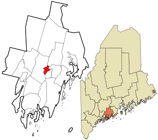
Winthrop is a census-designated place (CDP) comprising the primary settlement in the town of Winthrop in Kennebec County, Maine, United States. The population was 2,650 at the 2010 census, out of 6,092 in the town of Winthrop as a whole.

Wiscasset is a census-designated place (CDP) comprising the primary settlement in the town of Wiscasset in Lincoln County, Maine, United States. The population was 1,097 at the 2010 census, out of 3,732 people in the entire town. Wiscasset is the county seat of Lincoln County.

Amana is an unincorporated community and census-designated place (CDP) in Iowa County, Iowa, United States. It is one of the Amana Colonies, seven villages built by German Pietists in the 19th century. As of the 2020 census, Amana had a population of 388, down from 442 in the 2010 census.
Mooar is an unincorporated community and census-designated place (CDP) in Lee County, Iowa, United States. It is in the southern part of the county, 4 miles (6 km) northwest of Keokuk, the county seat. U.S. Route 61 forms the northeast edge of the CDP, leading southeast into Keokuk and north 19 miles (31 km) to Fort Madison. U.S. Route 218 runs concurrently with US-61 southeast to Keokuk, but leads northwest 16 miles (26 km) to Donnellson.
Castleton Four Corners is a census-designated place (CDP) in the town of Castleton, Rutland County, Vermont, United States. It consists of the unincorporated villages of Castleton Corners and Hydeville. As of the 2020 census, the CDP had a population of 699, out of 4,458 in the entire town.


