Jones County, Iowa

Last updated

Jones County
Jones-court-house.jpg
Map of Iowa highlighting Jones County.svg
Location within the U.S. state of Iowa
Iowa in United States.svg
Iowa's location within the U.S.
Coordinates: 42°07′12″N91°08′05″W / 42.12°N 91.134722222222°W / 42.12; -91.134722222222
CountryFlag of the United States.svg United States
StateFlag of Iowa.svg  Iowa
FoundedDecember 21, 1837
Named for George Wallace Jones
Seat Anamosa
Largest cityAnamosa
Area
  Total577 sq mi (1,490 km2)
  Land576 sq mi (1,490 km2)
  Water1.4 sq mi (4 km2)  0.2%
Population
 (2020)
  Total20,646
  Density36/sq mi (14/km2)
Time zone UTC−6 (Central)
  Summer (DST) UTC−5 (CDT)
Congressional district 1st
Website www.jonescountyiowa.gov

Jones County is a county in the U.S. state of Iowa. As of the 2020 census the population was 20,646. [1] The county seat is Anamosa. [2] The county was founded in 1837 and named after George Wallace Jones, a United States senator and member of Congress. [3] [4]

Contents

Jones County is included in the Cedar Rapids Metropolitan Statistical Area. [5]

Geography

Harvesting corn during the record 2009 season in Jones County. Iowa harvest 2009.jpg
Harvesting corn during the record 2009 season in Jones County.

According to the U.S. Census Bureau, the county has a total area of 577 square miles (1,490 km2), of which 576 square miles (1,490 km2) is land and 1.4 square miles (3.6 km2) (0.2%) is water. [6]

Major highways

Airport

Monticello Regional Airport (MXO) serves the county and surrounding communities.

Adjacent counties

Parks

Demographics

Historical population
CensusPop.Note
1850 3,007
1860 13,306342.5%
1870 19,73148.3%
1880 21,0526.7%
1890 20,233−3.9%
1900 21,9548.5%
1910 19,050−13.2%
1920 18,607−2.3%
1930 19,2063.2%
1940 19,9503.9%
1950 19,401−2.8%
1960 20,6936.7%
1970 19,868−4.0%
1980 20,4012.7%
1990 19,444−4.7%
2000 20,2214.0%
2010 20,6382.1%
2020 20,6460.0%
2023 (est.)20,900 [8] 1.2%
U.S. Decennial Census [9]
1790-1960 [10] 1900-1990 [11]
1990-2000 [12] 2010-2018 [13]
Population of Jones County from US census data JonesCountyIowaPop2020.png
Population of Jones County from US census data

2020 census

2022 US Census population pyramid for Jones County from ACS 5-year estimates JonesCountyIA2022PopPyr.png
2022 US Census population pyramid for Jones County from ACS 5-year estimates

The 2020 census recorded a population of 20,646 in the county, with a population density of

2010 census

The 2010 census recorded a population of 20,638 in the county, with a population density of

2000 census

As of the census [15] of 2000, there were 20,221 people, 7,560 households, and 5,299 families residing in the county. The population density was 35 inhabitants per square mile (14/km2). There were 8,126 housing units at an average density of 14 per square mile (5.4/km2). The racial makeup of the county was 96.68% White, 1.79% Black or African American, 0.32% Native American, 0.22% Asian, 0.23% from other races, and 0.78% from two or more races. 1.05% of the population were Hispanic or Latino of any race.

There were 7,560 households, out of which 31.00% had children under the age of 18 living with them, 59.00% were married couples living together, 7.90% had a female householder with no husband present, and 29.90% were non-families. 25.30% of all households were made up of individuals, and 12.50% had someone living alone who was 65 years of age or older. The average household size was 2.47 and the average family size was 2.95.

In the county, the population was spread out, with 24.10% under the age of 18, 7.90% from 18 to 24, 29.00% from 25 to 44, 23.30% from 45 to 64, and 15.80% who were 65 years of age or older. The median age was 38 years. For every 100 females, there were 109.30 males. For every 100 females age 18 and over, there were 111.60 males.

The median income for a household in the county was $37,449, and the median income for a family was $44,269. Males had a median income of $31,039 versus $22,075 for females. The per capita income for the county was $17,816. About 6.20% of families and 8.60% of the population were below the poverty line, including 8.80% of those under age 18 and 10.20% of those age 65 or over.

Communities

Cities

Census-designated places

Other unincorporated communities

Townships

Population ranking

The population ranking of the following table is based on the 2020 census of Jones County. [1]

county seat

RankCity/Town/etc.Municipal typePopulation (2020 Census)
1 Anamosa City5,450
2 Monticello City4,040
3 Cascade (partially in Dubuque County )City2,386
4 Olin City651
5 Wyoming City523
6 Oxford Junction City424
7 Martelle City249
8 Onslow City201
9 Stone City CDP186
10 Center Junction CDP100
11 Morley City96

Politics

After voting for the Democratic nominee in its first two elections in 1848 and 1852 prior to the founding of the Republican Party, Jones County thereafter leaned Republican until 1988. It voted Democrat only four times between 1856 and 1984, in 1912 for Woodrow Wilson when he won with a plurality of the vote after former Republican Theodore Roosevelt ran as the Progressive candidate, leading to a fracture in the national Republican Party, then backing Franklin D. Roosevelt in his two landslide victories of 1932 and 1936, and then supporting Lyndon B. Johnson during his 1964 landslide. From 1988 to 2012, Jones County favored the Democratic nominee in each election. In 2016, Donald Trump flipped the county back to the Republican column, capturing over 56% of the county's vote, the best Republican performance in the county since the 1972 landslide victory of Richard Nixon. Trump increased his vote share to almost 60% in 2020 and increased his margin of victory to over 21%, the first election in the county decided by a margin of over 20% since 1964.

United States presidential election results for Jones County, Iowa [16]
Year Republican Democratic Third party
No.%No.%No.%
2020 6,57259.81%4,21338.34%2041.86%
2016 5,72056.45%3,78737.37%6266.18%
2012 4,72145.18%5,53452.96%1941.86%
2008 4,40544.01%5,44654.42%1571.57%
2004 4,83448.45%5,05450.65%900.90%
2000 4,20145.95%4,69051.30%2522.76%
1996 3,08335.93%4,66854.40%8309.67%
1992 3,07134.51%3,50839.42%2,32126.08%
1988 3,49642.71%4,64156.70%480.59%
1984 4,90755.82%3,82543.51%590.67%
1980 4,50650.56%3,52139.50%8869.94%
1976 4,46350.54%4,24548.07%1231.39%
1972 4,96258.23%3,46840.70%911.07%
1968 4,51353.65%3,41540.60%4845.75%
1964 3,15436.37%5,51163.55%70.08%
1960 5,54158.52%3,92441.44%40.04%
1956 5,60562.51%3,35237.38%100.11%
1952 6,07066.90%2,99132.97%120.13%
1948 4,29051.55%3,91547.04%1171.41%
1944 4,45355.44%3,56344.36%160.20%
1940 5,63056.70%4,27343.04%260.26%
1936 4,14144.26%5,05254.00%1631.74%
1932 3,50041.17%4,95258.25%490.58%
1928 5,09062.83%2,97636.74%350.43%
1924 4,52457.14%2,21227.94%1,18214.93%
1920 5,96270.46%2,43628.79%630.74%
1916 2,84858.62%1,96640.47%440.91%
1912 1,62235.52%2,18947.93%75616.55%
1908 2,45352.11%2,17646.23%781.66%
1904 2,83359.17%1,83438.30%1212.53%
1900 3,02158.72%2,05239.88%721.40%
1896 3,05757.84%2,14340.55%851.61%

See also

Related Research Articles

<span class="mw-page-title-main">Douglas County, Colorado</span> County in Colorado, United States

Douglas County is a county located in the U.S. state of Colorado. As of the 2020 Census, the population was 357,978. The county is named in honor of U.S. Senator Stephen A. Douglas. The county seat is Castle Rock.

<span class="mw-page-title-main">Lafayette County, Wisconsin</span> County in Wisconsin, United States

Lafayette County, sometimes spelled La Fayette County, is a county located in the U.S. state of Wisconsin. It was part of the Wisconsin Territory at the time of its founding. As of the 2020 census, the population was 16,611. Its county seat is Darlington. The county was named in honor of the Marquis de Lafayette, the French general who rendered assistance to the Continental Army in the American Revolutionary War. The courthouse scenes from the 2009 film Public Enemies were filmed at the Lafayette County Courthouse in Darlington.

<span class="mw-page-title-main">Skamania County, Washington</span> County in Washington, United States

Skamania County is a county located in the U.S. state of Washington. As of the 2020 census, the population was 12,036. The county seat and largest incorporated city is Stevenson, although the Carson River Valley CDP is more populous. Skamania County is included in the Portland-Vancouver-Hillsboro, OR-WA Metropolitan Statistical Area.

<span class="mw-page-title-main">Cumberland County, Virginia</span> County in Virginia, United States

Cumberland County is a county located in the Commonwealth of Virginia, United States. As of the 2020 census, the population was 9,675. Its county seat is Cumberland.

<span class="mw-page-title-main">Tishomingo County, Mississippi</span> County in Mississippi, United States

Tishomingo County is a county located in the northeastern corner of the U.S. state of Mississippi. As of the 2020 census, the population was 18,850. Its county seat is Iuka.

<span class="mw-page-title-main">Scott County, Iowa</span> County in Iowa, United States

Scott County is a county located in the U.S. state of Iowa. As of the 2020 census, the population was 174,669, making it the third-most populous county in Iowa. The county seat is Davenport.

<span class="mw-page-title-main">Polk County, Iowa</span> County in Iowa, United States

Polk County is located in the U.S. state of Iowa. As of the 2020 census, the population was 492,401. It is Iowa's most populous county, and home to over 15% of the state's residents. The county seat is Des Moines, which is also the capital city of Iowa. Polk County is included in the Des Moines–West Des Moines, IA Metropolitan Statistical Area.

<span class="mw-page-title-main">Linn County, Iowa</span> County in Iowa, United States

Linn County is a county located in the U.S. state of Iowa. As of the 2020 census, the population was 230,299, making it the second-most populous county in Iowa. The county seat is Cedar Rapids. Linn County is named in honor of Senator Lewis F. Linn of Missouri. Linn County is included in the Cedar Rapids, IA Metropolitan Statistical Area.

<span class="mw-page-title-main">Independence, Iowa</span> City in Iowa, United States

Independence is a city in, and the county seat of, Buchanan County, Iowa, United States. The population was 6,064 at the 2020 census.

<span class="mw-page-title-main">Anamosa, Iowa</span> City in Iowa, United States

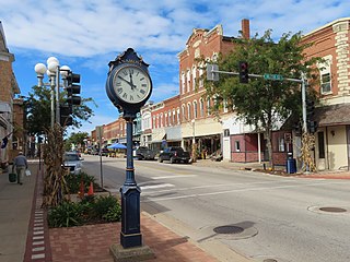
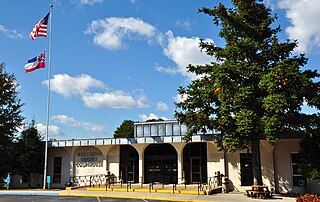
Anamosa is a city in Jones County, Iowa, United States. The population was 5,450 at the 2020 census. It is the county seat of Jones County.

<span class="mw-page-title-main">Martelle, Iowa</span> City in Iowa, United States

Martelle, Iowa is a city in Jones County, Iowa, United States. The population was 249 at the time of the 2020 census. It is part of the Cedar Rapids Metropolitan Statistical Area.

<span class="mw-page-title-main">Morley, Iowa</span> City in Iowa, United States

Morley is a city in Jones County, Iowa, United States. The population was 96 at the time of the 2020 census. It is part of the Cedar Rapids Metropolitan Statistical Area.

<span class="mw-page-title-main">Olin, Iowa</span> City in Iowa, United States

Olin is a city in Jones County, Iowa, United States. The population was 651 at the time of the 2020 census. It is part of the Cedar Rapids Metropolitan Statistical Area.

<span class="mw-page-title-main">Colo, Iowa</span> City in Iowa, United States

Colo is a city in Story County, Iowa, United States. The population was 845 at the 2020 census. The Lincoln Highway and Jefferson Highway both pass through Colo. It is part of the Ames, Iowa Metropolitan Statistical Area, which is a part of the larger Ames-Boone, Iowa Combined Statistical Area.

<span class="mw-page-title-main">Monticello, Minnesota</span> City in Minnesota, United States

Monticello is a city next to the Mississippi River in Wright County, Minnesota, United States. The population was 14,455 at the 2020 census.

Erin is a town in Chemung County, New York, United States. The population was 1,820 at the 2020 census. The town was named by early settlers from Ireland.

<span class="mw-page-title-main">Wapsipinicon River</span> River in Iowa and Minnesota in the United States of America

The Wapsipinicon River is a tributary of the Mississippi River, approximately 300 miles (480 km) long, starting near the southeastern border of Minnesota and running through northeastern Iowa in the United States. It drains a rural farming region of rolling hills and bluffs north of Waterloo and Cedar Rapids.

<span class="mw-page-title-main">Stone City, Iowa</span> Census-designated place in Iowa, United States

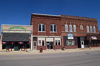
Stone City is an unincorporated community and census-designated place in Jones County, Iowa, United States. Stone City began as a company town for the workers of the local quarries. Stone City is known for its Anamosa Limestone quarries, historic limestone architecture, and 1930s art colony.

<span class="mw-page-title-main">Monticello, Iowa</span> City in Iowa, United States

Monticello is a city in Jones County, Iowa, United States. As of the 2020 census, the city population was 4,040.

<span class="mw-page-title-main">Wapsipinicon State Park</span> Park near Anamosa, Iowa

Wapsipinicon State Park is located south of Anamosa, Iowa, United States. The 394-acre (159 ha) park is along the sandstone and limestone bluffs of the Wapsipinicon River, from which it derives its name. It is one of the oldest state parks in Iowa, and it was listed as a historic district on the National Register of Historic Places in 2014.

References

  1. 1 2 3 "2020 Census State Redistricting Data". census.gov. United states Census Bureau. Retrieved August 12, 2021.
  2. "Find a County". National Association of Counties. Archived from the original on May 31, 2011. Retrieved June 7, 2011.
  3. Corbit, Robert McClain (1910). History of Jones County, Iowa: Past and Present, Volume 1. S. J. Clarke Publishing Company. p. 27.
  4. Gannett, Henry (1905). The Origin of Certain Place Names in the United States. Govt. Print. Off. pp.  170.
  5. United States Office of Management and Budget. "Update of Statistical Area Definitions and Guidance on Their Uses" (PDF). pp. 5, 36. Archived from the original (PDF) on May 14, 2006. Retrieved July 21, 2006.
  6. "US Gazetteer files: 2010, 2000, and 1990". United States Census Bureau. February 12, 2011. Retrieved April 23, 2011.
  7. "Iowa Rock Climbing at Pictured Rocks State Park". Midwest Outside. Archived from the original on July 11, 2019. Retrieved June 19, 2019.
  8. "Annual Estimates of the Resident Population for Counties: April 1, 2020 to July 1, 2023". United States Census Bureau. Retrieved April 2, 2024.
  9. "U.S. Decennial Census". United States Census Bureau. Retrieved July 18, 2014.
  10. "Historical Census Browser". University of Virginia Library. Retrieved July 18, 2014.
  11. "Population of Counties by Decennial Census: 1900 to 1990". United States Census Bureau. Retrieved July 18, 2014.
  12. "Census 2000 PHC-T-4. Ranking Tables for Counties: 1990 and 2000" (PDF). United States Census Bureau. Archived (PDF) from the original on March 27, 2010. Retrieved July 18, 2014.
  13. "State & County QuickFacts". United States Census Bureau. Archived from the original on June 7, 2011. Retrieved July 18, 2014.
  14. "Population & Housing Occupancy Status 2010" (PDF). United States Census Bureau American FactFinder. Archived (PDF) from the original on October 16, 2020. Retrieved August 15, 2022.
  15. "U.S. Census website". United States Census Bureau . Retrieved January 31, 2008.
  16. Leip, David. "Dave Leip's Atlas of U.S. Presidential Elections". uselectionatlas.org. Retrieved April 26, 2018.

Further reading

42°07′12″N91°08′05″W / 42.12000°N 91.13472°W / 42.12000; -91.13472