Augusta is an unincorporated community situated on the Skunk River in Des Moines County, Iowa, United States. It is located 10 miles southwest of Burlington and nine miles north of Fort Madison, off U.S. Route 61 and Iowa Highway 16. The community is part of the Burlington, IA–IL Micropolitan Statistical Area.
Dewar is an unincorporated town in eastern Black Hawk County, Iowa, United States. It lies northeast of the city of Waterloo, the county seat of Black Hawk County. Its elevation is 889 feet (271 m). Although Dewar is unincorporated, it has a post office with the ZIP code of 50623, which opened on 25 October 1887.
Killduff is an unincorporated community in southeastern Jasper County, Iowa, United States. It lies along local roads southeast of the city of Newton, the county seat of Jasper County.
Prole is an unincorporated rural village in northwestern Warren County, Iowa, United States. It lies along Iowa Highway 28 northwest of the city of Indianola, the county seat of Warren County. Its elevation is 978 feet (298 m). Prole has a post office, with the ZIP code of 50229, a cafe, a floral shop and an auto repair shop by way of businesses and services.
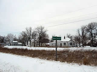
New Boston is an unincorporated community in central Lee County, Iowa, United States. It lies in the southeast corner of Iowa, along U.S. Highway 218 and southwest of the city of Fort Madison, the county seat of Lee County. New Boston is located nearby to the unincorporated communities of Argyle, Iowa and Charleston, Iowa. The community is part of the Fort Madison–Keokuk, IA-MO Micropolitan Statistical Area. There are no commercial establishments in New Boston, although this is the home of the New Boston Mennonite Church.
Buchanan is an unincorporated community in Cedar County, Iowa, United States.
Osborne is an unincorporated community in Clayton County, Iowa, United States.
Nashville is an unincorporated community in Jackson County, in the U.S. state of Iowa.
Noble is an unincorporated community in Washington County, Iowa, United States.
Olaf is an unincorporated community in Wright County, Iowa, United States.
Faulkner is an unincorporated community in Osceola Township, Franklin County, Iowa, United States. Faulkner is located along county highways C55 and S56, 4.5 miles (7.2 km) north-northwest of Ackley.
Albaton is an unincorporated community in Fairview Township, Monona County, Iowa, United States. Albaton is located in the northwest corner of the county, 4.8 miles (7.7 km) southwest of Sloan.
Lorah is an unincorporated community in Pymosa Township, Cass County, Iowa, United States. Lorah is located along U.S. routes 6 and 71, 5.5 miles (8.9 km) north-northeast of Atlantic.
Lyman is an unincorporated community in Noble Township, Cass County, Iowa, United States. Lyman is located along U.S. Route 71 and Iowa Highway 92, 12 miles (19 km) south of Atlantic.
Ladoga is an unincorporated community in Washington Township, Taylor County, Iowa, United States. Ladoga is located along County Route J35, 3 miles (4.8 km) west-southwest of Gravity.
Brainard is an unincorporated community in Fayette County, Iowa, United States. It is located at the junction of Echo Valley Road and F Avenue, four miles southwest of Elgin.
Lima is an unincorporated community in Fayette County, Iowa, United States. It is located at the junction of Ivy Road and Heron Road, four miles northeast of Fayette. and within a mile of the abandoned settlement of Albany.
Douglas is an unincorporated community in Fayette County, Iowa, United States. It is located near the junction of County Road B44 and Maple Road, three miles southwest of Eldorado.
Village Creek is an unincorporated community in Allamakee County, Iowa, United States.
Alice is an unincorporated community in Linn County, in the U.S. state of Iowa.


