
Silverlink was a train operating company in the United Kingdom owned by National Express that operated the North London Railways franchise from March 1997 until November 2007. At the end of 2007 Silverlink Metro services were taken over by London Overground and Silverlink County services were taken over by London Midland.
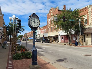
Anamosa is a city in Jones County, Iowa, United States. The population was 5,450 at the 2020 census. It is the county seat of Jones County.
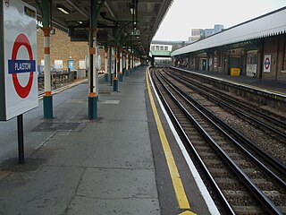
Plaistow is a London Underground station on Plaistow Road in the London Borough of Newham in Greater London. It is between West Ham and Upton Park stations on the District and Hammersmith & City lines, and in Travelcard Zone 3.

Saint Paul Union Depot is a historic railroad station and intermodal transit hub in the Lowertown neighborhood of Saint Paul, Minnesota. It serves light rail, intercity rail, intercity bus, and local bus services.

The Monon Railroad, also known as the Chicago, Indianapolis, and Louisville Railway from 1897 to 1971, was an American railroad that operated almost entirely within the state of Indiana. The Monon was merged into the Louisville and Nashville Railroad in 1971, and much of the former Monon right of way is owned today by CSX Transportation. In 1970, it operated 540 miles (870 km) of road on 792 miles (1,275 km) of track; that year it reported 1320 million ton-miles of revenue freight and zero passenger-miles.

Monti is an unincorporated community located in the southeast corner of Buchanan County, Iowa, in the United States. Founded in the 1880s and platted in 1905, the community lies on the west bank of Buffalo Creek, 6 miles (10 km) east of Quasqueton and 8 miles (13 km) west of Ryan.

The Clinton Railroad Bridge, also called the Chicago and Northwestern Railway Bridge or more simply the Clinton Bridge, is a bridge that carries double tracked rail lines across the Mississippi River between Clinton, Iowa, and Fulton (Albany), Illinois. The bridge is a truss bridge with a swing span crossing the main river channel and is adjacent to the Gateway Bridge. The original bridge was constructed in 1858, and the first train crossed the bridge on January 19, 1860. The bridge was the second railroad crossing over the Mississippi River. In 1870, the bridge was declared a post route, therefore stopping the occupation of steamboats and approval of railroads. From 1859 to 1908, the mileage in operation increased from 28,789 to 229,230, prompting the Chicago and North Western Railway to replace the bridge with a new structure in 1900.

Catherine Carroll Shelley was a midwestern United States railroad heroine and the first woman in the United States to have a bridge named after her, the Kate Shelley High Bridge. She was also one of the few women to have a train named after her, the Kate Shelley 400.

Iowa Highway 1 (Iowa 1) is a state highway in the U.S. state of Iowa that extends from Keosauqua to Anamosa. It travels nearly 120 miles (190 km), mainly through rich farmland and small communities. Iowa 1 provides an important link to Iowa City and the University of Iowa as it passes through campus. Portions of the route today date back to the late 1830s, when Martin Van Buren was president, making Iowa 1 one of the oldest routes in the state, pre-dating the current primary highway system by nearly eighty years. The highway was seriously damaged by the Cedar River in the Iowa flood of 2008, which closed the highway for seven weeks.

The Atchison, Topeka and Santa Fe Passenger and Freight Complex is a nationally recognized historic district located in Fort Madison, Iowa, United States. It was listed on the National Register of Historic Places in 1992. At the time of its nomination it contained three resources, all of which are contributing buildings. The buildings were constructed over a 24-year time period, and reflect the styles that were popular when they were built. The facility currently houses a local history museum, and after renovations a portion of it was converted back to a passenger train depot for Amtrak, which opened on December 15, 2021.
Hooping is the manipulation of and artistic movement or dancing with a hoop. Hoops can be made of metal, wood, or plastic. Hooping combines technical moves and tricks with freestyle or technical dancing. Hooping can be practiced to or performed with music. In contrast to the classic toy hula hoop, modern hoopers use heavier and larger diameter hoops, and frequently rotate the hoop around parts of the body other than the waist, including the hips, chest, neck, shoulders, thighs, knees, arms, hands, thumbs, feet, and toes. The hoop can also be manipulated and rotated off the body as well. Modern hooping has been influenced by art forms such as rhythmic gymnastics, hip-hop, freestyle dance, fire performance, twirling, poi, and other dance and movement forms.
Milwaukee Road Depot can refer to the following former and active train stations used by the Chicago, Milwaukee, St. Paul and Pacific Railroad:, Chicago, Milwaukee & St Paul, Chicago, Milwaukee & Puget Sound Railway, Idaho & Washington Northern and Washington, Idaho & Montana RY, Plus all other former variations of the Milwaukee Road.

Charles Sumner Frost was an American architect. He is best known as the architect of Navy Pier and for designing over 100 buildings for the Chicago and North Western Railway.

The Burlington, Cedar Rapids and Northern Railway (BCR&N) was a railroad that operated in the United States from 1876 to 1903. It was formed to take over the operations of the bankrupt Burlington, Cedar Rapids and Minnesota Railway, which was, in turn, the result of merging several predecessor lines, the construction of which began in 1869. The corporate headquarters were in Cedar Rapids, Iowa, and it had operations in Iowa and in Minnesota. It was succeeded by the Chicago, Rock Island and Pacific Railway.

The Wabash Railroad was a Class I railroad that operated in the mid-central United States. It served a large area, including track in the states of Ohio, Indiana, Illinois, Iowa, Michigan, and Missouri and the province of Ontario. Its primary connections included Chicago, Illinois; Kansas City, Missouri; Detroit, Michigan; Buffalo, New York; St. Louis, Missouri; and Toledo, Ohio.
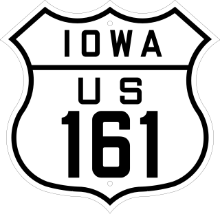
U.S. Highway 161 was a U.S. Highway in Iowa that ran from Keokuk to Dubuque by way of Cedar Rapids. It was designated in 1925 and signed in 1926 along two primary highways. The route began at the Mississippi River with US 61 southwest of Keokuk ran north through Mount Pleasant and Iowa City to Cedar Rapids. There, it turned to the northeast through Anamosa and Monticello towards Dubuque. The route ended at US 61 in Key West, a few miles west of Dubuque.
Robinson is an unincorporated community in Delaware County, Iowa, United States. It is located at the junction of County Highway D47 and 310th Street, five miles west of Ryan and three miles southeast of Monti, at 42.340037N, -91.578738W.

Capa is an unincorporated community in Jones County, South Dakota, United States.

Marion station was a railroad station in Marion, Iowa. It served passenger trains of the Chicago, Milwaukee, St. Paul and Pacific Railroad, commonly known as the Milwaukee Road. After passenger train service was discontinued, elements of the station were moved across the street to City Square Park, where it remains as a pavilion today. The structure is listed as a non-contributing property by the National Register of Historic Places in the Marion Commercial Historic District.

The Burlington and Northwestern Railway (B&NW) was a 3 ft narrow gauge railroad system in Iowa that operated during the late nineteenth and early twentieth centuries. It connected Burlington, Iowa with branches to Washington and Oskaloosa, Iowa. Incorporated in 1875 as the Burlington and Northwestern Narrow Gauge Railway Company, it began carrying traffic in 1876, when it also dropped 'narrow gauge' from its corporate name. The line reached Washington in 1880, operating over 52.5 miles (84.5 km) of track. In 1881, the Burlington and Western Railway Company, a subsidiary of the Chicago, Burlington and Quincy Railroad (CB&Q) was formed to connect the line to Oskaloosa, completed in 1883. For two decades, both lines were operated as a single system, until on June 20, 1902, the system was widened to standard gauge and the B&NW was adsorbed by the B&W. Later that year, the system was leased to the CB&Q, and in 1903, the entire system was deeded to the CB&Q.


