Morley, Iowa | |
---|---|
Coordinates: 42°0′24″N91°14′48″W / 42.00667°N 91.24667°W Coordinates: 42°0′24″N91°14′48″W / 42.00667°N 91.24667°W | |
Country | United States |
State | Iowa |
County | Jones |
Area | |
• Total | 0.09 sq mi (0.22 km2) |
• Land | 0.09 sq mi (0.22 km2) |
• Water | 0.00 sq mi (0.00 km2) |
Elevation | 797 ft (243 m) |
Population (2020) | |
• Total | 96 |
• Density | 1,116.28/sq mi (432.89/km2) |
Time zone | UTC-6 (Central (CST)) |
• Summer (DST) | UTC-5 (CDT) |
ZIP code | 52312 |
Area code | 319 |
FIPS code | 19-54030 |
GNIS feature ID | 0459231 |
Morley is a city in Jones County, Iowa, United States. The population was 96 at the time of the 2020 census. [2] It is part of the Cedar Rapids Metropolitan Statistical Area.
Morley was laid out circa 1873 on the main line of the Chicago, Milwaukee, St. Paul and Pacific Railroad. First called Viroqua, it was renamed Morley in 1886. [3]
Morley is located at 42°0′24″N91°14′48″W / 42.00667°N 91.24667°W (42.006556, -91.246719). [4]
According to the United States Census Bureau, the city has a total area of 0.09 square miles (0.23 km2), all land. [5]
Year | Pop. | ±% |
---|---|---|
1930 | 117 | — |
1940 | 119 | +1.7% |
1950 | 157 | +31.9% |
1960 | 124 | −21.0% |
1970 | 123 | −0.8% |
1980 | 94 | −23.6% |
1990 | 85 | −9.6% |
2000 | 88 | +3.5% |
2010 | 115 | +30.7% |
2020 | 96 | −16.5% |
Source: "U.S. Census website". United States Census Bureau . Retrieved 2020-03-29. and Iowa Data Center Source: |
As of the census [7] of 2010, there were 115 people, 44 households, and 30 families living in the city. The population density was 1,277.8 inhabitants per square mile (493.4/km2). There were 51 housing units at an average density of 566.7 per square mile (218.8/km2). The racial makeup of the city was 99.1% White and 0.9% from two or more races. Hispanic or Latino of any race were 0.9% of the population.
There were 44 households, of which 38.6% had children under the age of 18 living with them, 36.4% were married couples living together, 15.9% had a female householder with no husband present, 15.9% had a male householder with no wife present, and 31.8% were non-families. 25.0% of all households were made up of individuals, and 15.9% had someone living alone who was 65 years of age or older. The average household size was 2.61 and the average family size was 2.93.
The median age in the city was 40.5 years. 30.4% of residents were under the age of 18; 8.7% were between the ages of 18 and 24; 17.4% were from 25 to 44; 27.9% were from 45 to 64; and 15.7% were 65 years of age or older. The gender makeup of the city was 53.9% male and 46.1% female.
At the 2000 census, [8] there were 88 people, 43 households and 19 families living in the city. The population density was 882.1 inhabitants per square mile (340.6/km2). There were 47 housing units at an average density of 471.1 per square mile (181.9/km2). The racial makeup of the city was 98.86% White, and 1.14% from two or more races.
There were 43 households, of which 27.9% had children under the age of 18 living with them, 32.6% were married couples living together, 4.7% had a female householder with no husband present, and 55.8% were non-families. 46.5% of all households were made up of individuals, and 23.3% had someone living alone who was 65 years of age or older. The average household size was 2.05 and the average family size was 3.05.
25.0% of the population were under the age of 18, 3.4% from 18 to 24, 35.2% from 25 to 44, 15.9% from 45 to 64, and 20.5% who were 65 years of age or older. The median age was 38 years. For every 100 females, there were 125.6 males. For every 100 females age 18 and over, there were 135.7 males.
The median household income was $44,375 and the median family income was $52,500. Males had a median income of $36,250 versus $19,063 for females. The per capita income for the city was $22,167. There were no families and 4.9% of the population living below the poverty line, including no under eighteens and 18.2% of those over 64.
Anamosa Community School District operates schools serving this community. [9]
Selmont-West Selmont is a census-designated place (CDP) in Dallas County, Alabama, United States. At the 2020 census, the population was 2,158.
Lynn is a town in Lawrence County, Arkansas, United States. The population was 288 at the 2010 census.
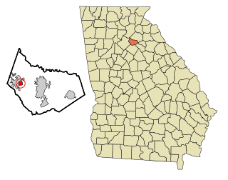
Carl is a town in Barrow County, Georgia, United States. The population was 269 at the 2016 census.
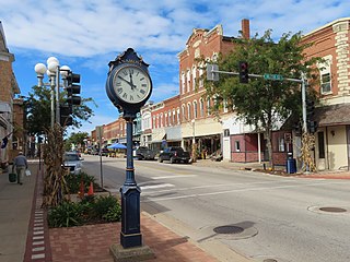
Anamosa is a city in Jones County, Iowa, United States. The population was 5,450 at the 2020 census. It is the county seat of Jones County.
Martelle, Iowa is a city in Jones County, Iowa, United States. The population was 249 at the time of the 2020 census. It is part of the Cedar Rapids Metropolitan Statistical Area.
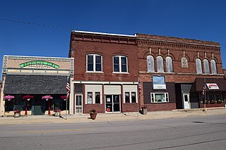
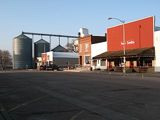
Olin is a city in Jones County, Iowa, United States. The population was 651 at the time of the 2020 census. It is part of the Cedar Rapids Metropolitan Statistical Area.
Montrose is a city in Lee County, Iowa. The population was 738 at the time of the 2020 census. The town is located on the Mississippi River. It is part of the Fort Madison–Keokuk, IA-IL-MO Micropolitan Statistical Area.
Morley is a village in Deerfield Township, Mecosta County in the U.S. state of Michigan. The population was 493 at the 2010 census.
Lilydale is a city in Dakota County, Minnesota, United States. The population was 623 at the 2010 census.
Morley is a city in Scott County, Missouri, United States. The population was 697 at the 2010 census.
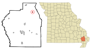
Bell City is a city in northeastern Stoddard County, Missouri, United States. It was founded as a sawmill town circa 1900, and lies at the foothills of Crowley's Ridge on Missouri Route 91. The population was 448 at the 2010 census. Dorothy Burton is the current mayor.
Cody is a village in Cherry County, Nebraska, United States. As of the 2010 census, the village had a total population of 154.
Elyria is a village in Valley County, Nebraska, United States. The population was 51 at the 2010 census.
Newton Grove, chartered in 1879, is a town in Sampson County, North Carolina, United States. The population was 569 as of the 2010 census.
Meridian is a town in eastern Logan County, Oklahoma, United States. The population was 38 at the 2010 census, a decline of 29.5 percent from the figure of 54 in 2000. It is part of the Oklahoma City Metropolitan Statistical Area. The community name was chosen because of its location on the Indian meridian.
Tygh Valley is a census-designated place (CDP) and unincorporated community in Wasco County, Oregon, United States. The population was 224 at the 2000 census.
Wayne Township is a township in Armstrong County, Pennsylvania, United States. The population was 1,296 at the 2020 census, an increase over the figure of 1,200 tabulated in 2010.
Avon is a city in Bon Homme County, South Dakota, United States. The population was 586 at the 2020 census.
Green Grass is a census-designated place (CDP) in Dewey County, South Dakota, United States. The population was 21 at the 2020 census.
Roswell is a CDP in Miner County, South Dakota, United States. The population was 8 at the 2020 census. It disincorporated as a town in 2012.