Ringgold County, Iowa

Last updated

Ringgold County
Ringgold County IA Courthouse.jpg
Map of Iowa highlighting Ringgold County.svg
Location within the U.S. state of Iowa
Iowa in United States.svg
Iowa's location within the U.S.
Coordinates: 40°43′56″N94°14′53″W / 40.732222222222°N 94.248055555556°W / 40.732222222222; -94.248055555556
CountryFlag of the United States.svg United States
StateFlag of Iowa.svg  Iowa
FoundedFebruary 24, 1847
Named for Samuel Ringgold
Seat Mount Ayr
Largest cityMount Ayr
Area
  Total539 sq mi (1,400 km2)
  Land535 sq mi (1,390 km2)
  Water3.4 sq mi (9 km2)  0.6%
Population
 (2020)
  Total4,663
  Density8.7/sq mi (3.3/km2)
Time zone UTC−6 (Central)
  Summer (DST) UTC−5 (CDT)
Congressional district 3rd
Website www.ringgoldcounty.iowa.gov

Ringgold County is a county located in the U.S. state of Iowa. As of the 2020 census, the population was 4,663, [1] making it the Iowa county with the second-smallest population. The county seat is Mount Ayr. [2] The county is named after Maj. Samuel Ringgold, a hero of the Battle of Palo Alto fought in May 1846, during the Mexican–American War. It is one of the 26 Iowa counties with a name that is unique across the nation.

Contents

Geography

According to the U.S. Census Bureau, the county has a total area of 539 square miles (1,400 km2), of which 535 square miles (1,390 km2) is land and 3.4 square miles (8.8 km2) (0.6%) is water. [3]

Major highways

Adjacent counties

Demographics

Historical population
CensusPop.Note
1860 2,923
1870 5,69194.7%
1880 12,085112.4%
1890 13,55612.2%
1900 15,32513.0%
1910 12,904−15.8%
1920 12,9190.1%
1930 11,966−7.4%
1940 11,137−6.9%
1950 9,528−14.4%
1960 7,910−17.0%
1970 6,373−19.4%
1980 6,112−4.1%
1990 5,420−11.3%
2000 5,4690.9%
2010 5,131−6.2%
2020 4,663−9.1%
2023 (est.)4,642 [4] −0.5%
U.S. Decennial Census [5]
1790-1960 [6] 1900-1990 [7]
1990-2000 [8] 2010-2018 [9]
Population of Ringgold County from US census data RinggoldCountyIowaPop2020.png
Population of Ringgold County from US census data

2020 census

2022 US Census population pyramid for Ringgold County from ACS 5-year estimates RinggoldCountyIA2022PopPyr.png
2022 US Census population pyramid for Ringgold County from ACS 5-year estimates

The 2020 census recorded a population of 4,663 in the county, with a population density of

2010 census

The 2010 census recorded a population of 5,131 in the county, with a population density of

2000 census

As of the census [11] of 2000, there were 5,469 people, 2,245 households, and 1,537 families in the county. The population density was 10 people per square mile (3.9 people/km2). There were 2,789 housing units at an average density of 5 units per square mile (1.9 units/km2). The racial makeup of the county was 99.07% White, 0.11% Black or African American, 0.22% Native American, 0.16% Asian, 0.02% from other races, and 0.42% from two or more races. 0.24% of the population were Hispanic or Latino of any race.

Of the 2,245 households 27.70% had children under the age of 18 living with them, 59.70% were married couples living together, 5.50% had a female householder with no husband present, and 31.50% were non-families. 28.60% of households were one person and 17.80% were one person aged 65 or older. The average household size was 2.37 and the average family size was 2.90.

The age distribution was 24.00% under the age of 18, 6.90% from 18 to 24, 21.40% from 25 to 44, 23.60% from 45 to 64, and 24.00% 65 or older. The median age was 43 years. For every 100 females there were 94.10 males. For every 100 females age 18 and over, there were 89.40 males.

The median household income was $29,110 and the median family income was $34,472. Males had a median income of $24,583 versus $20,606 for females. The per capita income for the county was $15,023. About 9.40% of families and 14.30% of the population were below the poverty line, including 20.40% of those under age 18 and 16.40% of those age 65 or over.

Communities

Cities

Census-designated place

Unincorporated communities

Townships

Population ranking

The population ranking of the following table is based on the 2020 census of Ringgold County. [1]

county seat

RankCity/Town/etc.Municipal typePopulation (2020 Census)
1 Mount Ayr City1,623
2 Diagonal City344
3 Kellerton City243
4 Sun Valley Lake CDP187
5 Tingley City136
6 Redding City63
7 Benton City39
8 Delphos CDP26
9 Maloy City22
10 Ellston City19
11 Beaconsfield City15
12 Clearfield (mostly in Taylor County )City6 (278 total)
13 Shannon City (partially in Union County )City6 (73 total)

Politics

United States presidential election results for Ringgold County, Iowa [12]
Year Republican Democratic Third party
No.%No.%No.%
2020 1,96872.51%70926.12%371.36%
2016 1,82467.38%75327.82%1304.80%
2012 1,36852.64%1,18645.63%451.73%
2008 1,40152.10%1,23645.97%521.93%
2004 1,46652.77%1,28646.29%260.94%
2000 1,36950.85%1,24646.29%772.86%
1996 96735.29%1,43952.52%33412.19%
1992 96733.71%1,34146.74%56119.55%
1988 1,11040.64%1,60958.92%120.44%
1984 1,51248.51%1,59351.11%120.38%
1980 1,88457.95%1,15035.37%2176.67%
1976 1,54346.25%1,73952.13%541.62%
1972 2,26468.54%1,00330.37%361.09%
1968 1,98657.05%1,23735.54%2587.41%
1964 1,57140.91%2,26058.85%90.23%
1960 2,53858.74%1,78141.22%20.05%
1956 2,71360.42%1,77539.53%20.04%
1952 3,44270.66%1,40828.91%210.43%
1948 2,48755.77%1,92243.10%501.12%
1944 2,76759.35%1,86740.05%280.60%
1940 3,50759.50%2,37440.28%130.22%
1936 3,31655.31%2,61543.62%641.07%
1932 2,08245.04%2,48053.64%611.32%
1928 3,67469.57%1,57229.77%350.66%
1924 3,14760.68%88217.01%1,15722.31%
1920 3,70272.66%1,32726.05%661.30%
1916 1,73355.46%1,35143.23%411.31%
1912 91631.28%95832.72%1,05436.00%
1908 1,94061.94%1,09234.87%1003.19%
1904 2,20069.38%83526.33%1364.29%
1900 2,31962.19%1,31135.16%992.65%
1896 2,20956.47%1,65142.20%521.33%

See also

Notes

    Related Research Articles

    <span class="mw-page-title-main">Worth County, Missouri</span> County in Missouri, United States

    Worth County is a county located in the northwestern portion of the U.S. state of Missouri. As of the 2020 census, the population was 1,973. It is the smallest county in the state in population and, excluding the independent city of St. Louis, the smallest in total area. Its county seat is Grant City. The county was organized February 8, 1861, and named for General William J. Worth, who served in the Mexican–American War. Worth County is also the youngest county in the state.

    <span class="mw-page-title-main">Union County, Iowa</span> County in Iowa, United States

    Union County is a county located in the southern part of the U.S. state of Iowa. As of the 2020 Census, the population was 12,138. The county seat is Creston. Organized at a time of tensions before the Civil War, the county was named in 1853 for the union that people wanted to preserve. Union County peaked in population at the 1900 Census. Its economy is based on agriculture and related industries.

    <span class="mw-page-title-main">Taylor County, Iowa</span> County in Iowa, United States

    Taylor County is a county located in the U.S. state of Iowa. As of the 2020 census, the population was 5,896, making it the fourth-least populous county in Iowa. The county seat is Bedford. The county was formed in 1847 and named after General and President Zachary Taylor.

    <span class="mw-page-title-main">Monroe County, Iowa</span> County in Iowa, United States

    Monroe County is a county located in the south central part of the U.S. state of Iowa. In the early 20th century, it was a center of bituminous coal mining and in 1910 had a population of more than 25,000. As mining declined, people moved elsewhere for work. In the 2020 census, the population was 7,577. The county seat is Albia. The county, originally called Kishkekosh County after a famous chief of the Meskwaki, was renamed for James Monroe, fifth President of the United States.

    <span class="mw-page-title-main">Emmet County, Iowa</span> County in Iowa, United States

    Emmet County is a county located in the U.S. state of Iowa. As of the 2020 census, the population was 9,388. The county seat is Estherville.

    <span class="mw-page-title-main">Delaware County, Iowa</span> County in Iowa, United States

    Delaware County is a county located in the U.S. state of Iowa. As of the 2020 census, the population was 17,488. The county seat is Manchester. The county takes its name after the U.S. state of Delaware.

    <span class="mw-page-title-main">Decatur County, Iowa</span> County in Iowa, United States

    Decatur County is a county located in the U.S. state of Iowa. As of the 2020 census, the population was 7,645. The county seat is Leon. This county is named for Stephen Decatur Jr., a hero in the War of 1812.

    <span class="mw-page-title-main">Audubon County, Iowa</span> County in Iowa, United States

    Audubon County is a county in the U.S. state of Iowa. As of the 2020 census, the population was 5,674, making it Iowa's third-least populous county. Its county seat is Audubon. The county was named after John James Audubon, the naturalist and artist.

    <span class="mw-page-title-main">Catoosa County, Georgia</span> County in Georgia, United States

    Catoosa County is a county located in the northwestern part of the U.S. state of Georgia. As of the 2020 census, the population was 67,872. The county seat is Ringgold. The county was created on December 5, 1853. The meaning of the Cherokee language name "Catoosa" is obscure: "Catoosa" may come from the Cherokee words gatusi or gatu'gitse.

    <span class="mw-page-title-main">Brayton, Iowa</span> City in Iowa, United States

    Brayton is a city in Audubon County, Iowa, United States, along the East Nishnabotna River. The population was 143 at the 2020 census.

    <span class="mw-page-title-main">Beaconsfield, Iowa</span> City in Iowa, United States

    Beaconsfield is a city in Ringgold County, Iowa, United States. The population was 15 in the 2020 census, unchanged from 2010 and an increase from 11 in 2000. In the 2000 census Beaconsfield was the least populated incorporated city in Iowa; with the increase in the 2020 census, it is now the second smallest, after Le Roy.

    <span class="mw-page-title-main">Benton, Iowa</span> City in Iowa, United States

    Benton is a city in Ringgold County, Iowa, United States. The population was 39 at the 2020 census.

    <span class="mw-page-title-main">Kellerton, Iowa</span> City in Iowa, United States

    Kellerton is a city in eastern Ringgold County, Iowa, United States. The population was 243 at the time of the 2020 census.

    <span class="mw-page-title-main">Maloy, Iowa</span> City in Iowa, United States

    Maloy is a city in southwest Ringgold County, Iowa, United States, along the Little Platte River. The population was 22 at the time of the 2020 census.

    <span class="mw-page-title-main">Mount Ayr, Iowa</span> City in Iowa, United States

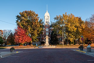
    Mount Ayr is a city in Ringgold County, Iowa, United States. The population was 1,988 at the time of the 2020 census. It is the county seat of Ringgold County. Mount Ayr is a rural community in southwestern Iowa, 22 miles west of Interstate 35 on State Highway 2. Mount Ayr was founded in 1875 and the community was named in honor of poet Robert Burns’ birthplace in Ayr, Scotland. The “mount” was added to indicate its location on the highest point of land in the area.

    <span class="mw-page-title-main">Tingley, Iowa</span> City in Iowa, United States

    Tingley is a city in northern Ringgold County, Iowa, United States. The population was 136 at the time of the 2020 census.

    <span class="mw-page-title-main">Scarville, Iowa</span> City in Iowa, United States

    Scarville is a city in Winnebago County, Iowa, United States. The population was 74 at the time of the 2020 census.

    <span class="mw-page-title-main">Whalan, Minnesota</span> City in Minnesota, United States

    Whalan is a city in Fillmore County, Minnesota, United States. The population was 63 at the 2010 census.

    <span class="mw-page-title-main">Clearfield, Iowa</span> City in Iowa, United States

    Clearfield is a city in Taylor and Ringgold counties in the U.S. state of Iowa. The population was 278 at the time of the 2020 census.

    <span class="mw-page-title-main">Shannon City, Iowa</span> City in Iowa, United States

    Shannon City is a city in southern Union and northern Ringgold counties in the U.S. state of Iowa. The population was 73 at the time of the 2020 census.

    References

    1. 1 2 3 "2020 Census State Redistricting Data". census.gov. United states Census Bureau. Retrieved August 12, 2021.
    2. "Find a County". National Association of Counties. Retrieved June 7, 2011.
    3. "US Gazetteer files: 2010, 2000, and 1990". United States Census Bureau. February 12, 2011. Retrieved April 23, 2011.
    4. "Annual Estimates of the Resident Population for Counties: April 1, 2020 to July 1, 2023". United States Census Bureau. Retrieved April 2, 2024.
    5. "U.S. Decennial Census". United States Census Bureau. Retrieved July 20, 2014.
    6. "Historical Census Browser". University of Virginia Library. Retrieved July 20, 2014.
    7. "Population of Counties by Decennial Census: 1900 to 1990". United States Census Bureau. Retrieved July 20, 2014.
    8. "Census 2000 PHC-T-4. Ranking Tables for Counties: 1990 and 2000" (PDF). United States Census Bureau. Archived (PDF) from the original on March 27, 2010. Retrieved July 20, 2014.
    9. "State & County QuickFacts". United States Census Bureau. Archived from the original on July 31, 2011. Retrieved July 20, 2014.
    10. "Population & Housing Occupancy Status 2010" (PDF). United States Census Bureau – American FactFinder. Archived (PDF) from the original on October 16, 2020. Retrieved August 15, 2022.
    11. "U.S. Census website". United States Census Bureau. Retrieved January 31, 2008.
    12. Leip, David. "Dave Leip's Atlas of U.S. Presidential Elections". uselectionatlas.org. Retrieved April 28, 2018.

    40°43′56″N94°14′53″W / 40.73222°N 94.24806°W / 40.73222; -94.24806