Shannon City, Iowa

Last updated
Shannon City, Iowa
Shannon City, IA.jpg
Union County Iowa Incorporated and Unincorporated areas Shannon City Highlighted.svg
Location of Shannon City, Iowa
Coordinates: 40°53′59″N94°15′50″W / 40.89972°N 94.26389°W / 40.89972; -94.26389 Coordinates: 40°53′59″N94°15′50″W / 40.89972°N 94.26389°W / 40.89972; -94.26389
Country Flag of the United States.svg  United States
State Flag of Iowa.svg  Iowa
Counties Union, Ringgold
Area
[1]
  Total0.41 sq mi (1.07 km2)
  Land0.41 sq mi (1.07 km2)
  Water0.00 sq mi (0.01 km2)
Elevation
[2]
1,224 ft (373 m)
Population
 (2020)
  Total73
  Density177.18/sq mi (68.47/km2)
Time zone UTC-6 (Central (CST))
  Summer (DST) UTC-5 (CDT)
ZIP code
50861
Area code 641
FIPS code 19-71940
GNIS feature ID0461528 [2]

Shannon City is a city in southern Union and northern Ringgold counties in the U.S. state of Iowa. The population was 73 at the time of the 2020 census. [3]

Contents

Geography

Shannon City is two miles west of US Route 169 along the Union-Ringgold County line. The Grand River flows past the southeast side of the community. [4]

According to the United States Census Bureau, the city has a total area of 0.41 square miles (1.06 km2), all land. [5]

Demographics

Historical populations
YearPop.±%
1900 380    
1910 292−23.2%
1920 333+14.0%
1930 293−12.0%
1940 288−1.7%
1950 171−40.6%
1960 127−25.7%
1970 100−21.3%
1980 93−7.0%
1990 97+4.3%
2000 70−27.8%
2010 71+1.4%
2020 73+2.8%
Source: "U.S. Census website". United States Census Bureau . Retrieved 2020-03-28. and Iowa Data Center
Source:
U.S. Decennial Census [6] [3]

2010 census

As of the census [7] of 2010, there were 71 people, 35 households, and 19 families living in the city. The population density was 173.2 inhabitants per square mile (66.9/km2). There were 41 housing units at an average density of 100.0 per square mile (38.6/km2). The racial makeup of the city was 98.6% White and 1.4% from two or more races. Hispanic or Latino of any race were 1.4% of the population.

There were 35 households, of which 22.9% had children under the age of 18 living with them, 31.4% were married couples living together, 5.7% had a female householder with no husband present, 17.1% had a male householder with no wife present, and 45.7% were non-families. 40.0% of all households were made up of individuals, and 20% had someone living alone who was 65 years of age or older. The average household size was 2.03 and the average family size was 2.58.

The median age in the city was 44.3 years. 22.5% of residents were under the age of 18; 2.8% were between the ages of 18 and 24; 26.7% were from 25 to 44; 29.6% were from 45 to 64; and 18.3% were 65 years of age or older. The gender makeup of the city was 59.2% male and 40.8% female.

2000 census

As of the census [8] of 2000, there were 70 people, 34 households, and 19 families living in the city. The population density was 470.6 inhabitants per square mile (181.7/km2). There were 40 housing units at an average density of 268.9 per square mile (103.8/km2). The racial makeup of the city was 97.14% White, 1.43% from other races, and 1.43% from two or more races.

There were 34 households, out of which 26.5% had children under the age of 18 living with them, 38.2% were married couples living together, 5.9% had a female householder with no husband present, and 44.1% were non-families. 38.2% of all households were made up of individuals, and 17.6% had someone living alone who was 65 years of age or older. The average household size was 2.06 and the average family size was 2.63.

In the city, the population was spread out, with 21.4% under the age of 18, 5.7% from 18 to 24, 34.3% from 25 to 44, 22.9% from 45 to 64, and 15.7% who were 65 years of age or older. The median age was 40 years. For every 100 females, there were 112.1 males. For every 100 females age 18 and over, there were 120.0 males.

The median income for a household in the city was $19,583, and the median income for a family was $23,750. Males had a median income of $19,063 versus $16,667 for females. The per capita income for the city was $10,554. There were 20.0% of families and 17.7% of the population living below the poverty line, including 12.0% of under eighteens and none of those over 64.

Related Research Articles

<span class="mw-page-title-main">Ringgold County, Iowa</span> County in Iowa, United States

Ringgold County is a county located in the U.S. state of Iowa. As of the 2020 census, the population was 4,663, making it the Iowa county with the second-smallest population. The county seat is Mount Ayr. The county is named after Maj. Samuel Ringgold, a hero of the Battle of Palo Alto fought in May 1846, during the Mexican–American War. It is one of the 26 Iowa counties with a name that is unique across the nation.

<span class="mw-page-title-main">Catoosa County, Georgia</span> County in Georgia, United States

Catoosa County is a county located in the northwestern part of the U.S. state of Georgia. As of the 2010 census, the population was 63,942. The county seat is Ringgold. The county was created on December 5, 1853. The meaning of the Cherokee language name "Catoosa" is obscure.

<span class="mw-page-title-main">Glencoe, Alabama</span> City in Alabama, United States

Glencoe is a city in Calhoun and Etowah counties in the U.S. state of Alabama. It is part of the Gadsden Metropolitan Statistical Area. The city incorporated in 1939. The population was 5,160 at the 2010 census.

<span class="mw-page-title-main">Minden, Iowa</span> City in Iowa, United States

Minden is a city in Pottawattamie County, Iowa, United States. The population was 600 at the time of the 2020 census. It has possessed a post office since 1875.

<span class="mw-page-title-main">Diagonal, Iowa</span> City in Iowa, United States

Diagonal is a city in northwest Ringgold County, Iowa, United States. The population was 344 at the time of the 2020 census.

<span class="mw-page-title-main">Kellerton, Iowa</span> City in Iowa, United States

Kellerton is a city in eastern Ringgold County, Iowa, United States. The population was 243 at the time of the 2020 census.

<span class="mw-page-title-main">Maloy, Iowa</span> City in Iowa, United States

Maloy is a city in southwest Ringgold County, Iowa, United States, along the Platte River. The population was 22 at the time of the 2020 census.

<span class="mw-page-title-main">Mount Ayr, Iowa</span> City in Iowa, United States

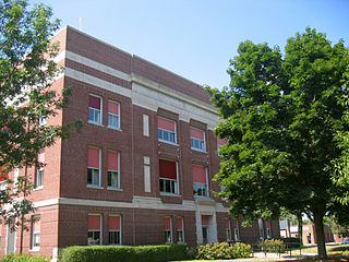
Mount Ayr is a city in Ringgold County, Iowa, United States. The population was 1,988 at the time of the 2020 census. It is the county seat of Ringgold County. Mount Ayr is a rural community in southwestern Iowa, 22 miles west of Interstate 35 on State Highway 2. Mount Ayr was founded in 1875 and the community was named in honor of poet Robert Burns’ birthplace in Ayr, Scotland. The “mount” was added to indicate its location on the highest point of land in the area.

<span class="mw-page-title-main">Redding, Iowa</span> City in Iowa, United States

Redding is a city in southwest Ringgold County, Iowa, United States. The population was 63 at the time of the 2020 census.

<span class="mw-page-title-main">Tingley, Iowa</span> City in Iowa, United States

Tingley is a city in northern Ringgold County, Iowa, United States. The population was 136 at the time of the 2020 census.

<span class="mw-page-title-main">Birch Tree, Missouri</span> City in Missouri, United States

Birch Tree is a city in southwest Shannon County, Missouri, United States. The population was 541 at the 2020 census.

<span class="mw-page-title-main">Eminence, Missouri</span> City in Missouri, United States

Eminence is a city in Shannon County, Missouri, United States. The population was 515 at the 2020 census. It is the county seat of Shannon County.

<span class="mw-page-title-main">Winona, Missouri</span> City in Missouri, United States

Winona is a city in southeast Shannon County, Missouri, United States. The population was 950 at the 2020 census.

<span class="mw-page-title-main">Coopersville, Michigan</span> City in Michigan, United States

Coopersville is a city located in north central Ottawa County in the U.S. state of Michigan. The population was 4,828 at the 2020 census. It is primarily a farming community.

<span class="mw-page-title-main">Clarkson Valley, Missouri</span> City in Missouri, United States

Clarkson Valley is a city in St. Louis County, Missouri, United States. The population was 2,609 at the 2020 census.

<span class="mw-page-title-main">Ringgold Township, Jefferson County, Pennsylvania</span> Township in Pennsylvania, United States

Ringgold Township is a township in Jefferson County, Pennsylvania, United States. The population was 771 at the 2020 census.

McKeansburg is a census-designated place (CDP) in Schuylkill County, Pennsylvania, United States. The population was 155 at the 2000 census.

<span class="mw-page-title-main">New Ringgold, Pennsylvania</span> Borough in Pennsylvania, United States

New Ringgold is a borough in Schuylkill County, Pennsylvania, United States. The population was 253 at the 2020 census.

<span class="mw-page-title-main">Clearfield, Iowa</span> City in Iowa, United States

Clearfield is a city in Taylor and Ringgold counties in the U.S. state of Iowa. The population was 278 at the time of the 2020 census.

<span class="mw-page-title-main">Summersville, Missouri</span> City in Missouri, United States

Summersville is a city in Shannon and Texas counties in the U.S. state of Missouri. The population was 453 at the 2020 census.

References

  1. "2020 U.S. Gazetteer Files". United States Census Bureau. Retrieved March 16, 2022.
  2. 1 2 U.S. Geological Survey Geographic Names Information System: Shannon City, Iowa
  3. 1 2 "2020 Census State Redistricting Data". census.gov. United states Census Bureau. Retrieved 12 August 2021.
  4. Iowa Atlas & Gazetteer, DeLorme, 7th Edition, 2021 p. 57 ISBN   1946494003
  5. "US Gazetteer files 2010". United States Census Bureau. Archived from the original on 2012-07-02. Retrieved 2012-05-11.
  6. "Census of Population and Housing". Census.gov. Retrieved June 4, 2015.
  7. "U.S. Census website". United States Census Bureau . Retrieved 2012-05-11.
  8. "U.S. Census website". United States Census Bureau . Retrieved 2008-01-31.