Benton, Iowa

Last updated

Benton, Iowa
Benton, IA.jpg
Ringgold County Iowa Incorporated and Unincorporated areas Benton Highlighted.svg
Location of Benton, Iowa
Coordinates: 40°42′17″N94°21′39″W / 40.70472°N 94.36083°W / 40.70472; -94.36083
Country Flag of the United States.svg  United States
State Flag of Iowa.svg  Iowa
County Ringgold
Government
  MayorDon Zollman
Area
[1]
  Total0.76 sq mi (1.97 km2)
  Land0.76 sq mi (1.96 km2)
  Water0.00 sq mi (0.01 km2)
Elevation
[2]
1,060 ft (320 m)
Population
 (2020)
  Total39
  Density51.52/sq mi (19.90/km2)
Time zone UTC-6 (Central (CST))
  Summer (DST) UTC-5 (CDT)
ZIP code
50835
Area code 641
FIPS code 19-05905
GNIS feature ID2394141 [2]

Benton is a city in Ringgold County, Iowa, United States. The population was 39 at the 2020 census. [3]

Contents

Geography

According to the United States Census Bureau, the city has a total area of 0.64 square miles (1.66 km2), all land. [4]

Demographics

Historical populations
YearPop.±%
1900 192    
1910 191−0.5%
1920 246+28.8%
1930 173−29.7%
1940 189+9.2%
1950 128−32.3%
1960 84−34.4%
1970 46−45.2%
1980 33−28.3%
1990 39+18.2%
2000 40+2.6%
2010 41+2.5%
2020 39−4.9%
Source: "U.S. Census website". United States Census Bureau . Retrieved March 28, 2020. and Iowa Data Center
Source:
U.S. Decennial Census [5] [3]
The population of Benton, Iowa from US census data BentonIowaPopPlot.png
The population of Benton, Iowa from US census data

2010 census

As of the census [6] of 2010, there were 41 people, 18 households, and 13 families living in the city. The population density was 64.1 inhabitants per square mile (24.7/km2). There were 21 housing units at an average density of 32.8 per square mile (12.7/km2). The racial makeup of the city was 95.1% White, 2.4% from other races, and 2.4% from two or more races. Hispanic or Latino of any race were 4.9% of the population.

There were 18 households, of which 16.7% had children under the age of 18 living with them, 72.2% were married couples living together, and 27.8% were non-families. 16.7% of all households were made up of individuals. The average household size was 2.28 and the average family size was 2.62.

The median age in the city was 53.5 years. 12.2% of residents were under the age of 18; 9.7% were between the ages of 18 and 24; 9.7% were from 25 to 44; 48.9% were from 45 to 64; and 19.5% were 65 years of age or older. The gender makeup of the city was 58.5% male and 41.5% female.

2000 census

As of the census [7] of 2000, there were 40 people, 19 households, and 14 families living in the city. The population density was 59.8 inhabitants per square mile (23.1/km2). There were 20 housing units at an average density of 29.9 per square mile (11.5/km2). The racial makeup of the city was 100.00% White. Hispanic or Latino of any race were 2.50% of the population.

There were 19 households, out of which 10.5% had children under the age of 18 living with them, 68.4% were married couples living together, and 26.3% were non-families. 26.3% of all households were made up of individuals, and 10.5% had someone living alone who was 65 years of age or older. The average household size was 2.11 and the average family size was 2.43.

In the city, the population was spread out, with 10.0% under the age of 18, 7.5% from 18 to 24, 22.5% from 25 to 44, 32.5% from 45 to 64, and 27.5% who were 65 years of age or older. The median age was 52 years. For every 100 females, there were 166.7 males. For every 100 females age 18 and over, there were 140.0 males.

The median income for a household in the city was $26,250, and the median income for a family was $29,375. Males had a median income of $16,875 versus $16,250 for females. The per capita income for the city was $15,752. None of the population and none of the families were below the poverty line.

Education

Mount Ayr Community School District operates public schools serving the community. [8]

Related Research Articles

<span class="mw-page-title-main">Pleasant Plain, Iowa</span> City in Iowa, United States

Pleasant Plain is a city in northeast Penn Township, Jefferson County, Iowa, United States. At the time of the 2020 census, the population was 84.

<span class="mw-page-title-main">Gibson, Iowa</span> City in Iowa, United States

Gibson is a city in Keokuk County, Iowa, United States. The population was 63 at the time of the 2020 census.

<span class="mw-page-title-main">Webster, Iowa</span> City in Iowa, United States

Webster is a city in Keokuk County, Iowa, United States. The population was 94 at the time of the 2020 census.

<span class="mw-page-title-main">Dixon, Iowa</span> City in Iowa, United States

Dixon is a city in Scott County, Iowa, United States. The population was 202 at the time of the 2020 census.

<span class="mw-page-title-main">Vining, Iowa</span> City in Iowa, United States

Vining is a city in Tama County, Iowa, United States. The population was 54 at the time of the 2020 census.

<span class="mw-page-title-main">Wolf Lake, Minnesota</span> City in Minnesota, United States

Wolf Lake is a city in Becker County, Minnesota, United States. The population was 71 at the 2020 census.

<span class="mw-page-title-main">Barry, Minnesota</span> City in Minnesota, United States

Barry is a city in northern Big Stone County, Minnesota, United States. The population was 16 at the 2020 census.

<span class="mw-page-title-main">Squaw Lake, Minnesota</span> City in Minnesota, United States

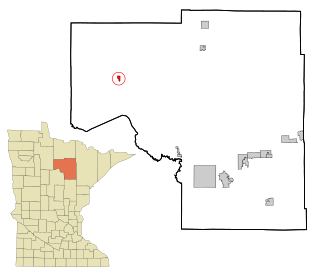
Squaw Lake is a city in Itasca County, Minnesota, United States. The population was 107 at the 2010 census.

<span class="mw-page-title-main">Erhard, Minnesota</span> City in Minnesota, United States

Erhard is a city in Otter Tail County, Minnesota, United States. The population was 132 at the 2020 census.

<span class="mw-page-title-main">Henning, Minnesota</span> City in Minnesota, United States

Henning is a city in Otter Tail County, Minnesota, United States. The population was 854 at the 2020 census.

<span class="mw-page-title-main">Urbank, Minnesota</span> City in Minnesota, United States

Urbank is a city in Otter Tail County, Minnesota, United States. The population was 52 at the 2020 census.

<span class="mw-page-title-main">Leonidas, Minnesota</span> City in Minnesota, United States

Leonidas is a city in Saint Louis County, Minnesota, United States. The population was 52 at the 2010 census.

<span class="mw-page-title-main">Goodview, Minnesota</span> City in Minnesota, United States

Goodview is a city in Winona County, Minnesota, United States. The population was 4,158 at the 2020 census.

<span class="mw-page-title-main">Cave, Missouri</span> Populated Place in Missouri, United States

Cave is a populated place in Lincoln County, Missouri, United States. The population was 5 at the 2010 census. With a 2020 population of 5, it is the 939th largest city in Missouri and the 19481st largest city in the United States. Cave is currently declining at a rate of 0.00% annually and its population has decreased by 0.00% since the most recent census, which recorded a population of 5 in 2010.

<span class="mw-page-title-main">Rogers, North Dakota</span> City in North Dakota, United States

Rogers is a city in Barnes County, North Dakota, United States. The population was 49 at the 2020 census. Rogers was founded in 1897.

<span class="mw-page-title-main">Kramer, North Dakota</span> City in North Dakota, United States

Kramer is a city in Bottineau County, North Dakota, United States. The population was 24 at the 2020 census. Kramer was founded in 1905.

<span class="mw-page-title-main">North River, North Dakota</span> City in North Dakota, United States

North River is a city in Cass County, North Dakota, United States. The population was 55 at the 2020 census. North River was founded in 1973. It is a suburb/bedroom community directly adjacent to the city of Fargo.

<span class="mw-page-title-main">War, West Virginia</span> City in West Virginia, United States

War is a city in McDowell County, West Virginia, United States. The population was 690 at the 2020 census. War was incorporated in 1920 by the Circuit Court of McDowell County. Its name is derived from War Creek, whose confluence with Dry Fork is located within the city. War is the only place in the United States with this name. War was formerly known as Miner's City. It is also known for being a setting in the movie October Sky; as writer Homer Hickam's Big Creek High School.

<span class="mw-page-title-main">Bancroft, West Virginia</span> Town in West Virginia, United States

Bancroft is a town in Putnam County, West Virginia, United States, along the Kanawha River. The population was 389 at the 2020 census. It is part of the Huntington–Ashland metropolitan area.

<span class="mw-page-title-main">Minneiska, Minnesota</span> City in Minnesota, United States

Minneiska is a city in Wabasha and Winona counties in the U.S. state of Minnesota. The population was 111 at the 2010 census.

References

  1. "2020 U.S. Gazetteer Files". United States Census Bureau. Retrieved March 16, 2022.
  2. 1 2 U.S. Geological Survey Geographic Names Information System: Benton, Iowa
  3. 1 2 "2020 Census State Redistricting Data". census.gov. United states Census Bureau. Retrieved August 12, 2021.
  4. "US Gazetteer files 2010". United States Census Bureau. Archived from the original on July 2, 2012. Retrieved May 11, 2012.
  5. "Census of Population and Housing". Census.gov. Retrieved June 4, 2015.
  6. "U.S. Census website". United States Census Bureau . Retrieved May 11, 2012.
  7. "U.S. Census website". United States Census Bureau . Retrieved January 31, 2008.
  8. "Mount Ayr Archived April 27, 2018, at the Wayback Machine ." Iowa Department of Education. Retrieved on June 21, 2018.