Thayer, Iowa

Last updated
Thayer, Iowa
Union County Iowa Incorporated and Unincorporated areas Thayer Highlighted.svg
Location of Thayer, Iowa
Coordinates: 41°1′45″N94°2′59″W / 41.02917°N 94.04972°W / 41.02917; -94.04972 Coordinates: 41°1′45″N94°2′59″W / 41.02917°N 94.04972°W / 41.02917; -94.04972
Country Flag of the United States.svg  United States
State Flag of Iowa.svg  Iowa
County Union
Area
[1]
  Total0.14 sq mi (0.37 km2)
  Land0.14 sq mi (0.37 km2)
  Water0.00 sq mi (0.00 km2)
Elevation
1,106 ft (337 m)
Population
 (2020)
  Total51
  Density356.64/sq mi (138.15/km2)
Time zone UTC-6 (Central (CST))
  Summer (DST) UTC-5 (CDT)
ZIP code
50254
Area code 641
FIPS code 19-77565
GNIS feature ID0462202

Thayer is a city in Union County, Iowa, United States. The population was 51 at the time of the 2020 census. [2]

Contents

Geography

Thayer is located at 41°1'45" North, 94°2'59" West (41.029242, -94.049856). [3]

According to the United States Census Bureau, the city has a total area of 0.09 square miles (0.23 km2), all land. [4]

Demographics

Historical populations
YearPop.±%
1900 394    
1910 198−49.7%
1920 260+31.3%
1930 164−36.9%
1940 157−4.3%
1950 152−3.2%
1960 101−33.6%
1970 100−1.0%
1980 87−13.0%
1990 79−9.2%
2000 66−16.5%
2010 59−10.6%
2020 51−13.6%
Source: "U.S. Census website". United States Census Bureau . Retrieved 2020-03-29. and Iowa Data Center
Source:
U.S. Decennial Census [5] [2]

2010 census

As of the census [6] of 2010, there were 59 people, 24 households, and 15 families residing in the city. The population density was 655.6 inhabitants per square mile (253.1/km2). There were 29 housing units at an average density of 322.2 per square mile (124.4/km2). The racial makeup of the city was 100.0% White.

There were 24 households, of which 37.5% had children under the age of 18 living with them, 37.5% were married couples living together, 4.2% had a female householder with no husband present, 20.8% had a male householder with no wife present, and 37.5% were non-families. 33.3% of all households were made up of individuals, and 4.2% had someone living alone who was 65 years of age or older. The average household size was 2.46 and the average family size was 3.00.

The median age in the city was 36.5 years. 25.4% of residents were under the age of 18; 10.3% were between the ages of 18 and 24; 37.3% were from 25 to 44; 18.7% were from 45 to 64; and 8.5% were 65 years of age or older. The gender makeup of the city was 57.6% male and 42.4% female.

2000 census

As of the census [7] of 2000, there were 66 people, 26 households, and 15 families residing in the city. The population density was 672.7 inhabitants per square mile (259.7/km2). There were 35 housing units at an average density of 356.7 per square mile (137.7/km2). The racial makeup of the city was 96.97% White and 3.03% Native American.

There were 26 households, out of which 26.9% had children under the age of 18 living with them, 46.2% were married couples living together, none had a female householder with no husband present, and 38.5% were non-families. 26.9% of all households were made up of individuals, and 15.4% had someone living alone who was 65 years of age or older. The average household size was 2.54 and the average family size was 3.06.

In the city, the population was spread out, with 25.8% under the age of 18, 12.1% from 18 to 24, 33.3% from 25 to 44, 18.2% from 45 to 64, and 10.6% who were 65 years of age or older. The median age was 33 years. For every 100 females, there were 112.9 males. For every 100 females age 18 and over, there were 104.2 males.

The median income for a household in the city was $31,250, and the median income for a family was $38,750. Males had a median income of $21,667 versus $12,500 for females. The per capita income for the city was $13,705. 6.3% of the population but no families were below the poverty line. Out of the total population, none of those under the age of 18 and 25.0% of those 65 and older were living below the poverty line.

See also

Related Research Articles

<span class="mw-page-title-main">Harpers Ferry, Iowa</span> City in Iowa, United States

Harpers Ferry is a city in Taylor Township, Allamakee County, Iowa, United States. The population was 262 at the time of the 2020 census.

<span class="mw-page-title-main">Rembrandt, Iowa</span> City in Iowa, United States

Rembrandt is a city in Buena Vista County, Iowa, United States. The population was 209 at the time of the 2020 census.

<span class="mw-page-title-main">Maynard, Iowa</span> City in Iowa, United States

Maynard is a city in Fayette County, Iowa, United States. The population was 476 at the time of the 2020 census.

<span class="mw-page-title-main">Little Sioux, Iowa</span> City in Iowa, United States

Little Sioux is a city in Harrison County, Iowa, United States. The population was 166 at the time of the 2020 census. The city is most known for Little Sioux Scout Ranch of the Boy Scouts of America.

<span class="mw-page-title-main">Webster, Iowa</span> City in Iowa, United States

Webster is a city in Keokuk County, Iowa, United States. The population was 94 at the time of the 2020 census.

<span class="mw-page-title-main">Minden, Iowa</span> City in Iowa, United States

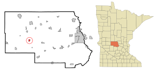
Minden is a city in Pottawattamie County, Iowa, United States. The population was 600 at the time of the 2020 census. It has possessed a post office since 1875.

<span class="mw-page-title-main">Dixon, Iowa</span> City in Iowa, USA

Dixon is a city in Scott County, Iowa, United States. The population was 202 at the time of the 2020 census.

<span class="mw-page-title-main">Maysville, Iowa</span> City in Iowa, USA

Maysville is a city in Scott County, Iowa, United States. The population was 156 at the time of the 2020 census.

<span class="mw-page-title-main">New Liberty, Iowa</span> City in Iowa, USA

New Liberty is a city in Scott County, Iowa, United States. The population was 138 at the time of the 2020 census.

<span class="mw-page-title-main">Olivet, Michigan</span> City in Michigan, United States

Olivet is a city in Eaton County in the U.S. state of Michigan. The population was 1,605 at the 2010 census. Olivet College is located in the city.

<span class="mw-page-title-main">Lilydale, Minnesota</span> City in Minnesota, United States

Lilydale is a city in Dakota County, Minnesota, United States. The population was 623 at the 2010 census.

<span class="mw-page-title-main">Warba, Minnesota</span> City in Minnesota, United States

Warba is a city in Itasca County, Minnesota, United States. The population was 181 at the 2010 census.

<span class="mw-page-title-main">Harding, Minnesota</span> City in Minnesota, United States

Harding is a city in Morrison County, Minnesota, United States, along the Platte River. The population was 123 at the 2020 census.

<span class="mw-page-title-main">Shelly, Minnesota</span> City in Minnesota, United States

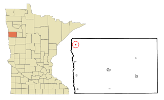
Shelly is a city in Norman County, Minnesota, United States. The population was 179 at the 2020 census.

<span class="mw-page-title-main">Bluffton, Minnesota</span> City in Minnesota, United States

Bluffton is a city in Otter Tail County, Minnesota, United States, along the Leaf River. The population was 210 at the 2020 census.

<span class="mw-page-title-main">Erhard, Minnesota</span> City in Minnesota, United States

Erhard is a city in Otter Tail County, Minnesota, United States. The population was 132 at the 2020 census.

<span class="mw-page-title-main">Flordell Hills, Missouri</span> City in Missouri, United States

Flordell Hills is a city in St. Louis County, Missouri, United States. The population was 822 at the 2010 census.

<span class="mw-page-title-main">Spring Hill, Minnesota</span> City in Minnesota, United States

Spring Hill is a city in Stearns County, Minnesota, United States. The population was 85 at the 2010 census. It is part of the St. Cloud Metropolitan Statistical Area.

<span class="mw-page-title-main">Clarkson Valley, Missouri</span> City in Missouri, United States

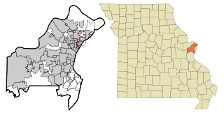
Clarkson Valley is a city in St. Louis County, Missouri, United States. The population was 2,609 at the 2020 census.

<span class="mw-page-title-main">Kramer, North Dakota</span> City in North Dakota, United States

Kramer is a city in Bottineau County, North Dakota, United States. The population was 24 at the 2020 census. Kramer was founded in 1905.

References

  1. "2020 U.S. Gazetteer Files". United States Census Bureau. Retrieved March 16, 2022.
  2. 1 2 "2020 Census State Redistricting Data". census.gov. United states Census Bureau. Retrieved 12 August 2021.
  3. "US Gazetteer files: 2010, 2000, and 1990". United States Census Bureau. 2011-02-12. Retrieved 2011-04-23.
  4. "US Gazetteer files 2010". United States Census Bureau. Archived from the original on 2012-01-25. Retrieved 2012-05-11.
  5. "Census of Population and Housing". Census.gov. Retrieved June 4, 2015.
  6. "U.S. Census website". United States Census Bureau . Retrieved 2012-05-11.
  7. "U.S. Census website". United States Census Bureau . Retrieved 2008-01-31.