Lorimor, Iowa

Last updated
Lorimor, Iowa
Lorimor, Iowa 003.jpg
City Hall
Union County Iowa Incorporated and Unincorporated areas Lorimor Highlighted.svg
Location of Lorimor, Iowa
Coordinates: 41°7′35″N94°3′21″W / 41.12639°N 94.05583°W / 41.12639; -94.05583 Coordinates: 41°7′35″N94°3′21″W / 41.12639°N 94.05583°W / 41.12639; -94.05583
Country Flag of the United States.svg  United States
State Flag of Iowa.svg  Iowa
County Union
Area
[1]
  Total0.43 sq mi (1.12 km2)
  Land0.43 sq mi (1.12 km2)
  Water0.00 sq mi (0.00 km2)
Elevation
1,224 ft (373 m)
Population
 (2020)
  Total386
  Density895.59/sq mi (345.44/km2)
Time zone UTC-6 (Central (CST))
  Summer (DST) UTC-5 (CDT)
ZIP code
50149
Area code 641
FIPS code 19-46515
GNIS feature ID0458617

Lorimor is a city in Union County, Iowa, United States. The population was 386 at the time of the 2020 census. [2]

Contents

History

Lorimor was founded by J.S. Lorimor, who was given the honor of renaming the city, when the town grew after he gave land to the railroads as they traveled through town, in return for the railroad placing a water stop in the town. With the business from the railroads, and his 2,000-acre (8.1 km2) farm of bluegrass seed, the town was quite successful in its early years.

Geography

According to the United States Census Bureau, the city has a total area of 0.38 square miles (0.98 km2), all land. [3]

Demographics

Historical populations
YearPop.±%
1900 587    
1910 645+9.9%
1920 678+5.1%
1930 577−14.9%
1940 614+6.4%
1950 505−17.8%
1960 460−8.9%
1970 346−24.8%
1980 405+17.1%
1990 377−6.9%
2000 427+13.3%
2010 360−15.7%
2020 386+7.2%
Source: "U.S. Census website". United States Census Bureau . Retrieved 2020-03-29. and Iowa Data Center
Source:
U.S. Decennial Census [4] [2]

2010 census

As of the census [5] of 2010, there were 360 people, 160 households, and 104 families residing in the city. The population density was 947.4 inhabitants per square mile (365.8/km2). There were 211 housing units at an average density of 555.3 per square mile (214.4/km2). The racial makeup of the city was 98.1% White, 0.3% African American, 0.8% Native American, and 0.8% from two or more races. Hispanic or Latino of any race were 0.8% of the population.

There were 160 households, of which 28.8% had children under the age of 18 living with them, 43.8% were married couples living together, 13.8% had a female householder with no husband present, 7.5% had a male householder with no wife present, and 35.0% were non-families. 31.3% of all households were made up of individuals, and 13.1% had someone living alone who was 65 years of age or older. The average household size was 2.25 and the average family size was 2.72.

The median age in the city was 42.2 years. 22.5% of residents were under the age of 18; 7.5% were between the ages of 18 and 24; 24.1% were from 25 to 44; 29.6% were from 45 to 64; and 16.4% were 65 years of age or older. The gender makeup of the city was 45.8% male and 54.2% female.

2000 census

As of the census [6] of 2000, there were 427 people, 176 households, and 114 families residing in the city. The population density was 1,055.2 inhabitants per square mile (407.4/km2). There were 188 housing units at an average density of 464.6 per square mile (179.4/km2). The racial makeup of the city was 98.83% White, 0.23% Native American, 0.47% Asian, and 0.47% from two or more races. Hispanic or Latino of any race were 0.47% of the population.

There were 176 households, out of which 31.3% had children under the age of 18 living with them, 51.7% were married couples living together, 10.8% had a female householder with no husband present, and 34.7% were non-families. 27.8% of all households were made up of individuals, and 13.1% had someone living alone who was 65 years of age or older. The average household size was 2.43 and the average family size was 2.99.

In the city, the population was spread out, with 28.3% under the age of 18, 8.0% from 18 to 24, 27.4% from 25 to 44, 21.8% from 45 to 64, and 14.5% who were 65 years of age or older. The median age was 35 years. For every 100 females, there were 92.3 males. For every 100 females age 18 and over, there were 90.1 males.

The median income for a household in the city was $28,636, and the median income for a family was $30,500. Males had a median income of $26,071 versus $20,179 for females. The per capita income for the city was $12,713. About 13.2% of families and 18.9% of the population were below the poverty line, including 31.9% of those under age 18 and 11.8% of those age 65 or over.

Related Research Articles

<span class="mw-page-title-main">Rembrandt, Iowa</span> City in Iowa, United States

Rembrandt is a city in Buena Vista County, Iowa, United States. The population was 209 at the time of the 2020 census.

<span class="mw-page-title-main">Webster, Iowa</span> City in Iowa, United States

Webster is a city in Keokuk County, Iowa, United States. The population was 94 at the time of the 2020 census.

<span class="mw-page-title-main">Minden, Iowa</span> City in Iowa, United States

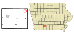
Minden is a city in Pottawattamie County, Iowa, United States. The population was 600 at the time of the 2020 census. It has possessed a post office since 1875.

<span class="mw-page-title-main">Dixon, Iowa</span> City in Iowa, USA

Dixon is a city in Scott County, Iowa, United States. The population was 202 at the time of the 2020 census.

<span class="mw-page-title-main">Maysville, Iowa</span> City in Iowa, USA

Maysville is a city in Scott County, Iowa, United States. The population was 156 at the time of the 2020 census.

<span class="mw-page-title-main">Woodland Hills, Kentucky</span> City in Kentucky, United States

Woodland Hills is a home rule-class city in Jefferson County, Kentucky, United States. The population was 696 at the 2010 census.

<span class="mw-page-title-main">Chickamaw Beach, Minnesota</span> City in Minnesota, United States

Chickamaw Beach is a city in Cass County, Minnesota, United States. The population was 114 at the 2010 census. It is part of the Brainerd Micropolitan Statistical Area.

<span class="mw-page-title-main">Warba, Minnesota</span> City in Minnesota, United States

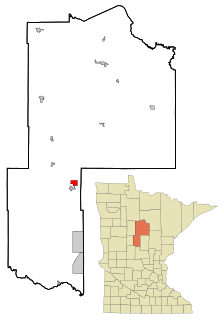
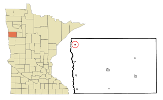
Warba is a city in Itasca County, Minnesota, United States. The population was 181 at the 2010 census.

<span class="mw-page-title-main">Shelly, Minnesota</span> City in Minnesota, United States

Shelly is a city in Norman County, Minnesota, United States. The population was 179 at the 2020 census.

<span class="mw-page-title-main">Bluffton, Minnesota</span> City in Minnesota, United States

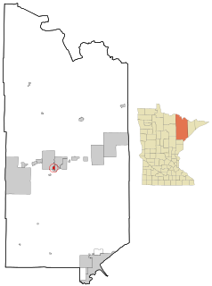
Bluffton is a city in Otter Tail County, Minnesota, United States, along the Leaf River. The population was 210 at the 2020 census.

<span class="mw-page-title-main">Erhard, Minnesota</span> City in Minnesota, United States

Erhard is a city in Otter Tail County, Minnesota, United States. The population was 132 at the 2020 census.

<span class="mw-page-title-main">Leonidas, Minnesota</span> City in Minnesota, United States

Leonidas is a city in Saint Louis County, Minnesota, United States. The population was 52 at the 2010 census.

<span class="mw-page-title-main">St. Rosa, Minnesota</span> City in Minnesota, United States

Saint Rosa is a city in Stearns County, Minnesota, United States. The population was 68 at the 2010 census. It is part of the St. Cloud Metropolitan Statistical Area.

<span class="mw-page-title-main">Fifty Lakes, Minnesota</span> City in Minnesota, United States

Fifty Lakes is a city in Crow Wing County, Minnesota, United States. The population was 387 at the 2010 census. It is part of the Brainerd Micropolitan Statistical Area.

<span class="mw-page-title-main">Clarkson Valley, Missouri</span> City in Missouri, United States

Clarkson Valley is a city in St. Louis County, Missouri, United States. The population was 2,609 at the 2020 census.

<span class="mw-page-title-main">Kramer, North Dakota</span> City in North Dakota, United States

Kramer is a city in Bottineau County, North Dakota, United States. The population was 24 at the 2020 census. Kramer was founded in 1905.

<span class="mw-page-title-main">Follansbee, West Virginia</span> City in West Virginia, United States

Follansbee is a city in Brooke County, West Virginia, United States, located along the Ohio River. It is a part of the Weirton–Steubenville metropolitan area. The population was 2,853 at the 2020 census, a decrease from 2,986 at the 2010 census.

<span class="mw-page-title-main">Stonewood, West Virginia</span> City in West Virginia, United States

Stonewood is a city in Harrison County, West Virginia, United States. The population was 1,810 at the 2020 census.

<span class="mw-page-title-main">Pennsboro, West Virginia</span> City in West Virginia, United States

Pennsboro is a city in Ritchie County, West Virginia, United States. The population was 1,050 at the 2020 census. The city is located at the junction of U.S. Route 50 and West Virginia Route 74; the North Bend Rail Trail also passes through the city.

<span class="mw-page-title-main">Minneiska, Minnesota</span> City in Minnesota, United States

Minneiska is a city in Wabasha and Winona counties in the U.S. state of Minnesota. The population was 111 at the 2010 census.

References

  1. "2020 U.S. Gazetteer Files". United States Census Bureau. Retrieved March 16, 2022.
  2. 1 2 "2020 Census State Redistricting Data". census.gov. United states Census Bureau. Retrieved 12 August 2021.
  3. "US Gazetteer files 2010". United States Census Bureau. Archived from the original on 2012-07-02. Retrieved 2012-05-11.
  4. "Census of Population and Housing". Census.gov. Retrieved June 4, 2015.
  5. "U.S. Census website". United States Census Bureau . Retrieved 2012-05-11.
  6. "U.S. Census website". United States Census Bureau . Retrieved 2008-01-31.