Hamilton County, Iowa

Last updated

Hamilton County
Hamilton County IA Courthouse.jpg
Map of Iowa highlighting Hamilton County.svg
Location within the U.S. state of Iowa
Iowa in United States.svg
Iowa's location within the U.S.
Coordinates: 42°22′55″N93°42′39″W / 42.381944444444°N 93.710833333333°W / 42.381944444444; -93.710833333333
CountryFlag of the United States.svg United States
StateFlag of Iowa.svg  Iowa
Founded1856
Named for William W. Hamilton
Seat Webster City
Largest cityWebster City
Area
  Total578 sq mi (1,500 km2)
  Land577 sq mi (1,490 km2)
  Water0.8 sq mi (2 km2)  0.1%
Population
 (2020)
  Total15,039
  Density26/sq mi (10/km2)
Time zone UTC−6 (Central)
  Summer (DST) UTC−5 (CDT)
Congressional district 4th
Website www.hamiltoncounty.iowa.gov

Hamilton County is a county located in the U.S. state of Iowa. As of the 2020 census, the population was 15,039. [1] The county seat is Webster City. [2] The county was named to honor William W. Hamilton, a President of the Iowa State Senate. [3]

Contents

Geography

According to the U.S. Census Bureau, the county has a total area of 578 square miles (1,500 km2), of which 577 square miles (1,490 km2) is land and 0.8 square miles (2.1 km2) (0.1%) is water. [4] The largest body of water is Little Wall Lake.

Major highways

Transit

Adjacent counties

Demographics

Historical population
CensusPop.Note
1860 1,699
1870 6,055256.4%
1880 11,25285.8%
1890 15,31936.1%
1900 19,51427.4%
1910 19,242−1.4%
1920 19,5311.5%
1930 20,9787.4%
1940 19,922−5.0%
1950 19,660−1.3%
1960 20,0321.9%
1970 18,383−8.2%
1980 17,862−2.8%
1990 16,071−10.0%
2000 16,4382.3%
2010 15,673−4.7%
2020 15,039−4.0%
2023 (est.)14,729 [5] −2.1%
U.S. Decennial Census [6]
1790-1960 [7] 1900-1990 [8]
1990-2000 [9] 2010-2018 [10]
Population of Hamilton County from US census data HamiltonCountyIowaPop2020.png
Population of Hamilton County from US census data

2020 census

2022 US Census population pyramid for Hamilton County from ACS 5-year estimates HamiltonCountyIA2022PopPyr.png
2022 US Census population pyramid for Hamilton County from ACS 5-year estimates

The 2020 census recorded a population of 15,039 in the county, with a population density of

Hamilton County Racial Composition [11]
RaceNum.Perc.
White (NH)12,70284.46%
Black or African American (NH)880.6%
Native American (NH)250.16%
Asian (NH)3142.1%
Pacific Islander (NH)00%
Other/Mixed (NH)4453%
Hispanic or Latino 1,4659.74%

2010 census

The 2010 census recorded a population of 15,673 in the county, with a population density of

2000 census

As of the census [13] of 2000, there were 16,438 people, 6,692 households, and 4,597 families residing in the county. The population density was 28 people per square mile (11 people/km2). There were 7,082 housing units at an average density of 12 units per square mile (4.6 units/km2). The racial makeup of the county was 96.71% White, 0.23% Black or African American, 0.20% Native American, 1.46% Asian, 0.01% Pacific Islander, 0.61% from other races, and 0.78% from two or more races. 1.42% of the population were Hispanic or Latino of any race.

There were 6,692 households, out of which 30.60% had children under the age of 18 living with them, 57.90% were married couples living together, 7.60% had a female householder with no husband present, and 31.30% were non-families. 27.50% of all households were made up of individuals, and 13.60% had someone living alone who was 65 years of age or older. The average household size was 2.43 and the average family size was 2.95.

In the county, the population was spread out, with 25.40% under the age of 18, 7.10% from 18 to 24, 27.10% from 25 to 44, 22.40% from 45 to 64, and 18.00% who were 65 years of age or older. The median age was 39 years. For every 100 females there were 98.00 males. For every 100 females age 18 and over, there were 94.80 males.

The median income for a household in the county was $38,658, and the median income for a family was $45,771. Males had a median income of $30,579 versus $23,595 for females. The per capita income for the county was $18,801. About 4.30% of families and 6.30% of the population were below the poverty line, including 7.70% of those under age 18 and 5.50% of those age 65 or over.

Communities

Cities

Unincorporated communities

Townships

Source: [15]

Population ranking

The population ranking of the following table is based on the 2020 census of Hamilton County. [1]

county seat

RankCity/Town/etc.Municipal typePopulation (2020 Census)
1 Webster City City7,825
2 Jewell Junction City1,216
3 Stratford (partially in Webster County )City707
4 Ellsworth City508
5 Stanhope City364
6 Williams City307
7 Kamrar City179
8 Blairsburg City176
9 Randall City154

Politics

Hamilton County has been a swing county for most of its history. In the last 100 years, it has backed the losing candidate nationally only four times in the 1960, 1988, 2012 and 2020 presidential elections.

United States presidential election results for Hamilton County, Iowa [16]
Year Republican Democratic Third party
No.%No.%No.%
2020 4,95662.39%2,84335.79%1441.81%
2016 4,46358.01%2,72635.43%5056.56%
2012 3,99150.35%3,78247.71%1541.94%
2008 3,91348.42%4,01849.72%1501.86%
2004 4,36752.39%3,89546.73%730.88%
2000 3,96852.39%3,40744.98%1992.63%
1996 3,10942.72%3,45547.48%7139.80%
1992 3,03139.46%3,26242.47%1,38818.07%
1988 3,27743.73%4,15655.46%610.81%
1984 4,27955.61%3,33043.27%861.12%
1980 4,74557.40%2,74133.16%7809.44%
1976 3,93249.00%3,95349.26%1401.74%
1972 4,80360.87%2,91336.92%1742.21%
1968 4,60757.58%3,05838.22%3364.20%
1964 3,12737.53%5,19562.35%100.12%
1960 5,26557.39%3,90542.57%40.04%
1956 5,66759.56%3,82940.25%180.19%
1952 7,00671.29%2,78828.37%340.35%
1948 3,53548.13%3,61349.19%1972.68%
1944 3,83746.91%4,30252.59%410.50%
1940 4,18344.03%5,27955.56%390.41%
1936 3,17436.24%5,43262.02%1521.74%
1932 2,33030.56%5,19168.09%1031.35%
1928 4,17158.01%2,97541.38%440.61%
1924 4,40160.74%4906.76%2,35532.50%
1920 5,92482.88%1,12615.75%981.37%
1916 3,03770.94%1,12526.28%1192.78%
1912 83119.37%1,04124.27%2,41856.36%
1908 2,76568.17%1,14528.23%1463.60%
1904 3,11877.08%74618.44%1814.47%
1900 3,25973.15%1,13425.45%621.39%
1896 3,07469.25%1,30029.29%651.46%

Education

School districts include: [17]

Former school districts:

See also

Related Research Articles

<span class="mw-page-title-main">Wright County, Iowa</span> County in Iowa, United States

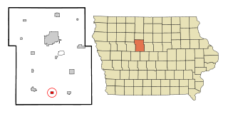
Wright County is a county in the U.S. state of Iowa. As of the 2020 census, the population was 12,943. The county seat is Clarion. The county organization became effective in January 1851, and is believed to be named either after Silas Wright, a governor of New York, or Joseph Albert Wright, a governor of Indiana.

<span class="mw-page-title-main">Webster County, Iowa</span> County in Iowa, United States

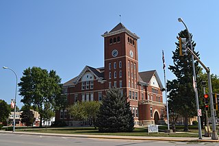
Webster County is a county in the U.S. state of Iowa. As of the 2020 census, the population was 36,999. The county seat is Fort Dodge. The county was established in January 1851, one of 43 counties established by a legislative package. This county was named after Daniel Webster, an American statesman noted for his moving oratory.

<span class="mw-page-title-main">Shellsburg, Iowa</span> City in Iowa, United States

Shellsburg is a city in Benton County, Iowa, United States. The population was 961 at the time of the 2020 census. It is part of the Cedar Rapids Metropolitan Statistical Area.

<span class="mw-page-title-main">Boxholm, Iowa</span> City in Iowa, United States

Boxholm is a city in Grant Township, Boone County, Iowa, United States. The population was 181 at the 2020 census. It is part of the Boone, Iowa Micropolitan Statistical Area, which is a part of the larger Ames-Boone, Iowa Combined Statistical Area.

<span class="mw-page-title-main">Pilot Mound, Iowa</span> City in Iowa, United States

Pilot Mound is a city in Pilot Mound Township, Boone County, Iowa, United States. The population was 163 at the time of the 2020 census. It is part of the Boone, Iowa Micropolitan Statistical Area, which is a part of the larger Ames-Boone, Iowa Combined Statistical Area.

<span class="mw-page-title-main">Mechanicsville, Iowa</span> City in Iowa, United States

Mechanicsville is a city in Cedar County, Iowa, United States. The population was 1,020 at the time of the 2020 census.

<span class="mw-page-title-main">Stanwood, Iowa</span> City in Iowa, United States

Stanwood is a city in Cedar County, Iowa, United States. The population was 637 at the time of the 2020 census.

<span class="mw-page-title-main">Tipton, Iowa</span> City in Iowa, United States

Tipton (/ˈtɪptən/) is a city in Cedar County, Iowa, United States. The population was 3,149 at the time of the 2020 census. It is the county seat of Cedar County.

<span class="mw-page-title-main">Dow City, Iowa</span> City in Iowa, United States

Dow City is a city in Crawford County, Iowa, United States, along the Boyer River. The population was 485 at the time of the 2020 census.

<span class="mw-page-title-main">Wellsburg, Iowa</span> City in Iowa, United States

Wellsburg is a city in Grundy County, Iowa, United States. The population was 720 at the 2020 census, a slight increase from 716 in 2000. It is part of the Waterloo–Cedar Falls Metropolitan Statistical Area. The city is named for George Wells, an early settler in the region.

<span class="mw-page-title-main">Blairsburg, Iowa</span> City in Iowa, United States

Blairsburg is a city in Hamilton County, Iowa, United States. The population was 176 at the 2020 census.

<span class="mw-page-title-main">Kamrar, Iowa</span> City in Iowa, United States

Kamrar is a city in Hamilton County, Iowa, United States. The population was 179 at the time of the 2020 census.

<span class="mw-page-title-main">Williams, Iowa</span> City in Iowa, United States

Williams is a city in Hamilton County, Iowa, United States. The population was 307 at the time of the 2020 census. Williams is a regional center of wind power generation.

<span class="mw-page-title-main">Lone Rock, Iowa</span> City in Iowa, United States

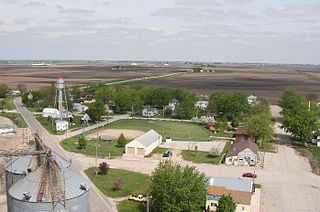
Lone Rock is a city in Kossuth County, Iowa, United States. The population was 146 at the time of the 2020 census. The city is named after a large boulder.

<i>Dysart, Iowa</i> City in Iowa, United States

Dysart is a city in Tama County, Iowa, United States. The population was 1,281 at the 2020 census. The Mayor of Dysart is currently Tim Glenn.

<span class="mw-page-title-main">Leando, Iowa</span> CDP in Iowa, United States

Leando is a census-designated place (CDP) in Van Buren County, Iowa, United States. The population was 135 at the 2000 census.

<span class="mw-page-title-main">Badger, Iowa</span> City in Iowa, United States

Badger is a Town in Webster County, Iowa, United States. The population was 522 at the 2020 census. The town got its name from Badger Creek, which itself got its name when a group of soldiers from Fort Dodge in the early 1850s saw a badger for the first time.

<span class="mw-page-title-main">Dayton, Iowa</span> City in Iowa, United States

Dayton is a city in Webster County, Iowa, United States. The population was 772 at the time of the 2020 census.

<span class="mw-page-title-main">Harcourt, Iowa</span> City in Iowa, United States

Harcourt is a city in Webster County, Iowa, United States. The population was 264 at the time of the 2020 census.

<span class="mw-page-title-main">Lehigh, Iowa</span> City in Iowa, United States

Lehigh is a city in Webster County, Iowa, United States. The population was 395 at the time of the 2020 census.

References

  1. 1 2 3 "2020 Census State Redistricting Data". census.gov. United states Census Bureau. Retrieved August 12, 2021.
  2. "Find a County". National Association of Counties. Retrieved June 7, 2011.
  3. Gannett, Henry (1905). The Origin of Certain Place Names in the United States. Govt. Print. Off. p.  148.
  4. "US Gazetteer files: 2010, 2000, and 1990". United States Census Bureau. February 12, 2011. Retrieved April 23, 2011.
  5. "Annual Estimates of the Resident Population for Counties: April 1, 2020 to July 1, 2023". United States Census Bureau. Retrieved April 2, 2024.
  6. "U.S. Decennial Census". United States Census Bureau. Retrieved July 17, 2014.
  7. "Historical Census Browser". University of Virginia Library. Retrieved July 17, 2014.
  8. "Population of Counties by Decennial Census: 1900 to 1990". United States Census Bureau. Retrieved July 17, 2014.
  9. "Census 2000 PHC-T-4. Ranking Tables for Counties: 1990 and 2000" (PDF). United States Census Bureau. Retrieved July 17, 2014.
  10. "State & County QuickFacts". United States Census Bureau. Archived from the original on June 7, 2011. Retrieved July 17, 2014.
  11. "P2 HISPANIC OR LATINO, AND NOT HISPANIC OR LATINO BY RACE – 2020: DEC Redistricting Data (PL 94-171) – Hamilton County, Iowa".
  12. "Population & Housing Occupancy Status 2010" (PDF). United States Census Bureau - American FactFinder. Retrieved August 15, 2022.
  13. "U.S. Census website". United States Census Bureau . Retrieved January 31, 2008.
  14. "Homer - Hamilton County History". Hamilton County History.
  15. "Plat book of Hamilton County, Iowa". Iowa Digital Library. Archived from the original on November 11, 2016. Retrieved June 11, 2017.
  16. Leip, David. "Dave Leip's Atlas of U.S. Presidential Elections". uselectionatlas.org. Retrieved April 26, 2018.
  17. "2020 CENSUS - SCHOOL DISTRICT REFERENCE MAP: Hamilton County, IA" (PDF). U.S. Census Bureau . Retrieved July 21, 2022. - Text list
  18. "SCHOOL DISTRICT REFERENCE MAP (2010 CENSUS): Hamilton County, IA" (PDF). U.S. Census Bureau . Retrieved July 21, 2022. - Text list

42°22′55″N93°42′39″W / 42.38194°N 93.71083°W / 42.38194; -93.71083