Jewell Junction, Iowa

Last updated
Jewell Junction,Iowa
Hamilton County Iowa Incorporated and Unincorporated areas Jewell Junction Highlighted.svg
Location of Jewell Junction, Iowa
Coordinates: 42°18′27″N93°38′28″W / 42.30750°N 93.64111°W / 42.30750; -93.64111 Coordinates: 42°18′27″N93°38′28″W / 42.30750°N 93.64111°W / 42.30750; -93.64111
Country Flag of the United States.svg  United States
State Flag of Iowa.svg  Iowa
County Hamilton
Area
[1]
  Total3.99 sq mi (10.34 km2)
  Land3.87 sq mi (10.03 km2)
  Water0.12 sq mi (0.32 km2)
Population
 (2020)
  Total1,216
  Density314.13/sq mi (121.28/km2)
Time zone UTC-6 (Central (CST))
  Summer (DST) UTC-5 (CDT)
ZIP code
50130 [2]
Area code 515
FIPS code 19-39675
Main Street, 1910 FI0006978.jpg
Main Street, 1910

Jewell Junction, better known as Jewell, is a city in Hamilton County, Iowa, United States. The population was 1,216 at the time of the 2020 census. [3]

Contents

History

Jewell Junction was platted in 1880. [4] It was named for D. T. Jewell, the original owner of the town site. [4] A post office called Jewell has been in operation since 1880. [5]

Geography

Jewell Junction is located at 42°18′27″N93°38′28″W / 42.30750°N 93.64111°W / 42.30750; -93.64111 (42.307546, -93.641121). [6]

According to the United States Census Bureau, the city has a total area of 3.99 square miles (10.33 km2), of which 3.87 square miles (10.02 km2) is land and 0.12 square miles (0.31 km2) is water. [7]

Nearby Anderson Goose Lake is a National Natural Landmark.

Demographics

Historical populations
YearPop.±%
1890 414    
1900 947+128.7%
1910 941−0.6%
1920 1,090+15.8%
1930 950−12.8%
1940 1,051+10.6%
1950 973−7.4%
1960 1,113+14.4%
1970 1,152+3.5%
1980 1,145−0.6%
1990 1,106−3.4%
2000 1,239+12.0%
2010 1,215−1.9%
2020 1,216+0.1%
Source: "U.S. Census website". United States Census Bureau . Retrieved 2020-03-29. and Iowa Data Center
Source:
U.S. Decennial Census [8] [3]

2010 census

As of the census [9] of 2010, there were 1,215 people, 478 households, and 336 families living in the city. The population density was 314.0 inhabitants per square mile (121.2/km2). There were 517 housing units at an average density of 133.6 per square mile (51.6/km2). The racial makeup of the city was 95.2% White, 0.1% African American, 1.2% Asian, 2.2% from other races, and 1.3% from two or more races. Hispanic or Latino of any race were 4.4% of the population.

There were 478 households, of which 36.0% had children under the age of 18 living with them, 56.7% were married couples living together, 9.8% had a female householder with no husband present, 3.8% had a male householder with no wife present, and 29.7% were non-families. 25.9% of all households were made up of individuals, and 10.2% had someone living alone who was 65 years of age or older. The average household size was 2.54 and the average family size was 3.08.

The median age in the city was 39.3 years. 29.3% of residents were under the age of 18; 4.5% were between the ages of 18 and 24; 25.1% were from 25 to 44; 27.8% were from 45 to 64; and 13.3% were 65 years of age or older. The gender makeup of the city was 49.6% male and 50.4% female.

2000 census

As of the census [10] of 2000, there were 1,239 people, 475 households, and 341 families living in the city. The population density was 319.7 inhabitants per square mile (123.4/km2). There were 499 housing units at an average density of 128.7 per square mile (49.7/km2). The racial makeup of the city was 96.53% White, 0.08% African American, 0.16% Native American, 1.94% Asian, 0.48% from other races, and 0.81% from two or more races. Hispanic or Latino of any race were 1.21% of the population.

There were 475 households, out of which 37.5% had children under the age of 18 living with them, 62.9% were married couples living together, 4.8% had a female householder with no husband present, and 28.2% were non-families. 24.0% of all households were made up of individuals, and 12.6% had someone living alone who was 65 years of age or older. The average household size was 2.58 and the average family size was 3.09.

29.4% were under the age of 18, 5.0% from 18 to 24, 30.5% from 25 to 44, 20.8% from 45 to 64, and 14.3% were 65 years of age or older. The median age was 36 years. For every 100 females, there were 106.2 males. For every 100 females age 18 and over, there were 97.1 males.

The median income for a household in the city was $42,614, and the median income for a family was $50,139. Males had a median income of $32,042 versus $25,323 for females. The per capita income for the city was $18,780. About 1.4% of families and 4.4% of the population were below the poverty line, including 5.5% of those under age 18 and 5.0% of those age 65 or over.

Education

Jewell is home to the South Hamilton Community School District, which serves Jewell, Ellsworth, Stanhope, and Randall. [11]

Jewell was once home to Jewell Lutheran College  [ Wikidata ], which closed in 1924. [12]

Related Research Articles

<span class="mw-page-title-main">Hamilton County, Iowa</span> County in Iowa, United States

Hamilton County is a county located in the U.S. state of Iowa. As of the 2020 census, the population was 15,039. The county seat is Webster City. The county was named to honor William W. Hamilton, a President of the Iowa State Senate.

<span class="mw-page-title-main">East Dubuque, Illinois</span> City in Illinois, United States

East Dubuque is a city in Jo Daviess County, Illinois, United States. The population was 1,505 at the 2020 census, down from 1,704 in 2010. East Dubuque is located alongside the Mississippi River. Across the river is the city of Dubuque, Iowa. The city limits extend along the river to the Illinois – Wisconsin border.

<span class="mw-page-title-main">Lamont, Iowa</span> City in Iowa, United States

Lamont is a city in Buchanan County, Iowa, United States. The population was 429 at the time of the 2020 census.

<span class="mw-page-title-main">Grand Junction, Iowa</span> City in Iowa, United States

Grand Junction is a city in Greene County, Iowa, United States. The population was 725 at the time of the 2020 census.

<span class="mw-page-title-main">Oxford Junction, Iowa</span> City in Iowa, United States

Oxford Junction is a city in Jones County, Iowa, United States. The population was 424 at the time of the 2020 census. It is part of the Cedar Rapids Metropolitan Statistical Area.

<span class="mw-page-title-main">Thornburg, Iowa</span> City in Iowa, United States

Thornburg is a village in Keokuk County, Iowa, United States. The population was 45 at the time of the 2020 census. Its sole enterprise is the Tri-County Community School, a public school serving grades K-12.

<span class="mw-page-title-main">Columbus Junction, Iowa</span> City in Iowa, United States

Columbus Junction is a city in Louisa County, Iowa. The population was 1,830 at the 2020 census. It is part of the Muscatine Micropolitan Statistical Area.

<span class="mw-page-title-main">Fredonia, Iowa</span> City in Iowa, United States

Fredonia is a city in Louisa County, Iowa, United States. The population was 222 at the time of the 2020 census. It is part of the Muscatine Micropolitan Statistical Area.

<span class="mw-page-title-main">Pacific Junction, Iowa</span> City in Iowa, United States

Pacific Junction is a city in Mills County, Iowa, United States. The population was 96 at the time of the 2020 census.

<span class="mw-page-title-main">Agency, Iowa</span> City in Iowa, United States

Agency is a city in Wapello County, Iowa, United States. The population was 620 at the 2020 census. It is the historic site of an Indian trading post and the grave of Chief Wapello.

<span class="mw-page-title-main">Fort Atkinson, Iowa</span> City in Iowa, United States

Fort Atkinson is a city in Winneshiek County, Iowa, United States. The population was 312 at the time of the 2020 census. It is home to the historic Fort Atkinson State Preserve and hosts a large annual fur-trapper rendezvous each September. Fort Atkinson holds the largest regional hay auction every Wednesday.

<span class="mw-page-title-main">Jackson Junction, Iowa</span> City in Iowa, United States

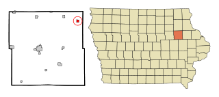
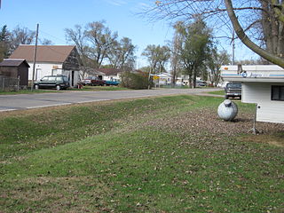
Jackson Junction is a city in Winneshiek County, Iowa, United States. The population was 37 at the time of the 2020 census.

<span class="mw-page-title-main">Jewell, Kansas</span> City in Jewell County, Kansas

Jewell is a city in Jewell County, Kansas, United States. As of the 2020 census, the population of the city was 370.

<span class="mw-page-title-main">Randall, Kansas</span> City in Jewell County, Kansas

Randall is a city in Jewell County, Kansas, United States. As of the 2020 census, the population of the city was 79.

<span class="mw-page-title-main">Easton, Maine</span> Town in the state of Maine, United States

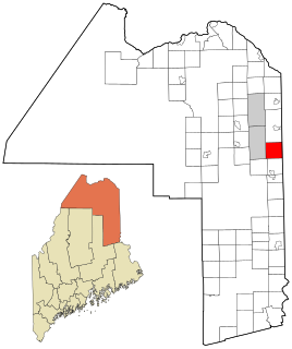
Easton is a town in Aroostook County, Maine, United States. The population was 1,320 at the 2020 census.

<span class="mw-page-title-main">Rapids, New York</span> CDP in New York, United States

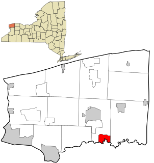
Rapids is a hamlet located in the Town of Lockport in Niagara County, New York, United States. The population was 1,636 at the 2010 census. The ZIP code for Rapids is 14094.

<span class="mw-page-title-main">Covington, Oklahoma</span> Town in Oklahoma, United States

Covington is a town in Garfield County, Oklahoma, United States. The population was 477 at the 2020 census.

<span class="mw-page-title-main">Napier Township, Bedford County, Pennsylvania</span> Township in Pennsylvania, United States

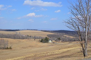
Napier Township is a township in Bedford County, Pennsylvania, United States. The population was 2,026 at the 2020 census.

<span class="mw-page-title-main">Moody, Texas</span> City in Texas, United States

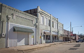
Moody is a city in McLennan County, Texas, United States. The population was 1,376 at the 2020 census. It is part of the Waco Metropolitan Statistical Area.

<span class="mw-page-title-main">Westport, Wisconsin</span> Town in Wisconsin, United States

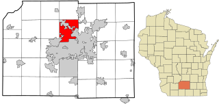
Westport is a town in Dane County, Wisconsin, United States and a suburb of Madison. The population was 4,183 at the 2020 census. The town was named after Westport, County Mayo in Ireland because many of the early settlers were from there. The village of Waunakee was carved out of the town in 1893, leaving the remainder of the town on both sides. Other portions have been annexed by the cities of Madison and Middleton.

References

  1. "2020 U.S. Gazetteer Files". United States Census Bureau. Retrieved March 16, 2022.
  2. "Jewell ZIP Code". zipdatamaps.com. 2022. Retrieved November 11, 2022.
  3. 1 2 "2020 Census State Redistricting Data". census.gov. United states Census Bureau. Retrieved 12 August 2021.
  4. 1 2 Chicago and North Western Railway Company (1908). A History of the Origin of the Place Names Connected with the Chicago & North Western and Chicago, St. Paul, Minneapolis & Omaha Railways. p. 88.
  5. "Hamilton County". Jim Forte Postal History. Retrieved 21 March 2015.
  6. "US Gazetteer files: 2010, 2000, and 1990". United States Census Bureau. 2011-02-12. Retrieved 2011-04-23.
  7. "US Gazetteer files 2010". United States Census Bureau. Archived from the original on 2012-07-02. Retrieved 2012-05-11.
  8. "Census of Population and Housing". Census.gov. Retrieved June 4, 2015.
  9. "U.S. Census website". United States Census Bureau . Retrieved 2012-05-11.
  10. "U.S. Census website". United States Census Bureau . Retrieved 2008-01-31.
  11. "South Hamilton" (PDF). Iowa Department of Education . Retrieved 2019-08-03.
  12. "Jewell Lutheran College information". Archived from the original on 2008-05-17. Retrieved 2008-07-27.