Kamrar, Iowa | |
---|---|
Coordinates: 42°23′31″N93°43′43″W / 42.39194°N 93.72861°W Coordinates: 42°23′31″N93°43′43″W / 42.39194°N 93.72861°W | |
Country | United States |
State | Iowa |
County | Hamilton |
Area | |
• Total | 0.85 sq mi (2.21 km2) |
• Land | 0.85 sq mi (2.21 km2) |
• Water | 0.00 sq mi (0.00 km2) |
Elevation | 1,122 ft (342 m) |
Population (2020) | |
• Total | 179 |
• Density | 209.60/sq mi (80.90/km2) |
Time zone | UTC-6 (Central (CST)) |
• Summer (DST) | UTC-5 (CDT) |
ZIP code | 50132 |
Area code | 515 |
FIPS code | 19-40215 |
GNIS feature ID | 0458020 |
Kamrar is a city in Hamilton County, Iowa, United States. The population was 179 at the time of the 2020 census. [2]
Kamrar was platted in 1881. [3] The city was named in honor of Judge J. M. Kamrar, a prominent lawyer of the vicinity, who served as an officer of the Chicago & Northwestern Railway Company. [3] J. M. Kamrar resided in Blue Earth, Minnesota in his final years, where he was among the first citizens to own a car. [4] There is a statue of memorial in the town square. A post office has been in operation in Kamrar since 1882. [5]
Kamrar is located at 42°23′31″N93°43′43″W / 42.39194°N 93.72861°W (42.391944, -93.728715). [6]
According to the United States Census Bureau, the city has a total area of 0.86 square miles (2.23 km2), all land. [7]
Year | Pop. | ±% |
---|---|---|
1900 | 223 | — |
1910 | 262 | +17.5% |
1920 | 256 | −2.3% |
1930 | 286 | +11.7% |
1940 | 288 | +0.7% |
1950 | 261 | −9.4% |
1960 | 268 | +2.7% |
1970 | 243 | −9.3% |
1980 | 225 | −7.4% |
1990 | 203 | −9.8% |
2000 | 229 | +12.8% |
2010 | 199 | −13.1% |
2020 | 179 | −10.1% |
Source: "U.S. Census website". United States Census Bureau . Retrieved 2020-03-29. and Iowa Data Center Source: |
At the 2010 census there were 199 people in 82 households, including 45 families, in the city. The population density was 231.4 inhabitants per square mile (89.3/km2). There were 95 housing units at an average density of 110.5 per square mile (42.7/km2). The racial makup of the city was 96.5% White, 2.0% Asian, and 1.5% from two or more races. [9]
Of the 82 households 29.3% had children under the age of 18 living with them, 45.1% were married couples living together, 6.1% had a female householder with no husband present, 3.7% had a male householder with no wife present, and 45.1% were non-families. 32.9% of households were one person and 12.2% were one person aged 65 or older. The average household size was 2.43 and the average family size was 3.31.
The median age was 40.5 years. 26.1% of residents were under the age of 18; 3.4% were between the ages of 18 and 24; 26.5% were from 25 to 44; 25% were from 45 to 64; and 18.6% were 65 or older. The gender makeup of the city was 50.8% male and 49.2% female.
At the 2000 census there were 229 people in 91 households, including 66 families, in the city. The population density was 275.9 inhabitants per square mile (106.5/km2). There were 100 housing units at an average density of 120.5 per square mile (46.5/km2). The racial makup of the city was 95.63% White, 1.31% Native American, 1.31% Asian, and 1.75% from two or more races. Hispanic or Latino of any race were 0.44%. [10]
Of the 91 households 34.1% had children under the age of 18 living with them, 56.0% were married couples living together, 12.1% had a female householder with no husband present, and 26.4% were non-families. 24.2% of households were one person and 13.2% were one person aged 65 or older. The average household size was 2.52 and the average family size was 2.93.
The age distribution was 26.2% under the age of 18, 7.4% from 18 to 24, 29.7% from 25 to 44, 18.8% from 45 to 64, and 17.9% 65 or older. The median age was 37 years. For every 100 females, there were 112.0 males. For every 100 females age 18 and over, there were 108.6 males.
The median household income was $37,188 and the median family income was $41,071. Males had a median income of $30,500 versus $21,964 for females. The per capita income for the city was $15,892. About 3.0% of families and 3.1% of the population were below the poverty line, including none of those under the age of eighteen or sixty five or over.
It is within the Webster City Community School District. [11] It was formerly in the Northeast Hamilton Community School District, [12] until it merged into the Webster City district on July 1, 2019. [13]
Hamilton County is a county located in the U.S. state of Iowa. As of the 2020 census, the population was 15,039. The county seat is Webster City. The county was named to honor William W. Hamilton, a President of the Iowa State Senate.
Fraser is a city in Dodge Township, Boone County, Iowa. The population was 101 at the time of the 2020 census. It is part of the Boone, Iowa Micropolitan Statistical Area, which is a part of the larger Ames–Boone Combined Statistical Area. The city is located along the Des Moines River.
Truesdale is a city in Buena Vista County, Iowa, United States. The population was 69 at the time of the 2020 census.
Davis City is a city in Decatur County, Iowa, United States. The population was 179 at the time of the 2020 census.
Van Wert is a city in northern Decatur County, Iowa, United States. The population was 178 at the time of the 2020 census.
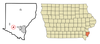
Middletown is a city in Des Moines County, Iowa, United States. The population was 363 at the time of the 2020 census. It is part of the Burlington, IA–IL Micropolitan Statistical Area.
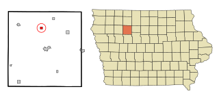
Paton is a city in Greene County, Iowa, United States. The population was 221 at the time of the 2020 census.
Blairsburg is a city in Hamilton County, Iowa, United States. The population was 176 at the 2020 census.
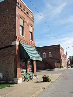
Williams is a city in Hamilton County, Iowa, United States. The population was 307 at the time of the 2020 census. Williams is a regional center of wind power generation.
Eldora is a city in Hardin County, Iowa, United States. The population was 2,663 at the time of the 2020 census. It is the county seat of Hardin County.
Wyoming is a city in Jones County, Iowa, United States. The population was 523 at the time of the 2020 census. It is part of the Cedar Rapids Metropolitan Statistical Area.
Patterson is a city in Madison County, Iowa, United States. The population was 176 at the time of the 2020 census. It is part of the Des Moines–West Des Moines Metropolitan Statistical Area.
Gilman is a city in the southeastern corner of Marshall County, Iowa, United States. The population was 542 at the time of the 2020 census. Their new website is https://gilman.ia.gov/
Ruthven is a city in Palo Alto County, Iowa, United States. The population was 725 at the time of the 2020 census.
Havelock is a city in Pocahontas County, Iowa, United States. The population was 130 at the time of the 2020 census.
Maloy is a city in southwest Ringgold County, Iowa, United States, along the Platte River. The population was 22 at the time of the 2020 census.
Spring Hill is a city in Warren County, Iowa, United States. The population was 68 at the time of the 2020 census. It is part of the Des Moines–West Des Moines Metropolitan Statistical Area.
St. Marys is a city in Warren County, Iowa, United States. The population was 108 at the time of the 2020 census.
Castalia is a city in Winneshiek County, Iowa, United States. The population was 145 at the 2020 census.
Kensett is a city in Worth County, Iowa, United States. The population was 257 at the time of the 2020 census. It is part of the Mason City Micropolitan Statistical Area.