Randall, Iowa

Last updated
Randall, Iowa
Hamilton County Iowa Incorporated and Unincorporated areas Randall Highlighted.svg
Location of Randall, Iowa
Coordinates: 42°14′15″N93°36′9″W / 42.23750°N 93.60250°W / 42.23750; -93.60250 Coordinates: 42°14′15″N93°36′9″W / 42.23750°N 93.60250°W / 42.23750; -93.60250
Country Flag of the United States.svg  United States
State Flag of Iowa.svg  Iowa
County Hamilton
Area
[1]
  Total0.41 sq mi (1.05 km2)
  Land0.41 sq mi (1.05 km2)
  Water0.00 sq mi (0.00 km2)
Elevation
1,020 ft (311 m)
Population
 (2020)
  Total154
  Density380.25/sq mi (146.64/km2)
Time zone UTC-6 (Central (CST))
  Summer (DST) UTC-5 (CDT)
ZIP code
50231
Area code 515
FIPS code 19-65595
GNIS feature ID0460520

Randall is a city in Hamilton County, Iowa, United States. The population was 154 at the time of the 2020 census. [2]

Contents

History

A post office called Randall has been in operation since 1863. [3] The city was named for Samuel J. Randall, a member of the House of Representatives from Pennsylvania. [4]

Geography

Randall is located at 42°14′15″N93°36′9″W / 42.23750°N 93.60250°W / 42.23750; -93.60250 (42.237408, -93.602532). [5]

According to the United States Census Bureau, the city has a total area of 0.41 square miles (1.06 km2), all land. [6]

Demographics

Historical populations
YearPop.±%
1950 202    
1960 201−0.5%
1970 179−10.9%
1980 171−4.5%
1990 161−5.8%
2000 148−8.1%
2010 173+16.9%
2020 154−11.0%
Source: "U.S. Census website". United States Census Bureau . Retrieved 2020-03-29. and Iowa Data Center
Source:
U.S. Decennial Census [7] [2]

2010 census

As of the census [8] of 2010, there were 173 people, 75 households, and 50 families living in the city. The population density was 422.0 inhabitants per square mile (162.9/km2). There were 79 housing units at an average density of 192.7 per square mile (74.4/km2). The racial makeup of the city was 99.4% White and 0.6% Asian.

There were 75 households, of which 28.0% had children under the age of 18 living with them, 62.7% were married couples living together, 4.0% had a female householder with no husband present, and 33.3% were non-families. 30.7% of all households were made up of individuals, and 9.4% had someone living alone who was 65 years of age or older. The average household size was 2.31 and the average family size was 2.92.

The median age in the city was 44.5 years. 22.5% of residents were under the age of 18; 4.1% were between the ages of 18 and 24; 24.3% were from 25 to 44; 32.9% were from 45 to 64; and 16.2% were 65 years of age or older. The gender makeup of the city was 52.0% male and 48.0% female.

2000 census

As of the census [9] of 2000, there were 148 people, 68 households, and 45 families living in the city. The population density was 321.8 inhabitants per square mile (124.2/km2). There were 75 housing units at an average density of 163.1 per square mile (63.0/km2). The racial makeup of the city was 100.00% White. Hispanic or Latino of any race were 1.35% of the population.

There were 68 households, out of which 27.9% had children under the age of 18 living with them, 55.9% were married couples living together, 8.8% had a female householder with no husband present, and 33.8% were non-families. 32.4% of all households were made up of individuals, and 13.2% had someone living alone who was 65 years of age or older. The average household size was 2.18 and the average family size was 2.76.

In the city, the population was spread out, with 24.3% under the age of 18, 7.4% from 18 to 24, 29.7% from 25 to 44, 25.0% from 45 to 64, and 13.5% who were 65 years of age or older. The median age was 38 years. For every 100 females, there were 100.0 males. For every 100 females age 18 and over, there were 86.7 males.

The median income for a household in the city was $30,750, and the median income for a family was $40,875. Males had a median income of $27,500 versus $22,500 for females. The per capita income for the city was $20,991. There were 4.4% of families and 6.4% of the population living below the poverty line, including no under eighteens and 16.7% of those over 64.

Education

South Hamilton Community School District serves this community. [10]

Related Research Articles

<span class="mw-page-title-main">Hamilton County, Iowa</span> County in Iowa, United States

Hamilton County is a county located in the U.S. state of Iowa. As of the 2020 census, the population was 15,039. The county seat is Webster City. The county was named to honor William W. Hamilton, a President of the Iowa State Senate.

<span class="mw-page-title-main">Kempton, Illinois</span> Village in Illinois, United States

Kempton is a village in Ford County, Illinois, United States. The population was 231 at the 2010 census.

<span class="mw-page-title-main">Blairsburg, Iowa</span> City in Iowa, United States

Blairsburg is a city in Hamilton County, Iowa, United States. The population was 176 at the 2020 census.

<span class="mw-page-title-main">Jewell Junction, Iowa</span> City in Iowa, United States

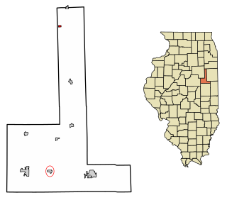
Jewell Junction, better known as Jewell, is a city in Hamilton County, Iowa, United States. The population was 1,216 at the time of the 2020 census.

<span class="mw-page-title-main">Randall, Kansas</span> City in Jewell County, Kansas

Randall is a city in Jewell County, Kansas, United States. As of the 2020 census, the population of the city was 79.

<span class="mw-page-title-main">Randall, Minnesota</span> City in Minnesota, United States

Randall is a city in Morrison County, Minnesota, United States. The population was 607 at the 2020 census.

<span class="mw-page-title-main">Geraldine, Montana</span> Town in Montana, United States

Geraldine is a town in Chouteau County, Montana, United States. The population was 207 at the 2020 census. The area around the town is an agricultural, largely wheat-producing, region.

<span class="mw-page-title-main">Primrose, Nebraska</span> Village in Nebraska, United States

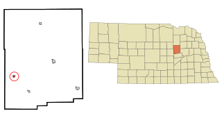
Primrose is a village in Boone County, Nebraska, United States. The population was 61 at the 2010 census.

<span class="mw-page-title-main">Leigh, Nebraska</span> Village in Nebraska, United States

Leigh is a village in Colfax County, Nebraska, United States. The population was 405 at the 2010 census.

<span class="mw-page-title-main">Ord, Nebraska</span> City in Nebraska, United States

Ord is a city in Valley County, Nebraska, United States. The population was 2,112 at the 2010 census. It is the county seat of Valley County.

Plymouth is a town in Chenango County, New York, United States. The population was 1,804 at the 2010 census. It is an interior town in the northern part of the county. The town is northwest of the city of Norwich.

<span class="mw-page-title-main">North Randall, Ohio</span> Village in Ohio, United States

North Randall is a village in Cuyahoga County, Ohio, United States. The population was 1,027 at the 2010 census.

<span class="mw-page-title-main">Newcomerstown, Ohio</span> Village in Ohio, United States

Newcomerstown is a village in Tuscarawas County, Ohio, United States, 85 miles (137 km) east-northeast of Columbus. In the late 1770s, this was the largest Delaware Indian village on the Tuscarawas River, with 700 residents. Chief Newcomer (Netawatwes) was the leader of the western Delawares here, and they called the village Gekelmukpechunk. Early French traders and English settlers named the village Newcomerstown after the chief. Soon after the start of the American Revolutionary War, the Delawares moved west to Coshocton, about halfway through what is now the next county.

<span class="mw-page-title-main">Berrysburg, Pennsylvania</span> Borough in Pennsylvania, United States

Berrysburg is a borough in Dauphin County, Pennsylvania, United States. The population was 324 at the 2020 census. It is part of the Harrisburg–Carlisle Metropolitan Statistical Area.

<span class="mw-page-title-main">Vanleer, Tennessee</span> Town in Tennessee, United States

Vanleer is a town in Dickson County, Tennessee, United States. The population was estimated to be 422 in 2019, up from 395 at the 2010 census. The town is approximately 49 miles northwest of Nashville and is located within the city's greater metropolitan area.

<span class="mw-page-title-main">East Ridge, Tennessee</span> City in Tennessee, United States

East Ridge is a city in Hamilton County, Tennessee, United States. As of the 2020 census, the city population was 22,167. East Ridge is bordered by Chattanooga to the west, north, and east, and the Georgia state line to the south. It is part of the Chattanooga, TN–GA Metropolitan Statistical Area. The name of the city comes from its location due east of Missionary Ridge. The Bachman Tubes beneath Missionary Ridge link East Ridge with downtown Chattanooga.

<span class="mw-page-title-main">Parkwood, Washington</span> CDP in Washington, United States

Parkwood is a census-designated place (CDP) in Kitsap County, Washington, United States. The population was 7,126 at the 2010 census.

<span class="mw-page-title-main">Stratford, Iowa</span> City in Iowa, United States

Stratford is a city in Hamilton and Webster counties in the U.S. state of Iowa. The population was 707 at the time of the 2020 census.

<span class="mw-page-title-main">Shell Knob, Missouri</span> Census-designated place in Missouri, United States

Shell Knob is a census-designated place (CDP) located within White River Township, Barry County, Missouri. The population was 1,254 at the 2020 census.

<span class="mw-page-title-main">Utica, Ohio</span> Village in Ohio, United States

Utica is a village in Knox and Licking counties in the U.S. state of Ohio, along the North Fork of the Licking River. The population was 2,132 at the 2010 census.

References

  1. "2020 U.S. Gazetteer Files". United States Census Bureau. Retrieved March 16, 2022.
  2. 1 2 "2020 Census State Redistricting Data". census.gov. United states Census Bureau. Retrieved 12 August 2021.
  3. "Hamilton County". Jim Forte Postal History. Retrieved 26 March 2015.
  4. Chicago and North Western Railway Company (1908). A History of the Origin of the Place Names Connected with the Chicago & North Western and Chicago, St. Paul, Minneapolis & Omaha Railways. p. 116.
  5. "US Gazetteer files: 2010, 2000, and 1990". United States Census Bureau. 2011-02-12. Retrieved 2011-04-23.
  6. "US Gazetteer files 2010". United States Census Bureau. Archived from the original on 2012-07-02. Retrieved 2012-05-11.
  7. "Census of Population and Housing". Census.gov. Retrieved June 4, 2015.
  8. "U.S. Census website". United States Census Bureau . Retrieved 2012-05-11.
  9. "U.S. Census website". United States Census Bureau . Retrieved 2008-01-31.
  10. "South Hamilton" (PDF). Iowa Department of Education . Retrieved 2019-08-03.