Muscatine County, Iowa

Last updated

Muscatine County
Muscatine Court House.JPG
Muscatine County Courthouse in Muscatine
Map of Iowa highlighting Muscatine County.svg
Location within the U.S. state of Iowa
Iowa in United States.svg
Iowa's location within the U.S.
Coordinates: 41°28′52″N91°07′11″W / 41.481111111111°N 91.119722222222°W / 41.481111111111; -91.119722222222
CountryFlag of the United States.svg United States
StateFlag of Iowa.svg  Iowa
FoundedDecember 7, 1836
Named for Mascouten tribe
Seat Muscatine
Largest cityMuscatine
Area
  Total449 sq mi (1,160 km2)
  Land437 sq mi (1,130 km2)
  Water12 sq mi (30 km2)  2.6%
Population
 (2020)
  Total43,235
  Density96/sq mi (37/km2)
Time zone UTC−6 (Central)
  Summer (DST) UTC−5 (CDT)
Congressional district 1st
Website www.muscatinecountyiowa.gov

Muscatine County is a county located in the U.S. state of Iowa. As of the 2020 census, the population was 43,235. [1] The county seat is Muscatine. [2] The southeastern border is formed by the Mississippi River.

Contents

Muscatine County comprises the Muscatine, IA Micropolitan Statistical Area, which is included in the Davenport-Moline, IA-IL Combined Statistical Area.

History

Muscatine County was formed in December 1836 as a part of Wisconsin Territory, partitioned from Des Moines County, which had been organized two years previously. [3] One history suggests that the county was named for Muscatine Island in the Mississippi River. The island lies opposite Muscatine County and was believed to be named after the Mascouten tribe, Algonquian-speaking Native Americans who lived in the area before being driven west by settler encroachment and other tribes. [4]

Colonel George Davenport of Illinois sent three representatives into the territory in 1833 to establish a trade post. They were the first European Americans to settle there. In the same year, James W. Casey and John Vanatta came to the area. They opened a supply depot for steamboats on June 1, 1833, and named it Casey's Woodpile (since steamboats used wood as fuel). Muscatine County became part of Iowa Territory on July 4, 1838, when it was established by partitioning the area from Wisconsin Territory. [3] The first public land sale was held in November 1838. One year later, officials began construction of the first courthouse and associated jail. A second jail, known as the "Old Jail", was built in 1857. [5]

The first courthouse was destroyed by fire on December 23, 1864. By 1866 a replacement stood on the same site. The present courthouse opened on September 26, 1907. [6]

Geography

According to the US Census Bureau, the county has a total area of 449 square miles (1,160 km2), of which 437 square miles (1,130 km2) is land and 12 square miles (31 km2) (2.6%) is water. [7]

Adjacent counties

Transportation

Transit

Major highways

Other roadway designations

County highways

  • County Highway F58 (formerly Hwy 927)
  • County Highway F62
  • County Highway F65
  • County Highway F70 (155th St)
  • County Highway G14 (180th St)
  • County Highway G28 (230th/231st Sts)
  • County Highway G34 (275th St)
  • County Highway G38 (Fruitland Rd)
  • County Highway X34 (Davis Ave)
  • County Highway X40 (Garfield Ave)
  • County Highway X46 (Kelly Ave/170th St)
  • County Highway X61 (Stewart Rd)
  • County Highway Y14 (Taylor Ave)
  • County Highway Y26 (Vail Ave)
  • County Highway Y30 (Western Ave)
  • County Highway Y36 (Zachary Ave)

Demographics

Historical population
CensusPop.Note
1850 5,731
1860 16,444186.9%
1870 21,68831.9%
1880 23,1706.8%
1890 24,5045.8%
1900 28,24215.3%
1910 29,5054.5%
1920 29,042−1.6%
1930 29,3851.2%
1940 31,2966.5%
1950 32,1482.7%
1960 33,8405.3%
1970 37,1819.9%
1980 40,4368.8%
1990 39,907−1.3%
2000 41,7224.5%
2010 42,7452.5%
2020 43,2351.1%
2023 (est.)42,218 [9] −2.4%
U.S. Decennial Census [10]
1790-1960 [11] 1900-1990 [12]
1990-2000 [13] 2010-2018 [14]
Population of Muscatine County from US census data MuscatineCountyIowaPop2020.png
Population of Muscatine County from US census data

2020 census

2022 US Census population pyramid for Muscatine County from ACS 5-year estimates MuscatineCountyIA2022PopPyr.png
2022 US Census population pyramid for Muscatine County from ACS 5-year estimates

The 2020 census recorded a population of 43,235 in the county, with a population density of

Muscatine County Racial Composition [15]
RaceNum.Perc.
White (NH)27,43875.5%
Black or African American (NH)1,0862.5%
Native American (NH)580.13%
Asian (NH)4040.93%
Pacific Islander (NH)00%
Other/Mixed (NH)1,2853%
Hispanic or Latino 7,76918%

2010 census

The 2010 census recorded a population of 42,745 in the county, with a population density of

2000 census

As of the census [17] of 2000, there were 41,722 people, 15,847 households, and 11,283 families residing in the county. The population density was 95 inhabitants per square mile (37/km2). There were 16,786 housing units at an average density of 38 per square mile (15/km2). The racial makeup of the county was 90.72% White, 0.70% Black or African American, 0.31% Native American, 0.83% Asian, 0.02% Pacific Islander, 6.05% from other races, and 1.37% from two or more races. 11.92% of the population were Hispanic or Latino of any race.

There were 15,847 households, out of which 34.80% had children under the age of 18 living with them, 57.90% were married couples living together, 9.30% had a female householder with no husband present, and 28.80% were non-families. 24.10% of all households were made up of individuals, and 9.90% had someone living alone who was 65 years of age or older. The average household size was 2.59 and the average family size was 3.07.

In the county, the population was spread out, with 26.90% under the age of 18, 8.60% from 18 to 24, 28.80% from 25 to 44, 22.80% from 45 to 64, and 12.90% who were 65 years of age or older. The median age was 36 years. For every 100 females, there were 98.10 males. For every 100 females age 18 and over, there were 94.90 males.

The median income for a household in the county was $41,803, and the median income for a family was $48,373. Males had a median income of $36,329 versus $24,793 for females. The per capita income for the county was $19,625. About 6.30% of families and 8.90% of the population were below the poverty line, including 10.70% of those under age 18 and 7.70% of those age 65 or over.

C.S. Barclay farm illustration in 1875 Barclay barn 1875.jpg
C.S. Barclay farm illustration in 1875

Communities

Cities

Census-designated places

Other unincorporated communities

Townships

Population ranking

The population ranking of the table is based on the 2020 census of Muscatine County. [1]

county seat

RankCity/Town/etc.Municipal typePopulation (2020 Census)
1 Muscatine City23,797
2 West Liberty City3,858
3 Wilton (partially in Cedar County )City2,924
4 Durant (mostly in Scott and Cedar Counties)City1,871
5 Blue Grass (mostly in Scott County)City1,666
6 Walcott (partially in Scott County)City1,551
7 Fruitland City963
8 Conesville City352
9 Nichols City340
10 Atalissa City296
11 Stockton City176

Politics

United States presidential election results for Muscatine County, Iowa [18]
Year Republican Democratic Third party
No.%No.%No.%
2020 10,82352.36%9,37245.34%4762.30%
2016 9,58449.32%8,36843.06%1,4827.63%
2012 8,16841.12%11,32357.00%3741.88%
2008 7,92941.47%10,92057.11%2711.42%
2004 9,02048.19%9,54250.98%1550.83%
2000 7,48346.55%8,05850.12%5353.33%
1996 5,85838.07%7,67449.88%1,85412.05%
1992 6,08736.09%7,08942.04%3,68821.87%
1988 6,90448.96%7,05950.06%1390.99%
1984 9,06959.79%5,98639.46%1130.74%
1980 7,82951.69%5,59736.96%1,71911.35%
1976 7,69753.10%6,56745.30%2321.60%
1972 8,43661.84%4,91736.04%2892.12%
1968 7,36157.18%4,72636.71%7876.11%
1964 5,54740.86%8,02059.07%100.07%
1960 8,55558.21%6,13541.74%80.05%
1956 8,55259.81%5,71839.99%280.20%
1952 9,36161.60%5,77237.98%630.41%
1948 6,00351.68%5,46647.06%1461.26%
1944 7,10459.38%4,80140.13%580.48%
1940 8,54359.24%5,82540.39%530.37%
1936 6,33247.56%6,59349.52%3882.91%
1932 6,16047.69%6,42349.73%3342.59%
1928 8,60467.45%4,05531.79%980.77%
1924 7,73164.87%1,96316.47%2,22318.65%
1920 8,11570.30%2,29319.86%1,1369.84%
1916 3,92954.25%2,69437.20%6198.55%
1912 78911.10%2,67937.68%3,64251.22%
1908 3,52549.43%3,03842.60%5687.97%
1904 4,03657.04%2,55536.11%4856.85%
1900 3,90554.92%3,02142.49%1842.59%
1896 3,62755.02%2,86343.43%1021.55%

See also

Related Research Articles

<span class="mw-page-title-main">Black Hawk County, Iowa</span> County in Iowa, United States

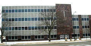
Black Hawk County is a county in the northeastern part of U.S. state of Iowa. As of the 2020 census, the population was 131,144, making it Iowa's fifth-most populous county. The county seat is Waterloo.

<span class="mw-page-title-main">Washington County, Iowa</span> County in Iowa, United States

Washington County is a county located in the U.S. state of Iowa. As of the 2020 census, the population was 22,565. The county seat is Washington.

<span class="mw-page-title-main">Scott County, Iowa</span> County in Iowa, United States

Scott County is a county located in the U.S. state of Iowa. As of the 2020 census, the population was 174,669, making it the third-most populous county in Iowa. The county seat is Davenport.

<span class="mw-page-title-main">Sac County, Iowa</span> County in Iowa, United States

Sac County is a county located in the U.S. state of Iowa. As of the 2020 census, the population was 9,814. The county seat is Sac City. Both were named for the Sauk people, a local American Indian tribe.

<span class="mw-page-title-main">Mahaska County, Iowa</span> County in Iowa, United States

Mahaska County is a county located in the U.S. state of Iowa. As of the 2020 census, the population was 22,190. The county seat is Oskaloosa.

<span class="mw-page-title-main">Louisa County, Iowa</span> County in Iowa, United States

Louisa County is a county located in the U.S. state of Iowa. As of the 2020 census, the population was 10,837. The county seat is Wapello.

<span class="mw-page-title-main">Linn County, Iowa</span> County in Iowa, United States

Linn County is a county located in the U.S. state of Iowa. As of the 2020 census, the population was 230,299, making it the second-most populous county in Iowa. The county seat is Cedar Rapids. Linn County is named in honor of Senator Lewis F. Linn of Missouri. Linn County is included in the Cedar Rapids, IA Metropolitan Statistical Area.

<span class="mw-page-title-main">Johnson County, Iowa</span> County in Iowa, United States

Johnson County is located in the U.S. state of Iowa. As of the 2020 census, the population was 152,854, making it the fourth-most populous county in Iowa. The county seat is Iowa City, home of the University of Iowa. Johnson County is included in the Iowa City metropolitan area, which is also included in the Cedar Rapids-Iowa City Corridor Combined Statistical Area.

<span class="mw-page-title-main">Dallas County, Iowa</span> County in Iowa, United States

Dallas County is a county located in the U.S. state of Iowa. As of the 2020 Census, the population was 99,678, making it the seventh-most populous county in Iowa. Between 2010 and 2020, it was the fastest growing county in Iowa and one of the fastest growing in the country. Its county seat is Adel, and its largest city is Waukee. The county was named for George M. Dallas, Vice President of the United States under James K. Polk, the namesake of neighboring Polk County.

<span class="mw-page-title-main">Crawford County, Iowa</span> County in Iowa, United States

Crawford County is a county located in the U.S. state of Iowa. As of the 2020 census, the population was 16,525. Its county seat is Denison. The county was named for William Harris Crawford, U.S. senator from Georgia and United States Secretary of the Treasury.

<span class="mw-page-title-main">Cedar County, Iowa</span> County in Iowa, United States

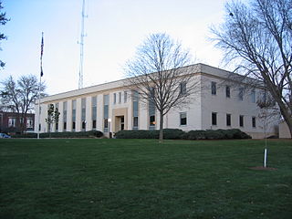
Cedar County is a county located in the U.S. state of Iowa. As of the 2020 census, the population was 18,505. Its county seat is Tipton. The county is named for the Cedar River, which runs through the county.

<span class="mw-page-title-main">Boone County, Iowa</span> County in Iowa, United States

Boone County is a county in the U.S. state of Iowa. As of the 2020 census, the population was 26,715. Its county seat is Boone.

<span class="mw-page-title-main">Keithsburg, Illinois</span> City in Illinois, United States

Keithsburg is a city in Mercer County, Illinois, United States, on the Mississippi River. The population was 550 at the 2020 census, down from 609 in 2010. It was named for Robert Keith, a pioneer settler.

<span class="mw-page-title-main">New Boston, Illinois</span> City in Illinois, United States

New Boston is a city in Mercer County, Illinois, United States on the Mississippi River. The population was 613 at the 2020 census, down from 683 in 2010.

<span class="mw-page-title-main">Durant, Iowa</span> City in Iowa, United States

Durant is a city in Cedar, Muscatine, and Scott counties in the U.S. state of Iowa. The population was 1,871 at the time of the 2020 census.

<span class="mw-page-title-main">Tipton, Iowa</span> City in Iowa, United States

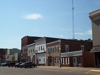
Tipton (/ˈtɪptən/) is a city in Cedar County, Iowa, United States. The population was 3,149 at the time of the 2020 census. It is the county seat of Cedar County.

<span class="mw-page-title-main">Wilton, Iowa</span> City in Iowa, United States

Wilton is a city in Cedar and Muscatine counties in the U.S. state of Iowa. The population was 2,924 at the time of the 2020 census. The Muscatine County portion of Wilton is part of the Muscatine Micropolitan Statistical Area.

<span class="mw-page-title-main">Fruitland, Iowa</span> City in Iowa, United States

Fruitland is a city in Muscatine County, Iowa, United States. The population was 963 at the time of the 2020 census. It is part of the Muscatine Micropolitan Statistical Area.

<span class="mw-page-title-main">Muscatine, Iowa</span> City in Iowa

Muscatine is a city in Muscatine County, Iowa, United States. The population was 23,797 at the time of the 2020 census, an increase from 22,697 in 2000. The county seat of Muscatine County, it is located along the Mississippi River. The local business association states that the name Muscatine is not used by any other community.

Cedar Valley Township is a township in Saint Louis County, Minnesota, United States. Cedar Valley Township was named for the white cedar in the valley of the Floodwood River. The population was 195 at the 2010 census.

References

  1. 1 2 3 "2020 Census State Redistricting Data". census.gov. United states Census Bureau. Retrieved August 12, 2021.
  2. "Find a County". National Association of Counties. Retrieved June 7, 2011.
  3. 1 2 "WI: Individual County Chronologies". publications.newberry.org. Archived from the original on April 14, 2017. Retrieved September 28, 2016.
  4. History of Muscatine County Iowa - History Section, 1879 , retrieved May 11, 2009
  5. "Local Sights". Muscatine County Sheriff. Archived from the original on February 8, 2012. Retrieved April 23, 2012.
  6. History Archived July 28, 2012, at the Wayback Machine
  7. "US Gazetteer files: 2010, 2000, and 1990". US Census Bureau. February 12, 2011. Retrieved April 23, 2011.
  8. Muscatine County Google Maps (accessed 17 August 2018)
  9. "Annual Estimates of the Resident Population for Counties: April 1, 2020 to July 1, 2023". United States Census Bureau. Retrieved April 2, 2024.
  10. "U.S. Decennial Census". United States Census Bureau. Retrieved July 20, 2014.
  11. "Historical Census Browser". University of Virginia Library. Retrieved July 20, 2014.
  12. "Population of Counties by Decennial Census: 1900 to 1990". US Census Bureau. Retrieved July 20, 2014.
  13. "Census 2000 PHC-T-4. Ranking Tables for Counties: 1990 and 2000" (PDF). US Census Bureau. Archived (PDF) from the original on March 27, 2010. Retrieved July 20, 2014.
  14. "State & County QuickFacts". United States Census Bureau. Archived from the original on June 7, 2011. Retrieved July 20, 2014.
  15. "P2 HISPANIC OR LATINO, AND NOT HISPANIC OR LATINO BY RACE – 2020: DEC Redistricting Data (PL 94-171) – Muscatine County, Iowa".
  16. "Population & Housing Occupancy Status 2010" (PDF). US Census Bureau – American FactFinder. Archived (PDF) from the original on October 16, 2020. Retrieved August 15, 2022.
  17. "U.S. Census website". US Census Bureau. Retrieved January 31, 2008.
  18. Leip, David. "Dave Leip's Atlas of U.S. Presidential Elections". uselectionatlas.org. Retrieved April 27, 2018.

41°28′52″N91°07′11″W / 41.48111°N 91.11972°W / 41.48111; -91.11972