Nichols, Iowa

Last updated
Nichols, Iowa
Nichols, Iowa.JPG
Muscatine County Iowa Incorporated and Unincorporated areas Nichols Highlighted.svg
Location of Nichols, Iowa
Coordinates: 41°28′45″N91°18′30″W / 41.47917°N 91.30833°W / 41.47917; -91.30833 Coordinates: 41°28′45″N91°18′30″W / 41.47917°N 91.30833°W / 41.47917; -91.30833
Country Flag of the United States.svg  United States
State Flag of Iowa.svg  Iowa
County Muscatine
Area
[1]
  Total0.23 sq mi (0.59 km2)
  Land0.23 sq mi (0.59 km2)
  Water0.00 sq mi (0.00 km2)
Elevation
633 ft (193 m)
Population
 (2020)
  Total340
  Density1,491.23/sq mi (576.25/km2)
Time zone UTC-6 (Central (CST))
  Summer (DST) UTC-5 (CDT)
ZIP code
52766
Area code 319
FIPS code 19-56685
GNIS feature ID0459517
Main Street, Nichols, Iowa Nichols, Main Street.jpg
Main Street, Nichols, Iowa

Nichols is a city in Muscatine County, Iowa, United States. The population was 340 at the time of the 2020 census. [2] It is part of the Muscatine Micropolitan Statistical Area.

Contents

Name

The original name of the site of the current town was Railroad Addition. The town was later referred to as Nichols Station in reference to the previous holder of the town's site. Nichols was named by the early settler Benjamin F. Nichols in honor of his father, Samuel Nichols, who was instrumental in bringing the railroad to the area. Samuel Nichols was a heavy investor in the Burlington, Cedar Rapids and Northern Railroad Company as well as owner of large landholdings. Samuel Nichols had given the rail company the right of way to construct the rail line across his land, as well as to establish a depot at the current site of Nichols. [3]

History

Nichols was established in the early 1870s in an area of Section 15 of Pike Township known locally as Elephant Swamp. The community was intended as a rail town for the shipment of agriculture products and furs to distant markets, and had been constructed on land donated to the rail company by Samuel and Benjamin Nichols with the intention of establishing a rail depot. The lots for the future community were surveyed by county surveyor George Bumgardner in June 1871. Two rail lines would eventually run through the town – the Muscatine & Western Railroad and the Burlington, Cedar Rapids and Northern Railroad – which were both branches of the Rock Island system. The first rail line and rail depot was constructed in the early 1870s. Dr. S. H. Smith constructed the first building on the future site of Nichols in 1871, which Mr Smith used as both a drug store and as a home. Construction on the Muscatine & Western Railroad reached the site in 1873, and the rail company laid out an addition to the town, calling it Railroad Addition. At first many of the buildings and homes in the community were log cabins, which were then replaced by more permanent brick buildings. Benjamin Nichols established the first post office in 1870 and served as the first postmaster. The first school was built in 1872. In the winter of 1873-1874 a Christian church was organized with services being held in schoolhouses until the construction of the church in 1874, with services being conducted by Rev. John Powell. The German Evangelical Protestant Church was organized in 1874 by Rev. K. F. Obermann. The Catholic church – Church of St. Mary - was built in 1874 with Father Nicholas Dugan serving as its first pastor. A Methodist church was organized in 1875 by J. A. Bolton. The town soon grew with the addition of several banks, an opera house, and a town hall that was constructed in 1897. The early economy of the community centered on the two rail lines that ran through the community as well as the buying and shipping of furs as well as agriculture. The Foley and Brugman Brothers operated two large grain elevators which held 15,000 bushels each. Cattle and hogs were also shipped out to markets through the rail lines. [4] [5]

On September 18, 2020, Nichols' central business district was listed on the National Register of Historic Places as the Ijem Avenue Commercial Historic District. [6]

Geography

Nichols is located at 41°28′45″N91°18′30″W / 41.47917°N 91.30833°W / 41.47917; -91.30833 (41.479113, -91.308291) [7] in section 15 of Pike Township, situated in the western edge of Iowa's Muscatine County. The area is a mix of prairie and rich bottom land. Jordan Creek flows just southeast of the community and flows into Wapsinonoc Creek, a tributary of the Cedar River.

According to the United States Census Bureau, the city has a total area of 0.23 square miles (0.60 km2), all land. [8]

Demographics

Historical populations
YearPop.±%
1880 286    
1890 237−17.1%
1900 398+67.9%
1910 396−0.5%
1920 387−2.3%
1930 369−4.7%
1940 357−3.3%
1950 348−2.5%
1960 329−5.5%
1970 396+20.4%
1980 375−5.3%
1990 366−2.4%
2000 374+2.2%
2010 374+0.0%
2020 340−9.1%
Source: "U.S. Census website". United States Census Bureau . Retrieved 2020-03-29. and Iowa Data Center
Source:
U.S. Decennial Census [9] [2]

2010 census

As of the census [10] of 2010, there were 374 people, 142 households, and 105 families residing in the city. The population density was 1,626.1 inhabitants per square mile (627.8/km2). There were 150 housing units at an average density of 652.2 per square mile (251.8/km2). The racial makeup of the city was 87.4% White, 1.1% African American, 2.1% Asian, 8.3% from other races, and 1.1% from two or more races. Hispanic or Latino of any race were 16.3% of the population.

There were 142 households, of which 35.9% had children under the age of 18 living with them, 54.2% were married couples living together, 14.1% had a female householder with no husband present, 5.6% had a male householder with no wife present, and 26.1% were non-families. 22.5% of all households were made up of individuals, and 5.6% had someone living alone who was 65 years of age or older. The average household size was 2.63 and the average family size was 2.99.

The median age in the city was 36.3 years. 28.6% of residents were under the age of 18; 6.4% were between the ages of 18 and 24; 26.5% were from 25 to 44; 27.4% were from 45 to 64; and 11.2% were 65 years of age or older. The gender makeup of the city was 50.5% male and 49.5% female.

2000 census

As of the census [11] of 2000, there were 374 people, 138 households, and 102 families residing in the city. The population density was 1,604.8 inhabitants per square mile (619.6/km2). There were 142 housing units at an average density of 609.3 per square mile (235.3/km2). The racial makeup of the city was 86.36% White, 1.07% African American, 1.60% Asian, 9.89% from other races, and 1.07% from two or more races. Hispanic or Latino of any race were 22.99% of the population.

There were 138 households, out of which 34.1% had children under the age of 18 living with them, 61.6% were married couples living together, 11.6% had a female householder with no husband present, and 25.4% were non-families. 19.6% of all households were made up of individuals, and 8.7% had someone living alone who was 65 years of age or older. The average household size was 2.71 and the average family size was 3.03.

In the city, the population was spread out, with 26.2% under the age of 18, 11.5% from 18 to 24, 28.1% from 25 to 44, 24.6% from 45 to 64, and 9.6% who were 65 years of age or older. The median age was 34 years. For every 100 females, there were 105.5 males. For every 100 females age 18 and over, there were 97.1 males.

The median income for a household in the city was $43,750, and the median income for a family was $47,917. Males had a median income of $32,045 versus $21,750 for females. The per capita income for the city was $16,082. About 4.7% of families and 13.7% of the population were below the poverty line, including 11.8% of those under age 18 and 14.0% of those age 65 or over.

Education

The West Liberty Community School District operates local public schools. [12]

Related Research Articles

<span class="mw-page-title-main">Muscatine County, Iowa</span> County in Iowa, United States

Muscatine County is a county located in the U.S. state of Iowa. As of the 2020 census, the population was 43,235. The county seat is Muscatine. The southeastern border is formed by the Mississippi River.

<span class="mw-page-title-main">Sheldahl, Iowa</span> City in Iowa, United States

Sheldahl is a city in Polk, Boone, and Story counties in the U.S. state of Iowa. The population was 297 at the time of the 2020 census.

<span class="mw-page-title-main">Jolley, Iowa</span> City in Iowa, United States

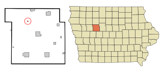
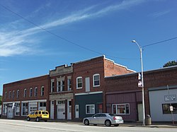
Jolley is a city in Calhoun County, Iowa, United States. The population was 28 at the time of the 2020 census.

<span class="mw-page-title-main">Durant, Iowa</span> City in Iowa, USA

Durant is a city in Cedar, Muscatine, and Scott counties in the U.S. state of Iowa. The population was 1,871 at the time of the 2020 census.

<span class="mw-page-title-main">Wilton, Iowa</span> City in Iowa, United States

Wilton is a city in Cedar and Muscatine counties in the U.S. state of Iowa. The population was 2,924 at the time of the 2020 census. The Muscatine County portion of Wilton is part of the Muscatine Micropolitan Statistical Area.

<span class="mw-page-title-main">Columbus Junction, Iowa</span> City in Iowa, United States

Columbus Junction is a city in Louisa County, Iowa. The population was 1,830 at the 2020 census. It is part of the Muscatine Micropolitan Statistical Area.

<span class="mw-page-title-main">Grandview, Iowa</span> City in Iowa, United States

Grandview is a city in Louisa County, Iowa, United States. The population was 437 at the time of the 2020 census. It is part of the Muscatine Micropolitan Statistical Area.

<span class="mw-page-title-main">Letts, Iowa</span> City in Iowa, United States

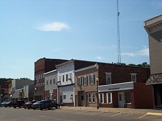
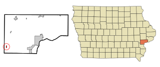
Letts is a city in northern Louisa County, Iowa, United States, established in 1855. The population was 363 at the time of the 2020 census. It is part of the Muscatine Micropolitan Statistical Area. The name is taken from that of local benefactor, Nehemiah Madison Letts.

<span class="mw-page-title-main">Knoxville, Iowa</span> City in Iowa, United States

Knoxville is a city in Marion County, Iowa, United States. The population was 7,595 at the time of the 2020 census, an increase from 7,313 in the 2010 census. It is the county seat of Marion County. Knoxville is home of the National Sprint Car Hall of Fame & Museum, located next to the famous Knoxville Raceway dirt track.

<span class="mw-page-title-main">Atalissa, Iowa</span> City in Iowa, United States

Atalissa is a city in Muscatine County, Iowa, United States. The population was 296 at the 2020 census. It is part of the Muscatine Micropolitan Statistical Area.

<span class="mw-page-title-main">Conesville, Iowa</span> City in Iowa, United States

Conesville is a city in Muscatine County, Iowa, United States. The population was 352 at the 2020 census. It is part of the Muscatine Micropolitan Statistical Area.

<span class="mw-page-title-main">Fruitland, Iowa</span> City in Iowa, United States

Fruitland is a city in Muscatine County, Iowa, United States. The population was 963 at the time of the 2020 census. It is part of the Muscatine Micropolitan Statistical Area.

<span class="mw-page-title-main">Muscatine, Iowa</span> City in Iowa

Muscatine is a city in Muscatine County, Iowa, United States. The population was 23,797 at the time of the 2020 census, an increase from 22,697 in 2000. The county seat of Muscatine County, it is located along the Mississippi River. The local business association states that the name Muscatine is not used by any other community.

<span class="mw-page-title-main">Stockton, Iowa</span> City in Iowa, United States

Stockton is a city in Muscatine County, Iowa, United States. The population was 176 at the time of the 2020 census. It is part of the Muscatine Micropolitan Statistical Area.

<span class="mw-page-title-main">West Liberty, Iowa</span> City in Iowa, United States

West Liberty is a city in Muscatine County, Iowa, United States. The population was 3,858 at the time of the 2020 census. It is part of the Muscatine micropolitan area.

<span class="mw-page-title-main">Ayrshire, Iowa</span> City in Iowa, United States

Ayrshire is a city in Palo Alto County, Iowa, United States. The population was 133 at the 2020 census.

<span class="mw-page-title-main">Blue Grass, Iowa</span> City in Iowa, USA

Blue Grass is a city in Muscatine and Scott counties in the U.S. state of Iowa. The population was 1,666 as of 2020.

<span class="mw-page-title-main">Corydon, Iowa</span> City in Iowa, United States

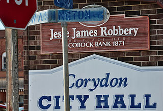
Corydon is a city in Wayne County, Iowa, United States. The population was 1,526 in the 2020 census, a decline from 1,591 in 2000. It is the county seat of Wayne County.

<span class="mw-page-title-main">Walcott, Iowa</span> City in Iowa, United States

Walcott is a city in Muscatine and Scott counties in the U.S. state of Iowa. The population was 1,551 at the time of the 2020 census. Walcott's interchange on Interstate 80 is home to an enormous complex of restaurants, motels and truck stops, including the Iowa 80 truck stop, which is the world's largest.

<span class="mw-page-title-main">Nevada, Iowa</span> City in Iowa, United States

Nevada is a city in, and the county seat of, Story County, Iowa, United States. The population was 6,925 in the 2020 census, an increase from 6,658 in 2000. Nevada is part of the Ames, Iowa Metropolitan Statistical Area, which is a part of the larger Ames-Boone, Iowa Combined Statistical Area. Nevada is the second-most populous city in Story County, Iowa. The city's name is pronounced differently from the U.S. state of Nevada.

References

  1. "2020 U.S. Gazetteer Files". United States Census Bureau. Retrieved March 16, 2022.
  2. 1 2 "2020 Census State Redistricting Data". census.gov. United states Census Bureau. Retrieved 12 August 2021.
  3. Richman, Irving Berdine (1911). History of Muscatine County, Iowa: From the Earliest Settlements to the Present Time. S. J. Clarke Publishing Company. pp.  238.
  4. rving Berdine Richman (1911). "History of Muscatine County, Iowa: From the Earliest Settlements to the Present Time, Volume 1".{{cite journal}}: Cite journal requires |journal= (help)
  5. Western Historical Company (1879). "The History of Muscatine County, Iowa". Western historical Company: 582. nichols iowa history.{{cite journal}}: Cite journal requires |journal= (help)
  6. "National Register of Historic Places Program: Weekly List". National Park Service. September 25, 2020. Retrieved 2020-10-05.
  7. "US Gazetteer files: 2010, 2000, and 1990". United States Census Bureau. 2011-02-12. Retrieved 2011-04-23.
  8. "US Gazetteer files 2010". United States Census Bureau. Archived from the original on 2012-01-25. Retrieved 2012-05-11.
  9. "Census of Population and Housing". Census.gov. Retrieved June 4, 2015.
  10. "U.S. Census website". United States Census Bureau . Retrieved 2012-05-11.
  11. "U.S. Census website". United States Census Bureau . Retrieved 2008-01-31.
  12. "West Liberty" (PDF). Iowa Department of Education . Retrieved 2020-07-28.