Blue Grass, Iowa

Last updated

Blue Grass, Iowa
City
Blue Grass, Iowa Community Center.jpg
Blue Grass Community Center
Motto: 
A Great Place To Call Home Since 1853
Scott County Iowa Incorporated and Unincorporated areas Blue Grass Highlighted.svg
Location of Blue Grass, Iowa
Coordinates: 41°30′43″N90°45′54″W / 41.51194°N 90.76500°W / 41.51194; -90.76500
CountryUnited States
State Flag of Iowa.svg  Iowa
Counties Muscatine, Scott
Government
  MayorBrad Schutte
Area
[1]
  City3.16 sq mi (8.18 km2)
  Land3.16 sq mi (8.18 km2)
  Water0.00 sq mi (0.00 km2)
Elevation
791 ft (241 m)
Population
 (2020)
  City1,666
  Density527.22/sq mi (203.56/km2)
   Metro
382,630 (135th)
Time zone UTC-6 (Central (CST))
  Summer (DST) UTC-5 (CDT)
ZIP code
52726
Area code 563
FIPS code 19-07075
GNIS feature ID0454709
Website www.bluegrassia.org

Blue Grass is a city in Muscatine and Scott counties in the U.S. state of Iowa. The population was 1,666 as of 2020. [2] [3]

Contents

Most of Blue Grass is part of the DavenportMolineRock Island, IA-IL Metropolitan Statistical Area, but the Muscatine County portion of the city is considered part of the Muscatine Micropolitan Statistical Area.

Geography

According to the United States Census Bureau, the city has a total area of 2.89 square miles (7.49 km2), all land. [4]

Demographics

Historical populations
YearPop.±%
1880 70    
1910 223+218.6%
1920 205−8.1%
1930 246+20.0%
1940 287+16.7%
1950 337+17.4%
1960 568+68.5%
1970 1,032+81.7%
1980 1,377+33.4%
1990 1,214−11.8%
2000 1,169−3.7%
2010 1,452+24.2%
2020 1,666+14.7%
Source: "U.S. Census website". United States Census Bureau . Retrieved March 29, 2020. and Iowa Data Center
Source:
U.S. Decennial Census [5] [2]
The population of Blue Grass, Iowa from US census data Blue GrassIowaPopPlot.png
The population of Blue Grass, Iowa from US census data

2010 census

As of the census [6] of 2010, there were 1,452 people, 561 households, and 426 families living in the city. The population density was 502.4 inhabitants per square mile (194.0/km2). There were 597 housing units at an average density of 206.6 per square mile (79.8/km2). The racial makeup of the city was 97.0% White, 1.2% African American, 0.4% Native American, 0.2% Asian, 0.1% from other races, and 1.0% from two or more races. Hispanic or Latino of any race were 1.8% of the population.

There were 561 households, of which 34.8% had children under the age of 18 living with them, 62.9% were married couples living together, 6.4% had a female householder with no husband present, 6.6% had a male householder with no wife present, and 24.1% were non-families. 20.0% of all households were made up of individuals, and 7.7% had someone living alone who was 65 years of age or older. The average household size was 2.59 and the average family size was 2.93.

The median age in the city was 39.4 years. 24.7% of residents were under the age of 18; 6.7% were between the ages of 18 and 24; 26.3% were from 25 to 44; 28% were from 45 to 64; and 14% were 65 years of age or older. The gender makeup of the city was 51.9% male and 48.1% female.

2000 census

As of the census [7] of 2000, there were 1,169 people, 443 households, and 348 families living in the city. The population density was 434.0 inhabitants per square mile (167.6/km2). There were 459 housing units at an average density of 170.4 per square mile (65.8/km2). The racial makeup of the city was 97.43% White, 0.26% African American, 0.26% Native American, 0.26% Asian, 0.94% from other races, and 0.86% from two or more races. Hispanic or Latino of any race were 1.80% of the population.

There were 443 households, out of which 35.0% had children under the age of 18 living with them, 62.5% were married couples living together, 12.2% had a female householder with no husband present, and 21.4% were non-families. 16.9% of all households were made up of individuals, and 6.1% had someone living alone who was 65 years of age or older. The average household size was 2.64 and the average family size was 2.95.

Age spread: 25.1% under the age of 18, 8.0% from 18 to 24, 29.9% from 25 to 44, 27.4% from 45 to 64, and 9.7% who were 65 years of age or older. The median age was 37 years. For every 100 females, there were 95.5 males. For every 100 females age 18 and over, there were 95.5 males.

The median income for a household in the city was $51,923, and the median income for a family was $55,208. Males had a median income of $37,135 versus $22,350 for females. The per capita income for the city was $20,811. About 3.8% of families and 4.9% of the population were below the poverty line, including 5.7% of those under age 18 and 4.3% of those age 65 or over.

Education

Residents of the city are zoned to the Davenport Community School District. [8] Zoned schools include Blue Grass Elementary School, [9] Walcott Intermediate School, [10] and Davenport West High School. [11]

Muscatine Community School District operates public schools serving nearby rural areas. [12] Muscatine High School is the district's high school.

See also

Related Research Articles

<span class="mw-page-title-main">Scott County, Iowa</span> County in Iowa, United States

Scott County is a county located in the U.S. state of Iowa. As of the 2020 census, the population was 174,669, making it the third-most populous county in Iowa. The county seat is Davenport.

<span class="mw-page-title-main">Muscatine County, Iowa</span> County in Iowa, United States

Muscatine County is a county located in the U.S. state of Iowa. As of the 2020 census, the population was 43,235. The county seat is Muscatine. The southeastern border is formed by the Mississippi River.

<span class="mw-page-title-main">Marne, Iowa</span> City in Iowa, United States

Marne is a city in Cass County, Iowa, United States. The population was 110 at the time of the 2020 census.

<span class="mw-page-title-main">Durant, Iowa</span> City in Iowa, United States

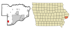
Durant is a city in Cedar, Muscatine, and Scott counties in the U.S. state of Iowa. The population was 1,871 at the time of the 2020 census.

<span class="mw-page-title-main">Wilton, Iowa</span> City in Iowa, United States

Wilton is a city in Cedar and Muscatine counties in the U.S. state of Iowa. The population was 2,924 at the time of the 2020 census. The Muscatine County portion of Wilton is part of the Muscatine Micropolitan Statistical Area.

<span class="mw-page-title-main">Sigourney, Iowa</span> City in Iowa, United States

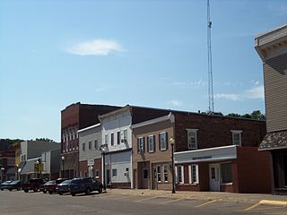
Sigourney is a city in Keokuk County, Iowa, United States. The population was 2,004 at the time of the 2020 census. It is the county seat of Keokuk County. Keokuk County Courthouse is located in the Public Square Historic District. Both are on the National Register of Historic Places.

<span class="mw-page-title-main">Columbus Junction, Iowa</span> City in Iowa, United States

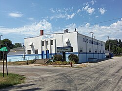
Columbus Junction is a city in Louisa County, Iowa. The population was 1,830 at the 2020 census. It is part of the Muscatine Micropolitan Statistical Area.

<span class="mw-page-title-main">Grandview, Iowa</span> City in Iowa, United States

Grandview is a city in Louisa County, Iowa, United States. The population was 437 at the time of the 2020 census. It is part of the Muscatine Micropolitan Statistical Area.

<span class="mw-page-title-main">Letts, Iowa</span> City in Iowa, United States

Letts is a city in northern Louisa County, Iowa, United States, established in 1855. The population was 363 at the time of the 2020 census. It is part of the Muscatine Micropolitan Statistical Area. The name is taken from that of local benefactor, Nehemiah Madison Letts.

<span class="mw-page-title-main">Wapello, Iowa</span> City in Iowa, United States

Wapello is a city in and the county seat of Louisa County, Iowa, United States. The population was 2,084 at the time of the 2020 census.

<span class="mw-page-title-main">Atalissa, Iowa</span> City in Iowa, United States

Atalissa is a city in Muscatine County, Iowa, United States. The population was 296 at the 2020 census. It is part of the Muscatine Micropolitan Statistical Area.

<span class="mw-page-title-main">Conesville, Iowa</span> City in Iowa, United States

Conesville is a city in Muscatine County, Iowa, United States. The population was 352 at the 2020 census. It is part of the Muscatine Micropolitan Statistical Area.

<span class="mw-page-title-main">Fruitland, Iowa</span> City in Iowa, United States

Fruitland is a city in Muscatine County, Iowa, United States. The population was 963 at the time of the 2020 census. It is part of the Muscatine Micropolitan Statistical Area.

<span class="mw-page-title-main">Nichols, Iowa</span> City in Iowa, United States

Nichols is a city in Muscatine County, Iowa, United States. The population was 340 at the time of the 2020 census. It is part of the Muscatine Micropolitan Statistical Area.

<span class="mw-page-title-main">Stockton, Iowa</span> City in Iowa, United States

Stockton is a city in Muscatine County, Iowa, United States. The population was 176 at the time of the 2020 census. It is part of the Muscatine Micropolitan Statistical Area.

<span class="mw-page-title-main">Buffalo, Iowa</span> City in Iowa, United States

Buffalo is a city in Scott County, Iowa, United States. The population was 1,176 at the 2020 census. Buffalo is located on the Mississippi River. The city is a part of the Quad Cities Metropolitan Area.

<span class="mw-page-title-main">Riverdale, Iowa</span> City in Iowa, United States

Riverdale is a city in Scott County, Iowa, United States. The population was 379 at the time of the 2020 census.

<span class="mw-page-title-main">Panama, Iowa</span> City in Iowa, United States

Panama is a city in Shelby County, Iowa, United States. The population was 235 at the time of the 2020 census.

<span class="mw-page-title-main">Tennant, Iowa</span> City in Iowa, United States

Tennant is a city in Shelby County, Iowa, United States. The population was 78 at the time of the 2020 census.

<span class="mw-page-title-main">Walcott, Iowa</span> City in Iowa, United States

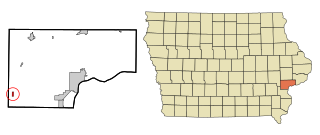
Walcott is a city in Muscatine and Scott counties in the U.S. state of Iowa. The population was 1,551 at the time of the 2020 census. Walcott's interchange on Interstate 80 is home to an enormous complex of restaurants, motels and truck stops, including the Iowa 80 truck stop, which is the world's largest.

References

  1. "2020 U.S. Gazetteer Files". United States Census Bureau. Retrieved March 16, 2022.
  2. 1 2 "2020 Census State Redistricting Data". census.gov. United states Census Bureau. Retrieved August 12, 2021.
  3. "Blue Grass, IA Population Growth and Population Statistics - CLRSearch". Archived from the original on July 29, 2012.
  4. "US Gazetteer files 2010". United States Census Bureau. Archived from the original on January 12, 2012. Retrieved 2012-05-11.
  5. "Census of Population and Housing". Census.gov. Retrieved June 4, 2015.
  6. "U.S. Census website". United States Census Bureau . Retrieved May 11, 2012.
  7. "U.S. Census website". United States Census Bureau . Retrieved 2008-01-31.
  8. "Davenport" (PDF). Iowa Department of Education. Archived from the original (PDF) on March 29, 2020. Retrieved March 28, 2020.
  9. "DCSD Intermediate Schools (Map)" (PDF). Davenport Community School District . Retrieved March 28, 2020. - Blue Grass Elementary School detail map and Detail map #2
  10. "DCSD Intermediate Schools (Map)" (PDF). Davenport Community School District . Retrieved March 28, 2020. - Walcott Intermediate School detail map
  11. "DCSD High Schools (Map)" (PDF). Davenport Community School District. Archived from the original (PDF) on June 9, 2017. Retrieved March 28, 2020. - West High School detail map Archived June 9, 2017, at the Wayback Machine
  12. "District". Muscatine Community School District. Retrieved March 28, 2020. It also includes the towns of Fairport and Montpelier, as well as portions of the rural areas of Letts and Blue Grass. - Blue Grass does not appear in the district's map