Long Grove, Iowa

Last updated

Long Grove, Iowa
City
Long Grove, Iowa 01.jpg
Scott County Iowa Incorporated and Unincorporated areas Long Grove Highlighted.svg
Location of Long Grove, Iowa
Coordinates: 41°41′49″N90°35′6″W / 41.69694°N 90.58500°W / 41.69694; -90.58500 Coordinates: 41°41′49″N90°35′6″W / 41.69694°N 90.58500°W / 41.69694; -90.58500
CountryUnited States
State Flag of Iowa.svg  Iowa
County Scott
Government
  MayorMichael Limberg
  Mayor Pro TemCindy Blinkinsop
Area
[1]
  City1.15 sq mi (2.98 km2)
  Land1.15 sq mi (2.98 km2)
  Water0.00 sq mi (0.00 km2)
Elevation
794 ft (242 m)
Population
 (2020)
  City838
  Density728.06/sq mi (281.03/km2)
   Metro
382,630 (135th)
Time zone UTC-6 (Central (CST))
  Summer (DST) UTC-5 (CDT)
ZIP code
52756
Area code 563
FIPS code 19-46425
GNIS feature ID0458594
Website www.longgroveia.org

Long Grove is a city in Scott County, Iowa, United States. The population was 838 at the time of the 2020 census. [2]

Contents

Geography

Long Grove is located at 41°41′49″N90°35′6″W / 41.69694°N 90.58500°W / 41.69694; -90.58500 (41.696806, −90.584974). [3]

According to the United States Census Bureau, the city has a total area of 1.02 square miles (2.64 km2), all land. [4]

Education

Long Grove is part of the North Scott Community School District, which spans 220 square miles (570 km2) in northern Scott County. [5] Elementary-aged students from the city and adjoining nearby areas attend Alan Shepard Elementary. Junior high and high school students attend the North Scott Junior High and North Scott High School located in Eldridge.

Culture

The town's annual celebration represents Long Grove's claim to fame: The Strawberry Festival. Held the second Sunday each June, the day kicks off at 9 am with the Strawberry Stampede – youth fun/competitive fitness footraces followed by a parade at 11:15 am. Area strawberry farmers sell strawberries, there are games for children, a children's Strawberry Pageant, Trivia Contest, Raffle, Strawberry Cooking Contest, petting zoo, pony rides, wagon rides, and a variety of entertainment groups throughout the day. Community organizations provide a wide variety of food choices. Strawberry shortcake, ice cream, kettle corn and other foods are available throughout the day.

Another attraction is the Alexander Brownlie Sod House, on the city's north side. The sod house was built by the Brownlie Brothers dates from Iowa's prairie days of the 1830s. The house, which is open for tours, is listed on the National Register of Historic Places.

Located approximately six miles north and east of Long Grove is the Dan Nagle Walnut Grove Pioneer Village, at the north edge of Scott County Park. The village, a re-creation of an 1860s Scott County cross-roads settlement and stage coach, is made up of 18 historic buildings including an old church, a bank, a train depot and boardwalk of shops. Numerous events are scheduled throughout the year.

Scott County Park is a 1,280-acre (5 km2) county park that offers numerous amenities and camping facilities.

Organizations include the Lion Grove Lions Club, the Long Grove Civic League, the Long Grove Sportsman's Club and the Cub Scouts.

Government

Long Grove has a mayor-council form of government, and meets on the second Tuesday of each month at city hall. The city also has fire and police protection.

Also representing city interests are:

History

Long Grove derives its name from the long, narrow strip of timber, which stretched from Walnut Grove (northeast of where Scott County Park now lies) to Allens Grove, several miles to the northwest.

Alexander and James Brownlie came to the area in August 1838, having followed the Mississippi River to the mouth of the Wapsipinicon River, then west along its banks. The two purchased a nearby timber ridge from a man named coats, settling the claim for $160 plus timberland and all the prairie they wished to own. The first log cabin was built shortly thereafter, in a cluster of trees at the east edge of the timber, just south of the original townsite.

A stage road, from Davenport to DeWitt and Dubuque passed through the village and a blacksmith shop and harness shop once lined the streets.

In the late 1860s, the railroad was extended from Davenport to Long Grove and stopped at what was originally known as Noel Station, in honor of John T. Noel, pioneer, township trustee and civil servant. [6] The town, which had not been platted, was finally platted in the 1890s, though on a very loose basis.

A major incident in the city's history took place in December 1921, with the robbery of the Stockman's Savings Bank. Stories varied on what transpired, but what is known is that the two suspects were killed by a posse immediately after they attempted to hold up the bank.

The city remained a quiet farming community for many years, but has seen growth in the past 35 years. Along with the opening of Alan Shepard Elementary School, many new homes have been built on all four sides of the city.

Churches

Long Grove Christian Church Long Grove, Iowa 02.jpg
Long Grove Christian Church
St. Ann's Catholic Church and Cemetery St. Ann's Church, Long Grove, Iowa.JPG
St. Ann's Catholic Church and Cemetery

Churches located in or near Long Grove are:

Demographics

Historical populations
YearPop.±%
1920 158    
1930 134−15.2%
1940 139+3.7%
1950 156+12.2%
1960 182+16.7%
1970 269+47.8%
1980 596+121.6%
1990 605+1.5%
2000 597−1.3%
2010 808+35.3%
2020 838+3.7%
Source: "American FactFinder". United States Census Bureau. Archived from the original on February 12, 2020. Retrieved March 29, 2020. and Iowa Data Center
Source:
U.S. Decennial Census [7] [2]

2010 census

As of the census [8] of 2010, there were 808 people, 281 households, and 244 families living in the city. The population density was 792.2 inhabitants per square mile (305.9/km2). There were 287 housing units at an average density of 281.4 per square mile (108.6/km2). The racial makeup of the city was 97.8% White, 0.2% Asian, 0.2% Pacific Islander, 0.2% from other races, and 1.5% from two or more races. Hispanic or Latino of any race were 3.3% of the population.

There were 281 households, of which 41.6% had children under the age of 18 living with them, 76.2% were married couples living together, 6.4% had a female householder with no husband present, 4.3% had a male householder with no wife present, and 13.2% were non-families. 11.4% of all households were made up of individuals, and 3.9% had someone living alone who was 65 years of age or older. The average household size was 2.88 and the average family size was 3.10.

The median age in the city was 41.1 years. 28.6% of residents were under the age of 18; 7.1% were between the ages of 18 and 24; 22.3% were from 25 to 44; 32.2% were from 45 to 64; and 9.7% were 65 years of age or older. The gender makeup of the city was 51.0% male and 49.0% female.

2000 census

As of the census [9] of 2000, there were 597 people, 205 households, and 175 families living in the city. The population density was 707.2 inhabitants per square mile (273.1/km2). There were 208 housing units at an average density of 246.4 per square mile (95.1/km2). The racial makeup of the city was 99.66% White, and 0.34% from two or more races. Hispanic or Latino of any race were 0.17% of the population.

There were 205 households, out of which 46.8% had children under the age of 18 living with them, 78.5% were married couples living together, 6.8% had a female householder with no husband present, and 14.6% were non-families. 12.2% of all households were made up of individuals, and 4.4% had someone living alone who was 65 years of age or older. The average household size was 2.91 and the average family size was 3.18.

31.2% were under the age of 18, 5.2% from 18 to 24, 28.6% from 25 to 44, 28.1% from 45 to 64, and 6.9% were 65 years of age or older. The median age was 38 years. For every 100 females, there were 102.4 males. For every 100 females age 18 and over, there were 104.5 males.

The median income for a household in the city was $65,250, and the median income for a family was $68,125. Males had a median income of $44,821 versus $30,156 for females. The per capita income for the city was $23,041. About 1.3% of families and 2.1% of the population were below the poverty line, including 0.5% of those under age 18 and 8.0% of those age 65 or over.

Notable people

Related Research Articles

<span class="mw-page-title-main">Montgomery County, Iowa</span> County in Iowa, United States

Montgomery County is a county located in the southwestern area of the U.S. state of Iowa. As of the 2020 census, the population was 10,330. Its population has declined since a peak in 1900, since urbanization and decline of family farms. The county seat is Red Oak. The county was founded by European-American migrants from eastern areas in 1851. It was named in honor of Richard Montgomery, an American Revolutionary War general killed in 1775 while trying to capture Quebec City, Canada.

<span class="mw-page-title-main">Scott County, Iowa</span> County in Iowa, United States

Scott County is a county located in the U.S. state of Iowa. As of the 2020 census, the population was 174,669, making it the third-most populous county in Iowa. The county seat is Davenport.

<span class="mw-page-title-main">Clarence, Iowa</span> City in Iowa, United States

Clarence is a city in Cedar County, Iowa, United States. The population was 1,039 at the time of the 2020 census.

<span class="mw-page-title-main">Durant, Iowa</span> City in Iowa, United States

Durant is a city in Cedar, Muscatine, and Scott counties in the U.S. state of Iowa. The population was 1,871 at the time of the 2020 census.

<span class="mw-page-title-main">Strawberry Point, Iowa</span> City in Iowa, United States

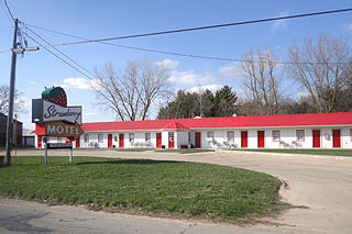
Strawberry Point is a city in Clayton County, Iowa, United States. The population was 1,155 at the time of the 2020 United States Census, down from 1,386 in 2000 census. Strawberry Point is home to the world's largest strawberry, and the Franklin Hotel, which was listed on the National Register of Historic Places in 1999. Backbone State Park, Iowa's oldest state park, is located a few miles from the town.

<span class="mw-page-title-main">Buck Grove, Iowa</span> City in Iowa, United States

Buck Grove is a city in Crawford County, Iowa, United States. The population was 34 at the 2020 census.

<span class="mw-page-title-main">Ida Grove, Iowa</span> City in Iowa, United States

Ida Grove is a city in Ida County, Iowa, United States. The population was 2,051 at the time of the 2020 census. It is the county seat of Ida County.

<span class="mw-page-title-main">Lambs Grove, Iowa</span> City in Iowa, United States

Lambs Grove is a city in Jasper County, Iowa, United States. The population was 174 as of the 2020 Census, down from 225 recorded in 2000.

<span class="mw-page-title-main">Lynnville, Iowa</span> City in Iowa, United States

Lynnville is a city in Jasper County, Iowa, United States. The population was 380 at the time of the 2020 census.

<span class="mw-page-title-main">Shueyville, Iowa</span> City in Iowa, United States

Shueyville is a city in Johnson County, Iowa, United States. It is part of the Iowa City, Iowa Metropolitan Statistical Area. The population was 731 at the time of the 2020 census.

<span class="mw-page-title-main">Buffalo, Iowa</span> City in Iowa, United States

Buffalo is a city in Scott County, Iowa, United States. The population was 1,176 at the 2020 census. Buffalo is located on the Mississippi River. The city is a part of the Quad Cities Metropolitan Area.

<span class="mw-page-title-main">Dixon, Iowa</span> City in Iowa, United States

Dixon is a city in Scott County, Iowa, United States. The population was 202 at the time of the 2020 census.

<span class="mw-page-title-main">Donahue, Iowa</span> City in Iowa, United States

Donahue is a city in Scott County, Iowa, United States. The population was 335 at the 2020 census. The city has a mayor-council form of government.

<span class="mw-page-title-main">Eldridge, Iowa</span> City in Iowa, United States

Eldridge is a city in Scott County, Iowa, United States. The population was 6,726 in the 2020 Census; Eldridge is a suburb and part of the Quad Cities metropolitan area.

<span class="mw-page-title-main">Maysville, Iowa</span> City in Iowa, United States

Maysville is a city in Scott County, Iowa, United States. The population was 156 at the time of the 2020 census.

<span class="mw-page-title-main">McCausland, Iowa</span> City in Iowa, United States

McCausland is a city in Butler Township, Scott County, Iowa, United States. The population was 313 at the time of the 2020 census.

<span class="mw-page-title-main">New Liberty, Iowa</span> City in Iowa, USA

New Liberty is a city in Scott County, Iowa, United States. The population was 138 at the time of the 2020 census.

<span class="mw-page-title-main">Riverdale, Iowa</span> City in Iowa, United States

Riverdale is a city in Scott County, Iowa, United States. The population was 379 at the time of the 2020 census.

<span class="mw-page-title-main">Farmington, Iowa</span> City in Iowa, United States

Farmington is a city in Van Buren County, Iowa, United States. The population was 579 at the time of the 2020 census.

<span class="mw-page-title-main">Eagle Grove, Iowa</span> City in Iowa, United States

Eagle Grove is a city in Wright County, Iowa, United States. The population was 3,601 at the time of the 2020 census. Eagle Grove is the largest city in Wright County.

References

  1. "2020 U.S. Gazetteer Files". United States Census Bureau. Retrieved March 16, 2022.
  2. 1 2 "2020 Census State Redistricting Data". census.gov. United states Census Bureau. Retrieved August 12, 2021.
  3. "US Gazetteer files: 2010, 2000, and 1990". United States Census Bureau. February 12, 2011. Retrieved April 23, 2011.
  4. "US Gazetteer files 2010". United States Census Bureau. Archived from the original on January 12, 2012. Retrieved May 11, 2012.
  5. "North Scott" (PDF). Iowa Department of Education. Retrieved July 20, 2020.
  6. The History of Scott County Iowa Vol. 2 1910 Harry Downer pp. 284-286
  7. "Census of Population and Housing". Census.gov. Retrieved June 4, 2015.
  8. "American FactFinder". United States Census Bureau. Archived from the original on February 12, 2020. Retrieved May 11, 2012.
  9. "American FactFinder". United States Census Bureau. Archived from the original on February 12, 2020. Retrieved January 31, 2008.