McCausland, Iowa

Last updated

McCausland, Iowa
City
McCausland, Iowa.jpg
Scott County Iowa Incorporated and Unincorporated areas McCausland Highlighted.svg
Location of McCausland, Iowa
Coordinates: 41°44′41″N90°26′33″W / 41.74472°N 90.44250°W / 41.74472; -90.44250
CountryUnited States
State Flag of Iowa.svg  Iowa
County Scott
Area
[1]
  City0.58 sq mi (1.50 km2)
  Land0.55 sq mi (1.44 km2)
  Water0.02 sq mi (0.06 km2)
Elevation
610 ft (186 m)
Population
 (2020)
  City313
  Density564.98/sq mi (217.96/km2)
   Metro
381,342 (134th)
Time zone UTC-6 (Central (CST))
  Summer (DST) UTC-5 (CDT)
ZIP code
52758
Area code 563
FIPS code 19-47820
GNIS feature ID0458887

McCausland is a city in Butler Township, Scott County, Iowa, United States. The population was 313 at the time of the 2020 census. [2]

Contents

The city was founded in 1882 by D.C. McCausland, a landowner and horse trader. [3]

Geography

McCausland is located at 41°44′41″N90°26′33″W / 41.74472°N 90.44250°W / 41.74472; -90.44250 (41.744804, −90.442613). [4]

According to the United States Census Bureau, the city has a total area of 0.56 square miles (1.45 km2), of which 0.54 square miles (1.40 km2) is land and 0.02 square miles (0.05 km2) is water. [5]

Demographics

Historical populations
YearPop.±%
1910 106    
1920 110+3.8%
1930 104−5.5%
1940 115+10.6%
1950 150+30.4%
1960 173+15.3%
1970 226+30.6%
1980 381+68.6%
1990 308−19.2%
2000 299−2.9%
2010 291−2.7%
2020 313+7.6%
Source: "American FactFinder". United States Census Bureau. Archived from the original on February 12, 2020. Retrieved March 29, 2020. and Iowa Data Center
Source:
U.S. Decennial Census [6] [2]

2010 census

As of the census [7] of 2010, there were 291 people, 115 households, and 86 families living in the city. The population density was 538.9 inhabitants per square mile (208.1/km2). There were 123 housing units at an average density of 227.8 per square mile (88.0/km2). The racial makeup of the city was 97.9% White, 0.7% from other races, and 1.4% from two or more races. Hispanic or Latino of any race were 1.7% of the population.

There were 115 households, of which 36.5% had children under the age of 18 living with them, 66.1% were married couples living together, 5.2% had a female householder with no husband present, 3.5% had a male householder with no wife present, and 25.2% were non-families. 20.0% of all households were made up of individuals, and 7% had someone living alone who was 65 years of age or older. The average household size was 2.53 and the average family size was 2.90.

The median age in the city was 40.1 years. 22.3% of residents were under the age of 18; 6.3% were between the ages of 18 and 24; 29.9% were from 25 to 44; 28.8% were from 45 to 64; and 12.7% were 65 years of age or older. The gender makeup of the city was 49.8% male and 50.2% female.

2000 census

As of the census [8] of 2000, there were 299 people, 117 households, and 84 families living in the city. The population density was 559.5 inhabitants per square mile (216.0/km2). There were 120 housing units at an average density of 224.6 per square mile (86.7/km2). The racial makeup of the city was 99.00% White, 0.33% Native American, and 0.67% from two or more races. Hispanic or Latino of any race were 0.33% of the population.

There were 117 households, out of which 36.8% had children under the age of 18 living with them, 62.4% were married couples living together, 6.8% had a female householder with no husband present, and 27.4% were non-families. 23.9% of all households were made up of individuals, and 11.1% had someone living alone who was 65 years of age or older. The average household size was 2.56 and the average family size was 3.06.

25.4% are under the age of 18, 9.0% from 18 to 24, 31.1% from 25 to 44, 24.4% from 45 to 64, and 10.0% who were 65 years of age or older. The median age was 34 years. For every 100 females, there were 104.8 males. For every 100 females age 18 and over, there were 99.1 males.

The median income for a household in the city was $34,531, and the median income for a family was $40,313. Males had a median income of $26,667 versus $24,688 for females. The per capita income for the city was $22,426. About 1.4% of families and 6.3% of the population were below the poverty line, including 11.7% of those under the age of eighteen and 3.0% of those 65 or over.

Education

McCausland is part of the North Scott Community School District, which spans 220 square miles (570 km2) in northern Scott County. [9]

Related Research Articles

<span class="mw-page-title-main">Chuichu, Arizona</span> CDP in Pinal County, Arizona

Chuichu is a census-designated place (CDP) in Pinal County, Arizona, United States. The population was 308 at the 2020 census. It is the northernmost traditional village on the Tohono O'odham Nation reservation.

<span class="mw-page-title-main">Carlisle, Arkansas</span> City in Arkansas, United States

Carlisle is a city in Lonoke County, Arkansas, United States. It is the easternmost municipality within the Little Rock–North Little Rock–Conway Metropolitan Statistical Area. Carlisle was incorporated in 1878. As of the 2010 census it had a population of 2,214.

<span class="mw-page-title-main">Little Rock, Iowa</span> City in Iowa, United States

Little Rock is an incorporated city in Lyon County, Iowa, United States, along the Little Rock River. The population was 439 at the time of the 2020 census. The zip code for Little Rock is 51243.

<span class="mw-page-title-main">St. Anthony, Iowa</span> City in Iowa, United States

St. Anthony is a city in Marshall County, Iowa, United States. The population was 76 at the time of the 2020 census.

<span class="mw-page-title-main">Hancock, Iowa</span> City in Iowa, United States

Hancock is a city in Pottawattamie County, Iowa, United States, along the West Nishnabotna River. The population was 200 at the time of the 2020 census.

<span class="mw-page-title-main">Dixon, Iowa</span> City in Iowa, United States

Dixon is a city in Scott County, Iowa, United States. The population was 202 at the time of the 2020 census.

<span class="mw-page-title-main">Alma, Kansas</span> City in Wabaunsee County, Kansas

Alma is a city in and the county seat of Wabaunsee County, Kansas, United States. As of the 2020 census, the population of the city was 802.

<span class="mw-page-title-main">Island, Kentucky</span> City in Kentucky, United States

Island is a home rule-class city in McLean County, Kentucky, in the United States. The population was 429 at the 2020 census. It is included in the Owensboro metropolitan area.

<span class="mw-page-title-main">Albion, Maine</span> Town in the state of Maine, United States

Albion is a town in Kennebec County, Maine, United States. The population was 2,006 at the 2020 census.

<span class="mw-page-title-main">Grasston, Minnesota</span> City in Minnesota, United States

Grasston is a city in Kanabec County, Minnesota, United States. The population was 158 at the 2010 census.

<span class="mw-page-title-main">Morton, Minnesota</span> City in Minnesota, United States

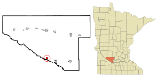
Morton is a city in Renville County, Minnesota, United States. This city is ninety-five miles southwest of Minneapolis. It is the administrative headquarters of the Lower Sioux Indian Reservation. The population was 411 at the 2010 census.

<span class="mw-page-title-main">Pine Springs, Minnesota</span> City in Minnesota, United States

Pine Springs is a city in Washington County, Minnesota, United States. The population was 408 at the 2010 census.

<span class="mw-page-title-main">Lamar Heights, Missouri</span> City in Missouri, United States

Lamar Heights is a city in Barton County, Missouri, United States. The population was 170 at the 2020 census.

<span class="mw-page-title-main">Worthington, West Virginia</span> Town in West Virginia, United States

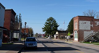
Worthington is a town in Marion County, West Virginia, United States. The population was 158 at the 2010 census. Worthington was incorporated in 1893 and named for Colonel George Worthington, an early settler. U.S. Route 19 passes through the town.

<span class="mw-page-title-main">Greenwood, Wisconsin</span> City in Wisconsin, United States

Greenwood is a city in Clark County in the U.S. state of Wisconsin. The population was 1,026 at the 2010 census.

<span class="mw-page-title-main">Rewey, Wisconsin</span> Village in Wisconsin, United States

Rewey is a village in Iowa County, Wisconsin, United States. The population was 292 at the 2010 census. It is part of the Madison Metropolitan Statistical Area.

<span class="mw-page-title-main">Gilmore City, Iowa</span> City in Iowa, United States

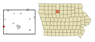
Gilmore City is a city in Humboldt and Pocahontas counties in the U.S. state of Iowa. The population was 487 at the time of the 2020 census.

<span class="mw-page-title-main">Wadena, Minnesota</span> City in Minnesota, United States

Wadena is a city in Otter Tail and Wadena counties in the state of Minnesota. It is about one hundred sixty miles northwest of the Minneapolis – Saint Paul metro area. The population was 4,325 at the 2020 census. It is the county seat of Wadena County.

<span class="mw-page-title-main">Dorchester, Wisconsin</span> Village in Wisconsin, United States

Dorchester is a village in Clark and Marathon counties in the U.S. state of Wisconsin, along the 45th parallel. It is part of the Wausau, Wisconsin Metropolitan Statistical Area. The population was 876 at the 2010 census. Of this, 871 were in Clark County, and only 5 were in Marathon County.

<span class="mw-page-title-main">Pepin, Wisconsin</span> Village in Wisconsin, United States

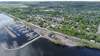
Pepin is a village in Pepin County, Wisconsin, United States. The population was 837 at the 2010 census. The village is located within the Town of Pepin.

References

  1. "2020 U.S. Gazetteer Files". United States Census Bureau. Retrieved March 16, 2022.
  2. 1 2 "2020 Census State Redistricting Data". census.gov. United states Census Bureau. Retrieved August 12, 2021.
  3. "Who We Are".
  4. "US Gazetteer files: 2010, 2000, and 1990". United States Census Bureau. February 12, 2011. Retrieved April 23, 2011.
  5. "US Gazetteer files 2010". United States Census Bureau. Archived from the original on January 12, 2012. Retrieved May 11, 2012.
  6. "Census of Population and Housing". Census.gov. Archived from the original on April 26, 2015. Retrieved June 4, 2015.
  7. "American FactFinder". United States Census Bureau. Archived from the original on February 12, 2020. Retrieved May 11, 2012.
  8. "American FactFinder". United States Census Bureau. Archived from the original on February 12, 2020. Retrieved January 31, 2008.
  9. "North Scott" (PDF). Iowa Department of Education. Retrieved July 20, 2020.