Maysville, Iowa

Last updated

Maysville, Iowa
City
Maysville, Iowa.jpg
Motto: 
Viva La Maysville
Scott County Iowa Incorporated and Unincorporated areas Maysville Highlighted.svg
Location of Maysville, Iowa
Coordinates: 41°38′57″N90°43′6″W / 41.64917°N 90.71833°W / 41.64917; -90.71833 Coordinates: 41°38′57″N90°43′6″W / 41.64917°N 90.71833°W / 41.64917; -90.71833
CountryUnited States
State Flag of Iowa.svg  Iowa
County Scott
Area
[1]
  City0.27 sq mi (0.71 km2)
  Land0.27 sq mi (0.71 km2)
  Water0.00 sq mi (0.00 km2)
Elevation
738 ft (225 m)
Population
 (2020)
  City156
  Density569.34/sq mi (220.21/km2)
   Metro
381,342 (134th)
Time zone UTC-6 (Central (CST))
  Summer (DST) UTC-5 (CDT)
ZIP code
52773
Area code 563
FIPS code 19-50655
GNIS feature ID0458874

Maysville is a city in Scott County, Iowa, United States. The population was 156 at the time of the 2020 census. [2]

Contents

Geography

Maysville is located at 41°38′57″N90°43′6″W / 41.64917°N 90.71833°W / 41.64917; -90.71833 (41.649179, −90.718341). [3]

According to the United States Census Bureau, the city has a total area of 0.27 square miles (0.70 km2), all land. [4]

Demographics

Historical populations
YearPop.±%
1910 55    
1920 85+54.5%
1930 57−32.9%
1940 44−22.8%
1950 70+59.1%
1960 126+80.0%
1970 170+34.9%
1980 151−11.2%
1990 170+12.6%
2000 163−4.1%
2010 176+8.0%
2020 156−11.4%
Source: "American FactFinder". United States Census Bureau. Archived from the original on February 12, 2020. Retrieved March 29, 2020. and Iowa Data Center
Source:
U.S. Decennial Census [5] [2]

2010 census

As of the census [6] of 2010, there were 176 people, 68 households, and 51 families living in the city. The population density was 651.9 inhabitants per square mile (251.7/km2). There were 69 housing units at an average density of 255.6 per square mile (98.7/km2). The racial makeup of the city was 98.9% White, 0.6% Asian, and 0.6% from two or more races.

There were 68 households, of which 25.0% had children under the age of 18 living with them, 63.2% were married couples living together, 7.4% had a female householder with no husband present, 4.4% had a male householder with no wife present, and 25.0% were non-families. 20.6% of all households were made up of individuals, and 10.3% had someone living alone who was 65 years of age or older. The average household size was 2.59 and the average family size was 2.96.

The median age in the city was 47.8 years. 20.5% of residents were under the age of 18; 9.1% were between the ages of 18 and 24; 14.7% were from 25 to 44; 40.4% were from 45 to 64; and 15.3% were 65 years of age or older. The gender makeup of the city was 50.0% male and 50.0% female.

2000 census

As of the census [7] of 2000, there were 163 people, 62 households, and 46 families living in the city. The population density was 598.7 inhabitants per square mile (231.2/km2). There were 63 housing units at an average density of 231.4 per square mile (89.3/km2). The racial makeup of the city was 100.00% White. Hispanic or Latino of any race were 0.61% of the population.

There were 62 households, out of which 27.4% had children under the age of 18 living with them, 66.1% were married couples living together, 4.8% had a female householder with no husband present, and 25.8% were non-families. 22.6% of all households were made up of individuals, and 6.5% had someone living alone who was 65 years of age or older. The average household size was 2.63 and the average family size was 3.11.

21.5% are under the age of 18, 13.5% from 18 to 24, 23.9% from 25 to 44, 29.4% from 45 to 64, and 11.7% who were 65 years of age or older. The median age was 40 years. For every 100 females, there were 111.7 males. For every 100 females age 18 and over, there were 124.6 males.

The median income for a household in the city was $52,500, and the median income for a family was $54,750. Males had a median income of $40,536 versus $26,250 for females. The per capita income for the city was $23,404. None of the families and 1.8% of the population were living below the poverty line.

Education

Maysville is part of the North Scott Community School District, which spans 220 square miles (570 km2) in northern Scott County. [8]

Related Research Articles

<span class="mw-page-title-main">Deering, Alaska</span> City in Alaska, United States

Deering is a city in the Northwest Arctic Borough in the U.S. state of Alaska. It is located on a sandy spit on the Seward Peninsula where the Inmachuk River flows into Kotzebue Sound, 92 km (57 mi) southwest of Kotzebue.

<span class="mw-page-title-main">Maysville, Georgia</span> Town in Georgia, United States

Maysville is a town in Banks and Jackson counties in the U.S. state of Georgia. The population was 1,798 at the 2010 census, up from 1,247 at the 2000 census.

<span class="mw-page-title-main">Spring Hill, Iowa</span> City in Iowa, United States

Spring Hill is a city in Warren County, Iowa, United States. The population was 68 at the time of the 2020 census. It is part of the Des Moines–West Des Moines Metropolitan Statistical Area.

<span class="mw-page-title-main">Nortonville, Kansas</span> City in Kansas, United States

Nortonville is a city in Jefferson County, Kansas, United States. As of the 2020 census, the population of the city was 601.

<span class="mw-page-title-main">Concord, Kentucky</span> City in Kentucky, United States

Concord is a home rule-class city in Lewis County, Kentucky, in the United States. The population was 35 at the 2010 census. It is part of the Maysville Micropolitan Statistical Area.

<span class="mw-page-title-main">Dover, Kentucky</span> City in Kentucky, United States

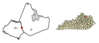
Dover is a home rule-class city in Mason County, Kentucky, United States. The population was 221 at the 2020 census, down from 252 in 2010. It is part of the Maysville Micropolitan Statistical Area.

<span class="mw-page-title-main">Sardis, Kentucky</span> City in Kentucky, United States

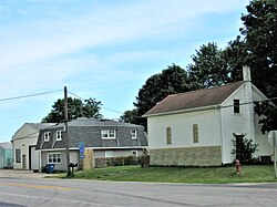
Sardis is a home rule-class city in Mason and Robertson counties in the U.S. state of Kentucky. The population was 60 as of the 2020 census, down from 103 in 2010.

<span class="mw-page-title-main">North Hodge, Louisiana</span> Village in Louisiana, United States

North Hodge is a village in Jackson Parish, Louisiana, United States. The population was 388 at the 2010 census, down from 436 at the 2000 census. It is part of the Ruston Micropolitan Statistical Area.

<span class="mw-page-title-main">Maysville, Missouri</span> City in Missouri, United States

Maysville is a city in DeKalb County, Missouri, United States. The population was 1,095 at the 2020 census. Maysville is the county seat of DeKalb County.

<span class="mw-page-title-main">Hildebran, North Carolina</span> Town in North Carolina, United States

Hildebran is a town in Burke County, North Carolina, United States. The population was 2,023 at the 2010 census. It is part of the Hickory-Lenoir-Morganton Metropolitan Statistical Area.

<span class="mw-page-title-main">Maysville, North Carolina</span> Town in North Carolina, United States

Maysville is a town in Jones County, North Carolina, United States. The population was 818 at the 2020 census. It is part of the New Bern, North Carolina Metropolitan Statistical Area. This town was home to former MLB left fielder Louie Meadows.

<span class="mw-page-title-main">Aberdeen, Ohio</span> Village in Ohio, United States

Aberdeen is a village in Huntington Township, Brown County, Ohio, United States, along the Ohio River 50 miles (80 km) southeast of Cincinnati. The population was 1,638 at the 2010 census.

<span class="mw-page-title-main">Van Buren, Ohio</span> Village in Ohio, United States

Van Buren is a village in Hancock County, Ohio, United States. The population was 328 at the 2010 census.

<span class="mw-page-title-main">Maysville, Oklahoma</span> Town in Oklahoma, United States

Maysville is a town in Garvin and McClain counties, Oklahoma, United States. The population was 1,232 at the 2010 census, down from 1,313 in 2000.

<span class="mw-page-title-main">Petrolia, Pennsylvania</span> Borough in Pennsylvania, United States

Petrolia is a borough in Butler County, Pennsylvania, United States. The population was 212 at the 2010 census.

<span class="mw-page-title-main">Scotland, South Dakota</span> City in South Dakota, United States

Scotland is a city in Bon Homme County, South Dakota, United States. The population was 785 at the 2020 census.

<span class="mw-page-title-main">Bells, Tennessee</span> City in Tennessee, United States

Bells is a city in Crockett County, Tennessee. The population was 2,437 at the 2010 census.

<span class="mw-page-title-main">New Haven, Adams County, Wisconsin</span> Town in Wisconsin, United States

New Haven is a town in Adams County in the U.S. state of Wisconsin. The population was 655 at the 2010 census. The unincorporated community of Big Spring is located in the town.

<span class="mw-page-title-main">Eden (CDP), New York</span> Census-designated place in New York, United States

Eden is a hamlet and census-designated place (CDP) in Erie County, New York, United States. The population was 3,516 at the 2010 census. It is part of the Buffalo–Niagara Falls Metropolitan Statistical Area.

Rice Lake is a town in Barron County in the U.S. state of Wisconsin. The population was 3,041 at the 2010 census. The City of Rice Lake is located mostly within the town. The unincorporated communities of Campia and Dobie are located partially in the town.

References

  1. "2020 U.S. Gazetteer Files". United States Census Bureau. Retrieved March 16, 2022.
  2. 1 2 "2020 Census State Redistricting Data". census.gov. United states Census Bureau. Retrieved August 12, 2021.
  3. "US Gazetteer files: 2010, 2000, and 1990". United States Census Bureau. February 12, 2011. Retrieved April 23, 2011.
  4. "US Gazetteer files 2010". United States Census Bureau. Archived from the original on July 2, 2012. Retrieved May 11, 2012.
  5. "Census of Population and Housing". Census.gov. Archived from the original on April 26, 2015. Retrieved June 4, 2015.
  6. "American FactFinder". United States Census Bureau. Archived from the original on February 12, 2020. Retrieved May 11, 2012.
  7. "American FactFinder". United States Census Bureau. Archived from the original on February 12, 2020. Retrieved January 31, 2008.
  8. "North Scott" (PDF). Iowa Department of Education. Retrieved July 20, 2020.

Commons-logo.svg Media related to Maysville, Iowa at Wikimedia Commons