Audubon County, Iowa

Last updated

Audubon County
Audubon County IA Courthouse.jpg
Audubon County Courthouse in Audubon
Map of Iowa highlighting Audubon County.svg
Location within the U.S. state of Iowa
Iowa in United States.svg
Iowa's location within the U.S.
Coordinates: 41°41′05″N94°54′29″W / 41.684722222222°N 94.908055555556°W / 41.684722222222; -94.908055555556
CountryFlag of the United States.svg United States
StateFlag of Iowa.svg  Iowa
Founded1851
Named for John James Audubon
Seat Audubon
Largest cityAudubon
Area
  Total443 sq mi (1,150 km2)
  Land443 sq mi (1,150 km2)
  Water0.4 sq mi (1 km2)  0.1%
Population
 (2020)
  Total5,674
  Density13/sq mi (4.9/km2)
Time zone UTC−6 (Central)
  Summer (DST) UTC−5 (CDT)
Congressional district 4th
Website www.auduboncountyia.gov

Audubon County is a county in the U.S. state of Iowa. As of the 2020 census, the population was 5,674, [1] making it Iowa's third-least populous county. Its county seat is Audubon. [2] The county was named after John James Audubon, the naturalist and artist. [3]

Contents

History

Audubon County was formed on January 15, 1851, from sections of Pottawattamie County. It was named after John James Audubon. [4] The current Audubon County Court House was opened in 1940. [5]

Geography

According to the U.S. Census Bureau, the county has an area of 443 square miles (1,150 km2), of which 443 square miles (1,150 km2) is land and 0.4 square miles (1.0 km2) (0.1%) is water. [6]

Soils of Audubon County Audubon Co IA Pie Chart No Text Version.pdf
Soils of Audubon County

Major highways

Adjacent counties

Demographics

Historical population
CensusPop.Note
1860 454
1870 1,212167.0%
1880 7,448514.5%
1890 12,41266.6%
1900 13,6269.8%
1910 12,671−7.0%
1920 12,520−1.2%
1930 12,264−2.0%
1940 11,790−3.9%
1950 11,579−1.8%
1960 10,919−5.7%
1970 9,595−12.1%
1980 8,559−10.8%
1990 7,334−14.3%
2000 6,830−6.9%
2010 6,119−10.4%
2020 5,674−7.3%
2023 (est.)5,534 [7] −2.5%
U.S. Decennial Census [8]
1790-1960 [9] 1900-1990 [10]
1990-2000 [11] 2010-2018 [12]
Population of Audubon County from US census data AudubonCountyIowaPop2020.png
Population of Audubon County from US census data

2020 census

The 2020 census recorded a population of 5,674 in the county, with a population density of

2010 census

The 2010 census recorded a population of 6,119 in the county, with a population density of

2000 census

2022 US Census population pyramid for Audubon County from ACS 5-year estimates AudubonCountyIA2022PopPyr.png
2022 US Census population pyramid for Audubon County from ACS 5-year estimates

As of the census [14] of 2000, there were 6,830 people, 2,773 households, and 1,927 families residing in the county. The population density was 15 people per square mile (5.8 people/km2). There were 2,995 housing units at an average density of 7 units per square mile (2.7 units/km2). The racial makeup of the county was 99.17% White, 0.15% Black or African American, 0.09% Native American, 0.19% Asian, 0.03% from other races, and 0.38% from two or more races. 0.48% of the population were Hispanic or Latino of any race.

There were 2,773 households, out of which 30.10% had children under the age of 18 living with them, 61.40% were married couples living together, 5.60% had a female householder with no husband present, and 30.50% were non-families. 28.20% of all households were made up of individuals, and 16.70% had someone living alone who was 65 years of age or older. The average household size was 2.40 and the average family size was 2.94.

In the county, the population was spread out, with 25.90% under the age of 18, 5.00% from 18 to 24, 22.70% from 25 to 44, 22.90% from 45 to 64, and 23.50% who were 65 years of age or older. The median age was 42 years. For every 100 females there were 92.00 males. For every 100 females age 18 and over, there were 89.10 males.

The median income for a household in the county was $32,215, and the median income for a family was $37,288. Males had a median income of $28,090 versus $17,528 for females. The per capita income for the county was $17,489. About 6.70% of families and 7.70% of the population were below the poverty line, including 8.20% of those under age 18 and 7.80% of those age 65 or over.

Communities

Cities

Townships

Audubon County is divided into twelve townships:

Population ranking

The population ranking of the following table is based on the 2020 census of Audubon County. [1] county seat

RankCity/Town/etc.Municipal typePopulation (2020 Census)
1 Audubon City2,053
2 Exira City787
3 Kimballton City291
4 Brayton City143
5 Gray City61

Politics

United States presidential election results for Audubon County, Iowa [15]
Year Republican Democratic Third party
No.%No.%No.%
2020 2,29567.11%1,07131.32%541.58%
2016 2,13662.60%1,08031.65%1965.74%
2012 1,80252.13%1,61146.60%441.27%
2008 1,63447.56%1,73950.61%631.83%
2004 1,95854.51%1,60844.77%260.72%
2000 1,90950.45%1,78047.04%952.51%
1996 1,31437.67%1,82752.38%3479.95%
1992 1,37335.45%1,58941.03%91123.52%
1988 1,47843.84%1,86355.27%300.89%
1984 2,30654.97%1,85444.20%350.83%
1980 2,52357.96%1,54635.52%2846.52%
1976 1,97847.86%2,10450.91%511.23%
1972 2,51561.61%1,53337.56%340.83%
1968 2,59257.55%1,71037.97%2024.48%
1964 1,87138.30%3,01161.64%30.06%
1960 2,93553.05%2,59546.91%20.04%
1956 3,05754.16%2,58545.80%20.04%
1952 3,60561.85%2,22038.09%40.07%
1948 2,17742.25%2,84055.11%1362.64%
1944 2,34643.07%3,09456.80%70.13%
1940 2,63244.80%3,23655.08%70.12%
1936 2,34440.14%3,44859.05%470.80%
1932 1,60434.62%2,98664.45%430.93%
1928 2,34049.44%2,36449.95%290.61%
1924 2,47553.86%96521.00%1,15525.14%
1920 2,96367.68%1,40532.09%100.23%
1916 1,58155.61%1,24743.86%150.53%
1912 69226.15%96336.39%99137.45%
1908 1,70160.86%1,05037.57%441.57%
1904 1,84364.99%93432.93%592.08%
1900 1,82157.86%1,30141.34%250.79%
1896 1,70554.14%1,41745.00%270.86%

See also

Related Research Articles

<span class="mw-page-title-main">Shelby County, Iowa</span> County in Iowa, United States

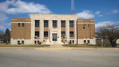
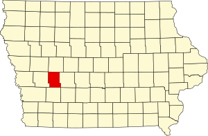
Shelby County is a county located in the U.S. state of Iowa. As of the 2020 census, the population was 11,746. The county seat is Harlan. Its name is in honor of Isaac Shelby, the first Governor of Kentucky.

<span class="mw-page-title-main">Wapello County, Iowa</span> County in Iowa, United States

Wapello County is a county located in the U.S. state of Iowa. As of the 2020 census, the population was 35,437. The county seat is Ottumwa. The county was formed on February 17, 1843, and named for Wapello, a Meskwaki chief.

<span class="mw-page-title-main">Taylor County, Iowa</span> County in Iowa, United States

Taylor County is a county located in the U.S. state of Iowa. As of the 2020 census, the population was 5,896, making it the fourth-least populous county in Iowa. The county seat is Bedford. The county was formed in 1847 and named after General and President Zachary Taylor.

<span class="mw-page-title-main">Kossuth County, Iowa</span> County in Iowa, United States

Kossuth County is a county in the U.S. state of Iowa. As of the 2020 census, the population was 14,828. The county seat is Algona.

<span class="mw-page-title-main">Guthrie County, Iowa</span> County in Iowa, United States

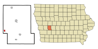
Guthrie County is a county located in the U.S. state of Iowa. As of the 2020 census, the population was 10,623. The county seat is Guthrie Center. The county was formed on January 15, 1851, and named after Captain Edwin B. Guthrie, who died in the Mexican–American War.

<span class="mw-page-title-main">Greene County, Iowa</span> County in Iowa, United States

Greene County is a county located in the U.S. state of Iowa. As of the 2020 census, the population was 8,771. The county seat is Jefferson. The county is named in honor of General Nathanael Greene.

<span class="mw-page-title-main">Cedar County, Iowa</span> County in Iowa, United States

Cedar County is a county located in the U.S. state of Iowa. As of the 2020 census, the population was 18,505. Its county seat is Tipton. The county is named for the Cedar River, which runs through the county.

<span class="mw-page-title-main">Carroll County, Iowa</span> County in Iowa, United States

Carroll County is a county located in the U.S. state of Iowa. As of the 2020 census, the population was 20,760. Its county seat is Carroll. The county is named in honor of Charles Carroll of Carrollton, signer of the Declaration of Independence.

<span class="mw-page-title-main">Audubon, Iowa</span> City in Iowa, United States

Audubon is a city and the county seat in Audubon County, Iowa, United States. The population was 2,053 in the 2020 census, a decline from 2,382 in the 2000 census.

<span class="mw-page-title-main">Brayton, Iowa</span> City in Iowa, United States

Brayton is a city in Audubon County, Iowa, United States, along the East Nishnabotna River. The population was 143 at the 2020 census.

<span class="mw-page-title-main">Exira, Iowa</span> City in Iowa, United States

Exira is a city in Audubon County, Iowa, United States, along the East Nishnabotna River and U.S. Route 71. The population was 787 at the time of the 2020 census.

<span class="mw-page-title-main">Gray, Iowa</span> City in Iowa, United States

Gray is a city in Audubon County, Iowa, United States, along the East Branch of the West Nishnabotna River. The population was 61 at the time of the 2020 census.

<span class="mw-page-title-main">Kimballton, Iowa</span> City in Iowa, United States

Kimballton is a city in Audubon County, Iowa, United States. The population was 291 at the time of the 2020 census.

<span class="mw-page-title-main">Hudson, Iowa</span> City in Iowa, United States

Hudson is a city in Black Hawk County, Iowa, United States. The population was 2,546 at the time of the 2020 census. The rural community of Hudson has grown in recent years and is included as a part of the Waterloo-Cedar Falls Metropolitan Statistical Area.

<span class="mw-page-title-main">Wallingford, Iowa</span> City in Iowa, United States

Wallingford is a city in Emmet County, Iowa, United States. The population was 197 at the 2010 census.

<span class="mw-page-title-main">Onslow, Iowa</span> City in Iowa, United States

Onslow is a city in Jones County, Iowa, United States. The population was 201 at the time of the 2020 census. It is part of the Cedar Rapids Metropolitan Statistical Area.

<span class="mw-page-title-main">Rodman, Iowa</span> City in Iowa, United States

Rodman is a city in Palo Alto County, Iowa, United States. The population was 31 at the time of the 2020 census. Rodman is also the farthest city in Iowa from any National park, being 372 miles away from the closest National park in the United States.

<span class="mw-page-title-main">Elk Horn, Iowa</span> City in Iowa, United States

Elk Horn is a city in Shelby County, Iowa, United States. The population was 601 at the time of the 2020 census. Elk Horn is known as an enclave of Danish ethnicity and is home to the Museum of Danish America.

<span class="mw-page-title-main">Vincent, Iowa</span> City in Iowa, United States

Vincent is a city in Webster County, Iowa, United States. The population was 130 at the time of the 2020 census.

<span class="mw-page-title-main">Greenbush, Wisconsin</span> Town in Wisconsin, United States

Greenbush is a town in Sheboygan County, Wisconsin, United States. The population was 2,773 at the 2000 census. It is included in the Sheboygan, Wisconsin Metropolitan Statistical Area. The census-designated place of Greenbush is located in the town. The unincorporated community of German Corners is also located in the town.

References

  1. 1 2 3 "2020 Census State Redistricting Data". census.gov. United states Census Bureau. Retrieved August 12, 2021.
  2. "Find a County". National Association of Counties. Archived from the original on May 31, 2011. Retrieved June 7, 2011.
  3. Stennett, William H. (1908). A History of the Origin of the Place Names: Connected With the Chicago North Western and Chicago, St. Paul, Minneapolis Omaha Railways (2nd ed.). Chicago. p.  23 . Retrieved April 5, 2019.{{cite book}}: CS1 maint: location missing publisher (link)
  4. Andrews, Henry Franklin (1915). History of Audubon County, Iowa: Its People, Industries, and Institutions. Brookhaven Press. p. 46. ISBN   9781581032413. (History of Audubon County, Iowa at the Internet Archive )
  5. "Audubon County Courthouse". Iowa Judicial Branch. Archived from the original on July 26, 2011. Retrieved February 9, 2011.
  6. "US Gazetteer files: 2010, 2000, and 1990". United States Census Bureau. February 12, 2011. Retrieved April 23, 2011.
  7. "Annual Estimates of the Resident Population for Counties: April 1, 2020 to July 1, 2023". United States Census Bureau. Retrieved April 2, 2024.
  8. "U.S. Decennial Census". United States Census Bureau. Retrieved July 13, 2014.
  9. "Historical Census Browser". University of Virginia Library. Retrieved July 13, 2014.
  10. "Population of Counties by Decennial Census: 1900 to 1990". United States Census Bureau. Retrieved July 13, 2014.
  11. "Census 2000 PHC-T-4. Ranking Tables for Counties: 1990 and 2000" (PDF). United States Census Bureau. Archived (PDF) from the original on March 27, 2010. Retrieved July 13, 2014.
  12. "State & County QuickFacts". United States Census Bureau. Archived from the original on June 7, 2011. Retrieved July 13, 2014.
  13. "Population and Housing Occupancy Status: 2010 - State County". United States Census Bureau American FactFinder. Archived from the original on September 29, 2015. Retrieved March 6, 2011.[ dead link ]
  14. "U.S. Census website". United States Census Bureau . Retrieved January 31, 2008.
  15. Leip, David. "Dave Leip's Atlas of U.S. Presidential Elections". uselectionatlas.org. Retrieved April 25, 2018.

Further reading

41°41′05″N94°54′29″W / 41.68472°N 94.90806°W / 41.68472; -94.90806