Clayton County, Iowa

Last updated

Clayton County
Snow on road, Clayton County, Iowa.JPG
Winter scene near Elkader
Map of Iowa highlighting Clayton County.svg
Location within the U.S. state of Iowa
Iowa in United States.svg
Iowa's location within the U.S.
Coordinates: 42°50′37″N91°20′36″W / 42.843611111111°N 91.343333333333°W / 42.843611111111; -91.343333333333
CountryFlag of the United States.svg United States
StateFlag of Iowa.svg  Iowa
Founded1837
Named for John M. Clayton
Seat Elkader
Largest city Guttenberg
Area
  Total793 sq mi (2,050 km2)
  Land779 sq mi (2,020 km2)
  Water14 sq mi (40 km2)  1.8%
Population
 (2020)
  Total17,043
  Density21/sq mi (8.3/km2)
Time zone UTC−6 (Central)
  Summer (DST) UTC−5 (CDT)
Congressional district 1st
Website www.claytoncountyia.gov

Clayton County is a county located in the U.S. state of Iowa. As of the 2020 census, the population was 17,043. [1] Its county seat is Elkader. [2] The county was established in 1837 and was named in honor of John M. Clayton, [3] United States Senator from Delaware and later Secretary of State under President Zachary Taylor.

Contents

Geography

Route W68 shield Clayton County Route W68 IA.svg
Route W68 shield

According to the U.S. Census Bureau, the county has a total area of 793 square miles (2,050 km2), of which 779 square miles (2,020 km2) is land and 14 square miles (36 km2) (1.8%) is water. [4] It is the fifth-largest county in Iowa by area.

Adjacent counties

Major highways

National protected areas

Geology

Clayton County is part of the Driftless Area, a region that completely missed being ice-covered during the last ice age. Streams have deeply carved valleys, while the Mississippi River has spectacular bluffs.

Demographics

Historical population
CensusPop.Note
1850 3,873
1860 20,728435.2%
1870 27,77134.0%
1880 28,8293.8%
1890 26,733−7.3%
1900 27,7503.8%
1910 25,576−7.8%
1920 25,032−2.1%
1930 24,559−1.9%
1940 24,334−0.9%
1950 22,522−7.4%
1960 21,962−2.5%
1970 20,606−6.2%
1980 21,0982.4%
1990 19,054−9.7%
2000 18,678−2.0%
2010 18,129−2.9%
2020 17,043−6.0%
2023 (est.)16,969 [5] −0.4%
U.S. Decennial Census [6]
1790-1960 [7] 1900-1990 [8]
1990-2000 [9] 2010-2018 [10]
Population of Clayton County from US census data ClaytonCountyIowaPop2020.png
Population of Clayton County from US census data

2020 census

2022 US Census population pyramid for Clayton County from ACS 5-year estimates ClaytonCountyIA2022PopPyr.png
2022 US Census population pyramid for Clayton County from ACS 5-year estimates

The 2020 census recorded a population of 17,043 in the county, with a population density of

2010 census

The 2010 census recorded a population of 18,130 in the county, with a population density of

2000 census

As of the census [12] of 2000, there were 18,678 people, about 7,500 households, and 1 family residing in the county. The population density was 24 people per square mile (9.3 people/km2). There were 8,620 housing units at an average density of 11 units per square mile (4.2 units/km2). The racial makeup of the county was 98.93% White, 0.14% Black or African American, 0.22% Native American, 0.11% Asian, 0.01% Pacific Islander, 0.19% from other races, and 0.41% from two or more races. 0.76% of the population were Hispanic or Latino of any race.

There were 7,375 households, out of which 30.90% had children under the age of 18 living with them, 59.70% were married couples living together, 6.10% had a female householder with no husband present, and 30.40% were non-families. 26.30% of all households were made up of individuals, and 13.30% had someone living alone who was 65 years of age or older. The average household size was 2.47 and the average family size was 2.98.

In the county, the population was spread out, with 25.40% under the age of 18, 6.50% from 18 to 24, 26.00% from 25 to 44, 23.60% from 45 to 64, and 18.50% who were 65 years of age or older. The median age was 40 years. For every 100 females, there were 97.60 males. For every 100 females age 18 and over, there were 95.50 males.

The median income for a household in the county was $34,068, and the median income for a family was $40,199. Males had a median income of $27,165 versus $19,644 for females. The per capita income for the county was $16,930. About 5.70% of families and 8.60% of the population were below the poverty line, including 9.60% of those under age 18 and 9.40% of those age 65 or over.

Communities

Cities

Unincorporated communities

Townships

Clayton County is divided into these townships:

Population ranking

The population ranking of the following table is based on the 2020 census of Clayton County. [1]

county seat

RankCity/Town/etc.Population (2020 Census)
1 Postville (partially in Allamakee County )2,503
2 Guttenberg 1,817
3 Monona 1,471
4 Elkader 1,209
5 Strawberry Point 1,155
6 Edgewood (partially in Delaware County )909
7 Garnavillo 763
8 McGregor 742
9 Marquette 429
10 Luana 301
11 Farmersburg 271
12 Volga 203
13 North Buena Vista 109
14 St. Olaf 106
15 Garber 76
16 Clayton 45
17 Osterdock 43
18 Elkport 29

Politics

United States presidential election results for Clayton County, Iowa [13]
Year Republican Democratic Third party
No.%No.%No.%
2020 6,10663.64%3,34034.81%1481.54%
2016 5,31758.24%3,23735.46%5756.30%
2012 4,16445.57%4,80652.59%1681.84%
2008 3,65140.61%5,19557.79%1441.60%
2004 4,31247.03%4,73651.66%1201.31%
2000 4,03447.07%4,23849.45%2993.49%
1996 2,94435.93%4,28452.28%96611.79%
1992 3,04433.12%3,74240.72%2,40426.16%
1988 3,83946.58%4,32052.41%831.01%
1984 5,02958.80%3,44640.29%780.91%
1980 5,11555.56%3,29735.81%7948.62%
1976 4,82654.80%3,80443.19%1772.01%
1972 5,44760.20%3,36637.20%2352.60%
1968 5,13257.81%3,16835.68%5786.51%
1964 3,92341.08%5,62458.89%30.03%
1960 6,44158.25%4,61241.71%40.04%
1956 6,52959.76%4,38440.12%130.12%
1952 7,66967.22%3,73032.70%90.08%
1948 5,15150.94%4,85748.04%1031.02%
1944 5,85557.61%4,25941.91%490.48%
1940 7,44359.86%4,97340.00%180.14%
1936 5,01741.00%6,73155.01%4883.99%
1932 3,72533.46%7,34765.99%620.56%
1928 6,77461.28%4,23138.28%490.44%
1924 4,16841.48%1,55615.48%4,32543.04%
1920 6,74777.50%1,80820.77%1511.73%
1916 3,34757.54%2,37940.90%911.56%
1912 1,23921.14%2,91949.80%1,70329.06%
1908 2,77347.04%3,02651.33%961.63%
1904 3,33954.59%2,62842.96%1502.45%
1900 3,36653.07%2,88445.47%921.45%
1896 3,30252.16%2,91045.96%1191.88%

See also

Related Research Articles

<span class="mw-page-title-main">Burt County, Nebraska</span> County in Nebraska, United States

Burt County is a county in the U.S. state of Nebraska, bordering the west bank of the upper Missouri River. As of the 2020 United States Census, the population was 6,722. Its county seat is Tekamah. The county was formed in 1854 and named after Francis Burt, the first governor of Nebraska Territory.

<span class="mw-page-title-main">Woodbury County, Iowa</span> County in Iowa, United States

Woodbury County is a county located in the U.S. state of Iowa. As of the 2020 census, the population was 105,941, making it the sixth-most populous county in Iowa. The county seat is Sioux City.

<span class="mw-page-title-main">Winneshiek County, Iowa</span> County in Iowa, United States

Winneshiek County is a county located in the U.S. state of Iowa. As of the 2020 census, the population was 20,070. The county seat is Decorah.

<span class="mw-page-title-main">Taylor County, Iowa</span> County in Iowa, United States

Taylor County is a county located in the U.S. state of Iowa. As of the 2020 census, the population was 5,896, making it the fourth-least populous county in Iowa. The county seat is Bedford. The county was formed in 1847 and named after General and President Zachary Taylor.

<span class="mw-page-title-main">Monona County, Iowa</span> County in Iowa, United States

Monona County is a county located in the U.S. state of Iowa. As of the 2020 census, the population was 8,751. The county seat is Onawa.

<span class="mw-page-title-main">Harrison County, Iowa</span> County in Iowa, United States

Harrison County is a county located in the U.S. state of Iowa. As of the 2020 census, the population was 14,582. The county seat is Logan. The county was formed in 1851. It was named for the ninth US President William Henry Harrison.

<span class="mw-page-title-main">Crawford County, Iowa</span> County in Iowa, United States

Crawford County is a county located in the U.S. state of Iowa. As of the 2020 census, the population was 16,525. Its county seat is Denison. The county was named for William Harris Crawford, U.S. senator from Georgia and United States Secretary of the Treasury.

<span class="mw-page-title-main">Buchanan County, Iowa</span> County in Iowa, United States

Buchanan County is a county located in the U.S. state of Iowa. As of the 2020 census, the population was 20,565. Its county seat is Independence. The county was created in 1837 and was named in honor of Senator James Buchanan, the 15th President of the United States.

<span class="mw-page-title-main">Allamakee County, Iowa</span> County in Iowa, United States

Allamakee County is the northeasternmost county in the U.S. state of Iowa. As of the 2020 census, the population was 14,061. Its county seat is Waukon.

<span class="mw-page-title-main">Lansing, Iowa</span> City in Iowa, United States

Lansing is a city in Lansing Township, Allamakee County, Iowa, United States. The population was 968 at the time of the 2020 census.

<span class="mw-page-title-main">Clayton, Iowa</span> City in Iowa, United States

Clayton is a city in Clayton County, Iowa, United States. The population was 45 at the 2020 census, down from 55 in 2000. Clayton is located directly on the Mississippi River and is only accessible via a very steep road.

<span class="mw-page-title-main">Elkader, Iowa</span> City in Iowa, United States

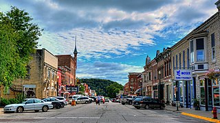
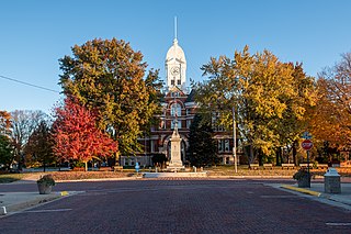
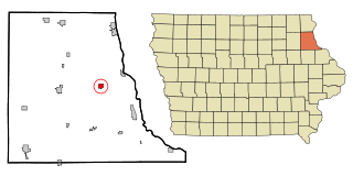
Elkader is a city in Clayton County, Iowa, United States. The population was 1,209 at the time of the 2020 census, down from 1,465 in 2000. It is the county seat of Clayton County. It is the site of Iowa's lowest recorded minimum temperature, −44 °C (−47 °F) on February 3, 1996.

<span class="mw-page-title-main">Farmersburg, Iowa</span> City in Iowa, United States

Farmersburg is a city in Clayton County, Iowa, United States. The population was 271 at the time of the 2020 census, down from 300 in 2000. The current Mayor is Glenn Radloff, a cross-country truck driver.

<span class="mw-page-title-main">Garnavillo, Iowa</span> City in Iowa, United States

Garnavillo is a city in Clayton County, Iowa, United States. The population was 763 at the time of the 2020 census, up from 754 in 2000.

<span class="mw-page-title-main">Littleport, Iowa</span> Unincorporated Community in Iowa, United States

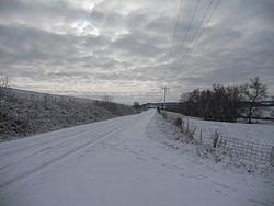
Littleport is an unincorporated community and former city in Clayton County, Iowa, United States. After the Volga River flood of May 16, 1999, much of the town was destroyed and most residents moved away. At the 2000 Census, there were 26 residents. As of the 1960 Census, there had been 119 residents. There had been 139 people in 1950 and more than 200 people in 1916. The town was laid out in 1857 by Dennis Quigley and platted on May 21, 1860, but remained of little importance until the coming of the railroad in 1874. The town was not officially incorporated until 1907. Around this time, it had three general stores, a bank, blacksmith shop, Catholic church, German Lutheran church, an independent school district and a creamery. Somewhat later, it also had two taverns. It was officially disincorporated in 2005.

<span class="mw-page-title-main">Monona, Iowa</span> City in Iowa, United States

Monona is a city in Clayton County, Iowa, United States. The population was 1,471 at the time of the 2020 census.

<span class="mw-page-title-main">Blencoe, Iowa</span> City in Iowa, United States

Blencoe is a city in Monona County, Iowa, United States. The population was 233 at the 2020 census.

<span class="mw-page-title-main">Moorhead, Iowa</span> City in Iowa, United States

Moorhead is a city in Monona County, Iowa, United States. Moorhead stands along the Soldier River. The population was 199 at the time of the 2020 census.

<span class="mw-page-title-main">Soldier, Iowa</span> City in Iowa, United States

Soldier is a city in Monona County, Iowa, United States, along the Soldier River. The population was 184 at the time of the 2020 census.

<span class="mw-page-title-main">Ute, Iowa</span> City in Iowa, United States

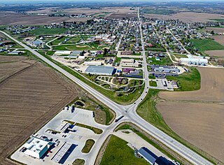
Ute is a city in Monona County, Iowa, United States, along the Soldier River. The population was 338 at the time of the 2020 census.

References

  1. 1 2 3 "2020 Census State Redistricting Data". census.gov. United states Census Bureau. Retrieved August 12, 2021.
  2. "Find a County". National Association of Counties. Archived from the original on May 31, 2011. Retrieved June 7, 2011.
  3. Gannett, Henry (1905). The Origin of Certain Place Names in the United States. Govt. Print. Off. pp.  84.
  4. "US Gazetteer files: 2010, 2000, and 1990". United States Census Bureau. February 12, 2011. Retrieved April 23, 2011.
  5. "Annual Estimates of the Resident Population for Counties: April 1, 2020 to July 1, 2023". United States Census Bureau. Retrieved April 2, 2024.
  6. "U.S. Decennial Census". United States Census Bureau. Retrieved July 14, 2014.
  7. "Historical Census Browser". University of Virginia Library. Archived from the original on August 11, 2012. Retrieved July 14, 2014.
  8. "Population of Counties by Decennial Census: 1900 to 1990". United States Census Bureau. Retrieved July 14, 2014.
  9. "Census 2000 PHC-T-4. Ranking Tables for Counties: 1990 and 2000" (PDF). United States Census Bureau. Archived (PDF) from the original on March 27, 2010. Retrieved July 14, 2014.
  10. "State & County QuickFacts". United States Census Bureau. Archived from the original on June 7, 2011. Retrieved July 14, 2014.
  11. "Population and Housing Occupancy Status: 2010 - State County". United States Census Bureau American FactFinder. Archived from the original on September 29, 2015. Retrieved March 12, 2011.[ dead link ]
  12. "U.S. Census website". United States Census Bureau . Retrieved January 31, 2008.
  13. Leip, David. "Dave Leip's Atlas of U.S. Presidential Elections". uselectionatlas.org. Retrieved April 25, 2018.

42°50′37″N91°20′36″W / 42.84361°N 91.34333°W / 42.84361; -91.34333