
This is a list of properties and historic districts in Iowa that are listed on the National Register of Historic Places. There are listings in all of Iowa's 99 counties, adding up to over 2,300 total.

Moore State Park is a 737-acre (298 ha) public recreation area located in the town of Paxton, Massachusetts, portions of which were listed on the National Register of Historic Places as the Moore State Park Historic District in 2004. Features of the state park include historical building foundations, a restored sawmill, Eames Pond, waterfalls and mill chutes as well as abundant azaleas, rhododendrons, and mountain laurel. The park is managed by the Massachusetts Department of Conservation and Recreation.

The Jarrell Plantation State Historic Site is a former cotton plantation and state park in Juliette, Georgia, United States. Founded as a forced-labor farm worked by the Jarrell family and the African American people they enslaved, the site stands today as one of the best-preserved examples of a "middle class" Southern plantation. The Jarrell Plantation's buildings and artifacts all came from the Jarrell family, who farmed the land for over 140 years. Located in the red clay hills of the Georgia piedmont, It was added to the National Register of Historic Places in 1973. It is a Georgia state park in Jones County.

The Graue Mill is a water-powered grist mill that was originally erected in 1852. Now a museum, it is one of two operating water-powered gristmills in Illinois. It is located on Salt Creek in Oak Brook, Illinois, owned by the Forest Preserve District of DuPage County and operated by a nonprofit preservationist group.

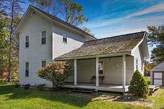
The James P. Hidley Cottage is a small Carpenter Gothic house in western Butler County, Ohio, United States. Erected in 1860, the house is important as one of the area's few houses of its style, and it has been named a historic site.

Troy Mills is an unincorporated community in northern Linn County, Iowa, United States. It lies along local roads north of the city of Cedar Rapids, the county seat of Linn County. Its elevation is 869 feet (265 m). Although Troy Mills is unincorporated, it has a post office, with the ZIP code of 52344, which opened on 10 June 1867, and a full volunteer fire department.

George Washington's Gristmill was part of the original Mount Vernon plantation, constructed during the lifetime of the United States' first president. The original structure was destroyed about 1850. The Commonwealth of Virginia and the Mount Vernon Ladies’ Association have reconstructed the gristmill and the adjacent distillery. The reconstructed buildings are located at their original site three miles (5 km) west of Mount Vernon proper near Woodlawn Plantation in Alexandria, Virginia. Because the reconstructed buildings embody the distinctive characteristics of late eighteenth century methods of production and are of importance to the history of Virginia, the site is listed on the National Register of Historic Places despite the fact that the buildings are not original.

This is a list of the National Register of Historic Places listings in Clayton County, Iowa.

The Hemlock Glen Industrial Archeological District is a historic industrial archaeological site in Hampton, Connecticut. It consists of a series of mill sites on a tributary of the Shetucket River that operated from the mid-18th to early 20th centuries. The district was added to the National Register of Historic Places in 2007.

Bruyn Estate at Red Mills Farm or "Miller's House at Red Mills Farm" is a historic estate and farm located in Shawangunk in Ulster County, New York. Situated on just under 30 acres, Bruyn Estate has two residential dwellings totaling eight bedrooms. It is on the east side of the Shawangunk Kill at the Ulster/Orange Counties line. Wallkill Avenue is north of the building with the Shawangunk Kill east of it.

Thorp Mill is a historic building located in Thorp, Washington, United States.

The Pine Mill Bridge is an historic structure located in Wildcat Den State Park in rural Muscatine County, Iowa, United States. It was built in 1878 near the Pine Creek Gristmill, the only place in Iowa where a mill and bridge combination remains in place. The bridge was listed on the National Register of Historic Places in 1998 as a part of the Highway Bridges of Iowa MPS.

Beeds Lake State Park is located northwest of Hampton, Iowa, United States. It was listed has a historic district on the National Register of Historic Places as Beeds Lake State Park, Civilian Conservation Corps Area in 1990. At the time of its nomination it contained 21 resources, which included one contributing building, 15 contributing structures, and five non-contributing structures. The 319-acre (129 ha) park surrounds a 99-acre (40 ha) reservoir. It features hiking trails, boating, fishing, swimming, camping, picnic areas and shelters, lodges and concessions.

The Motor Mill Historic District is a nationally recognized historic district located southeast of Elkader, Iowa, United States. It was listed on the National Register of Historic Places in 2014. In 1977 it had been listed as a contributing property in the Motor Townsite.
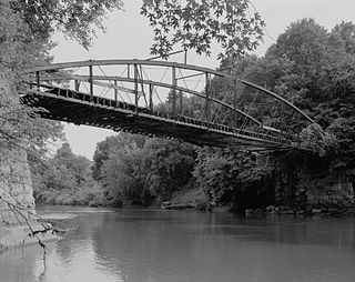
Corbett's/Eby's Mill Bridge is a historic structure located northeast of Scotch Grove, Iowa, United States. It spans the Maquoketa River for 128 feet (39 m). James S. Applegate established a gristmill near this location in 1858. He was joined by John Corbett, who obtained ownership by 1868 and expanded the operation and added a sawmill. He petitioned the Jones County Board of Supervisors for an iron bridge at this location in 1870. They agreed to pay two-thirds of the construction costs with the final third paid for by local subscriptions. The contract to construct this bridge and a similar span in Monticello was made with Miller, Jamison & Company of Cleveland. Both are single span bowstring truss bridges that were completed in November 1871. This bridge has always been identified with the mill. Samuel Eby acquired it in 1875, and it remained in the family until 1913. The bridge was originally on a loop road that circled behind the mill pond. When County Road X73 was created in 1958 it bypassed the bridge to the south. The bridge has been under private ownership ever since. It was listed on the National Register of Historic Places in 1985.

The Huron City Historic District is a historic district encompassing the village of Huron City, Michigan, with structures located primarily along Pioneer Drive. The district was listed on the National Register of Historic Places in 1995.
The Fallasburg Historic District is a historic district containing the remaining portions of a nineteenth century hamlet surrounding the remains of a sawmill and gristmill. The district is located near the Fallasburg Bridge, where Covered Bridge Road crosses the Flat River in Vergennes Township, Michigan. It was listed on the National Register of Historic Places in 1999.
Notbohm Mill Archaeological District, designated 13LN296 in the state archaeological inventory, is a nationally recognized historic district located west of Alburnett, Iowa, United States. It includes the remnants of the mill's foundation, the mill race, and the now-dry mill pond along the east branch of Otter Creek. This was both a grist mill and a sawmill operation. The mill began operating in the late 1860s. Frederick Notbohm began building the mill facility, which is the subject of this district, in 1875 near the now-defunct town of Lafayette. It continued to operate into the late 1930s and the mill itself continued to stand into the 1970s when it collapsed. The historic district was listed on the National Register of Historic Places in 2000.
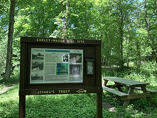
The Gurley-Mason Mill was a historic sawmill and gristmill located along the Fenton River on the north side of Old Turnpike Road in Mansfield, Connecticut. The mill was built around 1778, shut down around 1935, and demolished in the mid-1960s. The 2.31-acre site and ruins have been conserved by Joshua's Tract Conservation and Historic Trust since 2000. The Gurleyville Historic District lies two miles downriver.


