Marion Township | |
---|---|
Township | |
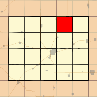
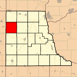
![]() Location in Clayton County | |
Coordinates: 42°57′09″N091°32′47″W / 42.95250°N 91.54639°W Coordinates: 42°57′09″N091°32′47″W / 42.95250°N 91.54639°W | |
Country | ![]() |
State | ![]() |
County | Clayton |
Area | |
• Total | 35.87 sq mi (92.89 km2) |
• Land | 35.87 sq mi (92.89 km2) |
• Water | 0 sq mi (0 km2) 0% |
Elevation | 958 ft (292 m) |
Population (2000) | |
• Total | 389 |
• Density | 10.8/sq mi (4.2/km2) |
GNIS feature ID | 0468349 |
Marion Township is a township in Clayton County, Iowa, USA. As of the 2000 census, its population was 389.
A civil township is a widely used unit of local government in the United States that is subordinate to a county. The term town is used in New England, New York, and Wisconsin to refer to the equivalent of the civil township in these states. Specific responsibilities and the degree of autonomy vary based on each state. Civil townships are distinct from survey townships, but in states that have both, the boundaries often coincide and may completely geographically subdivide a county. The U.S. Census Bureau classifies civil townships as minor civil divisions. Currently, there are 20 states with civil townships.
Clayton County is a county located in the U.S. state of Iowa. As of the 2010 census, the population was 18,129. Its county seat is Elkader. The county was established in 1837 and was named in honor of John M. Clayton, United States Senator from Delaware and later Secretary of State under President Zachary Taylor.
Iowa is a state in the Midwestern United States, bordered by the Mississippi River to the east and the Missouri River and Big Sioux River to the west. It is bordered by six states; Wisconsin to the northeast, Illinois to the east, Missouri to the south, Nebraska to the west, South Dakota to the northwest and Minnesota to the north.
Marion Township covers an area of 35.87 square miles (92.9 km2) and contains no incorporated settlements. According to the USGS, it contains five cemeteries: Apostolic, Cook, Houg, Marion Lutheran and Mork.
The United States Geological Survey is a scientific agency of the United States government. The scientists of the USGS study the landscape of the United States, its natural resources, and the natural hazards that threaten it. The organization has four major science disciplines, concerning biology, geography, geology, and hydrology. The USGS is a fact-finding research organization with no regulatory responsibility.
The streams of Deer Creek and Sand Creek run through this township.
Guilford Township is one of twelve townships in Hendricks County, Indiana, United States. As of the 2010 census, its population was 27,844.
Washington Township is one of twelve townships in Hendricks County, Indiana, United States. As of the 2010 census, its population was 44,764.
Clay Township is one of nine townships in Hamilton County, Indiana, United States. As of the 2010 census, its population was 83,293 and it contained 32,375 housing units. With the annexation of Home Place, Indiana, Carmel, became completely coterminous with the township.
Center Township is one of thirteen townships in Grant County, Indiana, United States. As of the 2010 census, its population was 23,406 and it contained 10,189 housing units. It is home to the Veterans Administration Medical Center.
Monroe Township is one of thirteen townships in Grant County, Indiana, United States. As of the 2010 census, its population was 1,677 and it contained 669 housing units.
Marion Township is one of twelve townships in Buchanan County, Missouri, USA. As of the 2000 census, its population was 1,226.
Stockholm Township is a township in Crawford County, Iowa, USA. As of the 2000 census, its population was 231.
Marion Township is a township in Bourbon County, Kansas, USA. As of the 2000 census, its population was 1,165.
Marion Township is a township in Doniphan County, Kansas, USA. As of the 2000 census, its population was 226.
Clinton Township is a township in Douglas County, Kansas, USA. As of the 2000 census, its population was 531. It took its name from Clinton, Illinois.
Marion Township is a township in Douglas County, Kansas, USA. As of the 2000 census, its population was 836. It was named after the former town of Marion which in turn was named after Francis Marion.
Willow Springs Township is a township in Douglas County, Kansas, USA. As of the 2000 census, its population was 1,409. Willow Springs Township was formed in 1856. It was named after a small watering stop along the Santa Fe Trail.
Ellsworth Township is a township in Ellsworth County, Kansas, USA. As of the 2000 census, its population was 797.
Jefferson Township is a township in Clayton County, Iowa, USA. As of the 2000 census, its population was 2,721.
Deep Creek Township is a township in Clinton County, Iowa, USA. As of the 2000 census, its population was 713.
Ottawa Township is a township in Franklin County, Kansas, USA. As of the 2000 census, its population was 868.
Spring Creek Township is a township in Greenwood County, Kansas, USA. As of the 2000 census, its population was 154.
Fox River Township is a township in Davis County, Iowa, USA. As of the 2000 census, its population was 330.
Marion Township is a township in Davis County, Iowa, USA. As of the 2000 census, its population was 218.
Soap Creek Township is a township in Davis County, Iowa, USA. As of the 2000 census, its population was 610.
![]() | This article about the geography of Clayton County, Iowa is a stub. You can help Wikipedia by expanding it. |