McGregor, Iowa

Last updated
McGregor, Iowa
McGregor Iowa.jpg
Clayton County Iowa Incorporated and Unincorporated areas McGregor Highlighted.svg
Location of McGregor, Iowa
Coordinates: 43°1′19″N91°10′47″W / 43.02194°N 91.17972°W / 43.02194; -91.17972 Coordinates: 43°1′19″N91°10′47″W / 43.02194°N 91.17972°W / 43.02194; -91.17972
Country Flag of the United States.svg  United States
State Flag of Iowa.svg  Iowa
County Clayton
Area
[1]
  Total1.30 sq mi (3.36 km2)
  Land1.29 sq mi (3.35 km2)
  Water0.00 sq mi (0.00 km2)
Elevation
692 ft (211 m)
Population
 (2020)
  Total742
  Density573.42/sq mi (221.41/km2)
Time zone UTC-6 (Central (CST))
  Summer (DST) UTC-5 (CDT)
ZIP code
52157
Area code 563
FIPS code 19-48000
GNIS feature ID0458913

McGregor is a city in Clayton County, Iowa, United States. The population was 742 at the time of the 2020 census. [2] McGregor is located on the Mississippi River across from Prairie du Chien, Wisconsin. Pike's Peak State Park is located just south of the city. Just to the north of McGregor is the city of Marquette. The community of McGregor Heights lies in the southern parts of the city limits.

Contents

History

McGregor in 1870 McGregor Iowa 1870.jpg
McGregor in 1870

McGregor was founded as MacGregor's Landing in 1847 by Alexandar MacGregor, a descendant of Rob Roy MacGregor, and the area around MacGregor's Landing was settled by the extended family. In 1849 it was reported that the original MacGregor seal and signet were owned by Alex MacGregor. The Scots Gaelic clan seal was inscribed, "S' Riogal Mo Dhream/ Een dhn bait spair nocht", which was interpreted as "Royalty is my race / End do and spare not". The signet was a bloodstone from Loch Lomond, and was sketched by William Williams. [3]

Since 1837, MacGregor had been operating a ferry across the Mississippi River between Prairie du Chien, Wisconsin and the present site of McGregor, Iowa. MacGregor planned the new city as a six block development, and it was quickly populated, being incorporated as McGregor in 1857. In that same year, the Milwaukee & Mississippi Railroad finished building a railroad track from Milwaukee, Wisconsin to Prairie du Chien, Wisconsin, thus connecting Lake Michigan with the Mississippi River by rail. McGregor quickly became a major commercial center, and served as a hub where grain from Iowa and Minnesota could be transported across the Mississippi and sent on to Milwaukee via railroad. For example, around 1860, Joseph "Diamond Jo" Reynolds moved to McGregor in order to establish a grain trading business, and later ran his own steam packets. [4] The Diamond Jo office building still stands in the city. More railroads were built to connect McGregor with cities further west, and the city of North McGregor (now Marquette, Iowa) was established just north of the city to serve as the city's railroad terminus. After reaching McGregor from the west, trains were disassembled and railroad cars were ferried across the Mississippi to continue on towards Lake Michigan.

The towns early residents made use of the bedrock to carve cellars into the soft sandstone, used for cold storage and ageing beer; as of 1997 most of the entryways are visible but inaccessible. [5]

In 1874, the system of ferrying railroad cars across the river between North McGregor and Prairie du Chien, Wisconsin, was brought to an end when Prairie du Chien businessman John Lawler commissioned the construction of a permanent pontoon bridge to connect the two cities' rail lines. As the need for men to disassemble and ship trains across the river disappeared, the city's population began to decline.[ citation needed ]

The city's history is preserved in the McGregor Commercial Historic District, which contains many buildings constructed during the city's boom years. Because of its colorful history and location beside the Mississippi River, the city has become a popular summer tourist destination, and it is known for its many antique stores.

The city was heavily damaged during a storm on July 19, 2017, with the downtown area being particularly hard hit. [6]

Geography

McGregor is located at 43°1′19″N91°10′47″W / 43.02194°N 91.17972°W / 43.02194; -91.17972 (43.021903, -91.179811). [7] Mc Gregor lies at the valley floor of nearly vertical sandstone bluffs; the St. Peter Sandstone and Jordan Formation. [5] According to the United States Census Bureau, the city has a total area of 1.30 square miles (3.37 km2), all land. [8]

Demographics

Historical populations
YearPop.±%
1860 1,989    
1870 2,074+4.3%
1880 1,602−22.8%
1890 1,160−27.6%
1900 1,498+29.1%
1910 1,259−16.0%
1920 1,289+2.4%
1930 1,299+0.8%
1940 1,309+0.8%
1950 1,138−13.1%
1960 1,040−8.6%
1970 990−4.8%
1980 945−4.5%
1990 797−15.7%
2000 871+9.3%
2010 871+0.0%
2020 742−14.8%
Source: "U.S. Census website". United States Census Bureau . Retrieved 2020-03-29. and Iowa Data Center
Source:
U.S. Decennial Census [9] [2]

2010 census

As of the census [10] of 2010, there were 871 people, 410 households, and 225 families living in the city. The population density was 670.0 inhabitants per square mile (258.7/km2). There were 509 housing units at an average density of 391.5 per square mile (151.2/km2). The racial makeup of the city was 96.9% White, 0.1% African American, 0.3% Native American, 0.5% Asian, 0.2% Pacific Islander, and 2.0% from two or more races. Hispanic or Latino of any race were 1.7% of the population.

There were 410 households, of which 20.0% had children under the age of 18 living with them, 39.8% were married couples living together, 11.7% had a female householder with no husband present, 3.4% had a male householder with no wife present, and 45.1% were non-families. 39.0% of all households were made up of individuals, and 16.4% had someone living alone who was 65 years of age or older. The average household size was 2.02 and the average family size was 2.66.

The median age in the city was 48.3 years. 17.8% of residents were under the age of 18; 8.2% were between the ages of 18 and 24; 20% were from 25 to 44; 30.3% were from 45 to 64; and 23.8% were 65 years of age or older. The gender makeup of the city was 48.0% male and 52.0% female.

2000 census

As of the census [11] of 2000, there were 871 people, 382 households, and 205 families living in the city. The population density was 665.8 inhabitants per square mile (257.1/km2). There were 487 housing units at an average density of 372.2 per square mile (143.7/km2). The racial makeup of the city was 99.54% White, 0.23% Native American, 0.11% Asian, and 0.11% from two or more races. Hispanic or Latino of any race were 0.69% of the population.

There were 382 households, out of which 23.3% had children under the age of 18 living with them, 40.1% were married couples living together, 10.2% had a female householder with no husband present, and 46.1% were non-families. 38.7% of all households were made up of individuals, and 16.5% had someone living alone who was 65 years of age or older. The average household size was 2.12 and the average family size was 2.83.

Age spread: 19.1% under the age of 18, 7.5% from 18 to 24, 24.3% from 25 to 44, 24.0% from 45 to 64, and 25.1% who were 65 years of age or older. The median age was 44 years. For every 100 females, there were 91.9 males. For every 100 females age 18 and over, there were 87.0 males.

The median income for a household in the city was $30,163, and the median income for a family was $37,969. Males had a median income of $27,212 versus $17,344 for females. The per capita income for the city was $15,636. About 7.9% of families and 9.9% of the population were below the poverty line, including 16.7% of those under age 18 and 5.4% of those age 65 or over.

Education

It is within the MFL MarMac Community School District. [12] The district formed on July 1, 1994 with the merger of the Mar-Mac and M-F-L districts. [13]

Notable people

See also

Related Research Articles

<span class="mw-page-title-main">Crawford County, Wisconsin</span> County in Wisconsin, United States

Crawford County is a county in the southwest part of the U.S. state of Wisconsin. As of the 2020 census, the population was 16,113. Its county seat is Prairie du Chien.

<span class="mw-page-title-main">Waukon, Iowa</span> City in Iowa, United States

Waukon is a city in Makee Township, Allamakee County, Iowa, United States, and the county seat of Allamakee County. The population was 3,827 at the time of the 2020 census.

<span class="mw-page-title-main">Sheldahl, Iowa</span> City in Iowa, United States

Sheldahl is a city in Polk, Boone, and Story counties in the U.S. state of Iowa. The population was 297 at the time of the 2020 census.

<span class="mw-page-title-main">Guttenberg, Iowa</span> City in Iowa, United States

Guttenberg is a city in Clayton County, Iowa, United States, along the Mississippi River. The population was 1,817 at the time of the 2020 census, down from 1,987 at the 2000 census.

<span class="mw-page-title-main">Marquette, Iowa</span> City in Iowa, United States

Marquette is a city in Clayton County, Iowa, United States. The population was 429 at the time of the 2020 census, up from 421 in 2000. The city, which is located on the Mississippi River, is named after Jesuit missionary Jacques Marquette, who along with Louis Joliet discovered the Mississippi River just southeast of the city on June 17, 1673.

<span class="mw-page-title-main">Camanche, Iowa</span> City in Iowa, United States

Camanche is a city in Clinton County, Iowa, United States, on the Mississippi River. The population was 4,570 at the time of the 2020 census.

<span class="mw-page-title-main">Primghar, Iowa</span> City in Iowa, United States

Primghar is a city in, and the county seat of, O'Brien County, Iowa, United States. The population was 896 at the time of the 2020 census. Primghar is 23.5 miles south of Iowa State Highway 9, 28 miles east of Sioux Center and 6.75 miles north of Iowa State Highway 10.

<span class="mw-page-title-main">LeClaire, Iowa</span> City in Iowa, United States

LeClaire is a city in Scott County, Iowa, United States. The population was 4,710 in 2020, a 65.4% increase from 2,847 in 2000, making it one of the fastest-growing communities in the Quad Cities. LeClaire is considered a suburb and part of the Quad Cities Metropolitan Area, which include the area of Davenport and Bettendorf, Iowa, and Rock Island, Moline, and East Moline, Illinois.

<span class="mw-page-title-main">Gowrie, Iowa</span> City in Iowa, United States

Gowrie is a city in Webster County, Iowa. The population was 952 at the time of the 2020 census. The town has a swimming pool, golf course, athletic stadium, and curb-and-gutter throughout the community.

<span class="mw-page-title-main">Long Prairie, Minnesota</span> County seat and city in Minnesota, United States

Long Prairie is a town in Todd County, Minnesota, United States. The population was 3,458 at the 2010 census. It is the county seat. and the oldest town in the County.

<span class="mw-page-title-main">Wabasha, Minnesota</span> City in Minnesota, United States

Wabasha is a city and the county seat of Wabasha County, Minnesota. The population was 2,559 at the time of the 2020 census. It is on the Mississippi River, near its confluence with the Zumbro River.

<span class="mw-page-title-main">Lynxville, Wisconsin</span> Village in Wisconsin, United States

Lynxville is a village in Crawford County, Wisconsin, United States. The population was 132 at the 2010 census.

<span class="mw-page-title-main">Bagley, Wisconsin</span> Village in Wisconsin, United States

Bagley is a village in Grant County in the U.S. state of Wisconsin located on the Upper Mississippi River about 9 miles (15 km) south of Prairie du Chien, Wisconsin. The population was 379 at the 2010 census. It is a popular riverside destination in the summer, when the population can quadruple. The village was named for Vermont natives Alfred and Mary Bagley, who owned the site.

<span class="mw-page-title-main">North Prairie, Wisconsin</span> Village in Wisconsin, United States

North Prairie is a village in Waukesha County, Wisconsin. It is located in the Town of Genesee, near the town's southwestern corner. The population was 2,202 at the 2020 census.

<span class="mw-page-title-main">West Bend, Iowa</span> City in Iowa, United States

West Bend is a city in Kossuth and Palo Alto (originally) counties in the U.S. state of Iowa. The population was 791 at the time of the 2020 census.

Prairie du Chien is a town in Crawford County, Wisconsin, United States. The population was 1,076 at the 2000 census. The City of Prairie du Chien is located partially within the town. The unincorporated community of White Corners is also located in the town.

<span class="mw-page-title-main">Prairie du Chien, Wisconsin</span> Place in City

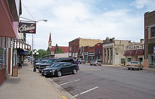
Prairie du Chien is a city in and the county seat of Crawford County, Wisconsin, United States. The population was 5,506 at the 2020 census. Its ZIP Code is 53821.

<span class="mw-page-title-main">Cassville, Wisconsin</span> Village in Wisconsin, United States

Cassville is a village in Grant County, Wisconsin, United States. The population was 777 at the 2020 census. The village is located along the Mississippi River, opposite from the mouth of the Turkey River. It is surrounded by the Town of Cassville.

<span class="mw-page-title-main">Muscoda, Wisconsin</span> Village in Wisconsin, United States

Muscoda is a village in Grant and Iowa counties in the U.S. state of Wisconsin. The population was 1,299 at the 2010 census. Of this, 1,249 were in Grant County and 50 were in Iowa County. The Grant County part of the village is adjacent to the Town of Muscoda and the Iowa County part is adjacent to the Town of Pulaski. Muscoda is the largest village in Grant County.

<span class="mw-page-title-main">Sparta, Wisconsin</span> Place in Wisconsin, United States

Sparta is a city in and the county seat of Monroe County, Wisconsin, United States, along the La Crosse River. The population was 10,025 at the 2020 census.

References

  1. "2020 U.S. Gazetteer Files". United States Census Bureau. Retrieved March 16, 2022.
  2. 1 2 "2020 Census State Redistricting Data". census.gov. United states Census Bureau. Retrieved 12 August 2021.
  3. William Williams (1920) Major William Williams' Journal of a Trip to Iowa in 1849. Annals of Iowa 7(4).
  4. "Reynolds, Joseph "Diamond Jo"". Biographical Dictionary of Iowa. University of Iowa. Retrieved 29 October 2017.
  5. 1 2 Robert M Mc Kay (1997). "Mc Gregors 19 th century refrigerators". Iowa Geology. 22: 20–21.
  6. STORM DAMAGE: A "severe mess" in McGregor, Waterloo, Iowa: KWWL Television, 2017-07-20, retrieved 2017-07-20
  7. "US Gazetteer files: 2010, 2000, and 1990". United States Census Bureau. 2011-02-12. Retrieved 2011-04-23.
  8. "US Gazetteer files 2010". United States Census Bureau. Archived from the original on January 12, 2012. Retrieved 2012-05-11.
  9. "Census of Population and Housing". Census.gov. Retrieved June 4, 2015.
  10. "U.S. Census website". United States Census Bureau . Retrieved 2012-05-11.
  11. "U.S. Census website". United States Census Bureau . Retrieved 2008-01-31.
  12. "MFL Mar Mac" (PDF). Iowa Department of Education . Retrieved 2020-03-27.
  13. "REORGANIZATION & DISSOLUTION ACTIONS SINCE 1965-66" (PDF). Iowa Department of Education. Archived from the original (PDF) on 2019-02-09. Retrieved 2020-03-22.
  14. "Frank Lloyd Wright as a Young Child | Photograph". Wisconsin Historical Society. 2003-12-01. Retrieved 2023-02-03.
  15. Huxtable, Ada Louise (2004-10-31). "'Frank Lloyd Wright'". The New York Times. ISSN   0362-4331 . Retrieved 2023-02-03.