Taylor County, Iowa

Last updated

Taylor County
Bedford, IA Taylor County Courthouse.jpg
Map of Iowa highlighting Taylor County.svg
Location within the U.S. state of Iowa
Iowa in United States.svg
Iowa's location within the U.S.
Coordinates: 40°44′09″N94°41′33″W / 40.735833333333°N 94.6925°W / 40.735833333333; -94.6925
CountryFlag of the United States.svg United States
StateFlag of Iowa.svg  Iowa
Founded1847
Named for Zachary Taylor
Seat Bedford
Largest cityBedford
Area
  Total535 sq mi (1,390 km2)
  Land532 sq mi (1,380 km2)
  Water2.8 sq mi (7 km2)  0.5%
Population
 (2020)
  Total5,896
  Density11/sq mi (4.3/km2)
Time zone UTC−6 (Central)
  Summer (DST) UTC−5 (CDT)
Congressional district 3rd
Website taylorcounty.iowa.gov

Taylor County is a county located in the U.S. state of Iowa. As of the 2020 census, the population was 5,896, [1] making it the fourth-least populous county in Iowa. The county seat is Bedford. [2] The county was formed in 1847 and named after General and President Zachary Taylor. [3]

Contents

Geography

According to the U.S. Census Bureau, the county has a total area of 535 square miles (1,390 km2), of which 532 square miles (1,380 km2) is land and 2.8 square miles (7.3 km2) (0.5%) is water. [4]

A portion of Taylor County at one time was part of Missouri.

Major highways

Adjacent counties

Demographics

Historical population
CensusPop.Note
1850 204
1860 3,5901,659.8%
1870 6,98994.7%
1880 15,635123.7%
1890 16,3844.8%
1900 18,78414.6%
1910 16,312−13.2%
1920 15,514−4.9%
1930 14,859−4.2%
1940 14,258−4.0%
1950 12,420−12.9%
1960 10,288−17.2%
1970 8,790−14.6%
1980 8,353−5.0%
1990 7,114−14.8%
2000 6,958−2.2%
2010 6,317−9.2%
2020 5,896−6.7%
2023 (est.)5,924 [5] 0.5%
U.S. Decennial Census [6]
1790-1960 [7] 1900-1990 [8]
1990-2000 [9] 2010-2018 [10]
Population of Taylor County from US census data TaylorCountyIowaPop2020.png
Population of Taylor County from US census data

2020 census

2022 US Census population pyramid for Taylor County from ACS 5-year estimates TaylorCountyIA2022PopPyr.png
2022 US Census population pyramid for Taylor County from ACS 5-year estimates

The 2020 census recorded a population of 5,896 in the county, with a population density of

Taylor County Racial Composition [11]
RaceNum.Perc.
White (NH)5,30490%
Black or African American (NH)10.02%
Native American (NH)130.22%
Asian (NH)150.25%
Pacific Islander (NH)10.02%
Other/Mixed (NH)1632.76%
Hispanic or Latino 3996.76%

2010 census

The 2010 census recorded a population of 6,317 in the county, with a population density of

Taylor County courthouse TAYLOR COUNTY COURTHOUSE.jpg
Taylor County courthouse

2000 census

At the 2000 census there were 6,958 people, 2,824 households, and 1,911 families in the county. The population density was 13 people per square mile (5.0 people/km2). There were 3,199 housing units at an average density of 6 units per square mile (2.3 units/km2). The racial makeup of the county was 97.71% White, 0.03% Black or African American, 0.10% Native American, 0.30% Asian, 0.06% Pacific Islander, 1.14% from other races, and 0.66% from two or more races. 3.81%. [13] were Hispanic or Latino of any race.

Of the 2,824 households 28.00% had children under the age of 18 living with them, 59.00% were married couples living together, 5.90% had a female householder with no husband present, and 32.30% were non-families. 27.80% of households were one person and 16.10% were one person aged 65 or older. The average household size was 2.40 and the average family size was 2.94.

The age distribution was 23.90% under the age of 18, 7.50% from 18 to 24, 23.40% from 25 to 44, 22.80% from 45 to 64, and 22.40% 65 or older. The median age was 42 years. For every 100 females there were 94.10 males. For every 100 females age 18 and over, there were 92.00 males.

The median household income was $31,297 and the median family income was $37,194. Males had a median income of $26,631 versus $19,162 for females. The per capita income for the county was $15,082. About 8.50% of families and 12.10% of the population were below the poverty line, including 13.10% of those under age 18 and 15.20% of those age 65 or over.

Communities

Cities

Census-designated place

Townships

Population ranking

The population ranking of the following table is based on the 2020 census of Taylor County. [1]

county seat

RankCity/Town/etc.Municipal typePopulation (2020 Census)
1 Bedford City1,508
2 Lenox (partially in Adams County )City1,339 (1,339 total)
3 New Market City385
4 Clearfield (partially in Ringgold County )City272 (278 total)
5 Gravity City154
6 Blockton City125
7 Sharpsburg City72
8 Conway City17
9 Athelstan CDP6

Politics

United States presidential election results for Taylor County, Iowa [14]
Year Republican Democratic Third party
No.%No.%No.%
2020 2,46375.81%74622.96%401.23%
2016 2,11169.69%75825.02%1605.28%
2012 1,68356.19%1,26242.14%501.67%
2008 1,60753.11%1,34744.51%722.38%
2004 1,90859.81%1,25239.25%300.94%
2000 1,77057.17%1,24740.28%792.55%
1996 1,41943.32%1,45844.51%39912.18%
1992 1,20033.79%1,43040.27%92125.94%
1988 1,64749.43%1,67150.15%140.42%
1984 2,49662.06%1,49937.27%270.67%
1980 2,71564.44%1,22629.10%2726.46%
1976 2,05950.79%1,94748.03%481.18%
1972 3,04270.16%1,24728.76%471.08%
1968 2,76559.64%1,50132.38%3707.98%
1964 2,16243.75%2,78056.25%00.00%
1960 3,45261.85%2,12638.09%30.05%
1956 3,53359.10%2,43640.75%90.15%
1952 4,60871.74%1,78427.78%310.48%
1948 3,24456.93%2,40242.16%520.91%
1944 3,80461.35%2,37638.32%200.32%
1940 4,42059.56%2,97640.10%250.34%
1936 4,14554.94%3,33744.23%630.83%
1932 2,67045.07%3,15953.33%951.60%
1928 4,70068.68%2,07430.31%691.01%
1924 4,25460.95%1,13816.30%1,58822.75%
1920 4,99772.41%1,75725.46%1472.13%
1916 2,21954.70%1,77543.75%631.55%
1912 1,36435.40%1,37235.61%1,11728.99%
1908 2,46058.77%1,58537.86%1413.37%
1904 2,65065.90%1,06026.36%3117.73%
1900 2,79257.25%1,98440.68%1012.07%
1896 2,46851.55%2,29347.89%270.56%

See also

Related Research Articles

<span class="mw-page-title-main">Adams County, Iowa</span> County in Iowa, United States

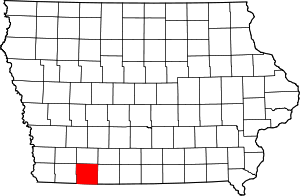
Adams County is a county in the U.S. state of Iowa. As of the 2020 census, the population was 3,704, making it Iowa's least-populous county. Its county seat is Corning.

<span class="mw-page-title-main">Worth County, Missouri</span> County in Missouri, United States

Worth County is a county located in the northwestern portion of the U.S. state of Missouri. As of the 2020 census, the population was 1,973. It is the smallest county in the state in population and, excluding the independent city of St. Louis, the smallest in total area. Its county seat is Grant City. The county was organized February 8, 1861, and named for General William J. Worth, who served in the Mexican–American War. Worth County is also the youngest county in the state.

<span class="mw-page-title-main">Ringgold County, Iowa</span> County in Iowa, United States

Ringgold County is a county located in the U.S. state of Iowa. As of the 2020 census, the population was 4,663, making it the Iowa county with the second-smallest population. The county seat is Mount Ayr. The county is named after Maj. Samuel Ringgold, a hero of the Battle of Palo Alto fought in May 1846, during the Mexican–American War. It is one of the 26 Iowa counties with a name that is unique across the nation.

<span class="mw-page-title-main">Page County, Iowa</span> County in Iowa, United States

Page County is a county located in the U.S. state of Iowa. As of the 2020 census, the population was 15,211. The county seat is Clarinda. The county is named in honor of Captain John Page of the 4th U.S. Infantry, who was mortally wounded in the Battle of Palo Alto.

<span class="mw-page-title-main">Hamilton County, Iowa</span> County in Iowa, United States

Hamilton County is a county located in the U.S. state of Iowa. As of the 2020 census, the population was 15,039. The county seat is Webster City. The county was named to honor William W. Hamilton, a President of the Iowa State Senate.

<span class="mw-page-title-main">Emmet County, Iowa</span> County in Iowa, United States

Emmet County is a county located in the U.S. state of Iowa. As of the 2020 census, the population was 9,388. The county seat is Estherville.

<span class="mw-page-title-main">Audubon County, Iowa</span> County in Iowa, United States

Audubon County is a county in the U.S. state of Iowa. As of the 2020 census, the population was 5,674, making it Iowa's third-least populous county. Its county seat is Audubon. The county was named after John James Audubon, the naturalist and artist.

<span class="mw-page-title-main">Adair County, Iowa</span> County in Iowa, United States

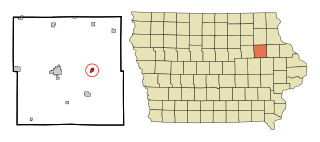
Adair County is a county in the U.S. state of Iowa. As of the 2020 census, the population was 7,496. Its county seat is Greenfield.

<span class="mw-page-title-main">Bridgewater, Iowa</span> City in Iowa, United States

Bridgewater is a city in Jackson Township, Adair County, Iowa, United States. The population was 148 at the time of the 2020 census. Bridgewater was founded in 1885.

<span class="mw-page-title-main">Fontanelle, Iowa</span> City in Iowa, United States

Fontanelle is a city in Summerset Township, Adair County, Iowa, United States. The population was 676 at the time of the 2020 census.

<span class="mw-page-title-main">Nodaway, Iowa</span> City in Iowa, United States

Nodaway is a city in Nodaway Township, Adams County, Iowa, United States. The population was 74 at the time of the 2020 census. Nodaway was incorporated in 1900.

<span class="mw-page-title-main">Winthrop, Iowa</span> City in Iowa, United States

Winthrop is a city in Buchanan County, Iowa, United States. The population was 823 at the time of the 2020 census.

<span class="mw-page-title-main">Lake City, Iowa</span> City in Iowa, United States

Lake City is a city in Calhoun County, Iowa, United States, founded in 1856. The population was 1,731 at the time of the 2020 census. The sign coming into town proudly proclaims that Lake City has "Everything but a Lake."

<span class="mw-page-title-main">Braddyville, Iowa</span> City in Iowa, United States

Braddyville is a city in Page County, Iowa, United States. The population was 147 at the 2020 census.

<span class="mw-page-title-main">Bedford, Iowa</span> City in Iowa, United States

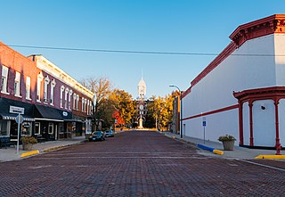
Bedford is a city in Taylor County, Iowa, United States. The population was 1,508 at the 2020 census. It is the county seat of Taylor County. Lake of Three Fires State Park is located several miles northeast of Bedford.

<span class="mw-page-title-main">Blockton, Iowa</span> City in Iowa, United States

Blockton is a city in Taylor County, Iowa, United States. The population was 125 at the 2020 census.

<span class="mw-page-title-main">Graham, Missouri</span> City in Missouri, United States

Graham is a city in Nodaway County, Missouri, United States. The population was 171 at the 2010 census.

<span class="mw-page-title-main">Skidmore, Missouri</span> City in Missouri, United States

Skidmore is a city in western Nodaway County, Missouri, United States. The population was 245 at the 2020 Census. The small farming community is known for the unsolved extrajudicial killing of Ken Rex McElroy, the murders of Wendy Gillenwater and Bobbie Jo Stinnett, and the disappearance of Branson Perry. Skidmore also has a yearly "Punkin' Show."

<span class="mw-page-title-main">Kingston Springs, Tennessee</span> Town in Tennessee, United States

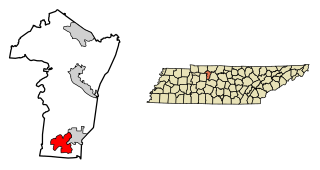
Kingston Springs is a town in Cheatham County, Tennessee, United States. As of the 2020 census, the population was 2,824.

<span class="mw-page-title-main">Clearfield, Iowa</span> City in Iowa, United States

Clearfield is a city in Taylor and Ringgold counties in the U.S. state of Iowa. The population was 278 at the time of the 2020 census.

References

  1. 1 2 3 "2020 Census State Redistricting Data". census.gov. United states Census Bureau. Retrieved August 12, 2021.
  2. "Find a County". National Association of Counties. Retrieved June 7, 2011.
  3. "Taylor County". www.iowacounties.org. Archived from the original on April 25, 2007.
  4. "US Gazetteer files: 2010, 2000, and 1990". United States Census Bureau. February 12, 2011. Retrieved April 23, 2011.
  5. "Annual Estimates of the Resident Population for Counties: April 1, 2020 to July 1, 2023". United States Census Bureau. Retrieved April 2, 2024.
  6. "U.S. Decennial Census". United States Census Bureau. Retrieved July 20, 2014.
  7. "Historical Census Browser". University of Virginia Library. Retrieved July 20, 2014.
  8. "Population of Counties by Decennial Census: 1900 to 1990". United States Census Bureau. Retrieved July 20, 2014.
  9. "Census 2000 PHC-T-4. Ranking Tables for Counties: 1990 and 2000" (PDF). United States Census Bureau. Archived (PDF) from the original on March 27, 2010. Retrieved July 20, 2014.
  10. "State & County QuickFacts". United States Census Bureau. Archived from the original on June 7, 2011. Retrieved July 20, 2014.
  11. "P2 HISPANIC OR LATINO, AND NOT HISPANIC OR LATINO BY RACE – 2020: DEC Redistricting Data (PL 94-171) – Taylor County, Iowa".
  12. "Population & Housing Occupancy Status 2010" (PDF). United States Census Bureau American FactFinder. Archived (PDF) from the original on October 16, 2020. Retrieved August 15, 2022.
  13. "U.S. Census website". United States Census Bureau . Retrieved January 31, 2008.
  14. Leip, David. "Dave Leip's Atlas of U.S. Presidential Elections". uselectionatlas.org. Retrieved April 28, 2018.

40°44′09″N94°41′33″W / 40.73583°N 94.69250°W / 40.73583; -94.69250