Lenox, Iowa | |
---|---|
Coordinates: 40°53′0″N94°33′30″W / 40.88333°N 94.55833°W | |
Country | United States |
State | Iowa |
Counties | Taylor & Adams |
Area | |
• Total | 1.98 sq mi (5.13 km2) |
• Land | 1.90 sq mi (4.92 km2) |
• Water | 0.08 sq mi (0.21 km2) |
Elevation | 1,303 ft (397 m) |
Population (2020) | |
• Total | 1,339 |
• Density | 704.74/sq mi (272.08/km2) |
Time zone | UTC-6 (Central (CST)) |
• Summer (DST) | UTC-5 (CDT) |
ZIP code | 50851 |
Area code | 641 |
FIPS code | 19-44490 |
GNIS feature ID | 2395678 [2] |
Lenox is a city in Taylor and Adams counties in the U.S. state of Iowa. The population was 1,339 at the time of the 2020 census. [3]
Lenox got its start in the year 1871, following construction of the Chicago, Burlington and Quincy Railroad through the territory. [4]
According to the United States Census Bureau, the city has a total area of 2.06 square miles (5.34 km2), of which 1.98 square miles (5.13 km2) is land and 0.08 square miles (0.21 km2) is water. [5]
Year | Pop. | ±% |
---|---|---|
1880 | 615 | — |
1890 | 706 | +14.8% |
1900 | 1,014 | +43.6% |
1910 | 1,274 | +25.6% |
1920 | 1,197 | −6.0% |
1930 | 1,171 | −2.2% |
1940 | 1,220 | +4.2% |
1950 | 1,171 | −4.0% |
1960 | 1,178 | +0.6% |
1970 | 1,215 | +3.1% |
1980 | 1,338 | +10.1% |
1990 | 1,303 | −2.6% |
2000 | 1,401 | +7.5% |
2010 | 1,407 | +0.4% |
2020 | 1,339 | −4.8% |
Source: "U.S. Census website". United States Census Bureau . Retrieved 2020-03-29. and Iowa Data Center Source: |
As of the census [7] of 2010, there were 1,407 people, 609 households, and 344 families living in the city. The population density was 710.6 inhabitants per square mile (274.4/km2). There were 664 housing units at an average density of 335.4 per square mile (129.5/km2). The racial makeup of the city was 91.3% White, 0.4% African American, 0.4% Asian, 7.0% from other races, and 0.9% from two or more races. Hispanic or Latino of any race were 19.8% of the population.
There were 609 households, of which 26.4% had children under the age of 18 living with them, 43.3% were married couples living together, 8.4% had a female householder with no husband present, 4.8% had a male householder with no wife present, and 43.5% were non-families. 36.8% of all households were made up of individuals, and 20.5% had someone living alone who was 65 years of age or older. The average household size was 2.26 and the average family size was 3.01.
The median age in the city was 42 years. 24% of residents were under the age of 18; 7.4% were between the ages of 18 and 24; 20.9% were from 25 to 44; 25.7% were from 45 to 64; and 22% were 65 years of age or older. The gender makeup of the city was 48.8% male and 51.2% female.
As of the census [8] of 2000, there were 1,402 people, 559 households, and 335 families living in the city. The population density was 709.0 inhabitants per square mile (273.7/km2). There were 623 housing units at an average density of 315.3 per square mile (121.7/km2). The racial makeup of the city was 94.79% White, 0.71% Asian, 3.28% from other races, and 1.21% from two or more races. Hispanic or Latino of any race were 14.28% of the population.
There were 559 households, out of which 24.3% had children under the age of 18 living with them, 51.9% were married couples living together, 4.8% had a female householder with no husband present, and 39.9% were non-families. 34.3% of all households were made up of individuals, and 18.4% had someone living alone who was 65 years of age or older. The average household size was 2.33 and the average family size was 3.02.
Age spread: 22.1% under the age of 18, 8.8% from 18 to 24, 21.8% from 25 to 44, 23.1% from 45 to 64, and 24.1% who were 65 years of age or older. The median age was 43 years. For every 100 females there were 93.2 males. For every 100 females age 18 and over, there were 89.4 males.
The median income for a household in the city was $29,958, and the median income for a family was $37,917. Males had a median income of $26,938 versus $18,125 for females. The per capita income for the city was $14,299. About 5.2% of families and 14.2% of the population were below the poverty line, including 11.4% of those under age 18 and 22.8% of those age 65 or over.
Lenox is a part of the Lenox Community School District. [9]
Lenox is home to the Lenox Rodeo, held annually by the Lenox Stock and Saddle Club.
Lenox High School won the Class 1A Iowa State Baseball Championship in 2006, [10] and the Iowa Eight-Player Class Football State Championship in 2008. [11] In 2009 and 2010, Lenox was runner-up in the Iowa Eight-Player Class Football State Championship to Armstrong-Ringsted.
Lenox was used as a shooting location for the film The Crazies (2010).
Fairbank is a city in Buchanan and Fayette counties in the U.S. state of Iowa. The population was 1,111 at the time of the 2020 census.
Allison is a city in, and the county seat of, Butler County, Iowa, United States. The population was 966 at the 2020 census. Allison is home to the Butler County Fair. The city was named for U.S. Senator William B. Allison in 1881.
Pulaski is a city in Davis County, Iowa, United States. The population was 264 at the time of the 2020 census.
Hopkinton is a city in Delaware County, Iowa, United States. The population was 622 at the time of the 2020 census.
Orleans is a city in Dickinson County, Iowa, United States. The population was 521 at the time of the 2020 census. Orleans is part of the Iowa Great Lakes region, located along Spirit Lake. Numerous state parks are located within a few miles of the town, including Marble Beach and Mini-Wakan.
Little Sioux is a city in Harrison County, Iowa, United States. The population was 166 at the time of the 2020 census. The city is most known for Little Sioux Scout Ranch of the Boy Scouts of America.
Hills is a city in Johnson County, Iowa, United States. It is part of the Iowa City, Iowa Metropolitan Statistical Area. The population was 863 at the time of the 2020 census. It is part of the Iowa City Community School District.
Columbus City is a city in western Louisa County, Iowa, United States. The population was 392 at the 2020 census. It is part of the Muscatine Micropolitan Statistical Area.
Wapello is a city in and the county seat of Louisa County, Iowa, United States. The population was 2,084 at the time of the 2020 census.
Derby is a city in Lucas County, Iowa, United States. The population was 90 at the time of the 2020 census.
Emerson is a city in Mills County, Iowa, United States. The population was 403 at the time of the 2020 census.
Runnells is a city in the southeastern corner of Polk County, Iowa, United States. The population was 457 at the time of the 2020 census. It is part of the Des Moines–West Des Moines Metropolitan Statistical Area. Runnells has its own Post Office, located at 112 Brown Street.
Diagonal is a city in northwest Ringgold County, Iowa, United States. The population was 344 at the time of the 2020 census.
Dixon is a city in Scott County, Iowa, United States. The population was 202 at the time of the 2020 census.
Donahue is a city in Scott County, Iowa, United States. The population was 335 at the 2020 census. The city has a mayor-council form of government.
Cambridge is a city in Story County, Iowa, United States. The population was 827 at the 2020 census. It is part of the Ames, Iowa Metropolitan Statistical Area, which is a part of the larger Ames-Boone, Iowa Combined Statistical Area.
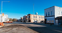
Bedford is a city in Taylor County, Iowa, United States. The population was 1,508 at the 2020 census. It is the county seat of Taylor County. Lake of Three Fires State Park is located a few miles northeast of Bedford.
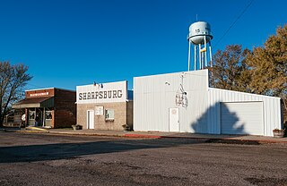
Sharpsburg is a city in Taylor County, Iowa, United States. The population was 72 at the time of the 2020 census.
Sloan is a city in Woodbury County, Iowa, United States. It is part of the Sioux City, IA–NE–SD Metropolitan Statistical Area. The population was 1,042 at the time of the 2020 census.
Clearfield is a city in Taylor and Ringgold counties in the U.S. state of Iowa. The population was 278 at the time of the 2020 census.