Calhoun County, Iowa

Last updated

Calhoun County
Calhoun County IA Courthouse.jpg
LakeCityIA CentralSchool.jpg
LakeCityIA FormerCarnegieLibrary.jpg
Grain elevators of Somers, Iowa rise from a field at sunset.jpg
Clockwise from top: Calhoun County Courthouse in Rockwell City, the former Lake City Public Library, a grain elevator in the small town of Somers rises from a field at sunset, and the historic Central School in Lake City
Map of Iowa highlighting Calhoun County.svg
Location within the U.S. state of Iowa
Iowa in United States.svg
Iowa's location within the U.S.
Coordinates: 42°23′10″N94°38′50″W / 42.386111111111°N 94.647222222222°W / 42.386111111111; -94.647222222222
CountryFlag of the United States.svg United States
StateFlag of Iowa.svg  Iowa
Founded1855
Named for John C. Calhoun
Seat Rockwell City
Largest cityRockwell City
Area
  Total572 sq mi (1,480 km2)
  Land570 sq mi (1,500 km2)
  Water2.1 sq mi (5 km2)  0.4%
Population
 (2020)
  Total9,927
  Density17/sq mi (6.7/km2)
Time zone UTC−6 (Central)
  Summer (DST) UTC−5 (CDT)
Congressional district 4th
Website www.calhouncounty.iowa.gov

Calhoun County is a county located in the U.S. state of Iowa. As of the 2020 census, the population was 9,927. [1] Its county seat is Rockwell City. [2]

Contents

History

Calhoun County was formed on January 15, 1851, from open land originally named Fox County. It was renamed in 1853 after the seventh US vice president secessionist John C. Calhoun. When the tracks of the Illinois Central Railroad were laid through the county in 1870, the county seat was moved from Lake City to Rockwell City. The first train reached Rockwell City on August 7, 1882, and the population count doubled in the same year. The first courthouse, built of wood, burned to the ground in 1884 and the county government moved into a nearby hotel. In 1913, the current courthouse was built.

On July 6, 1893, Pomeroy was struck by a tornado that measured F5 on the Fujita scale. With a damage path 500 yards (460 m) wide and 55 miles (89 km) long, the tornado destroyed about 80% of the homes in Pomeroy. The tornado killed 71 people and injured 200.

Geography

According to the U.S. Census Bureau, the county has a total area of 572 square miles (1,480 km2), of which 570 square miles (1,500 km2) is land and 2.1 square miles (5.4 km2) (0.4%) is water. [3]

Ecology

Calhoun County is located entirely within the Des Moines Lobe of the Western Corn Belt Plains ecoregion, as defined by the United States Environmental Protection Agency (EPA). One of the flattest regions in Iowa, the Des Moines Lobe ecoregion is a distinctive area naturally defined by Wisconsin glaciation but modified by humans for extensive agriculture. In general, the land is level to gently rolling with some areas of relief defined by glacial features like moraines, hummocky knobs, and kettles, and outwash deposits. The lobe does not have any loess deposits like the Loess Hills to the west.

The stream network is poorly developed and widely spaced, with major rivers carving valleys that are relatively deep and steep-sided. Almost all of the natural lakes of Iowa are found in the northern part of this region (the Iowa Great Lakes). Most of the region has been converted from wet prairie to agricultural use with substantial surface water drainage. Only a small fraction of the wetlands remain, and many natural lakes have been drained as a result of agricultural drainage projects via drainage tiles or ditches. [4]

Major highways

Adjacent counties

Demographics

Historical population
CensusPop.Note
1860 147
1870 1,602989.8%
1880 5,595249.3%
1890 13,107134.3%
1900 18,56941.7%
1910 17,090−8.0%
1920 17,7834.1%
1930 17,605−1.0%
1940 17,584−0.1%
1950 16,925−3.7%
1960 15,923−5.9%
1970 14,287−10.3%
1980 13,542−5.2%
1990 11,508−15.0%
2000 11,115−3.4%
2010 9,670−13.0%
2020 9,9272.7%
2023 (est.)9,763 [5] −1.7%
U.S. Decennial Census [6]
1790-1960 [7] 1900-1990 [8]
1990-2000 [9] 2010-2018 [10]
Population of Calhoun County from US census data CalhounCountyIowaPop2020.png
Population of Calhoun County from US census data

2020 census

2022 US Census population pyramid for Calhoun County from ACS 5-year estimates CalhounCountyIA2022PopPyr.png
2022 US Census population pyramid for Calhoun County from ACS 5-year estimates

The 2020 census recorded a population of 9,927 in the county, with a population density of

2010 census

The 2010 census recorded a population of 9,670 in the county, with a population density of

2000 census

As of the census [12] of 2000, there were 11,115 people, 4,513 households, and 3,014 families residing in the county. The population density was 20 people per square mile (7.7 people/km2). There were 5,219 housing units at an average density of 9 units per square mile (3.5 units/km2). The racial makeup of the county was 98.06% White, 0.69% Black or African American, 0.20% Native American, 0.18% Asian, 0.01% Pacific Islander, 0.34% from other races, and 0.52% from two or more races. 0.90% of the population were Hispanic or Latino of any race.

There were 4,513 households, out of which 27.80% had children under the age of 18 living with them, 57.90% were married couples living together, 6.60% had a female householder with no husband present, and 33.20% were non-families. 30.50% of all households were made up of individuals, and 17.80% had someone living alone who was 65 years of age or older. The average household size was 2.31 and the average family size was 2.87.

In the county, the population was spread out, with 23.10% under the age of 18, 6.40% from 18 to 24, 24.80% from 25 to 44, 23.70% from 45 to 64, and 22.10% who were 65 years of age or older. The median age was 42 years. For every 100 females there were 98.10 males. For every 100 females age 18 and over, there were 97.60 males.

The median income for a household in the county was $33,286, and the median income for a family was $41,583. Males had a median income of $28,787 versus $20,095 for females. The per capita income for the county was $17,498. 10.10% of the population and 7.10% of families were below the poverty line. Out of the total population, 13.50% of those under the age of 18 and 8.50% of those 65 and older were living below the poverty line.

Communities

Cities

Unincorporated communities

Townships

Calhoun County is divided into sixteen townships:

Population ranking

The population ranking of the following table is based on the 2020 census of Calhoun County. [1]

county seat

RankCity/Town/etc.Municipal typePopulation (2020 Census)
1 Rockwell City City2,240
2 Lake City City1,731
3 Manson City1,709
4 Pomeroy City526
5 Farnhamville (partially in Webster County )City383
6 Lohrville City381
7 Twin Lakes CDP316
8 Lytton (mostly in Sac County )City40 (282 total)
9 Somers City128
10 Knierim City53
11 Rinard City38
12 Jolley City28
13 Yetter City19

Politics

Politically, Calhoun County has favored the Republicans since 1896, usually only voting Democratic when the party won national victories. It first voted for the Democrats in 1932 when Franklin D. Roosevelt won in a landslide victory against Herbert Hoover. In 2000, Calhoun County voted for George W. Bush and has voted for the Republicans ever since. In 2016 Donald Trump won 67.2% percent of the vote in Calhoun County, the highest vote share since Dwight D. Eisenhower's victory in 1952. In 2020, Trump increased it to 70.2%, the highest percentage of any party in the county since Warren G. Harding a century earlier.

United States presidential election results for Calhoun County, Iowa [13]
Year Republican Democratic Third party
No.%No.%No.%
2020 3,68970.16%1,47027.96%991.88%
2016 3,46867.22%1,39827.10%2935.68%
2012 2,89155.28%2,23842.79%1011.93%
2008 2,74152.76%2,34145.06%1132.18%
2004 3,25558.73%2,24340.47%440.79%
2000 2,77655.07%2,13242.29%1332.64%
1996 2,07743.46%2,19345.89%50910.65%
1992 2,16941.13%2,14040.58%96518.30%
1988 2,47444.94%2,99054.31%410.74%
1984 3,31156.14%2,54143.08%460.78%
1980 3,63357.41%2,15033.98%5458.61%
1976 3,21551.03%3,00147.63%841.33%
1972 3,82160.00%2,44638.41%1011.59%
1968 3,71557.53%2,36136.56%3825.92%
1964 2,42235.42%4,40764.46%80.12%
1960 4,48558.90%3,12341.01%70.09%
1956 4,40957.49%2,97238.75%2883.76%
1952 5,39167.68%2,41130.27%1642.06%
1948 3,08348.19%3,16449.45%1512.36%
1944 3,37548.59%3,54451.02%270.39%
1940 3,79246.46%4,34453.23%250.31%
1936 3,02739.32%4,54459.02%1281.66%
1932 2,40434.46%4,36862.61%2052.94%
1928 4,13660.24%2,68139.05%490.71%
1924 3,52953.21%71410.77%2,38936.02%
1920 5,27776.95%1,47921.57%1021.49%
1916 2,27658.34%1,51538.84%1102.82%
1912 96326.61%1,18232.66%1,47440.73%
1908 2,35363.03%1,15230.86%2286.11%
1904 2,47967.44%87023.67%3278.90%
1900 2,97369.61%1,22428.66%741.73%
1896 2,69867.25%1,28031.90%340.85%

See also

Related Research Articles

<span class="mw-page-title-main">Calhoun County, Alabama</span> County in Alabama, United States

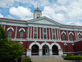
Calhoun County is a county in the east central part of the U.S. state of Alabama. As of the 2020 census, the population was 116,441. Its county seat is Anniston. It is named in honor of John C. Calhoun, a US Senator from South Carolina.

<span class="mw-page-title-main">Washington County, Nebraska</span> County in Nebraska, United States

Washington County is a county in the U.S. state of Nebraska. As of the 2020 United States Census, the population was 20,865. Its county seat is Blair.

<span class="mw-page-title-main">Saunders County, Nebraska</span> County in Nebraska, United States

Saunders County is a county in the U.S. state of Nebraska. As of the 2020 United States Census, the population was 22,278. Its county seat is Wahoo.

<span class="mw-page-title-main">Sac County, Iowa</span> County in Iowa, United States

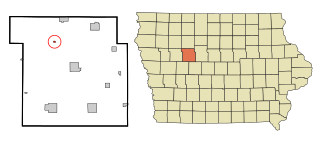
Sac County is a county located in the U.S. state of Iowa. As of the 2020 census, the population was 9,814. The county seat is Sac City. Both were named for the Sauk people, a local American Indian tribe.

<span class="mw-page-title-main">Pocahontas County, Iowa</span> County in Iowa, United States

Pocahontas County is a county located in Iowa, United States. As of the 2020 census the population was 7,078, making it the state's ninth-least populous county. The county seat is Pocahontas. The county was formed in 1851.

<span class="mw-page-title-main">Lyon County, Iowa</span> County in Iowa, United States

Lyon County is the most northwesterly county of the U.S. state of Iowa. As of the 2020 census, the population was 11,934. The county seat is Rock Rapids.

<span class="mw-page-title-main">Lucas County, Iowa</span> County in Iowa, United States

Lucas County is a county located in the U.S. state of Iowa. As of the 2020 census, the population was 8,634. The county seat is Chariton. The county was formed in 1846 and was named for Robert Lucas, a Governor of the Territory.

<span class="mw-page-title-main">Humboldt County, Iowa</span> County in Iowa, United States

Humboldt County is a county in the U.S. state of Iowa. As of the 2020 census, the population was 9,597. The county seat is Dakota City. The county was created in 1857 and named in honor of Alexander von Humboldt.

<span class="mw-page-title-main">Cerro Gordo County, Iowa</span> County in Iowa, United States

Cerro Gordo County is a county located in the U.S. state of Iowa. As of the 2020 census, the population was 43,127. Its county seat is Mason City. The county is named for the Battle of Cerro Gordo, which took place during the Mexican–American War.

<span class="mw-page-title-main">Buena Vista County, Iowa</span> County in Iowa, United States

Buena Vista County is a county located in the U.S. state of Iowa. As of the 2020 census, the population was 20,823. Its county seat is Storm Lake. The county is named for the final victory of Field General Zachary Taylor in the Mexican–American War.

<span class="mw-page-title-main">Jolley, Iowa</span> City in Iowa, United States

Jolley is a city in Calhoun County, Iowa, United States. The population was 28 at the time of the 2020 census.

<span class="mw-page-title-main">Lake City, Iowa</span> City in Iowa, United States

Lake City is a city in Calhoun County, Iowa, United States, founded in 1856. The population was 1,731 at the time of the 2020 census. The sign coming into town proudly proclaims that Lake City has "Everything but a Lake."

<span class="mw-page-title-main">Lytton, Iowa</span> City in Iowa, United States

Lytton is a city in Sac County and has grown into Calhoun County in the U.S. state of Iowa. The population was 282 at the time of the 2020 census.

<span class="mw-page-title-main">Pomeroy, Iowa</span> City in Iowa, United States

Pomeroy is a city in Calhoun County, Iowa, United States. The population was 526 at the time of the 2020 census.

<span class="mw-page-title-main">Rinard, Iowa</span> City in Iowa, United States

Rinard is a city in Calhoun County, Iowa, United States. The population was 38 at the time of the 2020 census.

<span class="mw-page-title-main">Rockwell City, Iowa</span> City in Iowa, United States

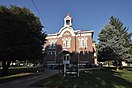
Rockwell City is a city in Calhoun County, Iowa, United States. The population was 2,240 in 2020. It is the county seat of Calhoun County.

<span class="mw-page-title-main">Lanesboro, Iowa</span> City in Iowa, United States

Lanesboro is a city in Carroll County, Iowa, United States. The population was 119 at the time of the 2020 census.

<span class="mw-page-title-main">Spirit Lake, Iowa</span> City in Iowa, United States

Spirit Lake is a city in Dickinson County, Iowa, United States. The population was 5,439 at the 2020 census. It is the county seat of Dickinson County.

<span class="mw-page-title-main">Northboro, Iowa</span> City in Iowa, United States

Northboro is a city in Page County, Iowa, United States. The population was 52 at the time of the 2020 census.

<span class="mw-page-title-main">Creston, Iowa</span> City in Iowa, United States

Creston is a city in and the county seat of Union County, Iowa. The population was 7,536 at the time of the 2020 Census.

References

  1. 1 2 3 "2020 Census State Redistricting Data". census.gov. United states Census Bureau. Retrieved August 12, 2021.
  2. "Find a County". National Association of Counties. Archived from the original on May 31, 2011. Retrieved June 7, 2011.
  3. "US Gazetteer files: 2010, 2000, and 1990". United States Census Bureau. February 12, 2011. Retrieved April 23, 2011.
  4. PD-icon.svg This article incorporates public domain material from Chapman, S.S., Omernik, J.M., Griffith, G.E.; et al. Ecoregions of Iowa and Missouri (PDF). United States Geological Survey. Archived (PDF) from the original on March 8, 2022.{{citation}}: CS1 maint: multiple names: authors list (link) (color poster with map, descriptive text, summary tables, and photographs).
  5. "Annual Estimates of the Resident Population for Counties: April 1, 2020 to July 1, 2023". United States Census Bureau. Retrieved April 2, 2024.
  6. "U.S. Decennial Census". United States Census Bureau. Retrieved July 14, 2014.
  7. "Historical Census Browser". University of Virginia Library. Retrieved July 14, 2014.
  8. "Population of Counties by Decennial Census: 1900 to 1990". United States Census Bureau. Retrieved July 14, 2014.
  9. "Census 2000 PHC-T-4. Ranking Tables for Counties: 1990 and 2000" (PDF). United States Census Bureau. Archived (PDF) from the original on March 27, 2010. Retrieved July 14, 2014.
  10. "State & County QuickFacts". United States Census Bureau. Archived from the original on June 7, 2011. Retrieved July 14, 2014.
  11. "Population and Housing Occupancy Status: 2010 - State County". United States Census Bureau American FactFinder. Archived from the original on September 29, 2015. Retrieved March 8, 2011.[ dead link ]
  12. "U.S. Census website". United States Census Bureau . Retrieved January 31, 2008.
  13. Leip, David. "Dave Leip's Atlas of U.S. Presidential Elections". uselectionatlas.org. Retrieved April 25, 2018.

42°23′10″N94°38′50″W / 42.38611°N 94.64722°W / 42.38611; -94.64722