Yetter, Iowa

Last updated
Yetter, Iowa
Yetter, IA.jpg
Motto: 
Everything's Better in Yetter
Calhoun County Iowa Incorporated and Unincorporated areas Yetter Highlighted.svg
Location of Yetter, Iowa
Coordinates: 42°18′59″N94°50′38″W / 42.31639°N 94.84389°W / 42.31639; -94.84389 Coordinates: 42°18′59″N94°50′38″W / 42.31639°N 94.84389°W / 42.31639; -94.84389
Country Flag of the United States.svg  United States
State Flag of Iowa.svg  Iowa
County Calhoun
Area
[1]
  Total0.13 sq mi (0.33 km2)
  Land0.13 sq mi (0.33 km2)
  Water0.00 sq mi (0.00 km2)
Elevation
1,230 ft (375 m)
Population
 (2020)
  Total19
  Density148.44/sq mi (57.38/km2)
Time zone UTC-6 (Central (CST))
  Summer (DST) UTC-5 (CDT)
ZIP code
51433
Area code 712
FIPS code 19-87375
GNIS feature ID0463245

Yetter is a city in Calhoun County, Iowa, United States. The population was 19 at the time of the 2020 census. [2]

Contents

History

Yetter was platted in 1899. It was named for its founder, L. M. Yetter. [3]

Geography

Yetter is located at 42°18′59″N94°50′38″W / 42.31639°N 94.84389°W / 42.31639; -94.84389 (42.316473, -94.843820). [4]

According to the United States Census Bureau, the city has a total area of 0.13 square miles (0.34 km2), all land. [5]

Demographics

Historical populations
YearPop.±%
1910 107    
1920 125+16.8%
1930 114−8.8%
1940 135+18.4%
1950 121−10.4%
1960 85−29.8%
1970 52−38.8%
1980 52+0.0%
1990 49−5.8%
2000 36−26.5%
2010 34−5.6%
2020 19−44.1%
Source: "U.S. Census website". United States Census Bureau . Retrieved 2020-03-29. and Iowa Data Center
Source:
U.S. Decennial Census [6] [2]

2020 census

As of the 2020 Census, [7] the total population was 19 people. The population density was 146 people per square mile, spread over 0.13 miles. Of those 19 people, the median age was 55.3 years, with 22% of the town's population under the age of 18, 58.5% between the ages of 18 and 64, and 19.5% of the population over the age of 65. There were a total of 19 households, with an average of 1 person per household.

54% of the town's population was female, with 46% of the population male. The racial makeup of the town was 100% White, of those 19 people 4.9% were of English descent, 65.9% German, and 36.6% Irish.

The average income per capita of Yetter was $19,271, which is far lower than the state average, and the median household income was $19,271, almost 66% lower than the rest of the state. 43.9% of the town’s population lives under the poverty line, which is far lower than the rest of the state.

42.1% of the population of the town is identified as currently married.

88% of the Yetter population has received a high school degree, which is 4.5 percentage points lower than the rest of the state. The town falls far below the state average of bachelor’s degrees with only 4% of the town’s population having received a bachelor’s degree. [8]

15.6% of the town's population were veterans.

2010 census

As of the census [9] of 2010, there were 34 people, 16 households, and 9 families living in the city. The population density was 261.5 inhabitants per square mile (101.0/km2). There were 20 housing units at an average density of 153.8 per square mile (59.4/km2). The racial makeup of the city was 97.1% White and 2.9% Asian.

There were 16 households, of which 25.0% had children under the age of 18 living with them, 43.8% were married couples living together, 12.5% had a male householder with no wife present, and 43.8% were non-families. 43.8% of all households were made up of individuals, and 25.1% had someone living alone who was 65 years of age or older. The average household size was 2.13 and the average family size was 3.00.

The median age in the city was 49.5 years. 20.6% of residents were under the age of 18; 2.8% were between the ages of 18 and 24; 20.5% were from 25 to 44; 38.2% were from 45 to 64; and 17.6% were 65 years of age or older. The gender makeup of the city was 61.8% male and 38.2% female.

2000 census

As of the census [10] of 2000, there were 36 people, 18 households, and 9 families living in the city. The population density was 292.7 inhabitants per square mile (113.0/km2). There were 20 housing units at an average density of 162.6 per square mile (62.8/km2). The racial makeup of the city was 100.00% White.

There were 18 households, out of which 22.2% had children under the age of 18 living with them, 33.3% were married couples living together, 11.1% had a female householder with no husband present, and 50.0% were non-families. 44.4% of all households were made up of individuals, and 27.8% had someone living alone who was 65 years of age or older. The average household size was 2.00 and the average family size was 2.78.

19.4% are under the age of 18, 2.8% from 18 to 24, 30.6% from 25 to 44, 25.0% from 45 to 64, and 22.2% who were 65 years of age or older. The median age was 44 years. For every 100 females, there were 125.0 males. For every 100 females age 18 and over, there were 123.1 males.

The median income for a household in the city was $45,938, and the median income for a family was $46,250. Males had a median income of $28,500 versus $11,563 for females. The per capita income for the city was $21,675. None of the population and none of the families were below the poverty line.

Education

Yetter is within the South Central Calhoun Community School District. [11] It was once a part of the Southern Cal Community School District, [12] formed on July 1, 1993. The Southern Cal district merged into South Central Calhoun on July 1, 2014. [13]

Related Research Articles

<span class="mw-page-title-main">Moulton, Iowa</span> City in Iowa, United States

Moulton is a city in Appanoose County, Iowa, United States. The population was 607 at the time of the 2020 census.

<span class="mw-page-title-main">Berkley, Iowa</span> City in Iowa, United States

Berkley is a city in Union Township, Boone County, Iowa, United States. The population was 23 at the 2020 census, down 4.2% from 24 in 2000.

<span class="mw-page-title-main">Farnhamville, Iowa</span> City in Iowa, United States

Farnhamville is a city in Calhoun and Webster counties in the U.S. state of Iowa. The population was 383 at the time of the 2020 census.

<span class="mw-page-title-main">Jolley, Iowa</span> City in Iowa, United States

Jolley is a city in Calhoun County, Iowa, United States. The population was 28 at the time of the 2020 census.

<span class="mw-page-title-main">Knierim, Iowa</span> City in Iowa, United States

Knierim is a city in Calhoun County, Iowa, United States. The population was 53 at the time of the 2020 census.

<span class="mw-page-title-main">Lake City, Iowa</span> City in Iowa, United States

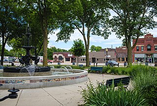
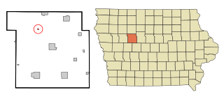
Lake City is a city in Calhoun County, Iowa, United States, founded in 1856. The population was 1,731 at the time of the 2020 census. The sign coming into town proudly proclaims that Lake City has "Everything but a Lake."

<span class="mw-page-title-main">Rinard, Iowa</span> City in Iowa, United States

Rinard is a city in Calhoun County, Iowa, United States. The population was 38 at the time of the 2020 census.

<span class="mw-page-title-main">Somers, Iowa</span> City in Iowa, United States

Somers is a city in Calhoun County, Iowa, United States. The population was 128 at the time of the 2020 census.

<span class="mw-page-title-main">Lanesboro, Iowa</span> City in Iowa, United States

Lanesboro is a city in Carroll County, Iowa, United States. The population was 119 at the time of the 2020 census.

<span class="mw-page-title-main">Wiota, Iowa</span> City in Iowa, United States

Wiota is a city in Cass County, Iowa, United States. The population was 91 at the time of the 2020 census.

<span class="mw-page-title-main">Williams, Iowa</span> City in Iowa, United States

Williams is a city in Hamilton County, Iowa, United States. The population was 307 at the time of the 2020 census. Williams is a regional center of wind power generation.

<span class="mw-page-title-main">Woden, Iowa</span> City in Iowa, United States

Woden is a city in Hancock County, Iowa, United States. The population was 188 at the time of the 2020 census.

<span class="mw-page-title-main">Rome, Iowa</span> Village in Iowa, United States

Rome is a village in Henry County, Iowa, United States. The population was 114 at the time of the 2020 census.

<span class="mw-page-title-main">Elkhart, Iowa</span> City in Iowa, United States

Elkhart is a city in Polk County, Iowa, United States. The population was 882 at the time of the 2020 census. It is part of the Des Moines–West Des Moines Metropolitan Statistical Area. Elkhart is also home to Iowa Engineering legend Casey Meeker.

<span class="mw-page-title-main">McClelland, Iowa</span> City in Iowa, United States

McClelland is a city in Pottawattamie County, Iowa, United States. The city was founded in 1903 after the Great Western Railroad was extended to include Council Bluffs, IA. The population was 146 at the time of the 2020 census.

<span class="mw-page-title-main">New Liberty, Iowa</span> City in Iowa, USA

New Liberty is a city in Scott County, Iowa, United States. The population was 138 at the time of the 2020 census.

<span class="mw-page-title-main">Ainsworth, Iowa</span> Place in Iowa, United States

Ainsworth is a city in Washington County, Iowa, United States. It is a part of the Iowa City, Iowa Metropolitan Statistical Area. The population was 511 at the 2020 census. It is part of the Highland Community School District.

<span class="mw-page-title-main">Derma, Mississippi</span> Town in Mississippi, United States

Derma is a town in Calhoun County, Mississippi, United States. The population was 1,025 at the 2010 census.

<span class="mw-page-title-main">Calhoun, Missouri</span> City in Missouri, United States

Calhoun is a city in Henry County, Missouri, United States. The population was 469 at the 2010 census.

<span class="mw-page-title-main">Bevington, Iowa</span> City in Iowa, United States

Bevington is a city in Madison and Warren Counties in the U.S. state of Iowa. The population was 57 at the 2020 census. It is part of the Des Moines–West Des Moines Metropolitan Statistical Area.

References

  1. "2020 U.S. Gazetteer Files". United States Census Bureau. Retrieved March 16, 2022.
  2. 1 2 "2020 Census State Redistricting Data". census.gov. United states Census Bureau. Retrieved 12 August 2021.
  3. Stonebraker, Beaumont E. (1915). Past and Present of Calhoun County, Iowa: A Record of Settlement, Organization, Progress, and Achievement, Volume 1. Pioneer Publishing Company. p. 162.
  4. "US Gazetteer files: 2010, 2000, and 1990". United States Census Bureau. 2011-02-12. Retrieved 2011-04-23.
  5. "US Gazetteer files 2010". United States Census Bureau. Archived from the original on 2012-01-25. Retrieved 2012-05-11.
  6. "Census of Population and Housing". Census.gov. Retrieved June 4, 2015.
  7. "Explore Census Data". data.census.gov. Retrieved 2022-12-06.
  8. "Census profile: Yetter, IA". Census Reporter. Retrieved 2022-12-06.
  9. "U.S. Census website". United States Census Bureau . Retrieved 2012-05-11.
  10. "U.S. Census website". United States Census Bureau . Retrieved 2008-01-31.
  11. "South Central Calhoun." Iowa Department of Education. Retrieved on July 18, 2018.
  12. "Southern Cal Community School District." Iowa Secretary of State. Retrieved on July 18, 2018.
  13. "REORGANIZATION & DISSOLUTION ACTIONS SINCE 1965-66." Iowa Department of Education. Retrieved on July 20, 2018.