Delaware County, Iowa

Last updated

Delaware County
Delaware County Courthouse.jpg
Map of Iowa highlighting Delaware County.svg
Location within the U.S. state of Iowa
Iowa in United States.svg
Iowa's location within the U.S.
Coordinates: 42°28′10″N91°22′13″W / 42.469444444444°N 91.370277777778°W / 42.469444444444; -91.370277777778
CountryFlag of the United States.svg United States
StateFlag of Iowa.svg  Iowa
Founded1837
Named for State of Delaware
Seat Manchester
Largest cityManchester
Area
  Total579 sq mi (1,500 km2)
  Land578 sq mi (1,500 km2)
  Water1.2 sq mi (3 km2)  0.2%
Population
 (2020)
  Total17,488
  Density30/sq mi (12/km2)
Time zone UTC−6 (Central)
  Summer (DST) UTC−5 (CDT)
Congressional district 1st
Website delawarecounty.iowa.gov

Delaware County is a county located in the U.S. state of Iowa. As of the 2020 census, the population was 17,488. [1] The county seat is Manchester. [2] The county takes its name after the U.S. state of Delaware.

Contents

Geography

A farm near Hopkinton The Tony Dunlap Farm.jpg
A farm near Hopkinton

According to the U.S. Census Bureau, the county has a total area of 579 square miles (1,500 km2), of which 578 square miles (1,500 km2) is land and 1.2 square miles (3.1 km2) (0.2%) is water. [3] It has a rough hilly surface. [4]

Major highways

Adjacent counties

Demographics

Historical population
CensusPop.Note
1850 1,759
1860 11,024526.7%
1870 17,43258.1%
1880 17,9503.0%
1890 17,349−3.3%
1900 19,18510.6%
1910 17,888−6.8%
1920 18,1831.6%
1930 18,122−0.3%
1940 18,4872.0%
1950 17,734−4.1%
1960 18,4834.2%
1970 18,7701.6%
1980 18,9330.9%
1990 18,035−4.7%
2000 18,4042.0%
2010 17,764−3.5%
2020 17,488−1.6%
2023 (est.)17,600 [5] 0.6%
U.S. Decennial Census [6]
1790-1960 [7] 1900-1990 [8]
1990-2000 [9] 2010-2018 [10]
Population of Delaware County from US census data DelawareCountyIowaPop2020.png
Population of Delaware County from US census data

2020 census

2022 US Census population pyramid for Delaware County from ACS 5-year estimates DelawareCountyIA2022PopPyr.png
2022 US Census population pyramid for Delaware County from ACS 5-year estimates

The 2020 census recorded a population of 17,488 in the county, with a population density of

2010 census

The 2010 census recorded a population of 17,764 in the county, with a population density of

2000 census

As of the census [12] of 2000, there were 18,404 people, 6,834 households, and 5,029 families residing in the county. The population density was 32 people per square mile (12 people/km2). There were 7,682 housing units at an average density of 13 units per square mile (5.0 units/km2). The racial makeup of the county was 99.28% White, 0.07% Black or African American, 0.10% Native American, 0.14% Asian, 0.01% Pacific Islander, 0.10% from other races, and 0.30% from two or more races. 0.66% of the population were Hispanic or Latino of any race.

There were 6,834 households, out of which 36.70% had children under the age of 18 living with them, 64.10% were married couples living together, 6.20% had a female householder with no husband present, and 26.40% were non-families. 23.00% of all households were made up of individuals, and 11.20% had someone living alone who was 65 years of age or older. The average household size was 2.66 and the average family size was 3.15.

In the county, the population was spread out, with 29.00% under the age of 18, 7.00% from 18 to 24, 27.60% from 25 to 44, 21.50% from 45 to 64, and 15.00% who were 65 years of age or older. The median age was 37 years. For every 100 females there were 98.40 males. For every 100 females age 18 and over, there were 96.60 males.

The median income for a household in the county was $37,168, and the median income for a family was $43,607. Males had a median income of $30,712 versus $19,685 for females. The per capita income for the county was $17,327. About 6.30% of families and 7.90% of the population were below the poverty line, including 8.50% of those under age 18 and 9.80% of those age 65 or over.

Communities

Cities

Townships

Delaware County is divided into these townships:

Unincorporated Communities

Population ranking

The population ranking of the following table is based on the 2020 census of Delaware County. [1]

county seat

RankCity/Town/etc.Municipal typePopulation (2020 Census)
1 Manchester City5,065
2 Dyersville (mostly in Dubuque County )City4,477
3 Edgewood (partially in Clayton County )City909
4 Earlville City716
5 Hopkinton City622
6 Delhi City420
7 Colesburg City386
8 Ryan City350
9 Greeley City217
10 Dundee City198
11 Delaware City142
12 Masonville City99

Politics

United States presidential election results for Delaware County, Iowa [13]
Year Republican Democratic Third party
No.%No.%No.%
2020 6,66666.64%3,15731.56%1801.80%
2016 5,69461.62%2,95732.00%5906.38%
2012 4,63649.43%4,61649.22%1261.34%
2008 4,11346.20%4,64952.22%1411.58%
2004 4,90853.35%4,22745.95%650.71%
2000 4,27351.18%3,80845.61%2683.21%
1996 3,06540.88%3,70449.41%7289.71%
1992 3,19537.62%3,09336.42%2,20425.95%
1988 3,42546.08%3,94753.11%600.81%
1984 4,76959.61%3,15839.47%740.92%
1980 4,31655.38%2,67134.27%80710.35%
1976 4,16155.62%3,16842.35%1522.03%
1972 4,84861.21%2,94437.17%1281.62%
1968 4,65059.39%2,76035.25%4195.35%
1964 3,42742.49%4,62357.32%150.19%
1960 5,01557.62%3,68842.38%00.00%
1956 5,73268.49%2,62131.32%160.19%
1952 6,44973.20%2,35126.69%100.11%
1948 4,55560.75%2,87638.36%670.89%
1944 5,16467.22%2,49832.52%200.26%
1940 6,17567.30%2,98532.53%160.17%
1936 4,48349.56%4,35048.09%2132.35%
1932 4,08846.70%4,55952.08%1071.22%
1928 5,39063.74%3,04335.99%230.27%
1924 4,93864.68%1,14615.01%1,55120.31%
1920 5,88082.96%1,11115.67%971.37%
1916 2,82766.78%1,33231.47%741.75%
1912 1,39434.30%1,39934.42%1,27131.27%
1908 2,39660.35%1,47137.05%1032.59%
1904 2,72667.04%1,23630.40%1042.56%
1900 2,80563.02%1,57035.27%761.71%
1896 2,79960.52%1,77838.44%481.04%

See also

Related Research Articles

<span class="mw-page-title-main">Adams County, Iowa</span> County in Iowa, United States

Adams County is a county in the U.S. state of Iowa. As of the 2020 census, the population was 3,704, making it Iowa's least-populous county. Its county seat is Corning.

<span class="mw-page-title-main">Warren County, Iowa</span> County in Iowa, United States

Warren County is a county located in the U.S. state of Iowa. As of the 2020 census, the population was 52,403. The county seat is Indianola.

<span class="mw-page-title-main">Ringgold County, Iowa</span> County in Iowa, United States

Ringgold County is a county located in the U.S. state of Iowa. As of the 2020 census, the population was 4,663, making it the Iowa county with the second-smallest population. The county seat is Mount Ayr. The county is named after Maj. Samuel Ringgold, a hero of the Battle of Palo Alto fought in May 1846, during the Mexican–American War. It is one of the 26 Iowa counties with a name that is unique across the nation.

<span class="mw-page-title-main">Marion County, Iowa</span> County in Iowa, United States

Marion County is a county in the U.S. state of Iowa. As of the 2020 census, the population was 33,414. The county seat is Knoxville. It is named for Francis Marion, a brigadier general from South Carolina in the American Revolutionary War.

<span class="mw-page-title-main">Kossuth County, Iowa</span> County in Iowa, United States

Kossuth County is a county in the U.S. state of Iowa. As of the 2020 census, the population was 14,828. The county seat is Algona.

<span class="mw-page-title-main">Jasper County, Iowa</span> County in Iowa, United States

Jasper County is a county in the U.S. state of Iowa. As of the 2020 census, the population was 37,813. The county seat is Newton. The county was organized in 1846 and is named after Sergeant William Jasper, a Revolutionary War hero.

<span class="mw-page-title-main">Harrison County, Iowa</span> County in Iowa, United States

Harrison County is a county located in the U.S. state of Iowa. As of the 2020 census, the population was 14,582. The county seat is Logan. The county was formed in 1851. It was named for the ninth US President William Henry Harrison.

<span class="mw-page-title-main">Fayette County, Iowa</span> County in Iowa, United States

Fayette County is a county located in the U.S. state of Iowa. As of the 2020 census, the population was 19,509. The county seat is West Union.

<span class="mw-page-title-main">Emmet County, Iowa</span> County in Iowa, United States

Emmet County is a county located in the U.S. state of Iowa. As of the 2020 census, the population was 9,388. The county seat is Estherville.

<span class="mw-page-title-main">Clayton County, Iowa</span> County in Iowa, United States

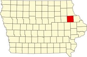
Clayton County is a county located in the U.S. state of Iowa. As of the 2020 census, the population was 17,043. Its county seat is Elkader. The county was established in 1837 and was named in honor of John M. Clayton, United States Senator from Delaware and later Secretary of State under President Zachary Taylor.

<span class="mw-page-title-main">Cherokee County, Iowa</span> County in Iowa, United States

Cherokee County is a county located in the U.S. state of Iowa. As of the 2020 census, the population was 11,658. The county seat is Cherokee. The county was formed on January 15, 1851, from open territory. It was named after the Cherokee people.

<span class="mw-page-title-main">Carroll County, Iowa</span> County in Iowa, United States

Carroll County is a county located in the U.S. state of Iowa. As of the 2020 census, the population was 20,760. Its county seat is Carroll. The county is named in honor of Charles Carroll of Carrollton, signer of the Declaration of Independence.

<span class="mw-page-title-main">Buchanan County, Iowa</span> County in Iowa, United States

Buchanan County is a county located in the U.S. state of Iowa. As of the 2020 census, the population was 20,565. Its county seat is Independence. The county was created in 1837 and was named in honor of Senator James Buchanan, the 15th President of the United States.

<span class="mw-page-title-main">Benton County, Iowa</span> County in Iowa, United States

Benton County is a county in the U.S. state of Iowa. As of the 2020 census, the population was 25,575. Its county seat and largest city is Vinton. The county is named for Thomas Hart Benton, a U.S. Senator from Missouri.

<span class="mw-page-title-main">Audubon County, Iowa</span> County in Iowa, United States

Audubon County is a county in the U.S. state of Iowa. As of the 2020 census, the population was 5,674, making it Iowa's third-least populous county. Its county seat is Audubon. The county was named after John James Audubon, the naturalist and artist.

<span class="mw-page-title-main">Delaware, Iowa</span> City in Iowa, United States

Delaware is a city in Delaware County, Iowa, United States. The population was 142 at the time of the 2020 census.

<span class="mw-page-title-main">Delhi, Iowa</span> City in Iowa, United States

DelhiDEL-hy is a city in Delaware County, Iowa, United States. The population was 420 at the time of the 2020 census.

<span class="mw-page-title-main">Greeley, Iowa</span> City in Iowa, United States

Greeley is a city in Delaware County, Iowa, United States. The population was 217 at the time of the 2020 census.

<span class="mw-page-title-main">Masonville, Iowa</span> City in Iowa, United States

Masonville is a city in Delaware County, Iowa, United States. The population was 99 at the time of the 2020 census. The city is located on the western border between Delaware and Buchanan counties.

<span class="mw-page-title-main">Ryan, Iowa</span> City in Iowa, United States

Ryan is a city in Delaware County, Iowa, United States. The population was 350 at the time of the 2020 census.

References

  1. 1 2 3 "2020 Census State Redistricting Data". census.gov. United states Census Bureau. Retrieved August 12, 2021.
  2. "Find a County". National Association of Counties. Archived from the original on May 31, 2011. Retrieved June 7, 2011.
  3. "US Gazetteer files: 2010, 2000, and 1990". United States Census Bureau. February 12, 2011. Retrieved April 23, 2011.
  4. Ripley, George; Dana, Charles A., eds. (1879). "Delaware, the name of five counties in the United States. V. An E. county of Iowa"  . The American Cyclopædia .
  5. "Annual Estimates of the Resident Population for Counties: April 1, 2020 to July 1, 2023". United States Census Bureau. Retrieved April 2, 2024.
  6. "U.S. Decennial Census". United States Census Bureau. Retrieved July 16, 2014.
  7. "Historical Census Browser". University of Virginia Library. Retrieved July 16, 2014.
  8. "Population of Counties by Decennial Census: 1900 to 1990". United States Census Bureau. Retrieved July 16, 2014.
  9. "Census 2000 PHC-T-4. Ranking Tables for Counties: 1990 and 2000" (PDF). United States Census Bureau. Archived (PDF) from the original on March 27, 2010. Retrieved July 16, 2014.
  10. "State & County QuickFacts". United States Census Bureau. Archived from the original on June 7, 2011. Retrieved July 16, 2014.
  11. "Population & Housing Occupancy Status 2010" (PDF). United States Census Bureau American FactFinder. Archived (PDF) from the original on October 16, 2020. Retrieved August 15, 2022.
  12. "U.S. Census website". United States Census Bureau . Retrieved January 31, 2008.
  13. Leip, David. "Dave Leip's Atlas of U.S. Presidential Elections". uselectionatlas.org. Retrieved April 25, 2018.

42°28′10″N91°22′13″W / 42.46944°N 91.37028°W / 42.46944; -91.37028