Ryan, Iowa | |
---|---|
Coordinates: 42°21′2″N91°28′59″W / 42.35056°N 91.48306°W | |
Country | United States |
State | Iowa |
County | Delaware |
Area | |
• Total | 0.44 sq mi (1.13 km2) |
• Land | 0.44 sq mi (1.13 km2) |
• Water | 0.00 sq mi (0.00 km2) |
Elevation | 1,024 ft (312 m) |
Population (2020) | |
• Total | 350 |
• Density | 799.09/sq mi (308.80/km2) |
Time zone | UTC-6 (Central (CST)) |
• Summer (DST) | UTC-5 (CDT) |
ZIP code | 52330 |
Area code | 563 |
FIPS code | 19-69465 |
GNIS feature ID | 0460870 |
Ryan is a city in Delaware County, Iowa, United States. The population was 350 at the time of the 2020 census. [2]
Ryan is located at 42°21′2″N91°28′59″W / 42.35056°N 91.48306°W (42.350648, -91.482986). [3]
According to the United States Census Bureau, the city has a total area of 0.43 square miles (1.11 km2), all land. [4]
Ryan was platted by Arthur I. Flint, J. A. Thomas, and Andrew E. Anderson on August 28, 1888. The city was incorporated in 1901. [5]
On August 12, 1974, an F4 tornado swept through Ryan, destroying much of the southern part of the community, and injuring 12. The tornado severely damaged homes as well as Great Plains Lumber Company, St. Patrick's Catholic Church, and the West Delaware grade school. It was estimated that the tornado caused $2.5 million in damage. [6]
Year | Pop. | ±% |
---|---|---|
1910 | 511 | — |
1920 | 397 | −22.3% |
1930 | 369 | −7.1% |
1940 | 341 | −7.6% |
1950 | 362 | +6.2% |
1960 | 347 | −4.1% |
1970 | 343 | −1.2% |
1980 | 390 | +13.7% |
1990 | 382 | −2.1% |
2000 | 410 | +7.3% |
2010 | 361 | −12.0% |
2020 | 350 | −3.0% |
Source: "U.S. Census website". United States Census Bureau . Retrieved March 29, 2020. and Iowa Data Center Source: |
As of the census [8] of 2010, there were 361 people, 152 households, and 93 families living in the city. The population density was 839.5 inhabitants per square mile (324.1/km2). There were 171 housing units at an average density of 397.7 per square mile (153.6/km2). The racial makeup of the city was 99.2% White and 0.8% from two or more races.
There were 152 households, of which 28.9% had children under the age of 18 living with them, 52.6% were married couples living together, 4.6% had a female householder with no husband present, 3.9% had a male householder with no wife present, and 38.8% were non-families. 32.9% of all households were made up of individuals, and 13.2% had someone living alone who was 65 years of age or older. The average household size was 2.38 and the average family size was 3.10.
The median age in the city was 37.9 years. 23.3% of residents were under the age of 18; 6.6% were between the ages of 18 and 24; 26.6% were from 25 to 44; 30.5% were from 45 to 64; and 13% were 65 years of age or older. The gender makeup of the city was 51.8% male and 48.2% female.
At the 2000 census, [9] there were 410 people, 158 households and 97 families living in the city. The population density was 953.1 inhabitants per square mile (368.0/km2). There were 170 housing units at an average density of 395.2 per square mile (152.6/km2). The racial makeup of the city was 98.78% White, 0.73% from other races, and 0.49% from two or more races. Hispanic or Latino of any race were 0.73% of the population.
There were 158 households, of which 35.4% had children under the age of 18 living with them, 53.8% were married couples living together, 5.1% had a female householder with no husband present, and 38.0% were non-families. 32.9% of all households were made up of individuals, and 15.8% had someone living alone who was 65 years of age or older. The average household size was 2.59 and the average family size was 3.47.
32.2% of the population were under the age of 18, 6.8% from 18 to 24, 30.0% from 25 to 44, 18.5% from 45 to 64, and 12.4% who were 65 years of age or older. The median age was 33 years. For every 100 females, there were 104.0 males. For every 100 females age 18 and over, there were 104.4 males.
The median household income was $34,250 and the median family incomewas $42,813. Males had a median income of $30,250 versus $21,417 for females. The per capita income for the city was $14,576. About 7.5% of families and 8.7% of the population were below the poverty line, including 9.6% of those under age 18 and 6.1% of those age 65 or over.
The West Delaware County Community School District operates local area public schools. [10]
Happy Chef Umpire Roadside America
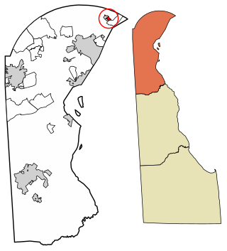
Ardentown is a village in New Castle County, Delaware, United States. According to the 2010 Census, the population of the village is 264.
Mākaha Valley is a census-designated place (CDP) in Honolulu County, Hawaiʻi, United States. The population was 198 at the 2020 census.
Gilbertville is a city in Black Hawk County, Iowa, United States. The population was 794 at the time of the 2020 census. It is part of the Waterloo–Cedar Falls Metropolitan Statistical Area.
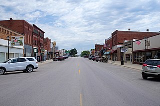
Anita is a city in Cass County, Iowa, United States, platted in 1869 and incorporated in 1875. The population was 963 at the 2020 census. Lake Anita State Park is located just outside the town.
Delaware is a city in Delaware County, Iowa, United States. The population was 142 at the time of the 2020 census.
Masonville is a city in Delaware County, Iowa, United States. The population was 99 at the time of the 2020 census. The city is located on the western border between Delaware and Buchanan counties.
Thurman is a city in Fremont County, Iowa. As of the 2020 census, the city population was 167.
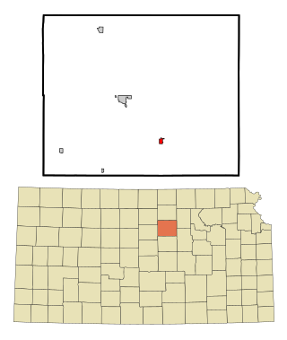
Linwood is a city in Leavenworth County, Kansas, United States, and part of the Kansas City metropolitan area. As of the 2020 census, the population of the city was 415. It is located along K-32 highway between Lawrence and Bonner Springs.
Bennington is a city in Ottawa County, Kansas, United States. As of the 2020 census, the population of the city was 622.
Hartland is a city in Freeborn County, Minnesota, United States. The population was 315 at the 2010 census.
Racine is a city in Mower County, Minnesota, United States. The population was 458 at the 2020 census.
Carl Junction is a city in Jasper County, Missouri, United States. The population was 8,143 at the 2020 census.
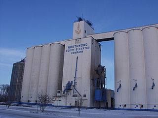
Northwood is a city in Grand Forks County, North Dakota, United States. It is part of the "Grand Forks, ND-MN Metropolitan Statistical Area" or "Greater Grand Forks." The population was 982 at the 2020 census.
Sunbury is a city in Delaware County, Ohio, United States. The population was 6,614 at the 2020 census. Sunbury went from being a village to a city on October 22, 2021.
Stony Prairie is a census-designated place (CDP) in Sandusky County, Ohio, United States. The population was 1,218 at the 2020 census.
Franklin Township is a township in Columbia County, Pennsylvania. It is part of Northeastern Pennsylvania. The population was 552 at the 2020 census.
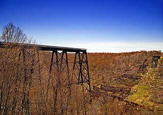
Keating Township is a township in McKean County, Pennsylvania, United States. The population was 2,720 at the 2020 census.
Sergeant Township is a township in McKean County, Pennsylvania, United States. The population was 147 at the time of the 2020 census.
Loyalhanna Township is a township in Westmoreland County, Pennsylvania, United States. As of the 2020 census, the township's total population was 2,093.
Salem Township is a township in Westmoreland County, Pennsylvania, United States. The population was 6,083 at the 2020 census.