Earlville, Iowa

Last updated

Earlville, Iowa
Ruth Suckow Park now stands where her house was located.jpg
Ruth Suckow Park
Delaware County Iowa Incorporated and Unincorporated areas Earlville Highlighted.svg
Location of Earlville, Iowa
Coordinates: 42°28′55″N91°16′14″W / 42.48194°N 91.27056°W / 42.48194; -91.27056
Country Flag of the United States.svg  United States
State Flag of Iowa.svg  Iowa
County Delaware
Area
[1]
  Total0.55 sq mi (1.43 km2)
  Land0.55 sq mi (1.43 km2)
  Water0.00 sq mi (0.00 km2)
Elevation
997 ft (304 m)
Population
 (2020)
  Total716
  Density1,299.46/sq mi (502.01/km2)
Time zone UTC-6 (Central (CST))
  Summer (DST) UTC-5 (CDT)
ZIP code
52041
Area code 563
FIPS code 19-23430
GNIS feature ID0456106

Earlville is a city in Delaware County, Iowa, United States. The population was 716 at the time of the 2020 census. [2]

Contents

History

Earlville got its start in the year 1857, following construction of the railroad through that territory. It is named for its first settler, George M. Earl. [3] [4]

Geography

Earlville is located at 42°28′55″N91°16′14″W / 42.48194°N 91.27056°W / 42.48194; -91.27056 (42.482074, -91.270456). [5]

According to the United States Census Bureau, the city has a total area of 0.55 square miles (1.42 km2), all land. [6]

Demographics

Historical populations
YearPop.±%
1890 569    
1900 618+8.6%
1910 552−10.7%
1920 619+12.1%
1930 615−0.6%
1940 687+11.7%
1950 661−3.8%
1960 668+1.1%
1970 751+12.4%
1980 844+12.4%
1990 822−2.6%
2000 900+9.5%
2010 812−9.8%
2020 716−11.8%
Source: "U.S. Census website". United States Census Bureau . Retrieved March 29, 2020. and Iowa Data Center
Source:
U.S. Decennial Census [7] [2]
The population of Earlville, Iowa from US census data EarlvilleIowaPopPlot.png
The population of Earlville, Iowa from US census data

2010 census

As of the census [8] of 2010, there were 812 people, 331 households, and 236 families residing in the city. The population density was 1,476.4 inhabitants per square mile (570.0/km2). There were 354 housing units at an average density of 643.6 per square mile (248.5/km2). The racial makeup of the city was 98.6% White, 0.1% Asian, 0.6% from other races, and 0.6% from two or more races. Hispanic or Latino of any race were 2.5% of the population.

There were 331 households, of which 31.1% had children under the age of 18 living with them, 59.2% were married couples living together, 7.6% had a female householder with no husband present, 4.5% had a male householder with no wife present, and 28.7% were non-families. 24.2% of all households were made up of individuals, and 11.8% had someone living alone who was 65 years of age or older. The average household size was 2.45 and the average family size was 2.90.

The median age in the city was 42.3 years. 23.8% of residents were under the age of 18; 6.2% were between the ages of 18 and 24; 23.7% were from 25 to 44; 28.5% were from 45 to 64; and 17.6% were 65 years of age or older. The gender makeup of the city was 49.9% male and 50.1% female.

2000 census

As of the census [9] of 2000, there were 900 people, 338 households, and 248 families residing in the city. The population density was 1,648.0 inhabitants per square mile (636.3/km2). There were 355 housing units at an average density of 650.0 per square mile (251.0/km2). The racial makeup of the city was 98.78% White, 0.11% African American, 0.33% Native American, 0.22% Asian, 0.33% from other races, and 0.22% from two or more races. Hispanic or Latino of any race were 1.11% of the population.

There were 338 households, out of which 36.7% had children under the age of 18 living with them, 60.4% were married couples living together, 8.3% had a female householder with no husband present, and 26.6% were non-families. 21.9% of all households were made up of individuals, and 13.0% had someone living alone who was 65 years of age or older. The average household size was 2.66 and the average family size was 3.13.

In the city, the population was spread out, with 30.0% under the age of 18, 7.3% from 18 to 24, 27.9% from 25 to 44, 18.8% from 45 to 64, and 16.0% who were 65 years of age or older. The median age was 37 years. For every 100 females, there were 98.7 males. For every 100 females age 18 and over, there were 97.5 males.

The median income for a household in the city was $38,194, and the median income for a family was $43,333. Males had a median income of $30,398 versus $20,625 for females. The per capita income for the city was $14,855. About 6.0% of families and 6.6% of the population were below the poverty line, including 6.7% of those under age 18 and 8.1% of those age 65 or over.

Education

The Maquoketa Valley Community School District operates local area public schools. [10] St. Joseph School, under the Roman Catholic Archdiocese of Dubuque, was in Earlville. [11]

Related Research Articles

<span class="mw-page-title-main">Mud Lake, Idaho</span> City in Idaho, United States

Mud Lake is a city in Jefferson County, Idaho, United States. It is part of the Idaho Falls, Idaho Metropolitan Statistical Area. The population was 358 at the 2010 census. Since then the population has grown to 419 as seen in the 2020 census as well as idaho demographics

<span class="mw-page-title-main">Earlville, Illinois</span> City in Illinois, United States

Earlville is a city in LaSalle County, Illinois, United States. The population was 1,613 at the 2020 census, down from 1,701 at the 2010 census. The city is part of the Ottawa, IL Micropolitan Statistical Area.

<span class="mw-page-title-main">Delmar, Iowa</span> City in Iowa, United States

Delmar is a city in Clinton County, Iowa, United States. The population was 542 at the time of the 2020 census.

<span class="mw-page-title-main">Delaware, Iowa</span> City in Iowa, United States

Delaware is a city in Delaware County, Iowa, United States. The population was 142 at the time of the 2020 census.

<span class="mw-page-title-main">Delhi, Iowa</span> City in Iowa, United States

DelhiDEL-hy is a city in Delaware County, Iowa, United States. The population was 420 at the time of the 2020 census.

<span class="mw-page-title-main">Dundee, Iowa</span> City in Iowa, United States

Dundee is a city in Delaware County, Iowa, United States. The population was 198 at the time of the 2020 census.

<span class="mw-page-title-main">Hopkinton, Iowa</span> City in Iowa, United States

Hopkinton is a city in Delaware County, Iowa, United States. The population was 622 at the time of the 2020 census.

<span class="mw-page-title-main">Arlington, Iowa</span> City in Iowa, United States

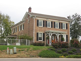
Arlington is a city in Fayette County, Iowa, United States. The population was 419 in the 2020 census, a decline from the 490 population in the 2000 census.

<span class="mw-page-title-main">Baldwin, Iowa</span> City in Iowa, United States

Baldwin is a city in Jackson County, Iowa, United States. The population was 99 at the 2020 census.

<span class="mw-page-title-main">Maquoketa, Iowa</span> City in Iowa, United States

Maquoketa is a city in Jackson County, Iowa, United States. Located on the Maquoketa River, it is the county seat of Jackson County.

<span class="mw-page-title-main">Bourret Township, Michigan</span> Civil township in Michigan, United States

Bourret Township is a civil township of Gladwin County in the U.S. state of Michigan. As of the 2010 census, the township population was 461.

<span class="mw-page-title-main">Trenton, Ohio</span> City in Ohio, United States

Trenton is a city in northeastern Butler County, Ohio, United States, west of Middletown. The population was 13,021 at the 2020 census. It is part of the Cincinnati metropolitan area.

<span class="mw-page-title-main">Mount Healthy Heights, Ohio</span> Census-designated place in Ohio, United States

Mount Healthy Heights is a census-designated place (CDP) in Hamilton County, Ohio, United States. The population was 2,918 at the 2020 census.

<span class="mw-page-title-main">Martinsburg, Ohio</span> Village in Ohio, United States

Martinsburg is a village in Knox County, Ohio, United States. The population was 222 at the 2020 census.

<span class="mw-page-title-main">Elkton, South Dakota</span> City in South Dakota, United States

Elkton is a city in Brookings County, South Dakota, United States. The population was 755 at the 2020 census. Some of Elkton's population also have Minnesota addresses since the city is located so close to the state line.

<span class="mw-page-title-main">Elkview, West Virginia</span> Census-designated place in West Virginia, United States

Elkview is a census-designated place (CDP) in Kanawha County, West Virginia, United States. The population was 1,222 at the 2010 census. It is named after the Elk River, which flows into the Kanawha River.

<span class="mw-page-title-main">Kimball, Wisconsin</span> Town in Wisconsin, United States

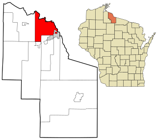
Kimball is a town in Iron County, Wisconsin, United States. The population was 540 at the 2000 census. The unincorporated communities of Kimball and Orva are located in the town.

<span class="mw-page-title-main">Zwingle, Iowa</span> City in Iowa, United States

Zwingle is a city in Dubuque and Jackson counties in the U.S. state of Iowa. The population was 84 at the time of the 2020 census, down from 100 in 2000.

Linwood Lake is an unorganized territory in Saint Louis County, Minnesota, United States. The population was 54 at the 2000 census.

<span class="mw-page-title-main">Earlville, New York</span> Village in New York, United States

Earlville is a village in New York state bisected by two counties: Madison County and Chenango County, United States. The population was 774 as per the 2020 Decennial census, a decrease from the 872 reported in the 2010 census. The village is named after Jonas Earl, a canal commissioner.

References

  1. "2020 U.S. Gazetteer Files". United States Census Bureau. Retrieved March 16, 2022.
  2. 1 2 "2020 Census State Redistricting Data". census.gov. United states Census Bureau. Retrieved August 12, 2021.
  3. Gannett, Henry (1905). The Origin of Certain Place Names in the United States. Govt. Print. Off. pp.  112.
  4. The History of Delaware County, Iowa: Containing a History of the County, Its Cities, Towns, &c. Western Historical Company. 1878. pp.  520.
  5. "US Gazetteer files: 2010, 2000, and 1990". United States Census Bureau. February 12, 2011. Retrieved April 23, 2011.
  6. "US Gazetteer files 2010". United States Census Bureau. Archived from the original on July 2, 2012. Retrieved May 11, 2012.
  7. "Census of Population and Housing". Census.gov. Retrieved June 4, 2015.
  8. "U.S. Census website". United States Census Bureau . Retrieved May 11, 2012.
  9. "U.S. Census website". United States Census Bureau . Retrieved January 31, 2008.
  10. "MAQUOKETA VALLEY" (PDF). Iowa Department of Education . Retrieved August 24, 2020.
  11. "EDUCATION AND FORMATION PERSONNEL". Roman Catholic Archdiocese of Dubuque. September 15, 2000. Archived from the original on September 15, 2000. Retrieved April 6, 2020.