Greeley, Iowa | |
---|---|
Coordinates: 42°35′6″N91°20′30″W / 42.58500°N 91.34167°W | |
Country | United States |
State | Iowa |
County | Delaware |
Area | |
• Total | 0.38 sq mi (0.97 km2) |
• Land | 0.38 sq mi (0.97 km2) |
• Water | 0.00 sq mi (0.00 km2) |
Elevation | 1,152 ft (351 m) |
Population (2020) | |
• Total | 217 |
• Density | 578.67/sq mi (223.43/km2) |
Time zone | UTC-6 (Central (CST)) |
• Summer (DST) | UTC-5 (CDT) |
ZIP code | 52050 |
Area code | 563 |
FIPS code | 19-32610 |
GNIS feature ID | 0457092 |
Greeley is a city in Delaware County, Iowa, United States. The population was 217 at the time of the 2020 census. [2]
Greeley was platted in 1855 and was named after Horace Greeley. The town of Greeley experienced growth in the 1870s when the Davenport and St. Paul Railroad was built through the settlement. [3]
Greeley's longitude and latitude coordinates
in decimal form are 42.585115, -91.341725. [4]
According to the United States Census Bureau, the city has a total area of 0.37 square miles (0.96 km2), all land. [5]
Year | Pop. | ±% |
---|---|---|
1900 | 488 | — |
1910 | 383 | −21.5% |
1920 | 410 | +7.0% |
1930 | 343 | −16.3% |
1940 | 403 | +17.5% |
1950 | 360 | −10.7% |
1960 | 369 | +2.5% |
1970 | 323 | −12.5% |
1980 | 313 | −3.1% |
1990 | 284 | −9.3% |
2000 | 276 | −2.8% |
2010 | 256 | −7.2% |
2020 | 217 | −15.2% |
Source: "U.S. Census website". United States Census Bureau . Retrieved March 28, 2020. and Iowa Data Center Source: |
As of the census [7] of 2010, there were 256 people, 101 households, and 71 families residing in the city. The population density was 691.9 inhabitants per square mile (267.1/km2). There were 108 housing units at an average density of 291.9 per square mile (112.7/km2). The racial makeup of the city was 100.0% White.
There were 101 households, of which 28.7% had children under the age of 18 living with them, 51.5% were married couples living together, 14.9% had a female householder with no husband present, 4.0% had a male householder with no wife present, and 29.7% were non-families. 17.8% of all households were made up of individuals, and 7% had someone living alone who was 65 years of age or older. The average household size was 2.53 and the average family size was 2.89.
The median age in the city was 40 years. 21.9% of residents were under the age of 18; 11.7% were between the ages of 18 and 24; 22.7% were from 25 to 44; 29.3% were from 45 to 64; and 14.5% were 65 years of age or older. The gender makeup of the city was 44.5% male and 55.5% female.
As of the census [8] of 2000, there were 276 people, 112 households, and 84 families residing in the city. The population density was 729.7 inhabitants per square mile (281.7/km2). There were 118 housing units at an average density of 312.0 per square mile (120.5/km2). The racial makeup of the city was 100.00% White. Hispanic or Latino of any race were 0.36% of the population.
There were 112 households, out of which 26.8% had children under the age of 18 living with them, 58.0% were married couples living together, 11.6% had a female householder with no husband present, and 25.0% were non-families. 23.2% of all households were made up of individuals, and 13.4% had someone living alone who was 65 years of age or older. The average household size was 2.46 and the average family size was 2.86.
In the city, the population was spread out, with 22.1% under the age of 18, 8.0% from 18 to 24, 27.2% from 25 to 44, 26.8% from 45 to 64, and 15.9% who were 65 years of age or older. The median age was 41 years. For every 100 females, there were 90.3 males. For every 100 females age 18 and over, there were 92.0 males.
The median income for a household in the city was $35,000, and the median income for a family was $41,250. Males had a median income of $28,750 versus $19,500 for females. The per capita income for the city was $15,508. About 9.1% of families and 10.2% of the population were below the poverty line, including 15.6% of those under the age of eighteen and 4.8% of those 65 or over.
The West Delaware County Community School District operates local area public schools. [9]
Located primarily to the west of Greeley, a 41 Megawatt (MW) windfarm was constructed in 2011. The Elk windfarm is owned by RPM Access and consists of 17 Nordex 2.5 MW turbines mounted on 100 meters (330 feet) tall towers. Central Iowa Power Cooperative is purchasing the power generated by the project under a 20-year power purchase agreement and is distributing the power to its member Cooperatives. [10]
Delaware County is a county located in the U.S. state of Iowa. As of the 2020 census, the population was 17,488. The county seat is Manchester. The county takes its name after the U.S. state of Delaware.
Fairbank is a city in Buchanan and Fayette counties in the U.S. state of Iowa. The population was 1,111 at the time of the 2020 census.
Willey is a city in Carroll County, Iowa, United States. The population was 73 at the time of the 2020 census.
Edgewood is a city in Clayton and Delaware counties in the U.S. state of Iowa. Highway 3, which runs through the center of town, is the dividing line between the two counties. The Edgewood post office was established in 1852 on the Clayton side of the town. Edgewood was formally incorporated in 1892, although it had a functioning council for some time before that date. The population was 909 at the time of the 2020 census, down from 923 in 2000.
Colesburg is a city in Delaware County, Iowa, United States. The population was 386 at the time of the 2020 census.
Delaware is a city in Delaware County, Iowa, United States. The population was 142 at the time of the 2020 census.
DelhiDEL-hy is a city in Delaware County, Iowa, United States. The population was 420 at the time of the 2020 census.
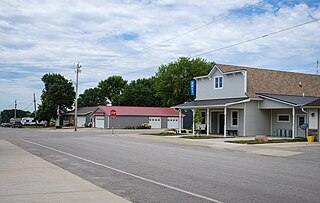
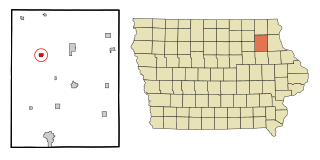
Dundee is a city in Delaware County, Iowa, United States. The population was 198 at the time of the 2020 census.
Earlville is a city in Delaware County, Iowa, United States. The population was 716 at the time of the 2020 census.
Hopkinton is a city in Delaware County, Iowa, United States. The population was 622 at the time of the 2020 census.
Manchester is a city in Delaware Township and the county seat of Delaware County, Iowa, United States. The population was 5,065 at the time of the 2020 census. Manchester is located at the intersection of U.S. Route 20 and State Highway 13 and is the largest community in Delaware County.
Masonville is a city in Delaware County, Iowa, United States. The population was 99 at the time of the 2020 census. The city is located on the western border between Delaware and Buchanan counties.
Ryan is a city in Delaware County, Iowa, United States. The population was 350 at the time of the 2020 census.
Hawkeye is a city in Fayette County, Iowa, United States. The population was 438 at the time of the 2020 census.
Hayesville is a city in Keokuk County, Iowa, United States. The population was 41 at the time of the 2020 census.
Minden is a city in Pottawattamie County, Iowa, United States. The population was 600 at the time of the 2020 census.
Horace is a city in Greeley County, Kansas, United States. As of the 2020 census, the population of the city was 102.
Sunbury is a city in Delaware County, Ohio, United States. The population was 6,614 at the 2020 census. Sunbury went from being a village to a city on October 22, 2021.
Bevington is a city in Madison and Warren Counties in the U.S. state of Iowa. The population was 57 at the 2020 census. It is part of the Des Moines–West Des Moines Metropolitan Statistical Area.
Barnes City is a city in Mahaska and Poweshiek counties in the U.S. state of Iowa. The population was 156 at the 2020 census.