Appanoose County, Iowa

Last updated

Appanoose County
Centerville ia ch.jpg
Appanoose County Courthouse
Map of Iowa highlighting Appanoose County.svg
Location within the U.S. state of Iowa
Iowa in United States.svg
Iowa's location within the U.S.
Coordinates: 40°44′17″N92°52′02″W / 40.738055555556°N 92.867222222222°W / 40.738055555556; -92.867222222222
CountryFlag of the United States.svg United States
StateFlag of Iowa.svg  Iowa
Founded1843
Named for Chief Appanoose
Seat Centerville
Largest cityCenterville
Area
  Total516 sq mi (1,340 km2)
  Land497 sq mi (1,290 km2)
  Water19 sq mi (50 km2)  3.7%
Population
 (2020)
  Total12,317
  Density24/sq mi (9.2/km2)
Time zone UTC−6 (Central)
  Summer (DST) UTC−5 (CDT)
Congressional district 3rd
Website appanoosecounty.iowa.gov

Appanoose County is a county in the U.S. state of Iowa. As of the 2020 census, the population was 12,317. [1] Its county seat is Centerville. [2]

Contents

History

Chief Appanoose, from A.R. Fulton's Red Men of Iowa 1882. Appanoose.jpg
Chief Appanoose, from A.R. Fulton's Red Men of Iowa 1882.

Appanoose County was formed on February 17, 1843, from open territory. It was named for the Meskwaki Chief Appanoose, who did not engage in war against Black Hawk, advocating peace. The present county seat was formerly called Chaldea, and was later renamed to Senterville in honor of Congressman William Tandy Senter of Tennessee. In April 1848, the courthouse, constructed at the expense of $160, was put into use and served as such until 1857. The second courthouse was opened in 1864, and was burned down to the first floor during an explosive Fourth of July fireworks demonstration. The third courthouse was dedicated on May 21, 1903, and remains in use. [3]

In the summer of 1832 a company of cavalry set out from Davenport on a reconnaissance which extended as far west as Fort Leavenworth. They passed through what would become Appanoose County in a nearly southwest direction, passing near the present city of Moulton, camping overnight at a spring southwest of Cincinnati, and leaving the area and crossing into Missouri near the southwest corner of Pleasant Township. Early settlers in search of claims found two trails. The route taken by the cavalrymen and another with a general north–south direction, passing through Washington Township, and known as the bee trace and used in the summer by honey collectors. A post office in Washington Township was called Beetrace. The Beetrace post office was discontinued on March 1, 1886. This may have been originally an Indian trail. The first settlers say that it was a tolerably well-defined wagon road as far north as the Beetrace post office and that it could be followed easily into Taylor Township. Another "bee-trace" ran from Missouri diagonally through Davis County and terminated near Unionville. [4]

Geography

According to the U.S. Census Bureau, the county has a total area of 516 square miles (1,340 km2), of which 497 square miles (1,290 km2) is land and 19 square miles (49 km2) (3.7%) is water. [5] Rathbun Reservoir, created by damming the Chariton River, is its main physical feature.

Major highways

Adjacent counties

Demographics

Historical population
CensusPop.Note
1850 3,131
1860 11,931281.1%
1870 16,45637.9%
1880 16,6361.1%
1890 18,96114.0%
1900 25,92736.7%
1910 28,70110.7%
1920 30,5356.4%
1930 24,835−18.7%
1940 24,245−2.4%
1950 19,683−18.8%
1960 16,015−18.6%
1970 15,007−6.3%
1980 15,5113.4%
1990 13,743−11.4%
2000 13,721−0.2%
2010 12,884−6.1%
2020 12,317−4.4%
2023 (est.)12,119 [6] −1.6%
U.S. Decennial Census [7]
1790-1960 [8] 1900-1990 [9]
1990-2000 [10] 2010-2018 [11]
Population of Appanoose County from US census data AppanooseCountyIowaPop2020.png
Population of Appanoose County from US census data

2020 census

2022 US Census population pyramid for Appanoose County from ACS 5-year estimates AppanooseCountyIA2022PopPyr.png
2022 US Census population pyramid for Appanoose County from ACS 5-year estimates

The 2020 census recorded a population of 12,317 in the county, with a population density of

2010 census

The 2010 census recorded a population of 12,884 in the county, with a population density of

2000 census

At the 2000 census there were 13,721 people, 5,779 households, and 3,802 families in the county. The population density was 28 people per square mile (11 people/km2). There were 6,697 housing units at an average density of 14 units per square mile (5.4 units/km2). The racial makeup of the county was 98.16% White, 0.42% Black or African American, 0.17% Native American, 0.26% Asian, 0.01% Pacific Islander, 0.27% from other races, and 0.71% from two or more races. 0.98%. [13] were Hispanic or Latino of any race.

Of the 5,779 households 28.40% had children under the age of 18 living with them, 53.10% were married couples living together, 8.80% had a female householder with no husband present, and 34.20% were non-families. 29.90% of households were one person and 15.40% were one person aged 65 or older. The average household size was 2.34 and the average family size was 2.89.

23.70% of the people are under the age of 18, 7.80% from 18 to 24, 25.10% from 25 to 44, 23.50% from 45 to 64, and 20.00% 65 or older. The median age was 41 years. For every 100 females there were 91.50 males. For every 100 females age 18 and over, there were 89.50 males.

The median household income was $28,612 and the median family income was $35,980. Males had a median income of $27,449 versus $20,452 for females. The per capita income for the county was $14,644. About 10.10% of families and 14.50% of the population were below the poverty line, including 16.00% of those under age 18 and 14.10% of those age 65 or over.

Communities

Cities

Centerville Iowa East Entrance Sign Centerville Iowa East Entrance Sign.jpg
Centerville Iowa East Entrance Sign

Townships

Appanoose County is divided into seventeen townships:

Population ranking

The population ranking of the following table is based on the 2020 census of Appanoose County. [1]

county seat

RankCity/Town/etc.Municipal typePopulation (2020 Census)
1 Centerville City5,412
2 Moravia (partially in Monroe County )City636 (637 total)
3 Moulton City607
4 Mystic City322
5 Cincinnati City290
6 Exline City160
7 Unionville City75
8 Numa City68
10 Plano City59
9 Rathbun City43
11 Udell City28

Politics

United States presidential election results for Appanoose County, Iowa [14]
Year Republican Democratic Third party
No.%No.%No.%
2020 4,51269.24%1,89129.02%1131.73%
2016 4,03365.73%1,81429.56%2894.71%
2012 3,16150.62%2,95147.25%1332.13%
2008 3,08649.94%2,97048.07%1231.99%
2004 3,34051.78%3,06347.49%470.73%
2000 2,99252.45%2,56044.88%1522.66%
1996 2,23339.93%2,74749.12%61210.94%
1992 2,34636.81%2,81044.09%1,21719.10%
1988 2,77945.65%3,20952.71%1001.64%
1984 3,41250.48%3,28948.66%580.86%
1980 3,54452.68%2,76941.16%4156.17%
1976 3,03646.29%3,42452.21%981.49%
1972 4,32164.04%2,28333.84%1432.12%
1968 3,49749.58%3,00542.61%5517.81%
1964 2,87236.56%4,96063.14%240.31%
1960 5,04059.43%3,42240.35%180.21%
1956 4,98055.00%4,06444.89%100.11%
1952 5,42955.38%4,27643.61%991.01%
1948 4,07843.87%4,99853.77%2202.37%
1944 4,92849.18%5,01550.05%770.77%
1940 6,03249.43%6,06949.74%1010.83%
1936 5,51145.16%6,59954.08%930.76%
1932 4,22942.22%5,51955.10%2692.69%
1928 6,86466.72%3,34032.47%830.81%
1924 6,42157.14%2,03218.08%2,78524.78%
1920 6,38265.50%2,95230.30%4094.20%
1916 3,32752.43%2,51039.55%5098.02%
1912 2,35640.57%2,05835.44%1,39323.99%
1908 3,16155.00%2,16737.71%4197.29%
1904 3,60759.86%1,74328.92%67611.22%
1900 3,53855.52%2,69042.21%1452.28%
1896 3,04650.54%2,94048.78%410.68%

See also

Related Research Articles

<span class="mw-page-title-main">Putnam County, Missouri</span> County in Missouri, United States

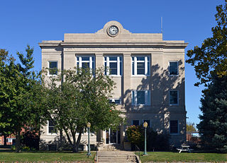
Putnam County is in north central Missouri. At the 2020 census, the population was 4,681. Its county seat is Unionville. The county was organized February 28, 1845, and named for Israel Putnam, a hero in the French and Indian War and a general in the American Revolutionary War.

<span class="mw-page-title-main">Shelby County, Iowa</span> County in Iowa, United States

Shelby County is a county located in the U.S. state of Iowa. As of the 2020 census, the population was 11,746. The county seat is Harlan. Its name is in honor of Isaac Shelby, the first Governor of Kentucky.

<span class="mw-page-title-main">Sullivan County, Missouri</span> County in Missouri, United States

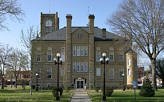
Sullivan County is a county located in the northern portion of the U.S. state of Missouri. As of the 2020 census, the population was 5,999. Its county seat is Milan. The county was organized February 14, 1845, and named for Major General John Sullivan of the American Revolutionary War.

<span class="mw-page-title-main">Schuyler County, Missouri</span> County in Missouri, United States

Schuyler County is a county located in the northeastern portion of the U.S. state of Missouri. As of the 2020 census, its population was 4,032, making it the fourth-least populous county in Missouri. Its county seat is Lancaster. The county was organized February 14, 1845, from Adair County, and named for General Philip Schuyler, delegate to the Continental Congress and U.S. Senator from New York.

<span class="mw-page-title-main">Wayne County, Iowa</span> County in Iowa, United States

Wayne County is a county located in the U.S. state of Iowa. As of the 2020 census, the population was 6,497, making it the sixth-least populous county in Iowa. The county seat is Corydon.

<span class="mw-page-title-main">Warren County, Iowa</span> County in Iowa, United States

Warren County is a county located in the U.S. state of Iowa. As of the 2020 census, the population was 52,403. The county seat is Indianola.

<span class="mw-page-title-main">Van Buren County, Iowa</span> County in Iowa, United States

Van Buren County is a county located in the U.S. state of Iowa. As of the 2020 census the population was 7,203, making it the state's tenth-least populous county. The county seat is Keosauqua, which contains the oldest continuously operational courthouse in the state of Iowa, and second oldest in the United States.

<span class="mw-page-title-main">Page County, Iowa</span> County in Iowa, United States

Page County is a county located in the U.S. state of Iowa. As of the 2020 census, the population was 15,211. The county seat is Clarinda. The county is named in honor of Captain John Page of the 4th U.S. Infantry, who was mortally wounded in the Battle of Palo Alto.

<span class="mw-page-title-main">Monroe County, Iowa</span> County in Iowa, United States

Monroe County is a county located in the south central part of the U.S. state of Iowa. In the early 20th century, it was a center of bituminous coal mining and in 1910 had a population of more than 25,000. As mining declined, people moved elsewhere for work. In the 2020 census, the population was 7,577. The county seat is Albia. The county, originally called Kishkekosh County after a famous chief of the Meskwaki, was renamed for James Monroe, fifth President of the United States.

<span class="mw-page-title-main">Fremont County, Iowa</span> County in Iowa, United States

Fremont County is a county located in the U.S. state of Iowa. As of the 2020 census the population was 6,605, making it the state's seventh-least populous county. The county seat is Sidney. The county was formed in 1847 and named for the military officer John C. Frémont.

<span class="mw-page-title-main">Decatur County, Iowa</span> County in Iowa, United States

Decatur County is a county located in the U.S. state of Iowa. As of the 2020 census, the population was 7,645. The county seat is Leon. This county is named for Stephen Decatur Jr., a hero in the War of 1812.

<span class="mw-page-title-main">Benton County, Iowa</span> County in Iowa, United States

Benton County is a county in the U.S. state of Iowa. As of the 2020 census, the population was 25,575. Its county seat and largest city is Vinton. The county is named for Thomas Hart Benton, a U.S. Senator from Missouri.

<span class="mw-page-title-main">Hancock County, Illinois</span> County in Illinois, United States

Hancock County is a county in the U.S. state of Illinois. According to the 2020 census, it has a population of 17,620. Its county seat is Carthage, and its largest city is Hamilton. The county is composed of rural towns with many farmers.

<span class="mw-page-title-main">Numa, Iowa</span> City in Iowa, USA

Numa is a city in Appanoose County, Iowa, United States. The population was 68 in the 2020 census, a decline from 109 in 2000.

<span class="mw-page-title-main">Rathbun, Iowa</span> City in Iowa, USA

Rathbun is a city in Appanoose County, Iowa, United States. The population was 43 at the time of the 2020 census.

<span class="mw-page-title-main">Udell, Iowa</span> City in Iowa, United States

Udell is a city in Appanoose County, Iowa, United States. The population was 28 at the time of the 2020 census.

<span class="mw-page-title-main">Chariton, Iowa</span> City in Iowa, USA

Chariton is a city in, and the county seat of, Lucas County, Iowa, United States. The population was 4,193 at the 2020 census. Lucas is the primary distribution center for and the former corporate headquarters of the Hy-Vee supermarket chain.

<span class="mw-page-title-main">Williamson, Iowa</span> City in Iowa, United States

Williamson is a city in Lucas County, Iowa, United States. The population was 120 at the time of the 2020 census.

<span class="mw-page-title-main">Keytesville, Missouri</span> City in Missouri, United States

Keytesville is a city in and the county seat of Chariton County, Missouri, United States. The population was 440 as of the 2020 census. Keytesville is the hometown of U.S. Army General Maxwell D. Taylor, who commanded the "Screaming Eagles" 101st Airborne division during the Normandy invasion of World War II. Confederate General Sterling Price, who attacked Keytesville during an unsuccessful cavalry raid across his home state, had previously operated a hotel there.

<span class="mw-page-title-main">Center Township, Butler County, Pennsylvania</span> Township in Pennsylvania, United States

Center Township is a township in Butler County, Pennsylvania, United States. The population was 7,900 at the 2020 census.

References

  1. 1 2 3 "2020 Census State Redistricting Data". census.gov. United states Census Bureau. Retrieved August 12, 2021.
  2. "Find a County". National Association of Counties. Archived from the original on May 31, 2011. Retrieved June 7, 2011.
  3. Appanoose County
  4. Biographical and Historical Record of Wayne and Appanoose Counties, Iowa. Chicago: Interstate Publishing Company. 1886. p. 665.
  5. "US Gazetteer files: 2010, 2000, and 1990". United States Census Bureau. February 12, 2011. Retrieved April 23, 2011.
  6. "Annual Estimates of the Resident Population for Counties: April 1, 2020 to July 1, 2023". United States Census Bureau. Retrieved April 2, 2024.
  7. "U.S. Decennial Census". United States Census Bureau. Retrieved July 13, 2014.
  8. "Historical Census Browser". University of Virginia Library. Retrieved July 13, 2014.
  9. "Population of Counties by Decennial Census: 1900 to 1990". United States Census Bureau. Retrieved July 13, 2014.
  10. "Census 2000 PHC-T-4. Ranking Tables for Counties: 1990 and 2000" (PDF). United States Census Bureau. Archived (PDF) from the original on March 27, 2010. Retrieved July 13, 2014.
  11. "State & County QuickFacts". United States Census Bureau. Archived from the original on June 7, 2011. Retrieved July 13, 2014.
  12. "Population and Housing Occupancy Status: 2010 - State County". United States Census Bureau American FactFinder. Archived from the original on September 29, 2015. Retrieved March 6, 2011.
  13. "U.S. Census website". United States Census Bureau . Retrieved January 31, 2008.
  14. Leip, David. "Dave Leip's Atlas of U.S. Presidential Elections". uselectionatlas.org. Retrieved April 25, 2018.

40°44′17″N92°52′02″W / 40.73806°N 92.86722°W / 40.73806; -92.86722