Unionville, Iowa | |
---|---|
Coordinates: 40°49′05″N92°41′45″W / 40.81806°N 92.69583°W | |
Country | United States |
State | Iowa |
County | Appanoose |
Area | |
• Total | 0.75 sq mi (1.95 km2) |
• Land | 0.75 sq mi (1.95 km2) |
• Water | 0.00 sq mi (0.00 km2) |
Elevation | 948 ft (289 m) |
Population (2020) | |
• Total | 75 |
• Density | 99.73/sq mi (38.53/km2) |
Time zone | UTC-6 (Central (CST)) |
• Summer (DST) | UTC-5 (CDT) |
ZIP code | 52594 |
Area code | 641 |
FIPS code | 19-79680 |
GNIS feature ID | 2397089 [2] |
Unionville is a city in Appanoose County, Iowa, United States. The population was 75 at the time of the 2020 census. [3]
Unionville claims to be the oldest settlement in Appanoose County; the first settles arrived in 1843 and the first school was built in 1846. [4] J. F. Stratton surveyed Unionville in 1848 on land "near the old dragoon trail, the Mormon trail". [5] Unionville was founded in 1849. [6] The city's name most likely commemorates the federal union. [7] Unionville was incorporated as a city in 1922. [8]
According to the United States Census Bureau, the city has a total area of 0.75 square miles (1.94 km2), all land. [9]
Year | Pop. | ±% |
---|---|---|
1860 | 178 | — |
1870 | 183 | +2.8% |
1880 | 196 | +7.1% |
1930 | 221 | +12.8% |
1940 | 253 | +14.5% |
1950 | 204 | −19.4% |
1960 | 185 | −9.3% |
1970 | 161 | −13.0% |
1980 | 150 | −6.8% |
1990 | 133 | −11.3% |
2000 | 127 | −4.5% |
2010 | 102 | −19.7% |
2020 | 75 | −26.5% |
Source: "U.S. Census website". United States Census Bureau . Retrieved March 29, 2020. and Iowa Data Center Source: |
As of the census [11] of 2010, there were 102 people, 49 households, and 29 families living in the city. The population density was 136.0 inhabitants per square mile (52.5/km2). There were 60 housing units at an average density of 80.0 per square mile (30.9/km2). The racial makeup of the city was 100.0% White. Hispanic or Latino of any race were 3.9% of the population.
There were 49 households, of which 26.5% had children under the age of 18 living with them, 46.9% were married couples living together, 8.2% had a female householder with no husband present, 4.1% had a male householder with no wife present, and 40.8% were non-families. 36.7% of all households were made up of individuals, and 12.3% had someone living alone who was 65 years of age or older. The average household size was 2.08 and the average family size was 2.66.
The median age in the city was 51.8 years. 17.6% of residents were under the age of 18; 7% were between the ages of 18 and 24; 18.6% were from 25 to 44; 40.2% were from 45 to 64; and 16.7% were 65 years of age or older. The gender makeup of the city was 49.0% male and 51.0% female.
As of the census [12] of 2000, there were 127 people, 50 households, and 38 families living in the city. The population density was 170.5 inhabitants per square mile (65.8/km2). There were 68 housing units at an average density of 91.3 per square mile (35.3/km2). The racial makeup of the city was 100.00% White.
There were 50 households, out of which 38.0% had children under the age of 18 living with them, 64.0% were married couples living together, 8.0% had a female householder with no husband present, and 24.0% were non-families. 24.0% of all households were made up of individuals, and 12.0% had someone living alone who was 65 years of age or older. The average household size was 2.54 and the average family size was 3.00.
In the city, the population was spread out, with 26.8% under the age of 18, 5.5% from 18 to 24, 24.4% from 25 to 44, 18.9% from 45 to 64, and 24.4% who were 65 years of age or older. The median age was 42 years. For every 100 females, there were 89.6 males. For every 100 females age 18 and over, there were 86.0 males.
The median income for a household in the city was $33,333, and the median income for a family was $44,375. Males had a median income of $26,250 versus $19,375 for females. The per capita income for the city was $13,856. There were 9.1% of families and 11.3% of the population living below the poverty line, including 22.2% of under eighteens and none of those over 64.
Putnam County is in north central Missouri. At the 2020 census, the population was 4,681. Its county seat is Unionville. The county was organized February 28, 1845, and named for Israel Putnam, a hero in the French and Indian War and a general in the American Revolutionary War.
Appanoose County is a county in the U.S. state of Iowa. As of the 2020 census, the population was 12,317. Its county seat is Centerville.
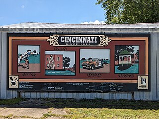
Cincinnati is a city in Appanoose County, Iowa, United States. The population was 290 in the 2020 census, a decline from 428 in 2000.
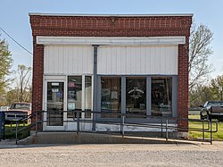
Exline is a city in Appanoose County, Iowa, United States. The population was 160 in the 2020 census, a decline from 191 in 2000.
Moravia is a city in Appanoose County, Iowa, United States. The population was 637 at the time of the 2020 census.
Moulton is a city in Appanoose County, Iowa, United States. The population was 607 at the time of the 2020 census.
Mystic is a city in Appanoose County, Iowa, United States. The population was 322 at the time of the 2020 census.
Numa is a city in Appanoose County, Iowa, United States. The population was 68 in the 2020 census, a decline from 109 in 2000.
Plano is a city in Appanoose County, Iowa, United States. The population was 59 at the time of the 2020 census.
Rathbun is a city in Appanoose County, Iowa, United States. The population was 43 at the time of the 2020 census.
Udell is a city in Appanoose County, Iowa, United States. The population was 28 at the time of the 2020 census.
Hayesville is a city in Keokuk County, Iowa, United States. The population was 41 at the time of the 2020 census.
Leighton is a city in Mahaska County, Iowa, United States. The population was 158 in the 2020 census, an increase from 153 in the 2000 census.
Macedonia is a city in Pottawattamie County, Iowa, United States. The population was 267 at the time of the 2020 census.
Dixon is a city in Scott County, Iowa, United States. The population was 202 at the time of the 2020 census.
Seymour is a city in Wayne County, Iowa, United States. The population was 634 at the time of the 2020 census.
Pomona is a city in Franklin County, Kansas, United States. As of the 2020 census, the population of the city was 884.
Unionville is a village in Tuscola County in the U.S. state of Michigan. The population was 508 at the 2010 census. The village is located in the northwestern corner of Columbia Township.
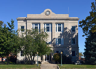
Unionville is a city in Putnam County, Missouri, United States. The population was 1,735 at the 2020 census. It is the county seat of Putnam County.
Unionville Center is a village in Union County, Ohio, in the United States. The population was 241 at the 2020 census.