
Berwick is an unincorporated community in Polk County, Iowa, United States, on the east bank of Fourmile Creek. It is part of the Des Moines–West Des Moines Metropolitan Statistical Area.
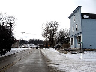
Confidence is a small unincorporated community in Wayne County, Iowa, United States. Located in south central Iowa, the community lies along County Highway J18 in the northeastern corner of its county, just west of Rathbun Lake.
Morse is an unincorporated community in Section 9, Graham Township, Johnson County, Iowa, United States. It is a part of the Iowa City Metropolitan Statistical Area.
Bladensburg is a small unincorporated community in Wapello County, Iowa, United States. It lies midway between Agency and Batavia at a distance of five miles (8 km) from each, and the largest nearby city is Ottumwa, seven miles (11 km) to the west-southwest.
Cedar is an unincorporated community in southeastern Mahaska County, Iowa, United States. It lies along Iowa Highway 23 southeast of the city of Oskaloosa, the county seat of Mahaska County.
Selma is an unincorporated community in northwestern Van Buren County, Iowa, United States. It lies along Iowa Highway 16 northwest of the city of Keosauqua, the county seat of Van Buren County. Its elevation is 617 feet (188 m).
Sperry is an unincorporated community in central Des Moines County, Iowa, United States. It lies along local roads north of the city of Burlington, the county seat of Des Moines County. Its elevation is 751 feet (229 m). Although Sperry is unincorporated, it has a post office with the ZIP code of 52650, which opened on 5 February 1870.
Killduff is an unincorporated community in southeastern Jasper County, Iowa, United States. It lies along local roads southeast of the city of Newton, the county seat of Jasper County.
Oran is an unincorporated community in southwestern Fayette County, Iowa, United States. It lies along local roads southwest of the city of West Union, the county seat of Fayette County, and west of the city of Oelwein, the largest city in Fayette County. Its elevation is 1,043 feet (318 m). Although Oran is unincorporated, it has a post office with the ZIP code of 50664.
Conroy is an unincorporated community and census-designated place (CDP) in central Iowa County, Iowa, United States. It lies along local roads southeast of the city of Marengo, the county seat of Iowa County. Its elevation is 879 feet (268 m). Conroy has a post office with the ZIP Code of 52220, which opened on 5 January 1885. As of the 2010 census the population was 259.

Austinville is an unincorporated community in southwestern Butler County, Iowa, United States. It lies along Iowa Highway 57 southwest of the city of Allison, the county seat of Butler County. Its elevation is 1,001 feet (305 m). Although Austinville is unincorporated, it has a post office with the ZIP code of 50608, which opened on 3 October 1892. In 2022, the population was 100 in town and the surrounding area.
Teeds Grove is an unincorporated community in northeastern Clinton County, Iowa, United States. It lies at the intersection of Clinton County Routes E44 and Z50, north of the city of Clinton, the county seat of Clinton County. Its elevation is 692 feet (211 m).
Pilot Grove is an unincorporated community in northern Lee County, Iowa, United States. It lies along local roads northwest of the city of Fort Madison, the county seat of Lee County. Its elevation is 643 feet (196 m).
Middleburg is an unincorporated community in Iowa, United States. Located in Sioux County, it is near Sioux Center, Boyden and Orange City.
Buchanan is an unincorporated community in Cedar County, Iowa, United States.
Cosgrove is an unincorporated community in Johnson County, Iowa, United States.
Galbraith is an unincorporated community in Kossuth County, in the U.S. state of Iowa.
Oralabor is an unincorporated community in Polk County, in the U.S. state of Iowa.
Waupeton is an unincorporated community in Dubuque County, Iowa, United States.
Zook Spur is a former unincorporated community at the border of Dallas County and Polk County, in the U.S. state of Iowa. It was at the corner of what is now NW 158th Avenue and Iowa State Highway 17.

