Winneshiek County, Iowa

Last updated

Winneshiek County
WinneshiekCourthouse.JPG
Courthouse and Civil War Monument located in Decorah
Winneshiek County Flag.jpg
Map of Iowa highlighting Winneshiek County.svg
Location within the U.S. state of Iowa
Iowa in United States.svg
Iowa's location within the U.S.
Coordinates: 43°17′00″N91°52′00″W / 43.283333333333°N 91.866666666667°W / 43.283333333333; -91.866666666667
CountryFlag of the United States.svg United States
StateFlag of Iowa.svg  Iowa
Founded1847
Named for Chief Winneshiek
Seat Decorah
Largest cityDecorah
Area
  Total690 sq mi (1,800 km2)
  Land690 sq mi (1,800 km2)
  Water0.3 sq mi (0.8 km2)  0.04%
Population
 (2020)
  Total20,070
  Density29/sq mi (11/km2)
Time zone UTC−6 (Central)
  Summer (DST) UTC−5 (CDT)
Congressional district 1st
Website winneshiekcounty.iowa.gov

Winneshiek County is a county located in the U.S. state of Iowa. As of the 2020 census, the population was 20,070. [1] The county seat is Decorah. [2]

Contents

History

A largely rural and agricultural county, Winneshiek County has a rich cultural history from Czech, Slovak, English, Irish, German, Swiss, and Norwegian immigrants that have settled within its boundaries. [3]

The county was originally settled in 1848 in present-day Bloomfield Township (near Castalia, Iowa) and in Washington Township (near Fort Atkinson, Iowa). It was organized in 1847, and named after a chief of the Winnebago tribe.

In 1980, Winneshiek County reported a population of 21,842. Like much of Iowa during the 1980s it witnessed a population loss, dropping to 20,847 according to the 1990 United States Census. However, during the 1990s the county experienced some mild growth and was able to rise above the 21,000 mark once again.

Government and elected officials

As of 2010, the Winneshiek County government had a total of 785 employees and staff.

Politics

Like all Iowa counties, Winneshiek is governed by an elected partisan Board of Supervisors. Winneshiek County's Board of Supervisors has five members elected by single-member districts of equal population. Other elected officials are the county attorney, auditor, sheriff and treasurer. The offices for the supervisors and county officers are located in the County Courthouse at the county seat.

Political culture

United States presidential election results for Winneshiek County, Iowa [4]
Year Republican Democratic Third party
No.%No.%No.%
2020 6,23551.68%5,61746.56%2121.76%
2016 5,34447.03%5,25446.24%7646.72%
2012 4,62241.70%6,25656.44%2061.86%
2008 4,27337.87%6,82960.52%1821.61%
2004 5,32449.37%5,35449.65%1060.98%
2000 4,64749.35%4,33946.08%4314.58%
1996 3,53240.27%4,12247.00%1,11612.73%
1992 3,33134.61%3,79139.39%2,50226.00%
1988 4,19448.07%4,44350.92%881.01%
1984 5,27757.96%3,72440.90%1041.14%
1980 5,03354.10%3,20134.40%1,07011.50%
1976 4,76552.08%4,15845.45%2262.47%
1972 5,87756.23%4,40142.11%1741.66%
1968 5,60060.09%3,36436.10%3553.81%
1964 3,94140.38%5,81159.55%70.07%
1960 5,73754.48%4,78645.45%70.07%
1956 6,19259.20%4,25140.64%170.16%
1952 7,15466.64%3,56033.16%220.20%
1948 4,59447.54%4,90550.76%1641.70%
1944 5,31853.76%4,55746.06%180.18%
1940 6,20853.35%5,40546.45%240.21%
1936 4,48940.15%5,98053.48%7126.37%
1932 3,34832.40%6,82366.03%1621.57%
1928 5,08452.46%4,53546.79%730.75%
1924 4,15443.96%1,51015.98%3,78640.06%
1920 6,68475.98%1,93321.97%1802.05%
1916 2,87657.87%1,95639.36%1382.78%
1912 80215.63%2,10541.03%2,22343.33%
1908 2,76756.79%2,00841.22%971.99%
1904 3,38368.96%1,46729.90%561.14%
1900 3,48664.72%1,83534.07%651.21%
1896 3,42261.75%2,03336.68%871.57%

Geography

According to the U.S. Census Bureau, the county has a total area of 690 square miles (1,800 km2), of which 690 square miles (1,800 km2) is land and 0.3 square miles (0.78 km2) (0.04%) is water. [5]

Major highways

Adjacent counties

Demographics

Historical population
CensusPop.Note
1850 546
1860 13,9422,453.5%
1870 23,57069.1%
1880 23,9381.6%
1890 22,528−5.9%
1900 23,7315.3%
1910 21,729−8.4%
1920 22,0911.7%
1930 21,630−2.1%
1940 22,2632.9%
1950 21,639−2.8%
1960 21,6510.1%
1970 21,7580.5%
1980 21,8760.5%
1990 20,847−4.7%
2000 21,3102.2%
2010 21,056−1.2%
2020 20,070−4.7%
2023 (est.)19,815 [6] −1.3%
U.S. Decennial Census [7]
1790-1960 [8] 1900-1990 [9]
1990-2000 [10] 2010-2018 [11]
Population of Winneshiek County from US census data WinneshiekCountyIowaPop2020.png
Population of Winneshiek County from US census data

2020 census

2022 US Census population pyramid for Winneshiek County from ACS 5-year estimates WinneshiekCountyIA2022PopPyr.png
2022 US Census population pyramid for Winneshiek County from ACS 5-year estimates

The 2020 census recorded a population of 20,070 in the county, with a population density of

Winneshiek County Racial Composition [12]
RaceNum.Perc.
White (NH)18,70593.2%
Black or African American (NH)1190.6%
Native American (NH)190.1%
Asian (NH)1780.9%
Pacific Islander (NH)120.06%
Other/Mixed (NH)4522.3%
Hispanic or Latino 5853%

2010 census

The 2010 census recorded a population of 21,056 in the county, with a population density of

2000 census

As of the census [14] of 2000, there were 21,310 people, 7,734 households, and 5,189 families residing in the county. The population density was 31 people per square mile (12 people/km2). There were 8,208 housing units at an average density of 12 per square mile (4.6/km2). The racial makeup of the county was 97.85% White, 0.51% Black or African American, 0.08% Native American, 0.82% Asian, 0.24% from other races, and 0.50% from two or more races. 0.80% of the population were Hispanic or Latino of any race. 38.3% were of German, 31.7% Norwegian, 5.5% Irish and 5.1% Czech ancestry.

There were 7,734 households, out of which 30.9% had children under the age of 18 living with them, 58.9% were married couples living together, 5.5% had a female householder with no husband present, and 32.9% were non-families. 27.6% of all households were made up of individuals, and 12.3% had someone living alone who was 65 years of age or older. The average household size was 2.46 and the average family size was 3.03.

In the county, the population was spread out, with 23.0% under the age of 18, 16.7% from 18 to 24, 24.2% from 25 to 44, 20.4% from 45 to 64, and 15.7% who were 65 years of age or older. The median age was 36 years. For every 100 females there were 96.8 males. For every 100 females age 18 and over, there were 94.3 males.

The median income for a household in the county was $38,908, and the median income for a family was $45,966. Males had a median income of $29,278 versus $21,240 for females. The per capita income for the county was $17,047. About 5.1% of families and 8.0% of the population were below the poverty line, including 6.5% of those under age 18 and 10.5% of those age 65 or over.

Communities

Cities

Census-designated place

Other unincorporated communities

Townships

Ghost towns

Population ranking

The population ranking of the following table is based on the 2020 census of Winneshiek County. [1]

county seat

RankCity/town/etc.Municipal typePopulation (2020 Census)
1 Decorah City7,587
2 Calmar City1,125
3 Ossian City802
4 Spillville City385
5 Fort Atkinson City312
6 Ridgeway City275
7 Burr Oak CDP171
8 Castalia City145
9 Jackson Junction City37

Education

The following school districts have their administrative headquarters in the county: [15] [16]

North Winneshiek Community School District was in the county, [17] until it merged with Decorah CSD on July 1, 2018. [18] The Decorah district and the Mabel-Canton Public Schools in Minnesota have an agreement where people who live in the Decorah district but closer to the Mabel-Canton schools than to Decorah schools can enroll in Mabel-Canton schools. [19]

The following school districts have their administrative headquarters outside of the county but serve sections of Winneshiek County: [15]

See also

Related Research Articles

<span class="mw-page-title-main">Poweshiek County, Iowa</span> County in Iowa, United States

Poweshiek County is a county in the southeastern part of the U.S. state of Iowa. As of the 2020 census, the population was 18,662. The county seat is Montezuma. The county is named for the chief of the Fox tribe who signed the treaty ending the Black Hawk War. It lies along Interstate 80 between Des Moines and Iowa City. Poweshiek County's largest city is Grinnell.

<span class="mw-page-title-main">Houston County, Minnesota</span> County in Minnesota, United States

Houston County is a county in the U.S. state of Minnesota. At the 2020 census, the population was 18,843. Its county seat is Caledonia.

<span class="mw-page-title-main">Fillmore County, Minnesota</span> County in Minnesota, United States

Fillmore County is a county in the U.S. state of Minnesota. As of the 2020 census, the population was 21,228. Its county seat is Preston. Fillmore County is included in the Rochester metropolitan area.

<span class="mw-page-title-main">Pottawattamie County, Iowa</span> County in Iowa, United States

Pottawattamie County is a county located in the U.S. state of Iowa. At the 2020 census, the population was 93,667, making it the tenth-most populous county in Iowa. The county takes its name from the Potawatomi Native American tribe. The county seat is Council Bluffs.

<span class="mw-page-title-main">Polk County, Iowa</span> County in Iowa, United States

Polk County is located in the U.S. state of Iowa. As of the 2020 census, the population was 492,401. It is Iowa's most populous county, and home to over 15% of the state's residents. The county seat is Des Moines, which is also the capital city of Iowa. Polk County is included in the Des Moines–West Des Moines, IA Metropolitan Statistical Area.

<span class="mw-page-title-main">Benton County, Iowa</span> County in Iowa, United States

Benton County is a county in the U.S. state of Iowa. As of the 2020 census, the population was 25,575. Its county seat and largest city is Vinton. The county is named for Thomas Hart Benton, a U.S. Senator from Missouri.

<span class="mw-page-title-main">Postville, Iowa</span> Village in Iowa, United States

Postville is a village in Allamakee and Clayton counties in the U.S. state of Iowa. It lies near the junction of four counties and at the intersection of U.S. Routes 18 and 52 and Iowa Highway 51, with airport facilities in the neighboring communities of Waukon, Decorah, Monona and Prairie du Chien. The population was 2,503 at the time of the 2020 census, up from 2,273 in 2000. The village is in Allamakee County's southwestern corner and the Clayton County's northwestern corner in a quad county, or four-corner region, where four counties intersect. Winneshiek County is just to the west and Fayette County just to the southwest of Postville.

<span class="mw-page-title-main">Chester, Iowa</span> City in Iowa, United States

Chester is a city in Howard County, Iowa, United States. The population was 139 in the 2020 census, a decrease of 7.9% from the 151 population in the 2000 census. Chester is located close to the state line from Minnesota.

<span class="mw-page-title-main">Colo, Iowa</span> City in Iowa, United States

Colo is a city in Story County, Iowa, United States. The population was 845 at the 2020 census. The Lincoln Highway and Jefferson Highway both pass through Colo. It is part of the Ames, Iowa Metropolitan Statistical Area, which is a part of the larger Ames-Boone, Iowa Combined Statistical Area.

<span class="mw-page-title-main">Calmar, Iowa</span> City in Iowa, United States

Calmar is a city in Winneshiek County, Iowa, United States. The population was 1,125 at the 2020 census. It is at the junction of U.S. Route 52 and State highways 150 and 24, with both state routes terminating in Calmar.

<span class="mw-page-title-main">Castalia, Iowa</span> City in Iowa, United States

Castalia is a city in Winneshiek County, Iowa, United States. The population was 145 at the 2020 census.

<span class="mw-page-title-main">Decorah, Iowa</span> City in Iowa, United States

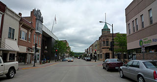
Decorah is a city in and the county seat of Winneshiek County, Iowa, United States. The population was 7,587 at the time of the 2020 census. Decorah is located at the intersection of State Highway 9 and U.S. Route 52, and is the largest community in Winneshiek County.

<span class="mw-page-title-main">Ridgeway, Iowa</span> City in Iowa, United States

Ridgeway is a city in Winneshiek County, Iowa, United States. The population was 275 at the time of the 2020 census.

<span class="mw-page-title-main">Spillville, Iowa</span> City in Iowa, United States

Spillville is a city in Winneshiek County, Iowa, United States. The population was 385 at the time of the 2020 census. It is located in Calmar Township, approximately 4 mi (6.4 km) west of Calmar and about 12 miles (19 km) southwest of Decorah, the county seat. Spillville is known for its Independence Day fireworks display, held the first Saturday in July.

<span class="mw-page-title-main">Mabel, Minnesota</span> City in Minnesota, United States

Mabel is a city in Fillmore County, Minnesota, United States. The population was 780 at the 2010 census.

<span class="mw-page-title-main">Burr Oak, Iowa</span> CDP in Iowa, United States

Burr Oak is an unincorporated community in Winneshiek County, Iowa, United States, very close to the Minnesota state line. Burr Oak is a census-designated place and the population was 166 in the 2010 census.

<span class="mw-page-title-main">Highlandville, Iowa</span> Unincorporated community in Iowa, United States

Highlandville is an unincorporated community in northeastern Winneshiek County, Iowa, United States. The community is located along local roads northeast of the city of Decorah, the county seat of Winneshiek County. The community's elevation is 945 feet (288 m).

<span class="mw-page-title-main">Decorah Community School District</span> Public school district in Decorah, Iowa, United States

The Decorah Community School District is a rural public school district located in Decorah, Iowa, United States. The district is almost entirely in Winneshiek County, with a small portion in Allamakee County. In addition to Decorah, the census-designated place of Burr Oak is in the district boundary. Other unincorporated areas in the district include Bluffton, Freeport, Hesper, Highlandville, Locust, and Nordness.

The North Winneshiek Community School District was a public school district in unincorporated northern Winneshiek County, Iowa, with a Decorah address. At the end of the district's existence, it only served grades Pre-K through 6th. The enrollment count for the 2015–2016 school year was 126 students.

Mabel-Canton Public Schools is a school district headquartered in Mabel, Minnesota. The district, which also serves Canton, has a single campus with all grades, K-12.

References

  1. 1 2 3 "2020 Census State Redistricting Data". census.gov. United states Census Bureau. Retrieved August 12, 2021.
  2. "Find a County". National Association of Counties. Retrieved June 7, 2011.
  3. Bailey, Edwin C. (1913). Past and Present of Winneshiek County, Iowa: A Record of Settlement, Organization, Progress and Achievement. Decorah Genealogy Association.
  4. Leip, David. "Dave Leip's Atlas of U.S. Presidential Elections". uselectionatlas.org. Retrieved April 28, 2018.
  5. "US Gazetteer files: 2010, 2000, and 1990". United States Census Bureau. February 12, 2011. Retrieved April 23, 2011.
  6. "Annual Estimates of the Resident Population for Counties: April 1, 2020 to July 1, 2023". United States Census Bureau. Retrieved April 2, 2024.
  7. "U.S. Decennial Census". United States Census Bureau. Retrieved July 20, 2014.
  8. "Historical Census Browser". University of Virginia Library. Retrieved July 20, 2014.
  9. "Population of Counties by Decennial Census: 1900 to 1990". United States Census Bureau. Retrieved July 20, 2014.
  10. "Census 2000 PHC-T-4. Ranking Tables for Counties: 1990 and 2000" (PDF). United States Census Bureau. Archived (PDF) from the original on March 27, 2010. Retrieved July 20, 2014.
  11. "State & County QuickFacts". United States Census Bureau. Archived from the original on June 7, 2011. Retrieved July 20, 2014.
  12. "P2 HISPANIC OR LATINO, AND NOT HISPANIC OR LATINO BY RACE – 2020: DEC Redistricting Data (PL 94-171) – Winneshiek County, Iowa".
  13. "Population & Housing Occupancy Status 2010" (PDF). United States Census Bureau American FactFinder. Archived (PDF) from the original on October 16, 2020. Retrieved August 15, 2022.
  14. "U.S. Census website". United States Census Bureau . Retrieved January 31, 2008.
  15. 1 2 "Comprehensive Plan" (PDF). Winneshiek County. December 2016. p. 90. Archived (PDF) from the original on April 6, 2020. Retrieved April 6, 2020. - (PDF p. 91/512) See "Figure 8: School Districts in Winneshiek County" in section "Public Schools"
  16. "2020 CENSUS - SCHOOL DISTRICT REFERENCE MAP: Winneshiek County, IA" (PDF). U.S. Census Bureau. Archived (PDF) from the original on July 20, 2022. Retrieved July 19, 2022. - Text list
  17. "SCHOOL DISTRICT REFERENCE MAP (2010 CENSUS): Winneshiek County, IA" (PDF). U.S. Census Bureau . Retrieved July 19, 2022. - Text list
  18. "Iowa Educational Directory 2019-2020 School Year" (PDF). Iowa Department of Education. p. 175. Archived from the original (PDF) on April 5, 2020. Retrieved April 5, 2020. (PDF p. 177/186) - From section "REORGANIZATION & DISSOLUTION ACTIONS SINCE 1965-66"
  19. "Mabel-Canton, Decorah sign enrollment agreement for students on the border". Bluff Country Newspaper Group. February 8, 2019. Retrieved April 6, 2020.

43°17′N91°52′W / 43.283°N 91.867°W / 43.283; -91.867