
Dubuque is the county seat of Dubuque County, Iowa, United States, located along the Mississippi River. In 2017, the population of Dubuque was 57,637.

Fairfield is a city in, and the county seat of, Jefferson County, Iowa, United States. It has a population totaling 9,464 people according to the 2010 census. It is a Midwestern city surrounded by rolling farmlands filled with corn, soybean, cattle, and hogs with a median family income of $46,138. The city became the county seat in 1839 with 110 residents and grew to 650 by 1847. Its library was established in 1853, and it held its first fair in 1854. Early architecture includes work by George Franklin Barber and Barry Byrne, who trained under Frank Lloyd Wright.

Cedar Rapids is the second-largest city in Iowa and is the county seat of Linn County. The city lies on both banks of the Cedar River, 20 miles (32 km) north of Iowa City and 100 miles (160 km) northeast of Des Moines, the state's capital and largest city. It is a part of the Cedar Rapids/Iowa City Corridor of Linn, Benton, Cedar, Jones, Johnson, and Washington counties.

Bettendorf is a city in Scott County, Iowa, United States. It is the fifteenth largest city of Iowa and the fourth largest city in the "Quad Cities". It is part of the Davenport–Moline–Rock Island, IA-IL Metropolitan Statistical Area. The population was 33,217 at the 2010 U.S. Census and was estimated to be 35,505 by July 2015.

Dolgeville is a village in Herkimer County and Fulton County, New York, United States. The population was 2,206 at the 2010 census. The village is named after Alfred Dolge (1848–1922), industrialist.

Pittsford is a village in Monroe County, New York, United States. The population was 1,355 at the 2010 census. It is named after Pittsford, Vermont, the native town of a founding father.

Elizabethtown-Kitley is a township in eastern Ontario, Canada, in the United Counties of Leeds and Grenville. Its southern border lies along the St. Lawrence River and it extends north into many rural hamlets and villages. The township was created on January 1, 2001 by the amalgamation of the former Township of Elizabethtown and Township of Kitley.

Hampden is a neighborhood located in northern Baltimore, Maryland, United States. Roughly triangular in shape, it is bounded to the east by the neighborhood Wyman Park to the north by Roland Park at 40th and 41st Street, to the west by the Jones Falls Expressway, and to the south by the neighborhood Remington. The Homewood campus of the Johns Hopkins University is a short distance to the east.

Ballia district is one of the districts of Uttar Pradesh, India. Ballia district is a part of Azamgarh division situated in the east of Uttar Pradesh. The main economic activity is agriculture. Ballia City is the district headquarters and commercial market of this district. There are six tehsils in this district: Ballia, Bansdih, Rasra, Bairia, Sikandarpur and Belthara. Rasra is the second major commercial area of the district, having a government sugar mill and a cotton weaving industry. Though Ballia's core occupation is agriculture there are some additional small industries. Maniar is known for its bindi industry and is a major supplier.
Orrin Williams Robinson was a politician and businessman from the U.S. state of Michigan. He ran a successful logging operation in the Upper Peninsula and was elected to serve in both houses of the Michigan Legislature and two terms as the 31st Lieutenant Governor of Michigan, from 1899 to 1903 under Governors Hazen S. Pingree and Aaron T. Bliss.

Mahabir Pun is a Nepalese teacher, social entrepreneur and an activist known for his extensive work in applying wireless technologies to develop remote areas of the Himalayas, also known as the Nepal Wireless Networking Project. He is a widely known figure in Nepal, and his work has been recognized by the Ashoka Foundation, the Ramon Magsaysay Foundation, University of Nebraska, and Global Ideas Bank. He is a humanitarian whose work is inspiring many youths to return their own country and serve it for its development. Mahabir Pun is a person with phenomenal qualities, he is always ready to eradicate different problems inside the country.

The Postville Herald is the official newspaper of Postville, Iowa. It is also one of two official newspapers of Allamakee . Seated at the hub of the four counties of Allamakee, Clayton, Winneshiek and Fayette, the Herald covers news and events in the four-county region.

St. Katherine's Historic District is located on the east side Davenport, Iowa, United States and is listed on the National Register of Historic Places. It is the location of two mansions built by two lumber barons until it became the campus of an Episcopal girls' school named St. Katharine's Hall and later as St. Katharine's School. The name was altered to St. Katharine-St. Mark's School when it became coeducational. It is currently the location of a senior living facility called St. Katherine's Living Center.
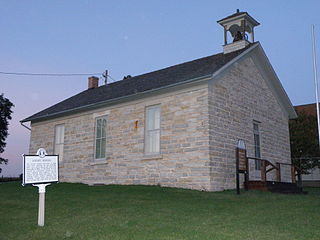
Locust School is a historic building located north of Decorah, Iowa, United States. Built in 1854, the one-room schoolhouse is composed of rubble ashlar limestone and capped with a gable roof. The lintels and window sills are also stone. A belfry with round-arch openings is located above the main entrance. The school was established just after the village of Locust was surveyed and settlement had begun. It remained in operation with all elementary grades until 1950, when it was reduced to specific grades. It was closed in 1960. The Winneshiek County Historical Society acquired the building and operates a museum in it. It was one of the first school buildings constructed in Winneshiek County. The building was listed on the National Register of Historic Places in 1978.

The Burr Oak House/Masters Hotel, also known as the Laura Ingalls Wilder Museum and Park, is a historic building located in Burr Oak, Iowa, United States. The 1½-story frame structure was built in 1856, and features a full width front porch and a raised basement. Its significance is derived from three elements of its history. First, it is one of the few pre-1860 buildings that was built specifically as a hotel that remains in Iowa. Second, it served as a hotel in a small Iowa town for a significant period of time, enduring changing economic times and tastes. The hotel started as a log structure that was built in 1851, and after this building was built five years later, remained in business until 1878 with different owners and names. At that time it became a dry goods and general store, and served that purpose into the early 1890s when Dr. W.H. Emmons used it as a residence and office. Around 1896 a two-story addition, no longer extant, was built onto the south side and it was made exclusively into a house.

Birdsall Lime Kiln is a historic structure located northeast of Decorah, Iowa, United States. Built in 1877, the kiln is 24 feet (7 m) high, and composed of irregularly-cut undressed limestone and exterior wood bracing. Its inside walls are lined with locally produced firebrick. The lime was produced from abundant native limestone. It was used in mortar for masonry construction, and by the Winneshiek Paper Company of Freeport, Iowa in its paper-making processes. The structure was listed on the National Register of Historic Places in 1979.

The Cooley-Whitney House is a historic house located at 305 Grove Street in Decorah, Iowa.
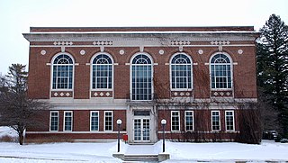
Koren Hall, formerly known as Koren Library, is located on the campus of Luther College in Decorah, Iowa, United States. Completed in 1921, it served as the college's library until 1969 when Preus Library opened. Koren Hall was officially dedicated on October 14, 1921. The building is named for Ulrik Vilhelm Koren, one of the college's founders and a long-time supporter. From 1969 to 1978 it housed the Spiritual Life Center as well as offices and classrooms. The former reading room was converted into a chapel. The building now houses classrooms and offices for the social sciences, the Anthropology Lab, and the Anthropology Collections. The two to three story brick building was designed in the Neoclassical style by the Minneapolis architectural firm of Magney & Tusler. It was listed on the National Register of Historic Places in 1984.
East Mills Community School District or East Mills Schools is a school district headquartered in Hastings, Iowa. The district is mostly in Mills County, with small portions in Montgomery County. It serves the communities of Hastings, Emerson, Henderson, and Malvern.


