Jackson Junction, Iowa

Last updated

Jackson Junction, Iowa
Winneshiek County Iowa Incorporated and Unincorporated areas Jackson Junction Highlighted.svg
Location of Jackson Junction, Iowa
Coordinates: 43°6′25″N92°2′48″W / 43.10694°N 92.04667°W / 43.10694; -92.04667
Country Flag of the United States.svg  United States
State Flag of Iowa.svg  Iowa
County Winneshiek
Area
[1]
  Total5.96 sq mi (15.43 km2)
  Land5.96 sq mi (15.43 km2)
  Water0.00 sq mi (0.00 km2)
Elevation
1,158 ft (353 m)
Population
 (2020)
  Total37
  Density6.21/sq mi (2.40/km2)
Time zone UTC-6 (Central (CST))
  Summer (DST) UTC-5 (CDT)
ZIP code
52171
FIPS code 19-39135
GNIS feature ID0457893

Jackson Junction is a city in Winneshiek County, Iowa, United States. The population was 37 at the time of the 2020 census. [2]

Contents

Geography

Jackson Junction is located at 43°6′25″N92°2′48″W / 43.10694°N 92.04667°W / 43.10694; -92.04667 (43.106913, -92.046724). [3]

According to the United States Census Bureau, the city has a total area of 5.99 square miles (15.51 km2), all land. [4]

Demographics

Historical populations
YearPop.±%
1900 171    
1910 160−6.4%
1920 130−18.8%
1930 126−3.1%
1940 122−3.2%
1950 107−12.3%
1960 89−16.8%
1970 106+19.1%
1980 94−11.3%
1990 87−7.4%
2000 60−31.0%
2010 58−3.3%
2020 37−36.2%
Source: "U.S. Census website". United States Census Bureau . Retrieved March 29, 2020. and Iowa Data Center
Source:
U.S. Decennial Census [5] [2]

2010 census

As of the census [6] of 2010, there were 58 people, 21 households, and 18 families living in the city. The population density was 9.7 inhabitants per square mile (3.7/km2). There were 23 housing units at an average density of 3.8 per square mile (1.5/km2). The racial makeup of the city was 98.3% White and 1.7% Asian.

There were 21 households, of which 38.1% had children under the age of 18 living with them, 66.7% were married couples living together, 14.3% had a female householder with no husband present, 4.8% had a male householder with no wife present, and 14.3% were non-families. 14.3% of all households were made up of individuals, and 9.6% had someone living alone who was 65 years of age or older. The average household size was 2.76 and the average family size was 3.00.

The median age in the city was 37.5 years. 25.9% of residents were under the age of 18; 5.1% were between the ages of 18 and 24; 27.6% were from 25 to 44; 27.5% were from 45 to 64; and 13.8% were 65 years of age or older. The gender makeup of the city was 56.9% male and 43.1% female.

2000 census

As of the census [7] of 2000, there were 60 people, 24 households, and 15 families living in the city. The population density was 10.0 inhabitants per square mile (3.9/km2). There were 24 housing units at an average density of 4.0 per square mile (1.5/km2). The racial makeup of the city was 98.33% White and 1.67% Asian.

There were 24 households, out of which 29.2% had children under the age of 18 living with them, 58.3% were married couples living together, 4.2% had a female householder with no husband present, and 37.5% were non-families. 37.5% of all households were made up of individuals, and 8.3% had someone living alone who was 65 years of age or older. The average household size was 2.50 and the average family size was 3.40.

In the city, the population was spread out, with 30.0% under the age of 18, 3.3% from 18 to 24, 33.3% from 25 to 44, 25.0% from 45 to 64, and 8.3% who were 65 years of age or older. The median age was 38 years. For every 100 females, there were 122.2 males. For every 100 females age 18 and over, there were 133.3 males.

The median income for a household in the city was $31,875, and the median income for a family was $41,563. Males had a median income of $31,042 versus $13,750 for females. The per capita income for the city was $15,825. There were no families and 4.4% of the population living below the poverty line, including no under eighteens and none of those over 64.

Education

The municipality is within the Turkey Valley Community School District. [8] The district, which also serves the nearby communities of Waucoma; Lawler; Fort Atkinson; St. Lucas and Protivin as well as its rural areas, maintains its school in Jackson Junction.

Related Research Articles

<span class="mw-page-title-main">Sumiton, Alabama</span> City in Alabama, United States

Sumiton is a city in Jefferson and Walker counties in the State of Alabama. It incorporated in 1952. At the 2010 census the population was 2,520, down from 2,665 in 2000.

<span class="mw-page-title-main">Junction City, Arkansas</span> City in Arkansas, United States

Junction City is a city in Union County, Arkansas, United States, and is the twin city of neighboring Junction City, Louisiana. The population was 581 at the 2010 census.

<span class="mw-page-title-main">Maunie, Illinois</span> Village in Illinois, United States

Maunie is a village in White County, Illinois, United States. The population was 177 at the 2000 census.

<span class="mw-page-title-main">Oxford Junction, Iowa</span> City in Iowa, United States

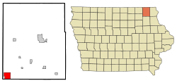
Oxford Junction is a city in Jones County, Iowa, United States. The population was 424 at the time of the 2020 census. It is part of the Cedar Rapids Metropolitan Statistical Area.

<span class="mw-page-title-main">Duplain Township, Michigan</span> Civil township in Michigan, United States

Duplain Township is a civil township of Clinton County in the U.S. state of Michigan. The population was 2,363 at the 2010 census.

<span class="mw-page-title-main">Biscay, Minnesota</span> City in Minnesota, United States

Biscay is a city in McLeod County, Minnesota, United States. The population was 113 at the 2010 census.

<span class="mw-page-title-main">Vergas, Minnesota</span> City in Minnesota, United States

Vergas is a city in northern Otter Tail County, Minnesota, United States. The population was 348 at the 2020 census.

<span class="mw-page-title-main">Iron Junction, Minnesota</span> City in Minnesota, United States

Iron Junction is a city in Saint Louis County, Minnesota, United States. The population was 86 at the 2010 census.

<span class="mw-page-title-main">Carl Junction, Missouri</span> City in Missouri, United States

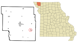
Carl Junction is a city in Jasper County, Missouri, United States. The population was 8,143 at the 2020 census.

<span class="mw-page-title-main">Junction City, Missouri</span> Village in Missouri, United States

Junction City is a village in Madison County, Missouri, United States. The population was 327 at the 2010 census.

<span class="mw-page-title-main">Conception Junction, Missouri</span> City in Missouri, United States

Conception Junction is a city in Nodaway County, Missouri, United States, near the Platte River. The population was 198 at the 2010 census, at which time it was a town.

<span class="mw-page-title-main">Clintondale, New York</span> CDP in New York, United States

Clintondale is a hamlet in Ulster County, New York, United States. The population was 1,938 at the 2020 census.

<span class="mw-page-title-main">Kramer, North Dakota</span> City in North Dakota, United States

Kramer is a city in Bottineau County, North Dakota, United States. The population was 24 at the 2020 census. Kramer was founded in 1905.

<span class="mw-page-title-main">Cogswell, North Dakota</span> City in North Dakota, United States

Cogswell is a city in Sargent County, North Dakota, United States. The population was 73 at the 2020 census. Cogswell was founded in 1890.

<span class="mw-page-title-main">Junction City, Ohio</span> Village in Ohio, United States

Junction City is a village in Perry County, Ohio, United States. The population was 721 at the 2020 census.

<span class="mw-page-title-main">Hamlin, West Virginia</span> Town in West Virginia, United States

Hamlin is a town in and the county seat of Lincoln County, West Virginia, United States, along the Mud River. The population was recorded as 1,040 at the 2020 census. It is part of the Huntington–Ashland metropolitan area.

<span class="mw-page-title-main">Downing, Wisconsin</span> Village in Wisconsin, United States

Downing is a village in Dunn County, Wisconsin, United States. Bordering St. Croix County to the west, the village is otherwise surrounded by the Town of Tiffany. The population was 234 at the 2020 census.

<span class="mw-page-title-main">Smyrna, South Carolina</span> Town in South Carolina, United States

Smyrna is a small town in York and Cherokee counties in the U.S. state of South Carolina. The population was 45 at the 2010 United States Census,..

<span class="mw-page-title-main">Winchendon (CDP), Massachusetts</span> Census-designated place in Massachusetts, United States

Winchendon is a census-designated place (CDP) in the town of Winchendon in Worcester County, Massachusetts, United States. The population was 4,213 at the 2010 census.

Highland is a town in Iowa County, Wisconsin, United States. The population was 797 at the 2000 census. The village of Highland is located within the town.

References

  1. "2020 U.S. Gazetteer Files". United States Census Bureau. Retrieved March 16, 2022.
  2. 1 2 "2020 Census State Redistricting Data". census.gov. United states Census Bureau. Retrieved August 12, 2021.
  3. "US Gazetteer files: 2010, 2000, and 1990". United States Census Bureau. February 12, 2011. Retrieved April 23, 2011.
  4. "US Gazetteer files 2010". United States Census Bureau. Archived from the original on January 12, 2012. Retrieved May 11, 2012.
  5. "Census of Population and Housing". Census.gov. Retrieved June 4, 2015.
  6. "U.S. Census website". United States Census Bureau . Retrieved May 11, 2012.
  7. "U.S. Census website". United States Census Bureau . Retrieved January 31, 2008.
  8. "Turkey Valley" (PDF). Iowa Department of Education . Retrieved April 6, 2020.