Page County, Iowa

Last updated

Page County
Clarinda2.jpg
The courthouse in Clarinda is on the NRHP.
Map of Iowa highlighting Page County.svg
Location within the U.S. state of Iowa
Iowa in United States.svg
Iowa's location within the U.S.
Coordinates: 40°44′17″N95°08′53″W / 40.738055555556°N 95.148055555556°W / 40.738055555556; -95.148055555556
CountryFlag of the United States.svg United States
StateFlag of Iowa.svg  Iowa
FoundedFebruary 24, 1847
Named for John Page
Seat Clarinda
Largest cityClarinda
Area
  Total535 sq mi (1,390 km2)
  Land535 sq mi (1,390 km2)
  Water0.5 sq mi (1 km2)  0.1%
Population
 (2020)
  Total15,211
  Density28/sq mi (11/km2)
Time zone UTC−6 (Central)
  Summer (DST) UTC−5 (CDT)
Congressional district 3rd
Website pagecounty.iowa.gov

Page County is a county located in the U.S. state of Iowa. As of the 2020 census, the population was 15,211. [1] The county seat is Clarinda. [2] The county is named in honor of Captain John Page of the 4th U.S. Infantry, who was mortally wounded in the Battle of Palo Alto.

Contents

Geography

According to the U.S. Census Bureau, the county has a total area of 535 square miles (1,390 km2), of which 535 square miles (1,390 km2) is land and 0.5 square miles (1.3 km2) (0.1%) is water. [3]

Major highways

Transit

Adjacent counties

Demographics

Historical population
CensusPop.Note
1850 551
1860 4,419702.0%
1870 9,975125.7%
1880 19,66797.2%
1890 21,3418.5%
1900 24,18713.3%
1910 24,002−0.8%
1920 24,1370.6%
1930 25,9047.3%
1940 24,887−3.9%
1950 23,921−3.9%
1960 21,023−12.1%
1970 18,537−11.8%
1980 19,0632.8%
1990 16,870−11.5%
2000 16,9760.6%
2010 15,932−6.1%
2020 15,211−4.5%
2023 (est.)15,014 [4] −1.3%
U.S. Decennial Census [5]
1790-1960 [6] 1900-1990 [7]
1990-2000 [8] 2010-2018 [9]
Population of Page County from US census data PageCountyIowaPop2020.png
Population of Page County from US census data

2020 census

2022 US Census population pyramid for Page County from ACS 5-year estimates PageCountyIA2022PopPyr.png
2022 US Census population pyramid for Page County from ACS 5-year estimates

The 2020 census recorded a population of 15,211 in the county, with a population density of

Page County Racial Composition [10]
RaceNum.Perc.
White (NH)13,68690%
Black or African American (NH)3652.4%
Native American (NH)600.4%
Asian (NH)1170.8%
Pacific Islander (NH)00%
Other/Mixed (NH)5193.41%
Hispanic or Latino 4643.1%

2010 census

The 2010 census recorded a population of 15,932 in the county, with a population density of

2000 census

At the 2000 census there were 16,976 people, 6,708 households, and 4,460 families in the county. The population density was 32 people per square mile (12 people/km2). There were 7,302 housing units at an average density of 14 units per square mile (5.4 units/km2). The racial makeup of the county was 96.11% White, 1.66% Black or African American, 0.49% Native American, 0.48% Asian, 0.01% Pacific Islander, 0.49% from other races, and 0.77% from two or more races. 1.56%. [12] were Hispanic or Latino of any race.

Of the 6,708 households 28.20% had children under the age of 18 living with them, 55.50% were married couples living together, 8.10% had a female householder with no husband present, and 33.50% were non-families. 29.90% of households were one person and 15.40% were one person aged 65 or older. The average household size was 2.32 and the average family size was 2.87.

The age distribution was 23.30% under the age of 18, 7.90% from 18 to 24, 26.30% from 25 to 44, 22.80% from 45 to 64, and 19.80% 65 or older. The median age was 40 years. For every 100 females there were 102.70 males. For every 100 females age 18 and over, there were 101.80 males.

The median household income was $35,466 and the median family income was $42,446. Males had a median income of $32,549 versus $21,526 for females. The per capita income for the county was $16,670. About 8.10% of families and 12.50% of the population were below the poverty line, including 17.90% of those under age 18 and 7.60% of those age 65 or over.

Communities

Cities

Townships

Population ranking

The population ranking of the following table is based on the 2020 census of Page County. [1]

county seat

RankCity/Town/etc.Municipal typePopulation (2020 Census)
1 Clarinda City5,369
2 Shenandoah (partially in Fremont County )City4,925 (4,925 total)
3 Essex City722
4 Coin City176
5 College Springs City172
6 Shambaugh City159
7 Braddyville City147
8 Yorktown City60
9 Northboro City52
10 Blanchard City29
11 Hepburn City26

History

A fire on December 11, 1991, heavily damaged the Page County Courthouse. The fire was believed to have started in the attic and spread throughout much of the building. Multiple area fire departments fought the blaze and saved the structure. Court services were relocated to several buildings in Clarinda and other areas of Page County as repairs were made to the courthouse. After 2+12 years of work, the courthouse was re-occupied in March 1994. [13] [14]

Politics

Just like Cass County, Iowa , Page County has long been a Republican stronghold going back generations. Franklin D. Roosevelt in his 1932 landslide was the only Democrat to win the county post-Civil War, and even he couldn't hold onto the county 4 years later despite winning in an even bigger landslide.

United States presidential election results for Page County, Iowa [15]
Year Republican Democratic Third party
No.%No.%No.%
2020 5,31970.66%2,08627.71%1231.63%
2016 4,89369.46%1,80725.65%3444.88%
2012 4,34861.42%2,61336.91%1181.67%
2008 4,35159.12%2,90039.41%1081.47%
2004 5,24369.79%2,21129.43%590.79%
2000 4,58865.00%2,29332.48%1782.52%
1996 4,03257.25%2,22031.52%79111.23%
1992 3,67050.21%1,95126.69%1,68923.11%
1988 4,58367.37%2,18532.12%350.51%
1984 5,87675.06%1,91424.45%380.49%
1980 5,61871.93%1,77222.69%4205.38%
1976 5,34364.10%2,86534.37%1271.52%
1972 6,20076.43%1,79022.07%1221.50%
1968 5,90768.06%2,12824.52%6447.42%
1964 4,77551.85%4,40247.80%320.35%
1960 7,08969.69%3,07530.23%80.08%
1956 7,38070.98%3,00128.86%160.15%
1952 8,84076.52%2,66923.10%440.38%
1948 5,63860.15%3,56738.05%1691.80%
1944 6,30065.07%3,29734.05%850.88%
1940 7,40764.04%4,10235.47%570.49%
1936 6,62458.50%4,64641.03%530.47%
1932 4,51247.46%4,86351.15%1321.39%
1928 7,18173.34%2,47825.31%1331.36%
1924 6,02365.58%1,64317.89%1,51816.53%
1920 6,94976.10%1,93121.15%2512.75%
1916 2,99360.87%1,74735.53%1773.60%
1912 98019.65%1,46229.32%2,54551.03%
1908 3,14160.77%1,72633.39%3025.84%
1904 3,46371.21%94419.41%4569.38%
1900 3,42460.68%1,88933.48%3305.85%
1896 3,21356.32%2,39041.89%1021.79%

See also

Related Research Articles

<span class="mw-page-title-main">Adams County, Iowa</span> County in Iowa, United States

Adams County is a county in the U.S. state of Iowa. As of the 2020 census, the population was 3,704, making it Iowa's least-populous county. Its county seat is Corning.

<span class="mw-page-title-main">Warren County, Iowa</span> County in Iowa, United States

Warren County is a county located in the U.S. state of Iowa. As of the 2020 census, the population was 52,403. The county seat is Indianola.

<span class="mw-page-title-main">Taylor County, Iowa</span> County in Iowa, United States

Taylor County is a county located in the U.S. state of Iowa. As of the 2020 census, the population was 5,896, making it the fourth-least populous county in Iowa. The county seat is Bedford. The county was formed in 1847 and named after General and President Zachary Taylor.

<span class="mw-page-title-main">Ringgold County, Iowa</span> County in Iowa, United States

Ringgold County is a county located in the U.S. state of Iowa. As of the 2020 census, the population was 4,663, making it the Iowa county with the second-smallest population. The county seat is Mount Ayr. The county is named after Maj. Samuel Ringgold, a hero of the Battle of Palo Alto fought in May 1846, during the Mexican–American War. It is one of the 26 Iowa counties with a name that is unique across the nation.

<span class="mw-page-title-main">Decatur County, Iowa</span> County in Iowa, United States

Decatur County is a county located in the U.S. state of Iowa. As of the 2020 census, the population was 7,645. The county seat is Leon. This county is named for Stephen Decatur Jr., a hero in the War of 1812.

<span class="mw-page-title-main">Audubon County, Iowa</span> County in Iowa, United States

Audubon County is a county in the U.S. state of Iowa. As of the 2020 census, the population was 5,674, making it Iowa's third-least populous county. Its county seat is Audubon. The county was named after John James Audubon, the naturalist and artist.

<span class="mw-page-title-main">Appanoose County, Iowa</span> County in Iowa, United States

Appanoose County is a county in the U.S. state of Iowa. As of the 2020 census, the population was 12,317. Its county seat is Centerville.

<span class="mw-page-title-main">Adair County, Iowa</span> County in Iowa, United States

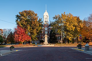
Adair County is a county in the U.S. state of Iowa. As of the 2020 census, the population was 7,496. Its county seat is Greenfield.

<span class="mw-page-title-main">Bridgewater, Iowa</span> City in Iowa, United States

Bridgewater is a city in Jackson Township, Adair County, Iowa, United States. The population was 148 at the time of the 2020 census. Bridgewater was founded in 1885.

<span class="mw-page-title-main">Fontanelle, Iowa</span> City in Iowa, United States

Fontanelle is a city in Summerset Township, Adair County, Iowa, United States. The population was 676 at the time of the 2020 census.

<span class="mw-page-title-main">Nodaway, Iowa</span> City in Iowa, United States

Nodaway is a city in Nodaway Township, Adams County, Iowa, United States. The population was 74 at the time of the 2020 census. Nodaway was incorporated in 1900.

<span class="mw-page-title-main">Dakota City, Iowa</span> City in Iowa, United States

Dakota City is a city in and the county seat of Humboldt County, Iowa, United States. The population was 759 at the time of the 2020 census. Dakota City shares its western border with the much larger city of Humboldt. It is the least populous county seat in Iowa.

<span class="mw-page-title-main">Braddyville, Iowa</span> City in Iowa, United States

Braddyville is a city in Page County, Iowa, United States. The population was 147 at the 2020 census.

<span class="mw-page-title-main">Clarinda, Iowa</span> City in Iowa, United States

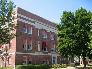
Clarinda is a city in and the county seat of Page County, Iowa. It is located in Nodaway Township. The population was 5,369 at the time of the 2020 census.

<span class="mw-page-title-main">Hepburn, Iowa</span> City in Iowa, United States

Hepburn is a city in Page County, Iowa, United States. The population was 26 at the time of the 2020 census.

<span class="mw-page-title-main">Shambaugh, Iowa</span> City in Iowa, United States

Shambaugh is a city in Page County, Iowa, United States. The population was 159 at the time of the 2020 census.

<span class="mw-page-title-main">Burlington Junction, Missouri</span> City in Missouri, United States

Burlington Junction is a city in Nodaway County, Missouri, United States. The population was 521 at the 2020 census.

<span class="mw-page-title-main">Clearmont, Missouri</span> City in Missouri, United States

Clearmont is a city in northwest Nodaway County, Missouri, United States. The population was 158 at the 2020 census.

<span class="mw-page-title-main">Parnell, Missouri</span> City in Missouri, United States

Parnell is a city in northeast Nodaway County, Missouri, United States, near the Platte River. The population was 191 at the 2010 Census. It was home to the father-son horse trainers Ben and Jimmy Jones, whose horses won eight Kentucky Derbies and two Triple Crowns.

<span class="mw-page-title-main">King Township, Bedford County, Pennsylvania</span> Township in Pennsylvania, United States

King Township is a township that is located in Bedford County, Pennsylvania, United States. The population was 1,179 at the time of the 2020 census.

References

  1. 1 2 3 "2020 Census State Redistricting Data". census.gov. United states Census Bureau. Retrieved August 12, 2021.
  2. "Find a County". National Association of Counties. Retrieved June 7, 2011.
  3. "US Gazetteer files: 2010, 2000, and 1990". United States Census Bureau. February 12, 2011. Retrieved April 23, 2011.
  4. "Annual Estimates of the Resident Population for Counties: April 1, 2020 to July 1, 2023". United States Census Bureau. Retrieved April 2, 2024.
  5. "U.S. Decennial Census". United States Census Bureau. Retrieved July 20, 2014.
  6. "Historical Census Browser". University of Virginia Library. Retrieved July 20, 2014.
  7. "Population of Counties by Decennial Census: 1900 to 1990". United States Census Bureau. Retrieved July 20, 2014.
  8. "Census 2000 PHC-T-4. Ranking Tables for Counties: 1990 and 2000" (PDF). United States Census Bureau. Archived (PDF) from the original on March 27, 2010. Retrieved July 20, 2014.
  9. "State & County QuickFacts". United States Census Bureau. Archived from the original on June 7, 2011. Retrieved July 20, 2014.
  10. "P2 HISPANIC OR LATINO, AND NOT HISPANIC OR LATINO BY RACE – 2020: DEC Redistricting Data (PL 94-171) – Page County, Iowa".
  11. "Population & Housing Occupancy Status 2010" (PDF). United States Census Bureau American FactFinder. Archived (PDF) from the original on October 16, 2020. Retrieved May 22, 2011.
  12. "U.S. Census website". United States Census Bureau . Retrieved January 31, 2008.
  13. Dinnebier, Kent, "Clarinda recalls courthouse fire 30 years later", Herald-Journal, December 7, 2001. Retrieved October 12, 2021.
  14. Petersen, Mike, "'The Night the Courthouse Burned' – Part I," KMA radio, December 8, 2021. (First in a three-part series about the fire, its impact on the community and efforts to rebuild.) Retrieved October 12, 2021.
  15. Leip, David. "Dave Leip's Atlas of U.S. Presidential Elections". uselectionatlas.org. Retrieved April 27, 2018.

40°44′17″N95°08′53″W / 40.73806°N 95.14806°W / 40.73806; -95.14806