Dallas County, Iowa

Last updated

Dallas County
Dallas County Courthouse.jpg
Map of Iowa highlighting Dallas County.svg
Location within the U.S. state of Iowa
Iowa in United States.svg
Iowa's location within the U.S.
Coordinates: 41°40′58″N94°02′06″W / 41.682777777778°N 94.035°W / 41.682777777778; -94.035
CountryFlag of the United States.svg United States
StateFlag of Iowa.svg  Iowa
FoundedJanuary 13, 1846
Named for George M. Dallas
Seat Adel
Largest city Waukee
Area
  Total592 sq mi (1,530 km2)
  Land588 sq mi (1,520 km2)
  Water3.3 sq mi (9 km2)  0.5%
Population
 (2020)
  Total99,678
  Density170/sq mi (65/km2)
Time zone UTC−6 (Central)
  Summer (DST) UTC−5 (CDT)
Congressional district 3rd
Website www.dallascountyiowa.gov

Dallas County is a county located in the U.S. state of Iowa. As of the 2020 Census, the population was 99,678, making it the seventh-most populous county in Iowa. Between 2010 and 2020, it was the fastest growing county in Iowa and one of the fastest growing in the country. [1] Its county seat is Adel, [2] and its largest city is Waukee. The county was named for George M. Dallas, Vice President of the United States under James K. Polk, the namesake of neighboring Polk County.

Contents

Dallas County is included in the Des MoinesWest Des Moines, IA Metropolitan Statistical Area. [3]

History

The land that now forms Dallas County was ceded by the Sac and Fox nation to the United States in a treaty signed on October 11, 1842.

On January 13, 1846, the legislative body of the Iowa Territory authorized the creation of twelve counties in the Iowa Territory, [4] with general descriptions of their boundaries. [5] Dallas County's name referred to United States Vice President George M. Dallas, who served from 1845 to 1849.

In 1847 the county residents voted to designate Penoch as the county seat (the name was changed to Adel in 1849). The county's population grew rapidly, with settlers coming to claim homesteads. By 1870, the population had crossed the 12,000 mark.

Geography

According to the United States Census Bureau, the county has a total area of 592 square miles (1,530 km2), of which 588 square miles (1,520 km2) is land and 3.3 square miles (8.5 km2) (0.5%) is water. [6]

Major highways

Adjacent counties

Demographics

Historical population
CensusPop.Note
1850 854
1860 5,244514.1%
1870 12,019129.2%
1880 18,74656.0%
1890 20,4799.2%
1900 23,05812.6%
1910 23,6282.5%
1920 25,1206.3%
1930 25,4931.5%
1940 24,649−3.3%
1950 23,661−4.0%
1960 24,1232.0%
1970 26,0858.1%
1980 29,51313.1%
1990 29,7550.8%
2000 40,75037.0%
2010 66,13562.3%
2020 99,67850.7%
2023 (est.)111,092 [8] 11.5%
U.S. Decennial Census [9]
1790-1960 [10] 1900-1990 [11]
1990-2000 [12] 2010-2018 [13]
Population of Dallas County from US census data DallasCountyIowaPop2020.png
Population of Dallas County from US census data

2020 census

2022 US Census population pyramid for Dallas County from ACS 5-year estimates DallasCountyIA2022PopPyr.png
2022 US Census population pyramid for Dallas County from ACS 5-year estimates

The 2020 census recorded a population of 99,678 in the county, with a population density of

Dallas County Racial Composition [14]
RaceNum.Perc.
White (NH)81,70882%
Black or African American (NH)2,6572.7%
Native American (NH)1370.14%
Asian (NH)4,9875%
Pacific Islander (NH)320.03%
Other/Mixed (NH)3,6423.7%
Hispanic or Latino 6,5156.54%

2010 census

The 2010 census recorded a population of 66,135 in the county, with a population density of

2000 census

As of the census [16] of 2000, there were 40,750 people, 15,584 households, and 11,173 families in the county. The population density was 70 inhabitants per square mile (27/km2). There were 16,529 housing units at an average density of 28 per square mile (11/km2). The racial makeup of the county was 94.75% White, 0.74% Black or African American, 0.15% Native American, 0.69% Asian, 0.04% Pacific Islander, 2.79% from other races, and 0.84% from two or more races. 5.40% of the population were Hispanic or Latino of any race.

Of the 15,584 households, 37.20% had children under the age of 18 living with them, 60.60% were married couples living together, 8.00% had a female householder with no husband present, and 28.30% were non-families. 23.60% of households were one person and 8.20% were one person aged 65 or older. The average household size was 2.59 and the average family size was 3.08.

The age distribution was 28.20% under the age of 18, 6.90% from 18 to 24, 32.10% from 25 to 44, 21.60% from 45 to 64, and 11.10% 65 or older. The median age was 35 years. For every 100 females, there were 97.70 males. For every 100 females age 18 and over, there were 93.80 males.

The median household income was $48,528 and the median family income was $58,293. Males had a median income of $37,243 versus $27,026 for females. The per capita income for the county was $22,970. About 4.00% of families and 5.60% of the population were below the poverty line, including 6.10% of those under age 18 and 7.10% of those age 65 or over.

Communities

Cities

‡ partly in Polk County

Unincorporated communities

Townships

Population ranking

The population ranking of the following table is based on the 2020 census of Dallas County. [1]

county seat

RankCity/Town/etc.Municipal typePopulation (2020 Census)
1 West Des Moines (mostly in Polk County )City68,723
2 Urbandale (partially in Polk County)City45,580
3 Waukee City23,940
4 Clive (partially in Polk County)City18,601
5 Grimes (mostly in Polk County)City15,392
6 Perry City7,836
7 Adel City6,153
8 Dallas Center City1,901
9 Granger (partially in Polk County)City1,654
10 Van Meter City1,484
11 Woodward City1,346
12 De Soto City915
13 Redfield City731
14 Dexter City640
15 Minburn City325
16 Linden City200
17 Dawson City116
18 Bouton City127

Politics

Prior to 1932, Dallas County was strongly Republican in presidential elections. From 1932 to 1996, it was a swing county, having a Republican lean until 1960 & a Democratic lean from 1964 to 1996, especially after 1980. Since 2000, it has been consistently Republican, though no Republican presidential candidate has won over 58% of the vote nor has a Democrat won less than 41% since then.

United States presidential election results for Dallas County, Iowa [17]
Year Republican Democratic Third party
No.%No.%No.%
2020 27,98749.96%26,87947.98%1,1562.06%
2016 19,33950.56%15,70141.05%3,2128.40%
2012 20,98855.06%16,57643.49%5521.45%
2008 16,95451.94%15,14946.41%5401.65%
2004 15,18357.75%10,91741.52%1930.73%
2000 10,30653.32%8,56144.29%4632.40%
1996 6,64741.52%8,01750.07%1,3468.41%
1992 5,58737.60%6,55444.10%2,72018.30%
1988 4,85839.12%7,50160.40%600.48%
1984 6,08047.85%6,56451.66%630.50%
1980 6,29648.57%5,31040.96%1,35810.48%
1976 5,30843.34%6,72254.89%2171.77%
1972 6,14353.72%5,08544.46%2081.82%
1968 5,54949.16%5,06244.85%6765.99%
1964 3,76333.41%7,44766.13%520.46%
1960 6,56653.93%5,59745.97%130.11%
1956 6,61956.06%5,18543.92%20.02%
1952 8,00863.51%4,50135.69%1010.80%
1948 4,81044.46%5,66152.32%3483.22%
1944 5,41349.83%5,31648.93%1351.24%
1940 6,21847.55%6,72951.45%1311.00%
1936 5,44245.45%6,34152.96%1901.59%
1932 4,51646.99%4,88750.85%2082.16%
1928 7,29469.73%3,10829.71%580.55%
1924 6,35961.97%9339.09%2,96928.93%
1920 6,67770.63%2,57727.26%2002.12%
1916 2,90052.37%2,49545.05%1432.58%
1912 1,82534.77%1,71832.73%1,70632.50%
1908 3,13259.94%1,87135.81%2224.25%
1904 3,49969.99%1,15923.18%3416.82%
1900 3,60162.35%1,94033.59%2344.05%
1896 3,32657.87%2,31640.30%1051.83%
1892 2,67956.02%1,64134.32%4629.66%
1888 2,53857.12%1,57935.54%3267.34%
1884 2,63652.95%2,03440.86%3086.19%
1880 2,31456.19%51712.55%1,28731.25%

See also

Related Research Articles

<span class="mw-page-title-main">Warren County, Iowa</span> County in Iowa, United States

Warren County is a county located in the U.S. state of Iowa. As of the 2020 census, the population was 52,403. The county seat is Indianola.

<span class="mw-page-title-main">Story County, Iowa</span> County in Iowa, United States

Story County is a county in the U.S. state of Iowa. As of the 2020 census, the population was 98,537, making it the ninth-most populous county in Iowa. The county seat is Nevada; the largest city is Ames. The geographical center of Iowa lies in Story County, 5 miles (8.0 km) northeast of Ames.

<span class="mw-page-title-main">Polk County, Iowa</span> County in Iowa, United States

Polk County is located in the U.S. state of Iowa. As of the 2020 census, the population was 492,401. It is Iowa's most populous county, and home to over 15% of the state's residents. The county seat is Des Moines, which is also the capital city of Iowa. Polk County is included in the Des Moines–West Des Moines, IA Metropolitan Statistical Area.

<span class="mw-page-title-main">Jasper County, Iowa</span> County in Iowa, United States

Jasper County is a county in the U.S. state of Iowa. As of the 2020 census, the population was 37,813. The county seat is Newton. The county was organized in 1846 and is named after Sergeant William Jasper, a Revolutionary War hero.

<span class="mw-page-title-main">Des Moines County, Iowa</span> County in Iowa, United States

Des Moines County is located in the U.S. state of Iowa. As of the 2020 census, the population was 38,910. The county seat and largest city is Burlington. It is one of Iowa's two original counties along with Dubuque County; both were organized by the Michigan Territorial legislature in 1834.

<span class="mw-page-title-main">Clarke County, Iowa</span> County in Iowa, United States

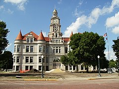
Clarke County is a county located in the U.S. state of Iowa. As of the 2020 census, the population was 9,748. The county seat is Osceola. The county was formed in January 1846, one of twelve counties established by legislative action in a comprehensive act. It was named for James Clarke, a Governor of the Iowa Territory.

<span class="mw-page-title-main">Boone County, Iowa</span> County in Iowa, United States

Boone County is a county in the U.S. state of Iowa. As of the 2020 census, the population was 26,715. Its county seat is Boone.

<span class="mw-page-title-main">Sheldahl, Iowa</span> City in Iowa, United States

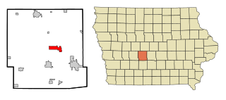
Sheldahl is a city in Polk, Boone, and Story counties in the U.S. state of Iowa. The population was 297 at the time of the 2020 census.

<span class="mw-page-title-main">Adel, Iowa</span> City in Iowa, United States

Adel is a city in and the county seat of Dallas County, Iowa. It is located along the North Raccoon River. Its population was 6,153 at the time of the 2020 Census.

<span class="mw-page-title-main">Bouton, Iowa</span> City in Iowa, United States

Bouton is a city in Dallas County, Iowa, United States. The population was 127 at the 2020 census. It is part of the Des Moines–West Des Moines Metropolitan Statistical Area.

<span class="mw-page-title-main">Clive, Iowa</span> City in Iowa, United States

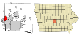
Clive is a city in Dallas and Polk counties in the U.S. state of Iowa. As of the 2020 Census, the population was 18,601. It is part of the Des Moines–West Des Moines Metropolitan Statistical Area. Clive is known for its Greenbelt Park and trail system running through the community. Clive serves as the axis of the western Des Moines suburbs, between Urbandale, Waukee and West Des Moines along the major transportation corridors of I-35, I-80 and I-235. The City of Urbandale is to the north to northwest, the City of West Des Moines is to the southeast to southwest, the City of Waukee in Dallas County is to the west.

<span class="mw-page-title-main">Dallas Center, Iowa</span> City in Iowa, United States

Dallas Center is a city in Dallas County, Iowa, United States. The population was 1,901 during the 2020 census. It is part of the Des Moines–West Des Moines Metropolitan Statistical Area.

<span class="mw-page-title-main">De Soto, Iowa</span> City in Iowa, United States

De Soto is a city in Dallas County, Iowa, United States. The population was 915 at the time of the 2020 census. It is part of the Des Moines–West Des Moines Metropolitan Statistical Area.

<span class="mw-page-title-main">Granger, Iowa</span> City in Iowa, United States

Granger is a city in Dallas and Polk counties in the U.S. state of Iowa. The population was 1,654 at the time of the 2020 census, up 184% from 583 in 2000. It is part of the Des Moines–West Des Moines Metropolitan Statistical Area.

<span class="mw-page-title-main">Grimes, Iowa</span> City in Iowa, United States

Grimes is a city in Polk and Dallas counties in the U.S. state of Iowa. The population was 15,392 at the time of the 2020 Census. Grimes is part of the Des Moines-West Des Moines metropolitan area.

<span class="mw-page-title-main">Urbandale, Iowa</span> City in Iowa, United States

Urbandale is a city in Polk and Dallas counties, Iowa, United States. As of the 2020 U.S. Census, the city population was 45,580. It is part of the Des Moines–West Des Moines Metropolitan Statistical Area.

<span class="mw-page-title-main">Waukee, Iowa</span> City in Iowa, United States

Waukee is a city in Dallas County, Iowa, United States. The population was 23,940 at the time of the 2020 U.S. Census. It is part of the Des Moines – West Des Moines Metropolitan Statistical Area.

<span class="mw-page-title-main">Carlisle, Iowa</span> City in Iowa, United States

Carlisle is a city in Warren and Polk counties in the U.S. state of Iowa. The population was 4,160 at the 2020 census. The city is part of the Des Moines–West Des Moines Metropolitan Statistical Area.

<span class="mw-page-title-main">Des Moines metropolitan area</span> Metropolitan statistical area in Iowa, United States

The Des Moines metropolitan area, officially known as the Des Moines–West Des Moines, IA Metropolitan Statistical Area (MSA) is located at the confluence of the Des Moines River and the Raccoon River. Des Moines serves as the capital of the U.S. state of Iowa. The metro area consists of six counties in central Iowa: Polk, Dallas, Warren, Madison, Guthrie, and Jasper. The Des Moines–Ames–West Des Moines Combined Statistical Area (CSA) encompasses the separate metropolitan area of Ames, and the separate micropolitan areas of Pella, Boone and Oskaloosa. The Des Moines area is a fast-growing metro area.

Raccoon River Valley Trail (RRVT) is a rail trail running 56 miles (90 km) from Waukee, Iowa, to Jefferson, Iowa. In 2013, an additional 33.1-mile (53.3 km) north loop was completed on the RRVT, making the RRVT nearly 90 miles (140 km) of paved trails and having a paved interior loop of more than 72 miles (116 km). The 39-mile (63 km) portion of the trail from Waukee to Herndon is part of the American Discovery Trail, which runs between Cape Henlopen State Park in Delaware and Point Reyes near the Bay Area of California. In Iowa, the American Discovery Trail will be concurrent with U.S. Bicycle Route 50.

References

  1. 1 2 3 "2020 Census State Redistricting Data". census.gov. United states Census Bureau. Retrieved August 12, 2021.
  2. "Find a County". National Association of Counties. Archived from the original on May 31, 2011. Retrieved June 7, 2011.
  3. United States Office of Management and Budget. "Update of Statistical Area Definitions and Guidance on Their Uses" (PDF). pp. 5, 36. Archived from the original (PDF) on May 14, 2006. Retrieved July 21, 2006.
  4. The counties were Boone, Clarke, Dallas, Decatur, Jasper, Lucas, Madison, Marshall, Polk, Story, Warren, and Wayne.
  5. The History of Polk County, Iowa: Containing a History of the County, Its Cities, Towns, &c. Union Historical Co. 1880. pp.  419, 425.
  6. "US Gazetteer files: 2010, 2000, and 1990". US Census Bureau. February 12, 2011. Retrieved April 23, 2011.
  7. Dallas County, Iowa Google Maps (accessed 20 August 2018)
  8. "Annual Estimates of the Resident Population for Counties: April 1, 2020 to July 1, 2023". United States Census Bureau. Retrieved April 2, 2024.
  9. "U.S. Decennial Census". United States Census Bureau. Retrieved July 16, 2014.
  10. "Historical Census Browser". University of Virginia Library. Archived from the original on August 11, 2012. Retrieved July 16, 2014.
  11. "Population of Counties by Decennial Census: 1900 to 1990". US Census Bureau. Retrieved July 16, 2014.
  12. "Census 2000 PHC-T-4. Ranking Tables for Counties: 1990 and 2000" (PDF). US Census Bureau. Archived (PDF) from the original on March 27, 2010. Retrieved July 16, 2014.
  13. "State & County QuickFacts". United States Census Bureau. Archived from the original on June 7, 2011. Retrieved July 16, 2014.
  14. "P2 HISPANIC OR LATINO, AND NOT HISPANIC OR LATINO BY RACE – 2020: DEC Redistricting Data (PL 94-171) – Dallas County, Iowa".
  15. "Population & Housing Occupancy Status 2010" (PDF). US Census Bureau – American FactFinder. Archived (PDF) from the original on October 16, 2020. Retrieved August 15, 2022.
  16. "U.S. Census website". US Census Bureau. Retrieved January 31, 2008.
  17. Leip, David. "Dave Leip's Atlas of U.S. Presidential Elections". uselectionatlas.org. Retrieved December 8, 2020.

Further reading

41°40′58″N94°02′06″W / 41.68278°N 94.03500°W / 41.68278; -94.03500