
Packwood is a city in Jefferson County, Iowa, United States. The population was 183 at the time of the 2020 census. The Burlington and Western Railway arrived in Packwood in late 1882. This was a narrow gauge line, widened to standard gauge in 1902 and taken over by the Chicago, Burlington and Quincy, and then sold to the Minneapolis and St. Louis in 1934.

U.S. Route 34 (US 34) is an east–west United States highway that runs for 1,122 miles (1,806 km) from north-central Colorado to the western suburbs of Chicago. Through Rocky Mountain National Park it is known as the Trail Ridge Road where it reaches elevation 12,183 feet (3,713 m), making it the third highest paved through highway in the United States. The highway's western terminus is Granby, Colorado at US 40. Its eastern terminus is in Berwyn, Illinois at Illinois Route 43 and Historic US 66.

U.S. Route 63 (US 63) is a 1,286-mile (2,070 km), north–south United States Highway primarily in the Midwestern and Southern United States. The southern terminus of the route is at Interstate 20 (I-20) in Ruston, Louisiana; the northern terminus is at US 2 eight miles (13 km) west of Ashland, Wisconsin.
Bladensburg is a small unincorporated community in Wapello County, Iowa, United States. It lies midway between Agency and Batavia at a distance of five miles (8 km) from each, and the largest nearby city is Ottumwa, seven miles (11 km) to the west-southwest.
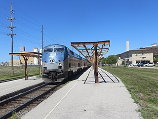
Ottumwa station is an Amtrak intercity train station in Ottumwa, Iowa, United States. The station was originally built by the Chicago, Burlington and Quincy Railroad, and has been listed as Burlington Depot by the National Register of Historic Places since November 26, 2008. It became a contributing property in the Historic Railroad District in 2011.
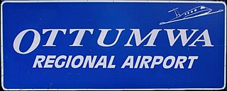
Ottumwa Regional Airport, formerly Ottumwa Industrial Airport, is six miles northwest of Ottumwa, in Wapello County, Iowa. The airport is owned by the City of Ottumwa and is operated by the Airport Advisory Board. It is listed as a general aviation airport in the National Plan of Integrated Airport System (NPIAS) and as an Enhanced Service Airport in the Iowa Aviation System Plan.
Cedar is an unincorporated community in southeastern Mahaska County, Iowa, United States. It lies along Iowa Highway 23 southeast of the city of Oskaloosa, the county seat of Mahaska County.
Sperry is an unincorporated community in central Des Moines County, Iowa, United States. It lies along local roads north of the city of Burlington, the county seat of Des Moines County. Its elevation is 751 feet (229 m). Although Sperry is unincorporated, it has a post office with the ZIP code of 52650, which opened on 5 February 1870.
Little Cedar is an unincorporated community and census-designated place in central Mitchell County, Iowa, United States. As of the 2020 census it had a population of 64. Little Cedar has a post office with the ZIP code of 50454.

Wever is an unincorporated community in northeastern Lee County, in the southeastern corner of Iowa, United States. As of the 2020 census, its population was 101.

An outlying landing field (OLF) is an auxiliary airfield, associated with a seaborne component of the United States military. When associated with the United States Navy, they are known as naval outlying landing fields (NOLFs) or naval auxiliary landing fields (NALFs); when associated with United States Marine Corps, they are known as Marine Corps outlying fields (MCOFs) or Marine Corps auxiliary landing fields (MCALFs).

Naval Outlying Landing Field Choctaw is the United States Navy's designation for an auxiliary airfield that was originally constructed during World War II as Eglin Field Auxiliary Field # 10. It is located 16.6 miles northeast of Pensacola, Florida.
Centerdale is an unincorporated community in Cedar County, Iowa, United States.
Loveland is a census-designated place in Pottawattamie County, Iowa, United States.
Crocker is an unincorporated community in Polk County, Iowa, United States.
Noble is an unincorporated community in Washington County, Iowa, United States.

The Burlington and Northwestern Railway (B&NW) was a 3 ft narrow gauge railroad system in Iowa that operated during the late nineteenth and early twentieth centuries. It connected Burlington, Iowa with branches to Washington and Oskaloosa, Iowa. Incorporated in 1875 as the Burlington and Northwestern Narrow Gauge Railway Company, it began carrying traffic in 1876, when it also dropped 'narrow gauge' from its corporate name. The line reached Washington in 1880, operating over 52.5 miles (84.5 km) of track. In 1881, the Burlington and Western Railway Company, a subsidiary of the Chicago, Burlington and Quincy Railroad (CB&Q) was formed to connect the line to Oskaloosa, completed in 1883. For two decades, both lines were operated as a single system, until on June 20, 1902, the system was widened to standard gauge and the B&NW was adsorbed by the B&W. Later that year, the system was leased to the CB&Q, and in 1903, the entire system was deeded to the CB&Q.
Veo is a former unincorporated community in northwest Penn Township, Jefferson County, in the U.S. state of Iowa.
Abbott is an unincorporated community in Hardin County, in the U.S. state of Iowa. It is at the junction of 150th Street and V Avenue.
Beckwith is an unincorporated community in Jefferson County, in the U.S. state of Iowa.


