
U.S. Route 160 (US 160) is a 1,465 mile (2,358 km) long east–west United States highway in the Midwestern and Western United States. The western terminus of the route is at US 89 five miles (8 km) west of Tuba City, Arizona. The eastern terminus is at US 67 and Missouri 158 southwest of Poplar Bluff, Missouri. Its route, if not its number, was made famous in song in 1975, as the road from Wolf Creek Pass to Pagosa Springs, Colorado in C.W. McCall's country music song Wolf Creek Pass.

U.S. Route 59 is a north–south United States highway. A latecomer to the U.S. numbered route system, US 59 is now a border-to-border route, part of the NAFTA Corridor Highway System. It parallels U.S. Route 75 for nearly its entire route, never much more than 100 miles (160 km) away, until it veers southwest in Houston, Texas. Its number is out of place since US 59 is either concurrent with or entirely west of U.S. Route 71. The highway's northern terminus is 9 mi (14 km) north of Lancaster, Minnesota, at the Lancaster–Tolstoi Border Crossing on the Canada–US border, where it continues as Manitoba Highway 59. Its southern terminus is at the Mexico–US border in Laredo, Texas, where it continues as Mexican Federal Highway 85D.
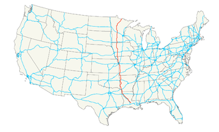
U.S. Route 71 or U.S. Highway 71 is a major north–south United States highway that extends for over 1500 miles (2500 km) in the central United States. This original 1926 route has remained largely unchanged by encroaching Interstate highways. Currently, the highway's northern terminus is in International Falls, Minnesota at the Canada–US border, at the southern end of the Fort Frances-International Falls International Bridge to Fort Frances, Ontario. U.S. Route 53 also ends here. On the other side of the bridge, Trans-Canada Highway is an east–west route while Highway 71 is a north–south route. US 71's southern terminus is between Port Barre and Krotz Springs, Louisiana at an intersection with U.S. Route 190. For the entirety south of Kansas City, Missouri, US 71 runs parallel and concurrent with the existing and future Interstate 49. North of Kansas City, US 71 runs halfway between Interstate 29 and Interstate 35, which they split in the city at an interchange with Interstate 70.
U.S. Route 166 (US 166) is a 164-mile (264 km) west–east United States highway. This route and US-266 are the only two remaining spurs of historic U.S. Route 66, since US-666 was renumbered to US-491 in 2003.
U.S. Route 65 is a north–south United States highway in the southern and midwestern United States. The southern terminus of the route is at U.S. Route 425 in Clayton, Louisiana. The northern terminus is at Interstate 35 just south of Interstate 90 in Albert Lea, Minnesota. Parts of its modern route in Iowa and historic route in Minnesota follow the old Jefferson Highway.
U.S. Highway 218 is an original United States Highway, created in 1926. Although technically a spur of U.S. Route 18, US 218 neither begins nor ends at US 18, but overlaps US 18 for 8 miles (13 km) near Charles City, Iowa. US 218 begins at U.S. Route 136 in downtown Keokuk and ends 319 miles (513 km) away at Interstate 35 and U.S. Route 14 at Owatonna, Minnesota. A large portion of US 218 in Iowa is part of the Avenue of the Saints, which connects St. Louis, Missouri, and Saint Paul, Minnesota.
U.S. Route 30 (US 30) is an east–west arterial surface road in northern Illinois. It runs from across the Mississippi River from Clinton, Iowa, to Lynwood at the Indiana state line. This is a distance of 153.79 miles (247.50 km).

U.S. Highway 90 (US 90), one of the major east–west U.S. Highways in the Southern United States, runs through southern Louisiana for 297.6 miles (478.9 km), serving Lake Charles, Lafayette, New Iberia, Morgan City, and New Orleans. Much of it west of Lafayette and east of New Orleans has been supplanted by Interstate 10 (I-10) for all but local traffic, but the section between Lafayette and New Orleans runs a good deal south of I-10.
New York State Route 70 (NY 70) is a short state highway in the western portion of New York in the United States. It travels through three different counties in just 18.01 miles (28.98 km) and is the primary road to and from the village of Canaseraga. The western terminus of the route is at an intersection with NY 436 in the Livingston County town of Portage. Its eastern terminus is at a junction with NY 36 in the Steuben County town of Dansville. Although NY 70 is mostly signed north–south, it follows a more southeast–northwest alignment and is considered an east–west route by the New York State Department of Transportation (NYSDOT). The portion of the route between Dalton and Canaseraga parallels both Canaseraga Creek and the Norfolk Southern Railway's Southern Tier Line.

Highway 72 is a designation for two east–west state highways in Benton County, Arkansas. A western route of 26.32 miles (42.36 km) runs east from Highway 43 at Maysville to U.S. Route 71B (US 71B) in Bentonville. A second route of 12.67 miles (20.39 km) begins at Interstate 49/US Route 71 (I-49/US 71) in Bentonville and runs northeast to US 62 near Avoca. The route is one of the original Arkansas state highways.
Iowa Highway 2 is a 251-mile-long (404 km) state highway which runs across the southernmost tier of counties in the U.S. state of Iowa. At no point along its route is Iowa 2 more than 15 miles (24 km) from the Missouri state line, except for a small section near its eastern terminus. Iowa 2 stretches across the entire state; from the Missouri River near Nebraska City, Nebraska, to U.S. Highway 61 (US 61) at Fort Madison. Prior to becoming a primary highway, the route was known as the Waubonsie Trail.
U.S. Highway 20 in Iowa is a major east–west artery which runs across the state, separating the northern third of Iowa from the southern two-thirds. It enters Iowa from Nebraska, concurrent with Interstate 129 and U.S Route 75, crossing the Missouri River at Sioux City. US 20 runs in a more-or-less straight line across Iowa, paralleling 42° 27' N. It leaves Iowa in Dubuque by crossing the Mississippi River into Illinois. Since October 2018, US 20 is a four-lane divided highway for its entire length in Iowa.
Iowa Highway 175 (Iowa 175) is a main east–west route in the northern portion of the state. The highway has a length of 221 miles (356 km). Iowa Highway 175 enters the state by a Missouri River crossing between Decatur, Nebraska and Onawa. The highway continues westward as Nebraska Highway 51. Iowa 175's eastern terminus is at a T intersection with U.S. Highway 63 (US 63) in southwestern Black Hawk County.
Iowa Highway 86 (Iowa 86) is a state highway that runs from north to south in northwest Iowa. It begins at U.S. Highway 71 (US 71) in northern Milford and ends at the Minnesota border northwest of Spirit Lake, where it continues onward as Minnesota State Highway 86.
Iowa Highway 57 is a state highway that runs from west to east in northern Iowa. Its western terminus is at U.S. Route 65 northeast of Iowa Falls. Its eastern terminus is at an intersection with U.S. Highway 218, Iowa Highway 27, and Iowa Highway 58 in Cedar Falls. It currently follows much of U.S. Highway 20's old route from Cedar Falls to Iowa Falls.
Pennsylvania Route 660 is a 24.1-mile-long (38.8 km) state highway located in Tioga County in Pennsylvania. The western terminus is at the entrance of Leonard Harrison State Park in Shippen Township. The eastern terminus is at U.S. Route 15 (US 15) and US 15 Business in Richmond Township.
A total of ten special routes of U.S. Route 71 exist.
Iowa Highway 148 is a highway which runs in a north–south direction in southwestern Iowa. It has a length of 67 miles (108 km). The southern end of Iowa Highway 148 is at the Missouri border southwest of Bedford and just northeast of Hopkins, Missouri. The highway continues south into Missouri as Missouri Route 148. The northern end of Iowa 148 is at Interstate 80 (I-80) and U.S. Highway 6 (US 6) north of Anita.
U.S. Route 20 runs its easternmost 153 miles (246 km) in the U.S. state of Massachusetts. The highway crosses the state border from New Lebanon, New York, into Hancock, Massachusetts, and runs eastward to Boston, where it ends at Route 2 in Kenmore Square. It spends the vast majority of its journey paralleling I-90, which has largely superseded US-20 for through travel. Still, US-20 directly serves many towns and local business areas which the Turnpike bypasses.
U.S. Highway 59 (US 59) is a United States Highway that transverses the western third of Iowa. It begins at the Missouri state line southwest of Northboro and travels north in a zigzag pattern through Shenandoah, Avoca, Denison, and Cherokee. It ends at the Minnesota state line east of Bigelow, Minnesota. The highway was designated in 1934, though a concerted effort of community officials along today's route sought to bring a U.S. Highway to their cities for several years prior to US 59's creation.


