
Woodbury County is a county located in the U.S. state of Iowa. As of the 2020 census, the population was 105,941, making it the sixth-most populous county in Iowa. The county seat is Sioux City.

Lyon County is the most northwesterly county of the U.S. state of Iowa. As of the 2020 census, the population was 11,934. The county seat is Rock Rapids.

Ida County is a county located in the U.S. state of Iowa. As of the 2020 census the population was 7,005, making it the state's eighth-least populous county. The county seat is Ida Grove. The county was authorized by the Iowa Legislature in January 1851 as a packet of projected counties in unorganized territory of western Iowa. It was named after Ida Smith, the first child of European immigrants to be born in this region.

Correctionville is a city in Woodbury County, Iowa, United States. It is part of the Sioux City, IA–NE–SD Metropolitan Statistical Area. The population was 766 at the time of the 2020 census. The town name comes from the original survey of the town. Correctionville has been noted for its unusual place name. It is supposedly the longest single-word place name in the state of Iowa.
Danbury is a city in Woodbury County, Iowa, United States. It is part of the Sioux City, IA–NE–SD Metropolitan Statistical Area. The population was 320 at the time of the 2020 census. Danbury has two churches, St. Mary's Catholic Church and the United Methodist Church. Danbury holds a fall celebration called Corn Days during harvest.

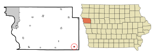
Moville is a city in Woodbury County, Iowa, United States. It is part of the Sioux City, IA–NE–SD Metropolitan Statistical Area. The population was 1,687 in the 2020 census, an increase from 1,583 in 2000.

Pierson is a city in Woodbury County, Iowa, United States. It is part of the Sioux City, Iowa–Nebraska–South Dakota Metropolitan Statistical Area. The population was 337 at the time of the 2020 census. Pierson was platted in 1883 with railroads and lumberyards being important to its growth. The city started with only eight blocks of land until new additions were later made. Pierson has a library, a school district, and five churches, among other businesses and recreation.

Sioux City is a city in Woodbury and Plymouth counties in the northwestern part of the U.S. state of Iowa. The population was 85,797 in the 2020 census, making it the fourth-most populous city in Iowa. The bulk of the city is in Woodbury County, of which it is the county seat, though a small portion is in Plymouth County. Sioux City is located at the navigational head of the Missouri River. The city is home to several cultural points of interest including the Sioux City Public Museum, Sioux City Art Center and Sergeant Floyd Monument, which is a National Historic Landmark. The city is also home to Chris Larsen Park, commonly referred to as "the Riverfront", which includes the Anderson Dance Pavilion, Sergeant Floyd Riverboat Museum and Lewis and Clark Interpretive Center. Sioux City is the primary city of the five-county Sioux City, IA–NE–SD Metropolitan Statistical Area (MSA), with a population of 149,940 in the 2020 census. The Sioux City–Vermillion, IA–NE–SD Combined Statistical Area had a population of 175,638 as of 2020.
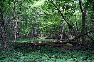
Stone State Park is a state park in Iowa, United States, located in the bluffs and ravines adjacent to the Big Sioux River. The park is located on the northwestern edge of Sioux City and consists of 1,069 acres (433 ha) in Woodbury and Plymouth Counties, and overlooks the South Dakota-Iowa border. Stone Park is near the northernmost extent of the Loess Hills, and is at the transition from clay bluffs and prairie to sedimentary rock hills and bur oak forest along the Iowa side of the Big Sioux River. A variety of prairie plants can be found on the steep slopes and ridges, including yucca, penstemon, rough blazing star, silky aster, and pasque flower. Wild turkey, white-tailed deer, coyote, and red fox are found in the park. Birdlife includes the turkey vulture, barred owl, rufous-sided (eastern) towhee, and the ovenbird. Exposed bedrock in the park is composed of lignite, shale, sandstone, and limestone, and dates to the Cretaceous period; it is rich in marine fossils. The park contains many miles of hiking and equestrian trails, and is a popular destination for day visitors, overnight campers, mountain bike enthusiasts, and picnickers.

Iowa Highway 31 is a diagonal state highway which runs from Iowa Highway 141 (Iowa 141) in Smithland to U.S. Highway 59 (US 59) east of Quimby. For most of its length, the highway runs parallel to the Little Sioux River. Since its designation, the route has changed very little. The route was paved by the mid-1960s.
Climbing Hill is an unincorporated community in Woodbury County, Iowa, United States. Its elevation is 1,135 feet (346 m). The community is part of the Sioux City, IA–NE–SD Metropolitan Statistical Area. It has a post office with the ZIP code 51015.

U.S. Highway 75 (US 75) is a United States Highway in northwestern Iowa. It begins at the Missouri River on a bridge with Interstate 129 (I-129) and US 20. Immediately upon landing in Iowa from Nebraska, I-129 ends at an interchange with I-29. US 20 and US 75 continue around Sioux City on a four-lane expressway until US 20 exits to the east. US 75 heads to the north-northeast, parallel to the Floyd River, until Le Mars. There, Iowa Highway 60 (Iowa 60) continues northeastward on the expressway while US 75 heads due north. Near Hull, it is briefly overlapped by US 18. It leaves the state and enters Minnesota north of Rock Rapids.
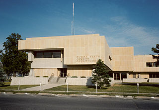
The Buena Vista County Courthouse is located at 215 East 5th Street in Storm Lake, Iowa, United States. Built in 1972, it is the fourth building dedicated to house court functions and county administration.
Lucky Valley is a ghost town in Woodbury County, in the U.S. state of Iowa.
Snyder Grove is a ghost town in Woodbury County, in the U.S. state of Iowa.
Kedron Township is a township in Woodbury County, Iowa, United States.
Rock Township is a township in Woodbury County, Iowa, United States.

Robert Henderson is an American politician.

