Plover, Iowa

Last updated
Plover, Iowa
Pocahontas County Iowa Incorporated and Unincorporated areas Plover Highlighted.svg
Location of Plover, Iowa
Coordinates: 42°52′41″N94°37′22″W / 42.87806°N 94.62278°W / 42.87806; -94.62278 Coordinates: 42°52′41″N94°37′22″W / 42.87806°N 94.62278°W / 42.87806; -94.62278
Country Flag of the United States.svg  United States
State Flag of Iowa.svg  Iowa
County Pocahontas
Area
[1]
  Total0.56 sq mi (1.45 km2)
  Land0.56 sq mi (1.45 km2)
  Water0.00 sq mi (0.00 km2)
Elevation
1,211 ft (369 m)
Population
 (2020)
  Total50
  Density89.29/sq mi (34.47/km2)
Time zone UTC-6 (Central (CST))
  Summer (DST) UTC-5 (CDT)
ZIP code
50573
Area code 712
FIPS code 19-63840
GNIS feature ID0460323

Plover is a city in Pocahontas County, Iowa, United States. The population was 50 at the time of the 2020 census. [2]

Contents

History

Plover was platted in 1883, soon after the Des Moines and Fort Dodge Railroad was built through that territory. The railroad president named the town after the plover bird. [3]

Geography

Plover is located at 42°52′41″N94°37′22″W / 42.87806°N 94.62278°W / 42.87806; -94.62278 (42.878058, -94.622648). [4]

According to the United States Census Bureau, the city has a total area of 0.54 square miles (1.40 km2), all land. [5]

Demographics

Historical populations
YearPop.±%
1920 246    
1930 266+8.1%
1940 280+5.3%
1950 243−13.2%
1960 182−25.1%
1970 129−29.1%
1980 135+4.7%
1990 101−25.2%
2000 95−5.9%
2010 77−18.9%
2020 50−35.1%
Source: "U.S. Census website". United States Census Bureau . Retrieved 2020-03-29. and Iowa Data Center
Source:
U.S. Decennial Census [6] [2]

2010 census

As of the census [7] of 2010, there were 77 people, 34 households, and 20 families living in the city. The population density was 142.6 inhabitants per square mile (55.1/km2). There were 44 housing units at an average density of 81.5 per square mile (31.5/km2). The racial makeup of the city was 98.7% White and 1.3% from two or more races.

There were 34 households, of which 26.5% had children under the age of 18 living with them, 55.9% were married couples living together, 2.9% had a female householder with no husband present, and 41.2% were non-families. 38.2% of all households were made up of individuals, and 11.7% had someone living alone who was 65 years of age or older. The average household size was 2.26 and the average family size was 3.05.

The median age in the city was 46.3 years. 24.7% of residents were under the age of 18; 6.5% were between the ages of 18 and 24; 18.2% were from 25 to 44; 32.5% were from 45 to 64; and 18.2% were 65 years of age or older. The gender makeup of the city was 50.6% male and 49.4% female.

2000 census

As of the census [8] of 2000, there were 95 people, 43 households, and 30 families living in the city. The population density was 174.8 inhabitants per square mile (67.5/km2). There were 50 housing units at an average density of 92.0 per square mile (35.5/km2). The racial makeup of the city was 97.89% White, 1.05% Asian, and 1.05% from two or more races.

There were 43 households, out of which 23.3% had children under the age of 18 living with them, 62.8% were married couples living together, 4.7% had a female householder with no husband present, and 30.2% were non-families. 30.2% of all households were made up of individuals, and 16.3% had someone living alone who was 65 years of age or older. The average household size was 2.21 and the average family size was 2.70.

In the city, the population was spread out, with 16.8% under the age of 18, 7.4% from 18 to 24, 21.1% from 25 to 44, 31.6% from 45 to 64, and 23.2% who were 65 years of age or older. The median age was 46 years. For every 100 females, there were 111.1 males. For every 100 females age 18 and over, there were 113.5 males.

The median income for a household in the city was $29,306, and the median income for a family was $30,625. Males had a median income of $25,750 versus $26,250 for females. The per capita income for the city was $15,241. There were 17.2% of families and 15.2% of the population living below the poverty line, including 46.7% of under eighteens and none of those over 64.

Education

Pocahontas Area Community School District operates public schools. [9] It was in the Havelock-Plover Community School District until July 1, 1989, when it consolidated into the Pocahontas School District, resulting in the Pocahontas Area School District. [10]

Related Research Articles

<span class="mw-page-title-main">Pocahontas County, Iowa</span> County in Iowa, United States

Pocahontas County is a county located in Iowa, United States. As of the 2020 census the population was 7,078, making it the state's ninth-least populous county. The county seat is Pocahontas. The county was formed in 1851.

<span class="mw-page-title-main">Harpers Ferry, Iowa</span> City in Iowa, United States

Harpers Ferry is a city in Taylor Township, Allamakee County, Iowa, United States. The population was 262 at the time of the 2020 census.

<span class="mw-page-title-main">Pomeroy, Iowa</span> City in Iowa, United States

Pomeroy is a city in Calhoun County, Iowa, United States. The population was 526 at the time of the 2020 census.

<span class="mw-page-title-main">Garber, Iowa</span> City in Iowa, United States

Garber is a city in Clayton County, Iowa, United States. The population was 76 at the time of the 2020 census, down from 103 in 2000.

<span class="mw-page-title-main">Magnolia, Iowa</span> City in Iowa, United States

Magnolia is a city in Harrison County, Iowa, United States. The population was 190 at the time of the 2020 census.

<span class="mw-page-title-main">Havelock, Iowa</span> City in Iowa, United States

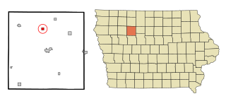
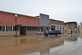
Havelock is a city in Pocahontas County, Iowa, United States. The population was 130 at the time of the 2020 census.

<span class="mw-page-title-main">Laurens, Iowa</span> City in Iowa, United States

Laurens is a city in Pocahontas County, Iowa, United States. Its population was 1,264 at the 2020 census.

<span class="mw-page-title-main">Palmer, Iowa</span> City in Iowa, United States

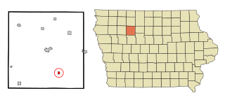
Palmer is a city in Pocahontas County, Iowa, United States. The population was 138 at the time of the 2020 census.

<span class="mw-page-title-main">Pocahontas, Iowa</span> City in Iowa, United States

Pocahontas is a city in and the county seat of Pocahontas County, Iowa, United States. The population was 1,867 in the 2020 census, a decline from the 1,970 population in 2000.

<span class="mw-page-title-main">Rolfe, Iowa</span> City in Iowa, United States

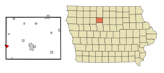
Rolfe is a city in Pocahontas County, Iowa, United States. The population was 509 at the time of the 2020 census.

<span class="mw-page-title-main">Varina, Iowa</span> City in Iowa, United States

Varina is an incorporated small, rural village in Pocahontas County, Iowa, United States. The population was 68 at the time of the 2020 census.

<span class="mw-page-title-main">Redding, Iowa</span> City in Iowa, United States

Redding is a city in southwest Ringgold County, Iowa, United States. The population was 63 at the time of the 2020 census.

<span class="mw-page-title-main">New Liberty, Iowa</span> City in Iowa, USA

New Liberty is a city in Scott County, Iowa, United States. The population was 138 at the time of the 2020 census.

<span class="mw-page-title-main">Weston, Maine</span> Town in Maine, United States

Weston is a town in Aroostook County, Maine, United States. The population was 245 at the 2020 census.

<span class="mw-page-title-main">Linneus, Missouri</span> City in Missouri, United States

Linneus is a small city in Linn County, Missouri, United States. The population was 281 at the 2020 census. It is the county seat of Linn County.

<span class="mw-page-title-main">Broadview, Montana</span> Town in Montana, United States

Broadview is a town in Yellowstone County, Montana, United States. The population was 139 at the 2020 census.

<span class="mw-page-title-main">South Wayne, Wisconsin</span> Village in Wisconsin, United States

South Wayne is a village in Lafayette County, Wisconsin, United States. The population was 489 at the 2010 census.

<span class="mw-page-title-main">Gilmore City, Iowa</span> City in Iowa, United States

Gilmore City is a city in Humboldt and Pocahontas counties in the U.S. state of Iowa. The population was 487 at the time of the 2020 census.

<span class="mw-page-title-main">Clearfield, Iowa</span> City in Iowa, United States

Clearfield is a city in Taylor and Ringgold counties in the U.S. state of Iowa. The population was 278 at the time of the 2020 census.

Madison is a census-designated place (CDP) in the town of Madison in Somerset County, Maine, United States. The population was 2,733 at the 2000 census.

References

  1. "2020 U.S. Gazetteer Files". United States Census Bureau. Retrieved March 16, 2022.
  2. 1 2 "2020 Census State Redistricting Data". census.gov. United states Census Bureau. Retrieved 12 August 2021.
  3. Flickinger, Robert Elliott (1904). The Pioneer History of Pocahontas County, Iowa. G. Sanborn. pp.  699.
  4. "US Gazetteer files: 2010, 2000, and 1990". United States Census Bureau. 2011-02-12. Retrieved 2011-04-23.
  5. "US Gazetteer files 2010". United States Census Bureau. Archived from the original on 2012-01-25. Retrieved 2012-05-11.
  6. "Census of Population and Housing". Census.gov. Retrieved June 4, 2015.
  7. "U.S. Census website". United States Census Bureau . Retrieved 2012-05-11.
  8. "U.S. Census website". United States Census Bureau . Retrieved 2008-01-31.
  9. "Pocahontas Area Archived 2018-04-27 at the Wayback Machine ." Iowa Department of Education. Retrieved on July 20, 2018.
  10. "REORGANIZATION & DISSOLUTION ACTIONS SINCE 1965-66 Archived 2019-02-09 at the Wayback Machine ." Iowa Department of Education. Retrieved on July 20, 2018.