
The Suwannee River is a river that runs through south Georgia southward into Florida in the Southern United States. It is a wild blackwater river, about 246 miles (396 km) long. The Suwannee River is the site of the prehistoric Suwanee Straits that separated the Florida peninsula from the Florida panhandle and the rest of the continent.
Pelican Island National Wildlife Refuge is a United States National Wildlife Refuge (NWR), and part of the Everglades Headwaters NWR complex, located just off the western coast of North Hutchinson Island in the Indian River Lagoon east of Sebastian, Florida. The refuge consists of a 3-acre (12,000 m2) island that includes an additional 2.5 acres (10,000 m2) of surrounding water and is located off the east coast of Florida of the Indian River Lagoon. Established by an executive order of President Theodore Roosevelt on March 14, 1903, Pelican Island was the first National wildlife refuge in the United States. It was created to protect egrets and other birds from extinction through plume hunting.

The Bosque del Apache National Wildlife Refuge is located in southern New Mexico. It was founded in 1939 and is administered by the U.S. Fish and Wildlife Service. It is a favorite spot to watch the migration of the sandhill cranes in the fall. The reserve is open year-round and provides safe harbor for its varied wildlife.
The protected areas of Michigan come in an array of different types and levels of protection. Michigan has five units of the National Park Service system. There are 14 federal wilderness areas; the majority of these are also tribal-designated wildernesses. It has one of the largest state forest systems as well having four national forests. The state maintains a large state park system and there are also regional parks, and county, township and city parks. Still other parks on land and in the Great Lakes are maintained by other governmental bodies. Private protected areas also exist in the state, mainly lands owned by land conservancies.

The Okefenokee National Wildlife Refuge is a 402,000‑acre (1,627 km2) National Wildlife Refuge located in Charlton, Ware, and Clinch Counties of Georgia, and Baker County in Florida, United States. The refuge is administered from offices in Folkston, Georgia. The refuge was established in 1937 to protect a majority of the 438,000 acre (1,772 km2) Okefenokee Swamp. The name "Okefenokee" is a Native American word meaning "trembling earth."
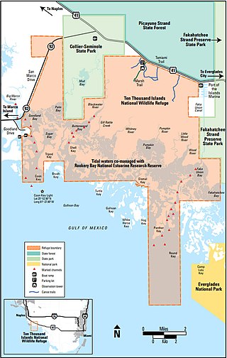
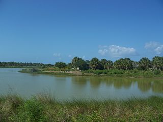
The Ten Thousand Islands are a chain of islands and mangrove islets off the coast of southwest Florida, between Cape Romano and the mouth of the Lostmans River. Some of the islands are high spots on a submergent coastline. Others were produced by mangroves growing on oyster bars. Despite the name, the islets in the chain only number in the hundreds.

Matia Island is an island in the San Juan Islands of the U.S. state of Washington. The island's entire 145 acres (59 ha) comes under the protection of the U.S. Fish and Wildlife Service and is cooperatively managed by the Washington State Parks and Recreation Commission as Matia Island Marine State Park. Matia Island is a National Wildlife Refuge, part of the San Juan Islands National Wildlife Refuge. A 2-acre (0.81 ha) camping area around Rolfe Cove is managed as a State Marine Park by the Washington State Parks and Recreation Commission under an agreement dating back to 1959. Pets, wood collecting, and campfires are not allowed on the island. Except for the Wilderness Loop Trail and the campground, all areas above the high tide line are closed to the public.

According to the California Protected Areas Database (CPAD), in the state of California, United States, there are over 14,000 inventoried protected areas administered by public agencies and non-profits. In addition, there are private conservation areas and other easements. They include almost one-third of California's scenic coastline, including coastal wetlands, estuaries, beaches, and dune systems. The California State Parks system alone has 270 units and covers 1.3 million acres (5,300 km2), with over 280 miles (450 km) of coastline, 625 miles (1,006 km) of lake and river frontage, nearly 18,000 campsites, and 3,000 miles (5,000 km) of hiking, biking, and equestrian trails.

The San Juan Islands National Wildlife Refuge is in the San Juan Islands of the Salish Sea, north of Puget Sound, in the State of Washington. Created in 1976, it comprises 83 small, uninhabited islands, scattered throughout the San Juans, with a combined area of approximately 454 acres (1.84 km2). The Refuge is managed by the U.S. Fish and Wildlife Service as one of six in the Washington Maritime National Wildlife Refuge Complex.

Gravel Island National Wildlife Refuge is a National Wildlife Refuge located off the Door Peninsula in Wisconsin. Founded in 1913, the refuge consists of two Lake Michigan islands that act as nesting grounds for native bird species. It is inhabited by large colonies of shore birds and waterfowl in addition to hosting a pair of great black-backed gulls, one of farthest westward breeding sites of the species.
Green Bay National Wildlife Refuge is a National Wildlife Refuge of the United States located in the state of Wisconsin. It includes five all or part of six islands in Lake Michigan: Hog Island, Plum Island, Pilot Island, part of St. Martin Island and Rocky Island. Additionally it includes part of Detroit Island. The islands are near Washington Island off the tip of the Door Peninsula of Wisconsin and the Garden Peninsula of Michigan.
The Wisconsin Islands Wilderness is a 29-acre (12 ha) wilderness area located in Door County in northeastern Wisconsin. It is one of the smallest wilderness areas in the United States. Managed by the U.S. Fish & Wildlife Service, the wilderness area is composed of three islands in Lake Michigan.
Fortress Island is one of the San Juan Islands in San Juan County, Washington, USA. Located in Lopez Sound, the uninhabited, rocky island has a land area of 3.21 acres and is almost completely devoid of vegetation. It is part of the Turtleback complex, a series of intrusive rocks in Lopez Sound formed out of crystallized molten magma that also includes Bird Rock, Low Island, and others.

Bosque del Apache Wilderness is a designated Wilderness Area on the Bosque del Apache National Wildlife Refuge in Socorro County, New Mexico. Managed by the U.S. Fish and Wildlife Service, the Wilderness, established in 1975, contains 30,427 acres distributed between three units.
Washington Maritime National Wildlife Refuge Complex is an administrative grouping of six National Wildlife Refuges in Washington, managed by the United States Fish and Wildlife Service. It includes:
