Related Research Articles

Erosion is the action of surface processes that removes soil, rock, or dissolved material from one location on the Earth's crust and then transports it to another location where it is deposited. Erosion is distinct from weathering which involves no movement. Removal of rock or soil as clastic sediment is referred to as physical or mechanical erosion; this contrasts with chemical erosion, where soil or rock material is removed from an area by dissolution. Eroded sediment or solutes may be transported just a few millimetres, or for thousands of kilometres.
Soil erosion is the denudation or wearing away of the upper layer of soil. It is a form of soil degradation. This natural process is caused by the dynamic activity of erosive agents, that is, water, ice (glaciers), snow, air (wind), plants, and animals. In accordance with these agents, erosion is sometimes divided into water erosion, glacial erosion, snow erosion, wind (aeolian) erosion, zoogenic erosion and anthropogenic erosion such as tillage erosion. Soil erosion may be a slow process that continues relatively unnoticed, or it may occur at an alarming rate causing a serious loss of topsoil. The loss of soil from farmland may be reflected in reduced crop production potential, lower surface water quality and damaged drainage networks. Soil erosion could also cause sinkholes.

Sediment is a naturally occurring material that is broken down by processes of weathering and erosion, and is subsequently transported by the action of wind, water, or ice or by the force of gravity acting on the particles. For example, sand and silt can be carried in suspension in river water and on reaching the sea bed deposited by sedimentation; if buried, they may eventually become sandstone and siltstone through lithification.
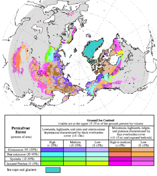
Permafrost is soil or underwater sediment which continuously remains below 0 °C (32 °F) for two years or more: the oldest permafrost had been continuously frozen for around 700,000 years. Whilst the shallowest permafrost has a vertical extent of below a meter (3 ft), the deepest is greater than 1,500 m (4,900 ft). Similarly, the area of individual permafrost zones may be limited to narrow mountain summits or extend across vast Arctic regions. The ground beneath glaciers and ice sheets is not usually defined as permafrost, so on land, permafrost is generally located beneath a so-called active layer of soil which freezes and thaws depending on the season.

In geography and geology, fluvial sediment processes or fluvial sediment transport are associated with rivers and streams and the deposits and landforms created by sediments. It can result in the formation of ripples and dunes, in fractal-shaped patterns of erosion, in complex patterns of natural river systems, and in the development of floodplains and the occurrence of flash floods. Sediment moved by water can be larger than sediment moved by air because water has both a higher density and viscosity. In typical rivers the largest carried sediment is of sand and gravel size, but larger floods can carry cobbles and even boulders. When the stream or rivers are associated with glaciers, ice sheets, or ice caps, the term glaciofluvial or fluvioglacial is used, as in periglacial flows and glacial lake outburst floods. Fluvial sediment processes include the motion of sediment and erosion or deposition on the river bed.

The Lena is a river in the Russian Far East, and is the easternmost of the three great Siberian rivers that flow into the Arctic Ocean. The Lena is the eleventh-longest river in the world, and the longest river entirely within Russia, with a length of 4,294 km (2,668 mi) and a drainage basin of 2,490,000 km2 (960,000 sq mi). Permafrost underlies most of the catchment, 77% of which is continuous.

Scree is a collection of broken rock fragments at the base of a cliff or other steep rocky mass that has accumulated through periodic rockfall. Landforms associated with these materials are often called talus deposits. Talus deposits typically have a concave upwards form, where the maximum inclination corresponds to the angle of repose of the mean debris particle size. The exact definition of scree in the primary literature is somewhat relaxed, and it often overlaps with both talus and colluvium.

The Kobuk River, also known by the names Kooak, Kowak, Kubuk, Kuvuk, and Putnam, is a river located in the Arctic region of northwestern Alaska in the United States. It is approximately 280 miles (451 km) long. Draining a basin with an area of 12,300 square miles (32,000 km2), the Kobuk River is among the largest rivers in northwest Alaska, with widths of up to 1,500 feet and flows reaching speeds of 3–5 miles per hour in its lower and middle reaches. The average elevation for the Kobuk River Basin is 1,300 feet (400 m) above sea level, ranging from sea level at its mouth on the Bering Sea to 11,400 feet near its headwaters in the Brooks Range.

An ice wedge is a crack in the ground formed by a narrow or thin piece of ice that measures up to 3–4 meters in length at ground level and extends downwards into the ground up to several meters. During the winter months, the water in the ground freezes and expands. Once temperatures reach −17 degrees Celsius or lower, the ice that has already formed acts like a solid and expands to form cracks in the surface known as ice wedges. As this process continues over many years ice wedges can grow, up to the size of a swimming pool. Ice wedges usually appear in a polygonal pattern known as ice wedge polygons. The cracks can also be filled with materials other than ice, especially sand, and are then called sand wedges.

Thermokarst is a type of terrain characterised by very irregular surfaces of marshy hollows and small hummocks formed when ice-rich permafrost thaws. The land surface type occurs in Arctic areas, and on a smaller scale in mountainous areas such as the Himalayas and the Swiss Alps.

Pingos are intrapermafrost ice-cored hills, 3–70 m (10–230 ft) high and 30–1,000 m (98–3,281 ft) in diameter. They are typically conical in shape and grow and persist only in permafrost environments, such as the Arctic and subarctic. A pingo is a periglacial landform, which is defined as a non-glacial landform or process linked to colder climates. It is estimated that there are more than 11,000 pingos on Earth, with the Tuktoyaktuk peninsula area having the greatest concentration at a total of 1,350. There is currently remarkably limited data on pingos.
Paraglacial means unstable conditions caused by a significant relaxation time in processes and geomorphic patterns following glacial climates. Rates of landscape change and sediment output from the system are typically elevated during paraglacial landscape response.
Aufeis is a sheet-like mass of layered ice that forms from successive flows of ground or river water during freezing temperatures. This form of ice is also called overflow, icings, or the Russian term, naled. The term "Aufeis" was first used in 1859 by Alexander von Middendorff following his observations of the phenomenon in northern Siberia.
Fluvioglacial landforms or glaciofluvial landforms are those that result from the associated erosion and deposition of sediments caused by glacial meltwater. Glaciers contain suspended sediment loads, much of which is initially picked up from the underlying landmass. Landforms are shaped by glacial erosion through processes such as glacial quarrying, abrasion, and meltwater. Glacial meltwater contributes to the erosion of bedrock through both mechanical and chemical processes. Fluvio-glacial processes can occur on the surface and within the glacier. The deposits that happen within the glacier are revealed after the entire glacier melts or partially retreats. Fluvio-glacial landforms and erosional surfaces include: outwash plains, kames, kame terraces, kettle holes, eskers, varves, and proglacial lakes.
A frost boil, also known as mud boils, a stony earth circles, frost scars, or mud circles, are small circular mounds of fresh soil material formed by frost action and cryoturbation. They are found typically found in periglacial or alpine environments where permafrost is present, and may damage roads and other man-made structures. They are typically 1 to 3 metres in diameter.
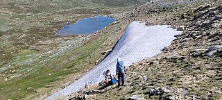
A snow patch, is a geomorphological pattern of snow and firn accumulation which lies on the surface for a longer time than other seasonal snow cover. Snow patches are known by a wide range of synonymous terms including snowpatches, snow beds, snow banks, and ice patches. Snowpatches are categorised by their longevity. Seasonal snowpatches melt prior to the return of the following winter's snowpack, semi-perennial snowpatches last occasionally to the following snowpack, while perennial snowpatches habitually last until the next winter's snowpack.
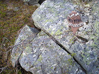
Frost weathering is a collective term for several mechanical weathering processes induced by stresses created by the freezing of water into ice. The term serves as an umbrella term for a variety of processes, such as frost shattering, frost wedging, and cryofracturing. The process may act on a wide range of spatial and temporal scales, from minutes to years and from dislodging mineral grains to fracturing boulders. It is most pronounced in high-altitude and high-latitude areas and is especially associated with alpine, periglacial, subpolar maritime, and polar climates, but may occur anywhere at sub-freezing temperatures if water is present.

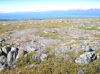
Periglaciation describes geomorphic processes that result from seasonal thawing and freezing, very often in areas of permafrost. The meltwater may refreeze in ice wedges and other structures. "Periglacial" originally suggested an environment located on the margin of past glaciers. However, freeze and thaw cycles influence landscapes also outside areas of past glaciation. Therefore, periglacial environments are anywhere when freezing and thawing modify the landscape in a significant manner.
Stratified slope deposits or grèzes litées are accumulations of debris that are traditionally associated with periglaciation but that can also form in other settings. The deposits have a weak sorting and a coarse bedding. Stratified slope deposits are usually found at the lower slopes of valleys where thicknesses vary but may exceed 10 meters. Periglacial stratified slope deposits are thought to be the result of rock fragmented by frost being accumulated downslope.
Retrogressive thaw slumps (RTS), are a type of landslide that occur in the terrestrial Arctic's permafrost region of the circumpolar Northern Hemisphere when an ice-rich section thaws. RTSs develop quickly and can extend across several hectares modifying Arctic coastlines and permafrost terrain. They are the most active and dynamic feature of thermokarst—the collapse of the land surface as ground ice melts. They are thermokarst slope failures due to abrupt thawing of ice-rich permafrost or glaciated terrains. These horseshoe-shaped landslides contribute to the thawing of hectares of permafrost annually and are considered to be one of the most active and dynamic features of thermokarst—the "processes and landforms that involve collapse of the land surface as a result of the melting of ground ice." They are found in permafrost or glaciated regions of the Northern Hemisphere—the Tibetan Plateau, Siberia, from the Himalayas to northern Greenland, and in northern Canada's Northwest Territories (NWT), the Yukon Territories, Nunavut, and Nunavik and in the American state of Alaska. The largest RTS in the world is in Siberia—the Batagaika Crater, also called a "megaslump", is one-kilometre-long and 100 metres (330 ft) deep and it grows a 100 feet (30 m) annually. The land began to sink, and the Batagaika Crater began to form in the 1960s, following clear-cutting of a section of forested area.
References
- Costard, Francois, E. Gautier, A. Fedorov, P. Konstantinov and L. Dupeyrat. (2014). An Assessment of the Erosion Potential of the Fluvial Thermal Process during Ice Breakups of the Lena River (Siberia). John Wiley & Sons Ltd. p. 162-171.
- Costard, F., E. Gautier, D. Brunstein, J. Hammadi, A. Fedorov, D. Yang, and L. Dupeyat. (2007). Impact of the global warming on the flvial thermal erosion over the Lena River in Central Siberia. The American Geophysical Union.
- Costard, F., L. Dupeyrat, E. Gautier and E. Carey-Gailhardis. (2003). Fluvial Thermal Erosion Investigations Along a Rapidly Eroding River Bank: Application to the Lena River (Central Siberia). Wiley InterScience.
- Dupeyrat, L., F. Costard, R. Randriamazaoro, E, Gailhardis, E. Gautier, A. Fedorov .(2011). Effects of Ice Content on the Thermal Erosion of Permafrost: Implications of Coastal and Fluvial Erosion. Wiley Online Library.
- Randriamazaoro, R., L. Dupeyat, F. Costard and E. Carey Gailhardis. (2007). Fluvial Thermal Erosion: heat balance integral method. Wiley InterScience.
- Notes
- ↑ Dupeyrat, L (2011). "Effects of Ice Content on the Thermal Erosion of Permafrost: Implications for Coastal and Fluvial Erosion". Permafrost and Periglacial Processes. 22 (2): 179–187. Bibcode:2011PPPr...22..179D. doi:10.1002/ppp.722. S2CID 130602564.
- 1 2 French, Hugh M. (2007). The Periglacial Environment (3rd ed.). John Wiley & Sons Ltd. p. 260. ISBN 978-0-470-86588-0.
- ↑ Costard, Francois (2014). "An Assessment of the Erosion Potential of the Fluvial Thermal Process during Ice Breakups of the Lena River (Siberia)". Permafrost and Periglacial Processes. 25 (3): 162–171. Bibcode:2014PPPr...25..162C. doi:10.1002/ppp.1812. S2CID 130195791.
- ↑ Randriamazaoro, R (2007). "Fluvial thermal erosion: heat balance integral method". Earth Surface Processes and Landforms. 32 (12): 1828–1840. Bibcode:2007ESPL...32.1828R. doi:10.1002/esp.1489. S2CID 128500502.