The Oldman Formation is a stratigraphic unit of Late Cretaceous age that underlies much of southern Alberta, Canada. It consists primarily of sandstones that were deposited in fluvial channel and floodplain environments. It was named for exposures along the Oldman River between its confluence with the St. Mary River and the city of Lethbridge, and it is known primarily for its dinosaur remains and other fossils.
The Two Medicine Formation is a geological formation, or rock body, in northwestern Montana and southern Alberta that was deposited between 83.5 ± 0.7 Ma and 70.6 ± 3.4 Ma, during Campanian time. It crops out to the east of the Rocky Mountain Overthrust Belt, and the western portion of this formation is folded and faulted while the eastern part, which thins out into the Sweetgrass Arch, is mostly undeformed plains. Below the formation are the nearshore deposits of the Virgelle Sandstone, and above it is the marine Bearpaw Shale. Throughout the Campanian, the Two Medicine Formation was deposited between the western shoreline of the Late Cretaceous Interior Seaway and the eastward advancing margin of the Cordilleran Overthrust Belt. The Two Medicine Formation is mostly sandstone, deposited by rivers and deltas.
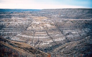
The Horseshoe Canyon Formation is a stratigraphic unit of the Western Canada Sedimentary Basin in southwestern Alberta. It takes its name from Horseshoe Canyon, an area of badlands near Drumheller.

The Scollard Formation is an Upper Cretaceous to lower Palaeocene stratigraphic unit of the Western Canada Sedimentary Basin in southwestern Alberta. Its deposition spanned the time interval from latest Cretaceous to early Paleocene, and it includes sediments that were deposited before, during, and after the Cretaceous-Paleogene (K-Pg) extinction event. It is significant for its fossil record, and it includes the economically important coal deposits of the Ardley coal zone.

The Bearpaw Formation, also called the Bearpaw Shale, is a geologic formation of Late Cretaceous (Campanian) age. It outcrops in the U.S. state of Montana, as well as the Canadian provinces of Alberta and Saskatchewan, and was named for the Bear Paw Mountains in Montana. It includes a wide range of marine fossils, as well as the remains of a few dinosaurs. It is known for its fossil ammonites, some of which are mined in Alberta to produce the organic gemstone ammolite.
The Milk River Formation is a sandstone-dominated stratigraphic unit of the Western Canada Sedimentary Basin in southern Alberta, Canada. It was deposited in near-shore to coastal environments during Late Cretaceous time. Based on uranium-lead dating, palynology and stratigraphic relationships, deposition occurred between ~84.1 and 83.6 Ma.
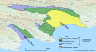
The Kirkwood Formation is a geological formation found in the Eastern and Western Cape provinces in South Africa. It is one of the four formations found within the Uitenhage Group of the Algoa Basin – its type locality – and in the neighbouring Gamtoos Basin. Outcrops of the Kirkwood are also found along the Worcester-Pletmos, Herbertsdale-Riversdale, Heidelberg-Mossel Bay, and Oudtshoorn-Gamtoos basin lines. At these basins the Kirkwood Formation underlies the Buffelskloof Formation and not the Sundays River Formation.
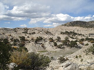
The Belly River Group is a stratigraphical unit of Late Cretaceous age in the Western Canadian Sedimentary Basin.
The Wapiti Formation is a geological formation of the Western Canada Sedimentary Basin in northwestern Alberta, and northeastern British Columbia, Canada. Its deposition spanned the time interval from the lower Campanian through to the upper Maastrichtian, between approximately 80 and 68 Ma. It was named by G.M. Dawson in 1881, presumably for exposures along the lower part of the Wapiti River and downstream along the Smoky River in Alberta.
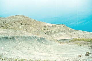
The St. Mary River Formation is a geologic formation of Late Cretaceous age of the Western Canada Sedimentary Basin in southwestern Alberta and northwesternmost Montana. It was first described from outcrops along the St. Mary River by George Mercer Dawson in 1883, and it takes its name from the river.
The North Horn Formation is a widespread non-marine sedimentary unit with extensive outcrops exposed in central and eastern Utah. The formation locally exceeds 3,600 feet (1,100 m) in thickness and is characterized by fluvial, lacustrine, and floodplain dominated systems, representing a terrestrial, high energy, depositional environment. The sediments date from Late Cretaceous (Maastrichtian) to early Paleocene in age and include the K-Pg extinction event boundary; however, this boundary is extremely difficult to locate and there is no strong stratigraphic evidence available that indicates a specific marker bed such as an iridium rich clay layer. Thus far, the only visible evidence is represented in the form of faunal turnover from dinosaur to mammal-dominated fossil assemblages. Taxa from the Cretaceous part of the formation include squamates, testudines, choristoderes, crocodyliforms, sharks, bony fishes, amphibians, mammals, dinosaurs, eggshell fragments, trace fossils, mollusks, plant macrofossils, such as wood fragments, and palynomorphs.
Gething Formation is a stratigraphic unit of Lower Cretaceous (Aptian) age in the Western Canada Sedimentary Basin. It is present in northeastern British Columbia and western Alberta, and includes economically important coal deposits.

The Paskapoo Formation is a stratigraphic unit of Middle to Late Paleocene age in the Western Canada Sedimentary Basin. The Paskapoo underlies much of southwestern Alberta, and takes the name from the Blindman River. It was first described from outcrops along that river, near its confluence with the Red Deer River north of the city of Red Deer, by Joseph Tyrrell in 1887. It is important for its freshwater aquifers, its coal resources, and its fossil record, as well as having been the source of sandstone for the construction of fire-resistant buildings in Calgary during the early 1900s.
The Mist Mountain Formation is a geologic formation of latest Jurassic to earliest Cretaceous age in the Western Canada Sedimentary Basin that is present in the southern and central Canadian Rockies. It was named for outcrops along the western spur of Mist Mountain in Alberta by D.W. Gibson in 1979. The Mist Mountain Formation contains economically important coal seams that have been mined in southeastern British Columbia and southwestern Alberta.
Within the earth science of geology, the Edmonton Group is a Late Cretaceous to early Paleocene stratigraphic unit of the Western Canada Sedimentary Basin in the central Alberta plains. It was first described as the Edmonton Formation by Joseph Burr Tyrrell in 1887 based on outcrops along the North Saskatchewan River in and near the city of Edmonton. E.J.W. Irish later elevated the formation to group status and it was subdivided into four separate formations. In ascending order, they are the Horseshoe Canyon, Whitemud, Battle and Scollard Formations. The Cretaceous-Paleogene boundary occurs within the Scollard Formation, based on dinosaurian and microfloral evidence, as well as the presence of the terminal Cretaceous iridium anomaly.
The Elk Formation is a stratigraphic unit of the Western Canada Sedimentary Basin that is present in southeastern British Columbia and southwestern Alberta. It is probably of Early Cretaceous age, but in some areas its strata could be as old as Late Jurassic. It includes minor thin coal beds and was named for outcrops near the now-abandoned Elk River coal mine east of Fernie, British Columbia.
The Minnes Group, originally named the Minnes Formation, is a geologic unit of latest Jurassic to earliest Cretaceous age in the Western Canada Sedimentary Basin. It is present in the northern foothills of the Canadian Rockies and the adjacent plains in northeastern British Columbia and west-central Alberta. Its strata include natural gas reservoirs and minor coal deposits. Fossil dinosaur tracks have been described from one of its formations.
The Blairmore Group, originally named the Blairmore Formation, is a geologic unit of Early Cretaceous age in the Western Canada Sedimentary Basin that is present in southwestern Alberta and southeastern British Columbia. It is subdivided into four formations: Cadomin Formation, Gladstone, Beaver Mines and Ma Butte, all of which are defined by type sections, most of which contain plant fossils. In some areas the Blairmore contains significant reservoirs of natural gas.
The Bickford Formation is a geologic formation of Early Cretaceous (Valanginian) age in the Western Canada Sedimentary Basin that consists primarily of nonmarine sediments. It is present in the northern foothills of the Canadian Rockies in northeastern British Columbia.
The geology of Alberta encompasses parts of the Canadian Rockies and thick sedimentary sequences, bearing coal, oil and natural gas, atop complex Precambrian crystalline basement rock.


