Forestville, New York

Last updated

Forestville, New York
Hamlet and CDP
Forestville Station - August 2015.jpg
The former Erie Railroad station in Forestville, seen in August 2015.
USA New York location map.svg
Red pog.svg
Forestville
Location within the state of New York
Coordinates: 42°28′18″N79°10′27″W / 42.47167°N 79.17417°W / 42.47167; -79.17417
Country United States
State New York
County Chautauqua
Town Hanover
Settled1808
Incorporated1848
DissolvedDecember 31, 2016 [1]
Area
[2]
  Total1.06 sq mi (2.73 km2)
  Land1.06 sq mi (2.73 km2)
  Water0.00 sq mi (0.00 km2)
Elevation
932 ft (284 m)
Population
 (2020)
  Total704
  Density666.67/sq mi (257.52/km2)
Time zone UTC-5 (Eastern (EST))
  Summer (DST) UTC-4 (EDT)
ZIP code
14062
Area code 716
FIPS code 36-26649
GNIS feature ID0950437

Forestville is a hamlet (and census-designated place) in Chautauqua County, New York, United States. The population was 697 at the 2010 census. [3] The hamlet is within the town of Hanover and in the northeast part of the county. It was an incorporated village from 1848 to 2016.

Contents

History

The first settlers were the Tupper brothers in 1805. The community began in 1808 as "Walnut Falls". Also known as "Moore's Hills," the name was changed to "Forestville" in 1820. The village was incorporated in 1848.

The "Bell Tower" at the high school is the oldest standing brick structure in the north county. The Bell Tower landmark was re-constructed in the early 2000s by Forestville Central School, led by then-Facilities Manager and longtime resident Steve Arnold (class of ‘55). A barn or carriage house located at 29 Lodi Street is the oldest standing wooden structure in northern Chautauqua County. [4]

In 2015, following emergency loans from the county, the inhabitants were called to vote on the dissolution of the village. [5] Dissolution was approved by a 137–97 vote. [6] The Village of Forestville was officially dissolved on December 31, 2016. [1]

Notable people

Geography

Forestville is in the southwest part of the town of Hanover at 42°28′18″N79°10′27″W / 42.47167°N 79.17417°W / 42.47167; -79.17417 (42.471658, -79.174028). [8]

According to the United States Census Bureau, the hamlet has a total area of 0.97 square miles (2.5 km2), all land. [3] Walnut Creek is joined by Tupper B [9] rook north of the hamlet and flows northward to Lake Erie.

CR 85 at the Forestville-Hanover line CR 85 at Forestville-Hanover line.jpg
CR 85 at the Forestville-Hanover line

New York State Route 39 passes east–west through the hamlet as its main street and intersects county routes 85, 87, and 89. Route 39 leads east 12 miles (19 km) to Gowanda. Fredonia is 8 miles (13 km) to the west via Route 39 and U.S. Route 20.

Demographics

Historical population
CensusPop.Note
1860 574
1870 72225.8%
1880 7240.3%
1890 7888.8%
1900 623−20.9%
1910 72115.7%
1920 620−14.0%
1930 6779.2%
1940 6922.2%
1950 78613.6%
1960 90515.1%
1970 9080.3%
1980 804−11.5%
1990 738−8.2%
2000 7704.3%
2010 697−9.5%
2020 7041.0%
U.S. Decennial Census [10]

As of the census [11] of 2000, there were 770 people, 304 households, and 209 families residing in what was then a village. The population density was 787.9123 inhabitants per square mile (304.2146/km2). There were 324 housing units at an average density of 331.5 per square mile (128.0/km2). The racial makeup of the village was 95.45% White, 0.26% African American, 1.04% Native American, 1.43% from other races, and 1.82% from two or more races. Hispanic or Latino of any race were 2.47% of the population. Of note, there is an estimated 91% of the population that is classified as "white".

There were 304 households, out of which 30.3% had children under the age of 18 living with them, 51.0% were married couples living together, 11.8% had a female householder with no husband present, and 31.3% were non-families. 25.0% of all households were made up of individuals, and 10.5% had someone living alone who was 65 years of age or older. The average household size was 2.51 and the average family size was 2.99.

In the village, the population was spread out, with 25.5% under the age of 18, 6.9% from 18 to 24, 28.7% from 25 to 44, 24.0% from 45 to 64, and 14.9% who were 65 years of age or older. The median age was 37 years. For every 100 females, there were 104.2 males. For every 100 females age 18 and over, there were 97.9 males.

The median income for a household in the village was $32,778, and the median income for a family was $41,042. Males had a median income of $32,159 versus $25,139 for females. The per capita income for the village was $15,993. About 4.8% of families and 10.2% of the population were below the poverty line, including 12.0% of those under age 18 and 18.1% of those age 65 or over.

Events

The Forestville Fall Festival, formerly known as the Forestville Apple Festival, is held yearly, the first weekend in October. It features products from the apple harvest, a craft fair, parade, special events, and a harvest dinner.

Related Research Articles

Conewango is a town in Cattaraugus County, New York, United States. The population was 1,794 at the 2020 census. The town is named after a creek which flows through the town.

<span class="mw-page-title-main">Dayton, New York</span> Town in New York, United States

Dayton is a town in Cattaraugus County, New York, United States. The population was 1,689 at the 2020 census. The town is on the western border of Cattaraugus County.

<span class="mw-page-title-main">Busti, New York</span> Town in New York, United States

Busti is a town in Chautauqua County, New York, United States. The population was 7,521 at the 2020 census. The town is named after Paul Busti, an official of the Holland Land Company, but its pronunciation uses a long i sound at the end, a frequent alteration in the names of several upstate New York towns. It has frequently been noted on lists of unusual place names.

<span class="mw-page-title-main">Charlotte, New York</span> Town in New York, United States

Charlotte is a town in Chautauqua County, New York, United States. As of the 2020 census, the town population was 1,521. Charlotte is centrally located in the county, north of Jamestown and south of Dunkirk.

<span class="mw-page-title-main">Chautauqua, New York</span> Town in New York, United States

Chautauqua is a town and lake resort community in Chautauqua County, New York. The population was 4,009 at the 2020 census. The town is named after Chautauqua Lake. It is the home of the Chautauqua Institution and the birthplace of the Chautauqua movement.

<span class="mw-page-title-main">Ellicott, New York</span> Town in New York, United States

Ellicott is a town in Chautauqua County, New York, United States. The population was 8,771 at the 2020 census. The town is named after Joseph Ellicott, an agent of the Holland Land Company.

<span class="mw-page-title-main">Gerry, New York</span> Town in New York, United States

Gerry is a town in Chautauqua County, New York, United States. The population was 1,789 at the 2020 census. The town is named after Elbridge Gerry, the fifth Vice President of the United States. The town is centrally located in the county and is north of Jamestown.

<span class="mw-page-title-main">Hanover, New York</span> Town in New York, United States

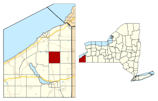
Hanover is a town in Chautauqua County, New York, United States. The population was 6,893 at the 2020 census. The town lies in the northeast corner of Chautauqua County.

<span class="mw-page-title-main">Kiantone, New York</span> Town in New York, United States

Kiantone is a town in Chautauqua County, New York, United States. As of the 2020 census, the town had a population of 1,388. The town is immediately south of Jamestown and is at the south border of the county.

<span class="mw-page-title-main">Mina, New York</span> Town in New York, United States

Mina is a town in Chautauqua County, New York, United States. The population was 1,004 at the 2020 census. It is at the western county border and state line. The town is best known as a summer resort area, centered on the hamlet of Findley Lake.

<span class="mw-page-title-main">North Harmony, New York</span> Town in New York, United States

North Harmony is a town in Chautauqua County, New York, United States. The population was 2,182 at the 2020 census. The town is on the west side of Chautauqua Lake. The shore of the lake is the location of many summer resort communities.

<span class="mw-page-title-main">Sheridan, New York</span> Town in New York, United States

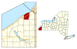
Sheridan is a town in Chautauqua County, New York, United States. The population was 2,563 at the 2020 census. The town is on the county's northern border, east of Dunkirk.

Silver Creek is a village in the town of Hanover in Chautauqua County, New York, United States. As of the 2020 census, the village had a population of 2,637. Silver Creek is named after a small creek which runs through the village. It is on the shore of Lake Erie.

<span class="mw-page-title-main">Villenova, New York</span> Town in New York, United States

Villenova is a town in Chautauqua County, New York, United States. The population was 1,053 at the 2020 census. The town is on the eastern border of the county and is southeast of Dunkirk.

Davenport is a town in Delaware County, New York, United States. The population was 2,955 at the 2020 census. The town is in the northeastern part of the county.

Perrysburg is a town in Cattaraugus County, New York, United States. The population was 1,515 at the 2020 census. The town is named after Commodore Oliver Hazard Perry and is located in the northwest corner of the county. The town contains the census-designated place also named Perrysburg, formerly an incorporated village.

<span class="mw-page-title-main">Cherry Creek (hamlet), New York</span> Hamlet and CDP in New York, United States

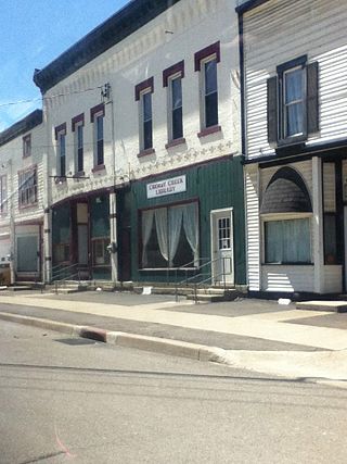
Cherry Creek is a hamlet in Chautauqua County, New York, United States. The population was 461 at the 2010 census, when it was an incorporated village. The hamlet is within the town of Cherry Creek near the east border of the county. It is located on New York State Route 83 and a stream called Cherry Creek.

<span class="mw-page-title-main">Ripley, New York</span> Town in New York, United States

Ripley is a town on Lake Erie in the westernmost part of Chautauqua County, New York, United States. The population was 2,310 at the time of the 2020 census. The town was named after Eleazer Wheelock Ripley, a general in the War of 1812. There are no incorporated villages in the town, but there is one census-designated place: the hamlet of Ripley. The town is perhaps best known as being the western terminus of the New York State Thruway.

Lakewood is a village in Chautauqua County, New York, United States. The population was 2,993 at the 2020 census. The village is in the northern part of the town of Busti.

<span class="mw-page-title-main">Arkwright, New York</span> Town in New York, United States

Arkwright is a town in Chautauqua County, New York, United States. As of the 2020 census, the town population was 1,000. The town is named after Richard Arkwright, the inventor of a spinning device.

References

  1. 1 2 Time Warner Cable News, Village of Forestville Set to Dissolve and Transition Into Town of Hanover by Mark Goshgarian, November 17, 2016, Retrieved January 21, 2017.
  2. "ArcGIS REST Services Directory". United States Census Bureau. Retrieved September 20, 2022.
  3. 1 2 "Geographic Identifiers: 2010 Demographic Profile Data (G001): Forestville village, New York". U.S. Census Bureau, American Factfinder. Archived from the original on February 12, 2020. Retrieved November 10, 2014.
  4. Pamphlet, "Welcome to Chautauqua!", Visitors' Bureau, 1972
  5. Gugino, Nicole (October 21, 2015). "Dissolution in Forestville". Observer . Archived from the original on March 4, 2016.{{cite news}}: CS1 maint: bot: original URL status unknown (link)
  6. Anstey, Evan (November 5, 2015). "Village of Forestville to be dissolved". WIVB-TV . Retrieved November 5, 2015.
  7. Hinton & Olien, Oil in Texas: The Gusher Age, 1895-1945, University of Texas Press, 2002, page 17, ISBN   9780292760561
  8. "US Gazetteer files: 2010, 2000, and 1990". United States Census Bureau. February 12, 2011. Retrieved April 23, 2011.
  9. 1942 business map of Forestville; Water Supply 1964 US Gov't Printing Office; Floods 1965 U. S. Gov't Printing Office
  10. "Census of Population and Housing". Census.gov. Retrieved June 4, 2015.
  11. "U.S. Census website". United States Census Bureau . Retrieved January 31, 2008.