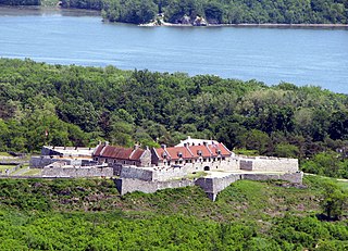
Fort Ticonderoga, formerly Fort Carillon, is a large 18th-century star fort built by the French at a narrows near the south end of Lake Champlain, in northern New York, in the United States. It was constructed by Canadian-born French military engineer Michel Chartier de Lotbinière, Marquis de Lotbinière between October 1755 and 1757, during the action in the "North American theater" of the Seven Years' War, often referred to in the US as the French and Indian War. The fort was of strategic importance during the 18th-century colonial conflicts between Great Britain and France, and again played an important role during the Revolutionary War.

McIntosh County is a county located in the U.S. state of Georgia. As of the 2010 census, the population was 14,333. The county seat is Darien.

Darien is a city in McIntosh County, Georgia, United States. It lies on Georgia's coast at the mouth of the Altamaha River, approximately 50 miles south of Savannah, and is part of the Brunswick, Georgia Metropolitan Statistical Area. The population of Darien was 1,975 at the 2010 census. The city is the county seat of McIntosh County. It is the second oldest planned city in Georgia and was originally called New Inverness.

The Altamaha River is a major river in the U.S. state of Georgia. It flows generally eastward for 137 miles (220 km) from its origin at the confluence of the Oconee River and Ocmulgee River towards the Atlantic Ocean, where it empties into the ocean near Brunswick, Georgia. No dams are directly on the Altamaha, though some are on the Oconee and the Ocmulgee. Including its tributaries, the Altamaha River's drainage basin is about 14,000 square miles (36,000 km2) in size, qualifying it among the larger river basins of the US Atlantic coast. It is the largest river in Georgia.
Fort George was a military fortification in Niagara-on-the-Lake, Ontario, Canada. The fort was used by the British Army, the Canadian militia, and the United States Armed Forces for a brief period. The fort was mostly destroyed during the War of 1812. The site of the fort has been a National Historic Site of Canada since 1921, and features a reconstruction of Fort George.
The Battle of Alligator Bridge took place on June 30, 1778, and was the only major engagement in an unsuccessful campaign to conquer British East Florida during the American Revolutionary War. A detachment of Georgia militiamen under the command of General James Screven chased Thomas Brown's Loyalist company into a large position of British regulars established by British Major Mark Prevost and were turned back.

Prospect Bluff Historic Sites is located in Franklin County, Florida, on the Apalachicola River, 6 miles (9.7 km) SW of Sumatra, Florida. The site contains the ruins of two forts
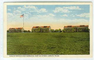
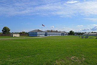
Fort McIntosh was a U.S. Army base in Laredo, Webb County, Texas, from 1849 to 1946.
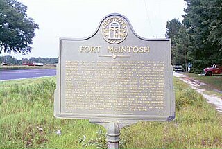
Fort McIntosh is an American military fortification from the American Revolution located near the Satilla River in Brantley County, Georgia, near the present site of the intersection of U.S. Route 82 and Georgia State Route 110 near the town of Atkinson, Georgia.

San Marcos de Apalache Historic State Park is a Florida State Park in Wakulla County, Florida organized around the historic site of a Spanish colonial fort, which was used by succeeding nations that controlled the area. The Spanish first built wooden buildings and a stockade in the late 17th and early 18th centuries here, which were destroyed by a hurricane.

Fort Frederick State Park is a public recreation and historic preservation area on the Potomac River surrounding the restored Fort Frederick, a fortification active in the French and Indian War (1754–1763) and the American Revolutionary War (1775-1783). The state park lies south of the town of Big Pool, Maryland. The Chesapeake and Ohio Canal runs through the park grounds. The site was designated a National Historic Landmark in 1973.

Fort Wayne is located in the city of Detroit, Michigan, at the foot of Livernois Avenue in the Delray neighborhood. The fort is situated on the Detroit River at a point where it is under half a mile to the Ontario shore. The original 1848 limestone barracks still stands, as does the 1845 fort. On the grounds but outside the original fort are additional barracks, officers quarters, hospital, shops, a recreation building, commissary, guard house, garage, and stables.

Fort Miami (Miamis) was a British fort built in spring 1794 on the Maumee River in what was at the time territory claimed by the United States, and designated by the federal government as the Northwest Territory. The fort was located at the eastern edge of present-day Maumee, Ohio, southwest of Toledo. The British built the fort to forestall a putative assault on Fort Detroit by Gen. "Mad" Anthony Wayne's army, then advancing northward in southwestern Ohio.

Fort McIntosh was an early American log frontier fort situated near the confluence of the Ohio River and the Beaver River in what is now Beaver, Pennsylvania.
Fort Clinch is a 19th-century masonry coastal fortification, built as part of the Third System of seacoast defense conceived by the United States. It is located on a peninsula near the northernmost point of Amelia Island in Nassau County, Florida. The fort lies to the northeast of Fernandina Beach at the entrance to the Cumberland Sound, in the northeast part of the state. Today it is included within the boundaries of Fort Clinch State Park.

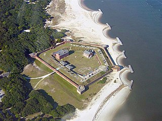
Fort King George State Historic Site is a fort located in the U.S. state of Georgia in McIntosh County, adjacent to Darien. The fort was built in 1721 along what is now known as the Darien River and served as the southernmost outpost of the British Empire in the Americas until 1727. The fort was constructed in what was then considered part of the colony of South Carolina, but was territory later settled as Georgia. It was part of a defensive line intended to encourage settlement along the colony's southern frontier, from the Savannah River to the Altamaha River. Great Britain, France, and Spain were competing to control the American Southeast, especially the Savannah-Altamaha River region.
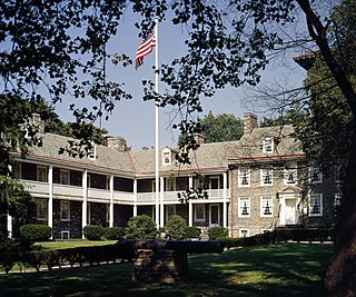
The Old Barracks Museum, also known just as the Old Barracks, is a historic building located at 101 Barracks Street in Trenton, Mercer County, New Jersey. Built in 1758 to house soldiers of the British Army, it is the only remaining colonial barracks in the state and is one of the only tangible surviving elements of the 1776 Battle of Trenton. The building was added to the National Register of Historic Places on January 25, 1971 and listed as a National Historic Landmark on November 28, 1972, for its significance in military history. It is now a state-run historic site and museum.

Lachlan McIntosh was a Scottish American military and political leader during the American Revolution and the early United States. In a 1777 duel, he fatally shot Button Gwinnett, a signer of the Declaration of Independence.
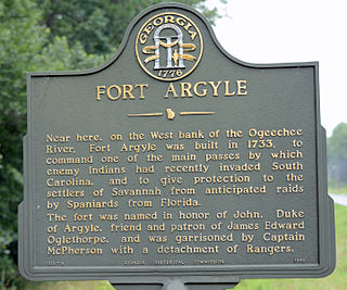
Old Fort Argyle Site is a historic site near Savannah. It is in Fort Stewart in Bryan County, Georgia. It was an English military settlement. It was added to the National Register of Historic Places on March 31, 1975. Access is restricted.

Fort Morris is an earthen works fort in Liberty County, Georgia, in the United States. The fort is on a bend in the Medway River and played an important role in the protection of southeast Georgia throughout various conflicts beginning in 1741 and ending in 1865 at the conclusion of the American Civil War, including the French and Indian and American Revolutionary Wars and War of 1812. The historic site is 70 acres (28 ha) in size and sits at an elevation of 23 feet (7.0 m).


